
PTAX-1-M (R-04/23) Page 1
PTAX 1-M
Introduction to
Mapping for
Assessors
April 2023

PTAX-1-M (R-04/23) Page 2
Printed by the authority of the state of Illinois
PO# 2230316, 15 copies
PTAX-1-M (R-04/23) Page 3
Table of Contents
Glossary ......................................................................................................................... 5
Where to get Assistance ............................................................................................. 11
Unit 1 Basic Types and Uses of Maps ....................................................................... 13
Unit 1 Summary ......................................................................................................... 30
Unit 1 Review Questions ........................................................................................... 31
Unit 2 Measurements and Math for Mapping ............................................................ 33
Unit 2 Summary ......................................................................................................... 46
Unit 2 Review Questions ........................................................................................... 47
Unit 3 The U.S. Rectangular Land Survey ................................................................. 49
Unit 3 Summary ......................................................................................................... 60
Unit 3 Review Questions ........................................................................................... 61
Unit 4 Legal Descriptions ........................................................................................... 63
Unit 4 Summary ......................................................................................................... 90
Unit 4 Review Questions ........................................................................................... 91
Practice Pages ............................................................................................................. 94
Unit 5 Metes and Bounds Legal Descriptions .......................................................... 97
Unit 5 Summary ....................................................................................................... 128
Unit 5 Review .......................................................................................................... 129
Unit 6 Assigning a Property Index Number (PIN) ................................................... 131
Unit 6 Summary ....................................................................................................... 147
Unit 6 Review Questions ......................................................................................... 148
Unit 7 GIS and Mapping ............................................................................................ 151
Unit 7 Summary ....................................................................................................... 158
Unit 7 Review Questions ......................................................................................... 159
Examination Information and Prep .......................................................................... 160
Course Answer Key .................................................................................................. 161
PTAX-1-M (R-04/23) Page 4

PTAX-1-M (R-04/23) Page 5
Glossary
Acre – A unit of land area in England and the U.S. equal to 43,560 square feet.
Ad Valorem – “According to Value”. Our property tax system is based on assessing
property according to value.
Aerial Mosaic - An assembly of aerial photographs to form a continuous photographic
representation of a portion of the earth's surface.
Aerial Photograph - Any photograph taken from the air.
Backsight- Surveying sight taken backward; a sight or reading taken by a surveyor
back toward a position from which a previous sight has been made.
Base Line, Sectionalized Land - Base line is a parallel of latitude, or approximately a
parallel of latitude, running through an arbitrary point chosen as the starting point
for all sectionalized land within a given area.
Bearing - Direction of a line measured as the acute angle from a reference meridian
usually expressed in the form "S 30
o
E" or "N 58
o
W".
Boundary - A line that marks the outermost extent of an area, or a subdivision between
areas.
Cadastral map - A map that shows the size, shape and extent of each land parcel in a
prescribed geographical area, for purposes of describing and recording ownership.
Call – Specific directions to a point.
Cardinal Directions – The directions North, South, East and West and the directions
in-between (Northeast, Northwest, Southeast, Southwest, etc.)
Cartography - The science and art of making maps.
Chain - A land surveyor's measure – 66 feet, or 100 links.
Commencing - Informative term of beginning and/or origin.
Degree - One/360
th
of the circumference of a circle.
Description - The exact location of a piece of property stated in terms of lot, block, and
tract, or by metes and bounds.
PTAX-1-M (R-04/23) Page 6
Exception – A division of an existing or previously defined area of land, and then
excepting out, or removing, an area. The exception can be any exempt area.
This type of description always creates a remainder or other area that must be
described as well.
Furlong – A unit of measure equal to 1/8 of a mile; 660 feet; 220 yards; 40 rods; or 10
chains.
Geodetic Coordinate – Marks a specific point on the earth’s surface.
Geographic Information System (GIS) – A system developed for spatial analysis
needs, such as planning, natural resources, and land records management.
Global Positioning System (GPS) – A satellite-based navigation system made up of
at least 24 satellites owned and operated by the U.S. government.
Grantee - One to whom a grant is made (buyer).
Grantor - The person by whom a grant is made (seller).
Index Maps - (1) A map of smaller scale on which are depicted the location (with
accompanying designations) of specific data, such as larger-scale topographic
quadrangles or geodetic control. (2) A map showing the location and numbers
of flight strips and photographs, made by assembling individual photographs into
their proper relative positions and copying the assembly photographically at a
reduced scale.
Latitude - Angular arc distance north or south of the Equator along a meridian of
longitude. Latitude lines are horizontal circles around the Earth and measure
degrees north or south of the Equator.
Line - Boundary, course, or extension between points; may consist of straight or
curvilinear segments.
Link - Linear measurement equivalent to 7.92 inches or .66 feet. A chain is made up
of 100 links.
Longitude - Angular arc distance east or west of the Prime Meridian along a parallel of
latitude. Vertical circles around the Earth measuring degrees east or west.
Lot and Block – A survey system to locate and identify land, especially in densely
populated areas, based on the division of sectionalized land into quarters.

PTAX-1-M (R-04/23) Page 7
Map - A representation (usually on a flat medium) of all or a portion of the earth,
showing the relative size and position of features to some given scale or
projection. A map may emphasize, generalize, or omit the representation of
certain features to satisfy specific requirements. Maps are frequently
categorized and referred to according to the type of information which they are
designed primarily to convey, to distinguish them from maps of other types.
Map projection - Involves the transformation of a 3-dimensional form into a 2-
dimensional plane; they record the curved surface of the Earth on a flat display.
They may be cylindrical, conical or planar. This is the field of cartography.
Meridian Line - A meridian line is any line running due north and south. Since meridian
lines converge at the North Pole, no two meridians are parallel. Practically within
the limits of a property survey, all lines shown as north, or south are considered
parallel.
Metes and Bounds - Precise description of the boundary lines of parcel of land. Not
described by reference to a lot or block shown on a map but described by
starting at a known point and describing the bearings and distances of the lines
forming the boundaries of the property.
Monuments - Monuments are tangible landmarks indicating boundaries.
1. Physical Monument - A physical monument is an existing feature such as
a stone or stake but not the line of an adjoining property.
2. Natural Monuments - A natural monument is a naturally occurring object
such as a lake, river, tree, boulder, or hill.
3. Artificial Monument - An artificial monument is a man-made object such as
a stake, fence, set stone, etc.
4. Record Monument – A record monument is an adjoining property called
for in a deed such as a street or a parcel of land.
5. Legal Monument - A legal monument is any monument referenced in a
legal description for the purposes of identifying property.
More or Less - The words "more or less" in their ordinary use are to be taken as words
of caution, denoting some uncertainty in the mind of one using them and a desire
not to misrepresent. When used in connection with quantity and distance, "more
or less" are words of safety and precaution, intended merely to cover some slight
or unimportant inaccuracy.
Natural Boundary - Any existing boundary that can be readily identified and located,
e.g., the boundary line of an adjacent parcel of land, a river boundary, ditch, wall,
bluff, etc. Courses and distances, as a rule, give way to a call for a natural
boundary, because a natural boundary, if fixed, is unchangeable, and more likely
to be the true call than courses and distances.
PTAX-1-M (R-04/23) Page 8
Parallel Lines - Lines extending in the same direction and at the same distance apart at
every point so as never to meet.
Parcel - In land ownership mapping for assessment purposes, a parcel is usually held
to be a tract of land under one identical ownership. It may be a combination of
two or more tracts acquired by separate deeds.
Patent - A document granting right to land.
Planimetric map - A map representing only the 2-dimensional, horizontal position of
features measured on plane surfaces.
Plat Map - Usually a survey drawing of an individual parcel of land showing special
characteristics and the locations of any buildings thereon.
Point - "Point" in a boundary is the extremity of a line; spatial location without defined
dimensions.
Point of Beginning (POB) - The reference point at the beginning location of a surveyed
piece of land.
Point of Commencement (POC) - A remote established point from which the true
point of beginning can be identified.
Pole (or rod) – A unit of measure equal to 16.5 feet. Four poles make up a chain.
Political Township - Township units set up by government agencies. They can be
changed at any time and do not necessarily correspond with congressional
township boundaries.
Prime Meridian (Principal Meridian) - Zero Longitude at Greenwich, England. It is the
line from which all other lines of longitude are measured. This includes the line
that runs 180° away from Greenwich also known as the International Date Line.
Property Index Number (PIN) - A series of groupings of numbers that describe the
geographic location and use of a specific tax parcel.
Public Lands Surveys, or Public Land Survey System (PLSS) - In general, the
survey of Federal or State lands or the lands of any other public body. The term,
however, is commonly used to designate the cadastral survey of the public lands
of the U.S.; originally the Government Land Office (G.L.O.) surveys; the present
surveys executed by the Bureau of Land Management (B.L.M.). Synonymous
with rectangular surveys of the U.S. lands; or the rectangular survey system.
Quarter Section - A 160-acre block of land, 1/4 of a section.

PTAX-1-M (R-04/23) Page 9
Range - A vertical column of townships in the rectangular survey system.
Rod (or pole) - A surveyor's lineal measure of 16.5 feet, or 1/4 of a chain.
Scale - Relative ratio of map to ground distances.
Section - A one-mile square block of land containing 640 acres, or one thirty-sixth of a
township.
Soil Survey – The systematic description, classification, and mapping of soils in an
area. These are published by the USDA and can be used to predict the
productivity of soil to grow crops.
Section Number - These are numbers assigned to the one-mile square units within a
survey township. A standard survey township will contain 36 sections.
Standard Parallels - Standard parallels, or correction lines, are parallels of latitude at
intervals of 24 miles north or south of the base line.
Subdivision - A tract of land divided, by means of a map, into lots, or lots and blocks,
for the purpose of resale, generally for residential or agricultural purposes.
Survey - The act or operation of making measurements for determining the relative
position of points, on, above, or beneath the earth's surface; also, the results of
such operations. Photogrammetric survey - A method of surveying that uses
either ground photographs or aerial photographs. Aerial survey - A survey using
aerial photographs. Ground survey - A survey made by ground methods. A
ground survey may or may not include the use of photographs.
Tax Map - A picture of one or more parcels of land showing the boundaries of sub-
divisions of land, with the length thereof, and the areas of individual tracts for the
purpose of describing and recording ownership. It is a graphical representation
on a flat surface of some portion of the earth's surface. It shows the relative size
and position of the land with respect to the other properties, roads, highways and
major topographic features relating to the value and use of the land.
Topographic map - A map which represents the horizontal and vertical positions of the
land features; distinguished from a planimetric map by the addition of relief in
measurable form.
Township (congressional township) - Township is a nearly square area of land
containing 36 sections.
Traverse - A method of surveying in which a sequence of lengths and directions of lines
between points are measured.
PTAX-1-M (R-04/23) Page 10
U.S. Rectangular Land Survey (Government Survey) - In 1785 the U.S. Congress
authorized the first land survey of the United States. It specified that this survey
should divide the land into portions approximately 6 miles square. These
portions are referred to as townships. The townships are surveyed from an east-
west base line and from north-south principal meridians. Townships are laid off
from the base lines and meridians. To identify the townships, each is given an
identification in which it was referred to by its relation to the base line and
meridian. Horizontal tiers of townships are laid off north and south from the base
line and numbered consecutively. Vertical columns of townships, called ranges,
are laid off to the east and west of the principal meridians and numbered
accordingly. The townships can be identified by listing the township tier number
and the range number, such as Township 2 North, Range 2 West. Each
township is usually divided into 36 sections, each approximately one mile square
and containing approximately 640 acres. This may vary considerably at rivers or
where base lines or meridians converge, etc., but generally holds true.
Vector Data – A representation of the world using points, lines, and polygons. These
data are created by digitizing the base data. They store information in x, y
coordinates. Vectors models are used to store data, which have discrete
boundaries like county borders, land parcels and roads.

PTAX-1-M (R-04/23) Page 11
Where to get Assistance
Web Links
Property Tax Division: https://tax.illinois.gov/localgovernments/property.html
Property Tax Code (35ILCS 200): ilga.gov
Illinois Property Tax Appeal Board: ptab.illinois.gov/
Publications
PTAX-1004 The Illinois Property Tax System
https://tax.illinois.gov/content/dam/soi/en/web/tax/research/publications/documen
ts/localgovernment/ptax-1004.pdf
PTAX-1-M (R-04/23) Page 12
PTAX-1-M (R-04/23) Page 13
Unit 1 Basic Types and Uses of Maps
The purpose of this unit is to provide a basic understanding of the different types of
maps and what they are used for. Emphasis will be placed on maps that county officials
will commonly work with.
Learning Objectives
After completing the assigned readings, you should be able to
• identify the different types of maps and their functions.
• locate sources for maps.
• understand the limitations of maps.
Terms and Concepts
Aerial Mosaic
Aerial Photograph
Boundary
Cadastral Map
Index Map
Large Scale
Map
Map Scale
Plat Map
Small Scale
Tax Map
Topographic Map

PTAX-1-M (R-04/23) Page 14
Basic Maps
A map is a two-dimensional representation of the surface of the earth. It depicts spatial
relationships between defined features-roads, buildings, mountains, countries, oceans,
etc. It has been said that “a picture is worth a thousand words”. If that is true, then a
map is worth a thousand pictures. A map can illustrate a vast amount of information,
and that information can be very helpful to an assessor.
The basic functions of maps are to provide:
• Location - where it is.
• Identification - what it is.
• Inventory - how is it categorized.
Maps are usually smaller representations of larger areas. To accurately describe the
difference in size, a map scale is often used. The scale of the map is the linear
measurement on the map described as a ratio to the actual linear physical area of the
subject (the Earth, for instance). Sometimes the measuring tool itself is called a scale,
vs. a ruler or straight-edge, because the tool has multiple scales indicated on the tool
itself, for instance 1:100, 1:200, 1:400, 1:500, 1:600 or even 1:660.
So, a map with a scale of 1” to 100’ means that each 1-inch segment on the map is
equal to 100 feet on the ground. This measurement can be abbreviated as 1:100 or
1” = 100’ or 1 inch = 100 ft. One must pay attention to map scale when trying to
measure distances. The scale is often indicated on the map legend.
Map Legends
A map legend, or key, is included as part of a map to provide the user with information
on the symbols present on the map. The key is often contained in a box or outline near
the map corner and could contain information on color-codes, cardinal directions, year
of the map, scale and other features. Different types of boundary lines are indicated on
the following example:

PTAX-1-M (R-04/23) Page 15
The legend displayed on a GIS map might indicate the Layers of the map.
Small-Scale vs. Large-Scale Maps
Sometimes maps are called small-scale or large-scale maps. A small-scale map
represents a small amount of detail over a wide area (or a larger area with less detail).
An example would be a map of the state of Illinois.
Small Scale Map = Small detail
Large area
A large-scale map represents a large amount of detail over a smaller area with more
detail. An example might be a parcel map.
Large Scale Map = Large detail
Small area
Map Distortions
PTAX-1-M (R-04/23) Page 16
No map is completely accurate because it is impossible to accurately represent the
curved surface of the Earth on a flat piece of paper. A map of a small area usually has
less distortion because there is only a slight curvature of the Earth that affects a small
area. A map of a large area, like a map of the world, is significantly distorted because
the curvature of the Earth over such a large area is substantial.
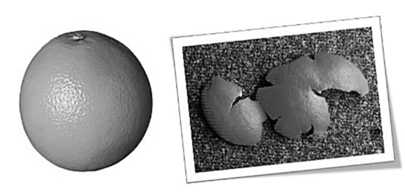
How is the Earth’s surface like an orange peel? Please refer to the following picture.
An orange peel demonstrates distortion in maps. If one tries to look at the entire surface
on a flat plane, the surface of the orange cannot be completely flattened unless
compressed, stretched or torn apart.
Types of Maps
Topographic Maps are usually constructed on a planimetric base, which is a base
representing only the 2-dimensional, horizontal positions of features measured on a
plane surface, but are distinguished by the fact that changes in elevation (relief) are
shown. It represents the horizontal and vertical positions of the land features.
Topographic maps have historically been created by the US Geological Survey (USGS)
and are typically available online or from any public library.
Relief, or elevation changes, are represented by contour lines denoting the ground
elevation as measured from mean sea level, usually in ten-foot increments.
The following map is a topographic map of a part of Jo Daviess County in northwest
Illinois.

PTAX-1-M (R-04/23) Page 17
800’
660’
The curvy lines represent changing areas of elevation as measured above sea level.
The closer together that the curvy lines are, the steeper the terrain. A county and
township overlay have been applied here. As you can see, different elevations are
indicated throughout the map. Notice the 660’ indicated by the arrow. It lies next to the
Galena River. The 800’ indicates a much higher elevation.
The highest elevation in Illinois is in Northwest Illinois in the Driftless area. It is located
at Charles Mound, and the elevation is 1,235 feet above sea level.
The lowest elevation is at the southernmost city of Illinois at Cairo, with an elevation of
315 feet above sea level.

PTAX-1-M (R-04/23) Page 18
Highway maps are prepared on virtually every kind of base, but do not generally have
highly accurate photographic or planimetric characteristics and are available mostly in
small-scale, wide-area formats.
These maps are typically made available through the Illinois Department of
Transportation (IDOT) and illustrate all publicly funded roadways (federal, state, county,
or township).

PTAX-1-M (R-04/23) Page 19
Boundary Maps are usually prepared in combination with one of the previously
mentioned types; the key feature being that some type of boundary information is
provided. A boundary is “a line that marks the outermost extent of an area”. Examples
of boundary maps include maps used for zoning, voting districts, or taxing districts.
Most maps used in the assessment process would be of this type.
Illinois District 4 (political boundary)
Other types of maps used by the assessor include the:
• Plat map - shows property boundaries and ownership.
• Taxing district map - shows the boundaries of taxing districts.
• Cadastral map - shows the size, shape and extent of each land parcel in a
specific geographic area for purposes of describing and recording ownership.

PTAX-1-M (R-04/23) Page 20
Lake County Cadastral Map
Assessment Maps
Besides the plat, taxing district, and cadastral maps used by the assessor, maps may
be known by a variety of names. They may be used interchangeably. The more
commonly used terms are:
• appraisal map.
• assessment map.
• property map.
• tax map.
An assessment map has been defined as "a graphic representation of a portion of the
Earth's surface, containing graphic descriptions of parcels of land indicating their size
and position in relation to other geographic features."

PTAX-1-M (R-04/23) Page 21
Because a parcel portrayed on a map is the graphic representation of a legal
description, the assessment map system must accomplish the following:
1. locate all parcels.
2. identify legal owner.
3. delineate boundaries.
4. inventory improvements.
5. provide administrative data.
6. provide for convenient updating and corrections.
7. provide for easy reproduction.
Maps should be prepared and maintained in such a manner as to give them utility to
other offices or agencies. Considering the property tax cycle, assessment maps should
be updated at least annually to reflect property changes. The larger the number of
users, the more easily justified is the acquisition and maintenance costs of the mapping
system.
Assessment maps are not substitutes for a legal survey.
GIS Image with Parcel Number and Boundary Layer.

PTAX-1-M (R-04/23) Page 22
Photographic maps are prepared directly on an aerial photographic base. The
information stored varies widely with the use of overlays. The base photo may be black
& white, color, or infrared; the size and scale variations are virtually limitless.
Photographic maps are generally used for a large-scale small-area coverage. This
means that an aerial photograph typically represents a small portion of a county rather
than an entire county.
An aerial photograph is any photograph taken from the air. These photographs can be
used to create an aerial mosaic. An aerial mosaic is an assembly of aerial
photographs which form a continuous photographic representation of a portion of the
earth’s surface. It is somewhat like a patchwork quilt in which pieces of fabric are
pieced together to form a quilt.

PTAX-1-M (R-04/23) Page 23
Aerial Base Tax Maps
A base tax map is prepared using aerial photographs specifically created under
controlled conditions. The aerial photographs clearly show all geographical features
such as streets, roads, lakes, streams, railroad, and utility lines and provide a visual
picture of all property in a jurisdiction. Points of reference (control points) on the ground
will have been prominently marked to provide checkpoints on the photography. This
photography is used as the foundation for preparing base maps and the features shown
will assist with the plotting of parcels. These base maps are the base from which the
final tax map is prepared. The aerial photographs should be taken either in early spring
or late fall when foliage will not obstruct the view.
There are several types of aerial photographs. Listed below are a few examples.
An Aerial Photographic Enlargement is nothing more than a “blown-up” photograph.
Neither tilt nor relief displacement are removed for these photographs. Some newer
GIS programs provide oblique 45-degree views that can be used for assessing.

PTAX-1-M (R-04/23) Page 24
A Rectified Aerial Photograph is one in which distortions caused by tilt (the direction
the wings are banked) and yaw (the direction the nose is pointed) of the airplane have
been removed. The objective is to project the image back to its correct shape and
scale. Although relief displacement is not removed from rectified photographs, this type
of photography provides acceptable accuracy for assessment mapping in areas of
relatively flat terrain.

PTAX-1-M (R-04/23) Page 25
An Ortho-photograph is an aerial or satellite image that has the accuracy of a map
drawn from ground survey information because tilt and relief displacement have been
eliminated. Measurements of a land surveyor on the ground should "fit" when plotted
on a true-to-scale ortho-photograph. Distances and area calculations on ortho-
photographs are usually extremely accurate, and property lines will correspond closely
to physical features.
Recommended map scales for aerial photographs are:
1” = 100’ for urban maps (1 inch on the map is equal to 100 feet on the ground).
1” = 400’ for rural maps (1 inch on the map is equal to 400 feet on the ground).

PTAX-1-M (R-04/23) Page 26
Other examples of Ortho-photographs
Dewitt County
LaSalle County
DuPage County
PTAX-1-M (R-04/23) Page 27
Soil Survey Maps
A soil survey describes the characteristics of the soils in each area, classifies the soils
according to a standard system, plots the boundaries of the soil types on a map, and
makes predictions about the behavior of soils. The different uses of the soils and how
the response of management affects them are considered.
Soil survey maps were first used by the Romans! But it wasn’t until 1896 that soil
surveys were first authorized in the United States. By the end of the nineteenth century
the knowledge about soils that had been gained from farming, agricultural chemistry,
biology, and geology grew into a unified concept of the soil itself. Starting with
Assessment Year 2006, farmland assessment in Illinois is based on Bulletin 810
(Average Crop, Pasture, and Forestry Productivity Ratings for Illinois Soils) from the
University of Illinois College of Agriculture.
Different kinds of soil have interrelated properties that define the characteristics of the
soil. These different properties are used to form generalized soil boundaries that are
displayed on a soil map. Modern detailed soil mapping prepared by the Illinois
Cooperative Soil Survey (ICSS) is now available for every county. These maps provide
a detailed inventory of soil types found in a specific area. They also indicate the slope,
erosion, and soil type location. The various soil types are delineated on the soil map
and are numerically coded for identification. The ICSS soil maps contain the level of
accuracy needed to ensure that soil productivity indexes are accurate.
To be eligible for a farmland assessment, property must have been solely used as a
farm for the prior two years and not be part of a primarily residential parcel. Further, all
land use assignments for the property must be in compliance with the Bureau of Census
definitions and IDOR guidelines: for example, cropland, permanent pasture, other
farmland, wasteland and home site acreage.
To determine the value of farmland requires the combination of land use, acreage of
each soil type, slope and erosion debasement factors, flood debasement factors and
debasements due to drainage district assessments.

PTAX-1-M (R-04/23) Page 28
Soil Survey Map
Soil Type
171 B2
Soil Surveys provide the following information.
Soil location - The geographic location and extent of a soil type.
Soil type - A soil type is a group of soils having horizons similar in characteristics
and arrangement in the soil profile and developed from a particular type of parent
material.
Slope - The inclination of the land surface from the horizontal. Percent slope is the vertical
distance divided by the horizontal distance, then multiplied by 100 to change it to a percent.
A = 0% - 2%
B = 2% - 4% The values represented by these
C = 4% - 7% letters are a general rule of thumb.
D = 7% - 12%
E = 12% - 18%
F = 18% - 35%
PTAX-1-M (R-04/23) Page 29
Erosion is an estimate of the maximum average annual rate of soil erosion by wind or
water that can occur over a sustained period without affecting crop productivity. The
higher the value, the more susceptible the soil is to sheet and rill erosion by water.
1 = Un-eroded
2 = Moderately Eroded
3 = Severely Eroded
The first set of numbers on the soil survey represent the type of soil. The letter following
the number indicates the percent of slope. A number following the letter indicates the
amount of erosion.
A soil identified as 171 B2 on a soil map would indicate the following.
171 = soil type (Catlin silt loam)
B = a slope of 2% to 4%
2 = moderate erosion
PTAX-1-M (R-04/23) Page 30
Unit 1 Summary
A map is the 2-dimensional representation of a portion of the earth’s surface.
The basic functions of maps are to provide location, identification, and inventory.
A large-scale map shows a large amount of detail of a smaller or more limited area.
A small-scale map shows a small amount of detail on a large area.
A map legend is a key used to provide the user with information on symbols and
features present on a map.
Some types of maps are:
• Topographic
• Photographic
o Aerial Base Tax Map
o Aerial Mosaic
o Enlargement
o Rectified
o Ortho-rectified
• Highway
• Boundary
• Soil
• Assessment, Tax or Cadastral
• GIS
A map that shows the size, shape and extent of each land parcel in a prescribed
geographical area for purposes of describing and recording ownership is called a tax
(assessment) map or a cadastral map. These maps should be updated annually.
A map which represents the horizontal and vertical positions of the land features and
shows the relief in a measurable form is a topographic map.
An aerial mosaic is an assembly of aerial photographs forming a continuous
photographic representation of a portion of the earth’s surface.
A soil survey provides information concerning soil type, slope, erosion and soil location
information. Soil type is a group of soils having horizons similar in characteristics and
arrangement in the soil profile and developed from a parent material.
Maps are available in different sizes and degrees of detail. A map taken from the air is
called an aerial photograph. Aerial photographs are available at different scales which
affect the degree of detail provided. The recommended map scale for aerial photograph
is: 1” = 100’ for urban maps and 1” = 400’ for rural maps. Assessment maps should be
updated every year.
PTAX-1-M (R-04/23) Page 31
Unit 1 Review Questions
1. What is an aerial mosaic map? ____________________________________
_____________________________________________________________
_____________________________________________________________.
2. What is a topographic map? ______________________________________
_____________________________________________________________
____________________________________________________________.
3. What is a cadastral map? ________________________________________
_____________________________________________________________
_____________________________________________________________.
4. What is the recommended scale for an urban aerial-based tax map?
__________________________________________
5. What is the recommended scale for a rural aerial-based tax map?
__________________________________________
6. What are the basic functions of maps?
1. _________________________________
2. _________________________________
3. _________________________________
PTAX-1-M (R-04/23) Page 32
7. A Soil Survey Map has 3 sets of alphanumeric characters which indicate what
features of the soil (in order):
__________________ ___________________ ___________________
PTAX-1-M (R-04/23) Page 33
Unit 2 Measurements and Math for Mapping
Learning Objectives
After completing the assigned readings, you should be able to
• calculate area for a square, rectangle, or triangle.
• recognize older units of measurement.
• calculate area for complex shapes.
Terms and Concepts
Chain
Parcel
Rod
Link
Acre

PTAX-1-M (R-04/23) Page 34
History of Measurements
Our measurement system, which has been evolving since the time of the Egyptians,
came to us by the way of the English. Here, according to National Geographic, is how
some of the measuring units began.
King Edgar’s Thumb and Charlemagne’s Foot
(Note: You will not be responsible for the following nine definitions on your exam.)
Barleycorn – The length of a grain of barley. Three barleycorns equal one inch.
Inch – The width across the knuckle on King Edgar’s thumb, or 3 barleycorns.
Foot – The length of Charlemagne’s foot, modified in 1305 to be 36 barleycorns
laid end to end.
Cubit – The length of the arm from elbow to fingertip.
Yard – The reach of King Henry I’s nose to his fingertips, a distance twice as long
as a cubit.
Fathom – The span of a seaman’s outstretched arms; 880 fathoms make a mile.
Furlong – The length of a furrow a team of oxen could plow before resting
Mile – 1,000 double steps of a Roman legionary. Later Queen Bess added
more feet so a mile would equal 8 furlongs.
Acre – The amount of land a yoke of oxen could plow in one day.

PTAX-1-M (R-04/23) Page 35
Land Measurement
As the value of land often depends on its area (square foot), it is essential that the
utmost care be taken when calculating acreage. The area of most odd shaped tracts will
have to be calculated by dividing the tract into rectangles and triangles or portions of
circles. Historically, tools used by surveyors dictated the units of measure for property
descriptions. Even though modern technology provides more precise measurements,
there are still thousands of legal descriptions filed at county offices that use these
surveyor units.
1 chain = 66 feet or 100 links
1 link = .66 ft. = 7.92 inches
1 rod (or pole) = 16.5 feet (4 rods = 1 chain)
1 acre = 43,560 square feet
1 furlong = 660 ft.
1 barleycorn = 1/3 inch (3 barleycorns = 1 inch)
Using and Converting Units of Measure
If a legal description says “from the point of beginning, travel 12 chains, 3 rods and 6
links to …” the calculation of distance would be as follows:
1 chain = 66 feet 66 feet x 12 = 792 feet
1 rod = 16.5 feet 16.5 feet x 3 = 49.5 feet
1 link = .66 feet .66 feet x 6 = 3.96 feet
Total distance traveled would be 845.46 feet
Always convert to feet before you do the calculation!

PTAX-1-M (R-04/23) Page 36
Measuring Parcel Area
Square/Rectangle Area = Length x Width
If the length of a rectangle is 100 feet, and the width
of the rectangle is 50, by multiplying 100 x 50, the area
of the rectangle would be 5,000 square feet.
Right Triangle Area = Base x height
2
For right triangles, calculating the area is identical to that of
calculating the area of a rectangle, except the area is divided
in half because a right triangle is half of a rectangle.
If the base of the triangle is 75 feet and the height is 150,
multiply 75 x 150, the area of a rectangle would be B
11,250 square feet. Divide this area by 2 would give an area of 5,625
square feet for the right triangle.
Circle Area = π x radius
2
(Pi R Squared)
[π ≈ 3.1416]
Note: For the purposes of this class, parcels containing portions of
a circle will not be used. However, it should be noted that the area
of a circle may be needed when calculating parcels located on cul-de-sacs.
The radius of a circle is the distance from the center of a circle to the periphery or
outside of the circle. If the radius of the circle is 25 feet, by taking 25 X 25, the radius
squared = 625. Multiplying 625 by 3.1416, the area of the circle is equal to 1,963.5
square feet.
R
h
L
W

PTAX-1-M (R-04/23) Page 37
Acreage
Once the square footage for a parcel has been determined, the acreage can be
determined by dividing the square footage of the parcel by 43,560, the number of
square feet in an acre.
Acreage = Square feet
43,560
The rectangle, which contained 5,000 square feet, would equal .1148 of an acre.
5,000 ÷ 43,560 = .1148 or .11 rounded
The right triangle, which contained 5,625 square feet, would equal .1291 of an acre.
5,625 ÷ 43,560 = .1291 or .13 rounded
The circle, which contained 1,963.5 square feet, would equal .0451 of an acre.
1,963.5 ÷ 43,560 = .0451 or .05 rounded

PTAX-1-M (R-04/23) Page 38
Exercise 2-1 Land Measurement
Compute the square footage and the acreage for the following (assume all triangles are
right triangles). Note: “ch.” refers to chains, “rds.” refers to “rods”, and “lks.” refers to links.
When calculating some of the parcels, it will first be necessary to convert the
measurements to linear feet. Carry out answer to two decimal places. When rounding,
5 and over, round up. Under 5, round down.
Parcel shape Measurements Square Footage Acreage
1. Square 1,528 ft. x 1,528 ft.
2. Square 680 ft. each side
3. Rectangle 1,250 ft. x 1,000 ft.
4. Rectangle 125 ft. x 75 ft.
5. Square 65 ch. x 65 ch.
6. Rectangle 30 ch. x 48 ch.
7. Triangle 475 ft. x 986 ft.
8. Triangle 680 ft. x 360 ft.
9. Triangle 22 ch. x 48 ch.
10. Triangle 38 ch. x 46 ch.
11. Square 5 rds. x 5 rds.
12. Rectangle 5 rds. x 7 rds.
13. Rectangle 200 lks. x 300 lks.
14. Square (8 chains, 3 rods, 16 links)
Note: Each side is 8 chains + 3 rods + 16 links
1 chain = 66 feet
1 link = .66 ft. (7.92 inches)
1 rod (or pole) = 16.5 feet
1 acre = 43,560 sq. ft.
Acreage = # Square feet
43,560

PTAX-1-M (R-04/23) Page 39
Measuring Irregular Rectangular Parcels
Example 1
By breaking down parcels into shapes we can measure easily, we can measure squares
and rectangular shapes that define a property.
For instance, let’s look at the shape A below.
At first glance, it may not be apparent
that there are at least three ways to
approach measuring this parcel.
The first step is to determine the
dimensions.
Notice that every measurement is not
included on the diagram. It is assumed that
the assessor can “fill in the blanks” if all the
dimensions are not shown.
Recall that the opposite sides of a rectangle have
the same measure. For instance, if the length of the
northernmost line is 100’, and the length of the
southernmost line is 40’, it can be deduced that the length
of the remaining east-west line is 60’ (100’-40’ = 60’)
This shape could be measured in a
few different ways. You might select
the way that you visualize most easily
or the method which uses the fewest
number of calculations.
We will look at three different ways
to measure this shape and find the
correct number of square feet.
The shape could be divided into the shapes A & B.
A = 60’ x 30’ = 1,800 SF
B = 75’ x 40’ = 3,000 SF
1800 SF + 3,000 SF = 4,800 SF
A
45’
40’
75’
100’
40’
A
B
60’
30’
75’
?
?

PTAX-1-M (R-04/23) Page 40
Another way to measure this parcel
is to divide it into two rectangles this way.
The measurements would be:
A = 100 x 30 = 3,000SF
B = 40 x 45 SF = 1,800 SF
3,000 SF + 1,800 SF = 4,800 SF
Finally, yet another way to measure this parcel could be subtractive. Measure the
imaginary outline of the entire rectangle and subtract the part that is “missing”.
The measurements would be:
A = 75’ x 100’ = 7,500 SF
B = 60’ x 45’ = 2,700 SF
7,500 SF – 2,700 SF = 4,800 SF
Notice that all 3 methods produce
The same result of 4,800 SF.
To find the number of acres in this parcel, divide the number of square feet by the
number of SF in an acre (43,560).
4,800 SF = .1102 Acres
43,560 SF
A
B
45’
30’
40’
60’
A
45’
40’
75’
100’
60’
B

PTAX-1-M (R-04/23) Page 41
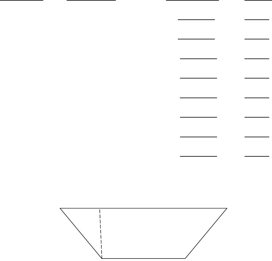
Measuring Irregular Parcels with Triangular Shapes
By breaking down parcels into series of rectangles and triangles and using the
measurements provided, you would be able to calculate the area of almost any parcel.
Example 2
In this example, the parcel is drawn with the outer boundary measurements provided
Step 1 Create a rectangle.
A Right Triangle (90
o
) can be created (Triangle A) leaving Rectangle B.
Step 2 In this example, the area of Rectangle B can be calculated using known
values of 990 feet for the length and 595 feet for the width.
Area of the rectangle = 990 feet x 595 feet = 589,050 square feet.
Area = L x W
990
ft.
595
ft.
1320
ft.
680 ft.
A
B
990 ft.
595 ft.
1320 ft.
680 ft.

PTAX-1-M (R-04/23) Page 42
Step 3 The remaining area of the parcel is that of Right Triangle A. However, looking
at the triangle, there do not appear to be any usable values. This is a good
opportunity to point out a very important note. The hypotenuse of the triangle
(the long side of the triangle, in this example the line labeled as 680 ft.) is not
used in calculating the area of a triangle. The area of a right triangle is
calculated by multiplying the base times the height and dividing the product by
two. The hypotenuse (long side) is never used.
In this example, the base and height values must be determined from the other
measurements provided. As a result, the height of Right Triangle A is the height of
Rectangle B (595 feet). For the base of the triangle, that value can be determined from
the existing
values as well. The base of Rectangle B is 990 feet. Considering the
entire length of the bottom of the parcel is 1,320 feet and knowing that Triangle A is a
right triangle, then the base of Right Triangle A is 1,320 feet minus 990 feet, or 330
feet.
A
B
90º
589,050 SF
990 ft.
595 ft.
680 ft.
1,320 ft.
A
B
90º
589,050 SF
990 ft.
595
ft.
1,320 ft.
330 ft.
595 ft.

PTAX-1-M (R-04/23) Page 43
Therefore, the area of Right Triangle A is:
595 ft. x 330 ft. = 98,175 square feet.
2
Step 4 Calculate the total acreage of the parcel. By taking the square footage of Right
Triangle A, which equals 98,175, and adding the square footage of Rectangle
B, which equals 589,050, we arrive at a total of 687,225 SF for the parcel. By
dividing the total area of the parcel (687,225 SF by 43,560 SF) we arrive at a
total of 15.78 acres for the parcel.
589,050 SF + 98,175 SF = 687,225 SF = 15.78 AC
43,560 SF

PTAX-1-M (R-04/23) Page 44
Example 3
Find the area (in square feet and acres) of the figure below.
First divide the figure into rectangles and right triangles.
Remember that the opposite sides of rectangles have the same measure. The base of
the triangle is found by subtracting the length of the side of the rectangle from the length
of the whole side.
470’ – 280’ = 190’
470’
28
0
’
250’
31
0
’
250’
A
C
B
280’
28
0
’
470’
190’
A
C
B

PTAX-1-M (R-04/23) Page 45
The area of rectangle A = 280’ x 250’ = 70,000 SF. The area of the triangle C can be
determined with the formula for finding the area of a triangle (B x h).
2
190’ x 250’ = 23,750 SF
2
Now the area of rectangle B can be determined again using the mathematical fact that
opposite sides of a rectangle have the same measure.
250’ X 310’ = 77,500 SF
Finally, add A + B + C = 70,000 SF + 23,750 SF + 77,500 SF = 171,250 SF
Acreage = 171,250 SF = 3.93 acres
43,560 SF
250’
280’
190’
470’
280’
250’
310’
250’
280’ X 250’ = 70,000 SF
250’ X 190’
2
= 23,750 SF
250’ X 310’ = 77,500 SF
250’
250’
A
C
B
280’
280’
190’
250’
310’

PTAX-1-M (R-04/23) Page 46
Unit 2 Summary
Legal descriptions are often written using various units of measure. The descriptions
often describe tracts of land in various shapes. While modern surveys for legal
descriptions use common terms of feet or inches, dimensions on older surveys were
often given in chains, rods, or links.
L x W = Area of a Rectangle
L x W = Area of a Triangle
2
Also, all legal descriptions are not square or even regularly shaped. It is often
necessary to convert to common units of measurement or to apply simple geometry to
calculate acreage.
1 chain = 66 feet
1 link = .66 ft. (7.92 inches)
1 rod (or pole) = 16.5 feet
1 acre = 43,560 sq. ft.
Acreage = # Square feet
43,560
Convert all measurements to feet before calculating areas.
Once the square footage of a parcel has been calculated, the acreage can then be
determined by dividing the square footage by 43,560 square feet.
Round measurements to the nearest inch or to 2 decimal points. 5 and over, round up-
under 5, round down.
PTAX-1-M (R-04/23) Page 47
Unit 2 Review Questions
Carry out the SF to closest whole number. Carry out acreage to two decimal places.
Parcel shape Measurements Square Footage Acreage
1. Square 1,742 ft. x 1,742 ft.
2. Rectangle 165 ft. x 95 ft.
3. Square 82 ch. x 82 ch.
4. Triangle 720 ft. x 490 ft.
5. Triangle 27 ch. x 36 ch.
6. Rectangle 9 rds. x 6 rds.
7. Rectangle 500 lks. x 38 rds.
8. Square (6 chains, 2 rods, 23 links)
9. Calculate the square footage and the acreage for the following parcel. Note that the
figure is the same on the right side as on the left side.
225’
A = _______ SF
B = _______ SF
C = _______ SF
Total ___________ SF Total Acres =___________
125’
A
B
C
100’

PTAX-1-M (R-04/23) Page 48
10. Calculate the square footage and acreage for the following parcel.
SF ____________
Ac ___________
150’
75’
200’
50’
150’
PTAX-1-M (R-04/23) Page 49
Unit 3 The U.S. Rectangular Land Survey
Learning Objectives
After completing the assigned readings, you should be able to
• understand the history of the U.S. Rectangular Land Survey.
• define the components of survey system.
• locate a position using the system.
Terms and Concepts
Baseline
Government Survey
Latitude
Longitude
Political Township
Principal Meridian
Section
Section Number
Township
Meridian Line
Quarter Section
Range
PTAX-1-M (R-04/23) Page 50
A Little History…
Historically, land was surveyed using the indiscriminate metes and bounds system. This
survey system used natural land features, such as trees and streams, as well as
neighboring land owners, along with distances to describe plots of land. Realizing that
metes and bounds descriptions would never prove satisfactory in the largely uninhabited
Northwest Territory (what is now Ohio, Indiana, Illinois, Michigan, and Wisconsin), the
Continental Congress knew it had to develop a plan for the orderly sale of individual tracts
to the public. In 1784, a committee headed by Thomas Jefferson developed a plan for
dividing this public land into rectangles. The new system was based on a series of
coordinates – meridians and base lines – plotted astronomically by surveyors.
The Continental Congress established the rectangular survey system in the Land
Ordinance of 1785, also known as the Northwest Ordinance. Under terms of the
Ordinance, Congress was to appoint one surveyor from each state to serve under the
direction of the Geographer of the United States.
The basic plan called for by Jefferson’s committee developed three theories:
1. the principal of "survey before settlement".
2. the principal of a mathematically designed plan to be followed throughout the
entire public domain area.
3. the creation of a standard land unit, the section of uniform shape and area
and with boundaries physically marked on the ground.
On October 1, 1796, Washington appointed Rufus Putnam as the first Surveyor General
of the United States. He was the author of the present numbering system and placed
the excess and deficiency in the North and West tiers of the townships. The Land Act of
1796 was the first law concerning surveys.
Between 1851 and 1855 the Land Act was amended several times and set the pattern
for the present-day survey system.
The Rectangular Survey System as we know it today is a system based on tiered
townships and ranges that are tied to thirty-five established principal meridians located
across the country.
Boundaries for the Rectangular Survey System were usually marked by placing markers
or using prominent trees as boundary markers. These boundary markers are referred
to as monuments.

PTAX-1-M (R-04/23) Page 51
Monuments are tangible landmarks indicating boundaries. There are 5 different types
of monuments.
1. A physical monument is an existing feature such as a stone or stake but not
the line of an adjoining property.
2. A natural monument is a naturally occurring object such as a lake, river, tree,
boulder or hill.
3. An artificial monument is a man-made object such as a stake, fence, set
stone, etc.
4. A record monument is an adjoining property called for in a deed such as a
street or a parcel of land.
5. A legal monument is any monument referenced in a legal description for the
purposes of identifying property.
The map below illustrates the principal meridians and baselines within the United
States.
US Principal Meridians and Baselines

PTAX-1-M (R-04/23) Page 52
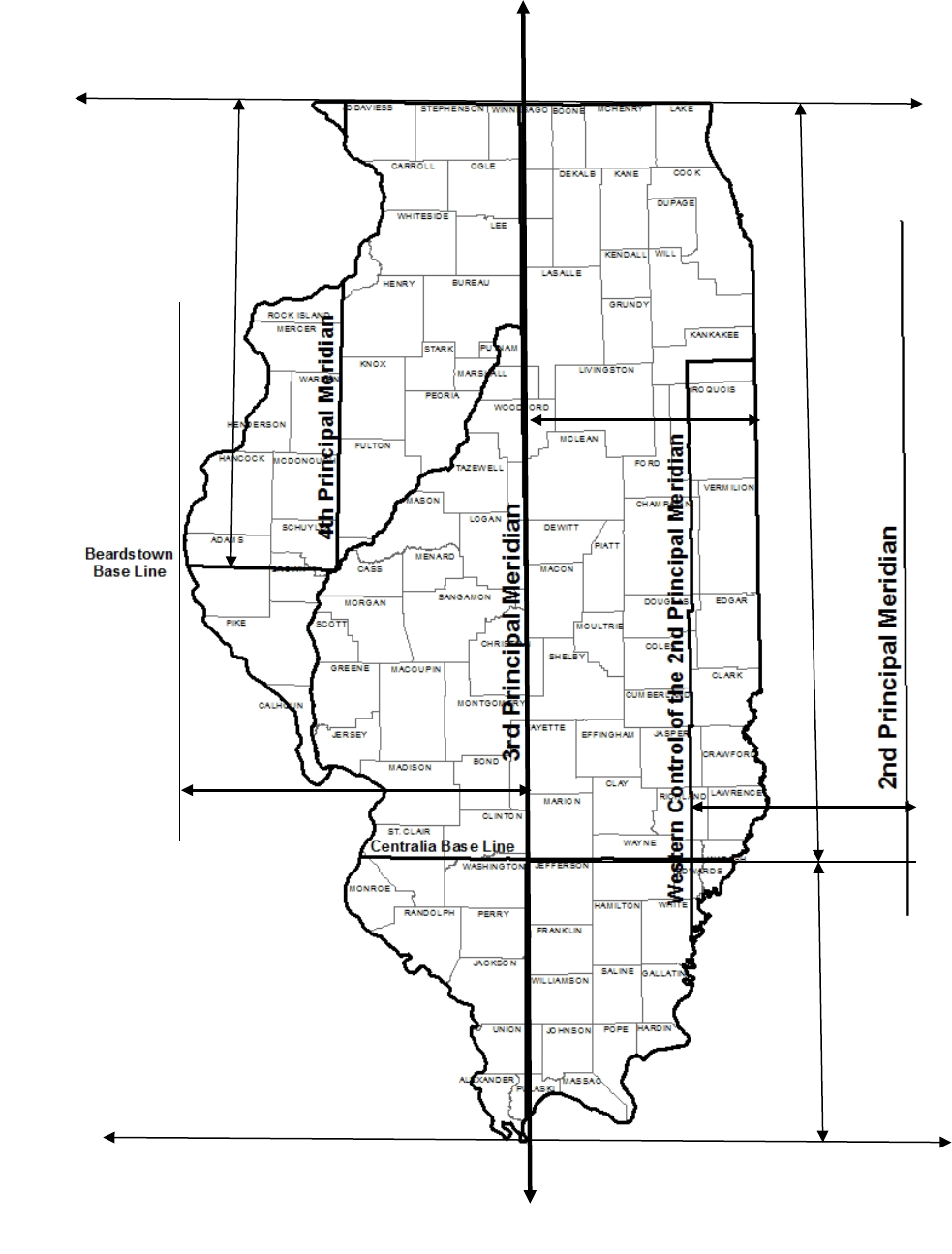
Illinois Meridians and Baselines
A latitude line is an east-west circle, measuring degrees north or south of the Equator.
A baseline is a parallel of latitude running through an arbitrary point chosen as the
starting point for all sectionalized land descriptions within a given area.
Indiana

PTAX-1-M (R-04/23) Page 53
A longitude line is a north-south circle measuring degrees east and west of zero
longitude at Greenwich, England. A principal meridian is an arbitrary line of longitude
used as a starting point and reference for all sectionalized land.
In Illinois, there are two baselines and reference to three principal meridians. The most
prominent meridian is the Third Principal Meridian, which virtually cuts Illinois in half.
Where a baseline and principal meridian intersect is considered a reference. The
reference for the Third Principal Meridian exists at the intersection of the Centralia
Baseline. This baseline runs east and west through Centralia, Illinois. The Second
Principal Meridian, located in Indiana, shares the Centralia Baseline for its reference.
Property located in Eastern Illinois is unique. Part of it is referenced to the Third
Principal Meridian, and part of it is referenced to the Western Control of the Second
Principal Meridian, which is actually located in Indiana.
Finally, property in Illinois west of the Illinois River or west of the Third Principal
Meridian is referenced to the Fourth Principal Meridian. The reference point for the
Fourth Principal Meridian is the Beardstown Baseline. The baseline runs west of
Beardstown, Illinois.
Once we know the meridian and the baseline for a property, we can determine the
general location of any property anywhere in the country governed by the Rectangular
Survey System.
Congressional Townships and Ranges
Numbering of townships and ranges begins at the reference point of a principal
meridian and a baseline. Township numbers increase away from the baseline using the
direction from the baseline as an indicator (north or south). Range numbers increase
away from a principal meridian using the direction from the principal meridian as an
indicator (east or west).
3
2
1
3
2
1
1
2
3
2
3
Reference Point

PTAX-1-M (R-04/23) Page 54
Each township is six miles by six miles, or thirty-six square miles in size (6 miles
square). The township identified with the arrow is three townships south of the baseline
and two ranges east of the principal meridian.
Twp. 3S
Range 2E

PTAX-1-M (R-04/23) Page 55
Sections
A section is a one-mile square block of land containing 640 acres. There are 36
sections within each township. Numbering of the sections begins in the northeast corner
of the township, and progresses west then east, back and forth in a serpentine manner
as illustrated by the dashed line. This numbering method is referred to as
“boustrophedon”, meaning “as the cow plows”.
Why are sections numbered in this unusual way? Remember, the Rectangular Survey
System was plotted in the early to mid-1800’s by survey teams carrying chains and
poles and supplies. As they measured each section and moved on by foot, horseback
or wagon, it was physically easier and more efficient for the surveyors to continue
working and numbering the sections in this way.
Any correction to the size of the township due to measuring error occurs along the
western or northern side. As a result, the sections along the western and/or northern
side of the township may not equal one-mile square.

PTAX-1-M (R-04/23) Page 56
Exercise 3-1 Locating Townships and Sections
This exercise is designed to help you more precisely pinpoint areas or tracts of land.
Locate the following and place the appropriate letter in the proper location.
A. Township 2 North, Range 4 East
To locate this tract, count two squares (townships) up from the baseline, and four
squares (ranges) to the right of the principal meridian line.
B. Township 4 South, Range 2 West
C. Township 3 North, Range 2 West
D. Township 1 South, Range 3 East
E. Section 16, Township 2 North, Range 4 West
F. Section 1, Township 2 North, Range 4 West
G. Section 36, Township 2 North, Range 4 West
H. Section 26, Township 2 North, Range 4 West
BASE LINE
PRINCIPAL
MERIDIAN

PTAX-1-M (R-04/23) Page 57
Principal Meridians and Baselines
Many legal descriptions pass through county offices. Sometimes a legal is written
incorrectly, which makes finding the property in question very difficult. However, a
simple check of the principal meridian, baseline, township and range values can quickly
identify if the legal description is in your jurisdiction. For example, if you are reading a
legal description for property supposedly in Rock Island County and it is referenced to
the Third Principal Meridian, the legal quickly becomes suspect. So, with that in mind,
review the following parcel references and determine what part of the state it is in (for
example, N, S, E, W, C, NW, NE, SW, SE, etc.).
Distances are marked on the drawing.
Beardstown base line to
northern border = 171 miles
Centralia baseline to
northern border = 276 miles
Centralia baseline to
southern border = 102
miles
2
nd
PM (in Indiana) to
border of the western
control = 85 miles
3
rd
PM to eastern border of
Illinois = 85 miles
3
rd
PM to farthest western
border of Illinois = 124
miles

PTAX-1-M (R-04/23) Page 58
This exercise is designed to familiarize you with the concept of baselines and principal
meridians in locating property. Remember that each township/range is six miles by six
miles square. In the first question, since a township is six miles by six miles, 12 S = 72
miles south of Centralia and (Range) 1 W is 6 miles west of the 3
rd
PM.
Exercise 3-2 Locating Townships and Ranges
Find which area of the state the description is in and the approximate miles
from the reference point-use the mileage indicators on the following page.
Township Range
Location Miles Miles
1. T12S-R1W, 3rd PM South or Southwest__ ______ ______
2. T43N-R10E, 3rd PM ___________________ ______ ______
3. T27N-R4E, 4
th
PM ___________________ ______ ______
4. T20N-R3W, 3rd PM ___________________ ______ ______
5. T2N-R11W, 2
nd
PM ___________________ ______ ______
6. T3S-R7W, 4
th
PM ___________________ ______ ______
PTAX-1-M (R-04/23) Page 59
Indiana
102 Miles
171 Miles
276 Miles
85 Miles
85 Miles
124 Miles
PTAX-1-M (R-04/23) Page 60
Unit 3 Summary
The Rectangular Survey System is based on a series of Meridians and Baselines that
were meant to replace the older metes and bounds method of land measurement and
description
It is a system based on tiered townships and ranges that are tied to thirty-five
established principal meridians located across the country.
• A township is a nearly six-mile square area of land containing 36 sections.
• A section is a one-mile square block of land containing 640 acres, or one thirty-
sixth of a township. Sections are numbered in a serpentine fashion, beginning in
the northeast corner. A Section contains 640 acres.
• A range is a vertical column of townships in the rectangular survey system.
• Townships measure distance north and south of a referenced baseline; ranges
measure distance east and west of a referenced principal meridian.
Illinois has reference points for the 2
nd
, 3
rd
and 4
th
Principal Meridians and the
Beardstown and Centralia Baselines
Thomas Jefferson was one of the founders of the Rectangular Survey System.
Using the U.S. Rectangular Survey System, once we know the section, township,
range, principal meridian, and baseline, we can locate any piece of property to within
one mile.
Monuments are tangible landmarks that indicate boundaries.
• physical - an existing feature such as a stone or a stake.
• natural - an existing feature such as a lake, river, tree, boulder or hill.
• artificial- a man-made object such as a stake, fence, set stone, etc.
A monument record is a document describing the location of a monument with ties to
witnessed monuments.
A legal monument is any monument referenced in a legal description for the purposes
of identifying property.

PTAX-1-M (R-04/23) Page 61
Unit 3 Review Questions
1. Sections are numbered in a ________________ fashion, beginning in the
_________________ corner. There are __________ sections within a township/
range tier.
2. Legal descriptions using the Rectangular Survey System are tied to base lines and
meridians. In Illinois, these descriptions are governed by the ______, _____, or
______ Principal Meridians and by the _______________________ Baseline or
the __________________ Baseline.
3. The _____Principal Meridian virtually cuts Illinois in half. The _______ Principal
Meridian is partially located in Indiana. Both are tied to the _________________
Baseline. The ______ Principal Meridian is in the northwest portion of the
state, and is tied to the _________________________Baseline.
4. A committee headed by ______________________ developed a plan for
dividing public land into rectangles. This plan was the basis for the _________
Ordinance of 1785.
5. A township is a nearly square area of land. Each township is ______ miles
square and contains ________ square miles. The first township north of a
baseline would be referenced as township _________.
6. T44N – R2E, of the 3
rd
Principal Meridian, is in the ________________
part of the state of Illinois.
7. Identify the section number marked with an “X” in the township map below:
Cleary Township
“X” marks Section Number _______
X
PTAX-1-M (R-04/23) Page 62
PTAX-1-M (R-04/23) Page 63
Unit 4 Legal Descriptions
The purpose of this unit is to provide a detailed understanding of how real property is
described. In addition, this unit will describe how to locate real property using a legal
description.
Learning Objectives
After completing the assigned readings, you should be able to
• locate real property from a legal description.
• calculate acreage.
• define the different types of legal descriptions.
• understand the use of “thence”, “and”, “except” and “excepting”.
Terms and Concepts
Bearing
Cadastral Map
Commencing
Degree
Description
Exceptions
Index Map
Metes and Bounds
Monuments
More or Less
Parcel
Plat Map
Point of Beginning
Quarter Section
Range
Subdivision

PTAX-1-M (R-04/23) Page 64
Legal Descriptions
A legal description of property is a way to define or accurately pinpoint where a
particular piece of property is located. A street address also identifies a physical
location, but not in the same way that a legal description defines it, and in fact, they
often do not even match!
The goal of assessing property for ad valorem purposes is to
• find the property,
• set up a method to legally describe the property, and
• value the property with an appropriate unit of comparison.
A legal description is defined as “a description in words judged legally sufficient to
locate and identify a specific parcel.” The elements of a good legal description
• Must contain enough language to convey a sense of what is being described
• Include all the elements shown on the plat that is feasible
• Tell the story laid out on the plat-this is a narrative
• Have enough elements to reconstruct the description
• Describe, describe, describe.
There are several methods used for legally describing property. The main methods are
• Land Descriptions
• Lot-and-Block
• Metes and Bounds
Land Descriptions
Land descriptions are referenced to the government surveys described in Unit 3. A
strength of the rectangular survey systems is that the land has been, for the most part,
divided evenly. This makes property descriptions more uniform and predictable. Under
the rectangular survey system, land can be described one of three ways:
• Fractional
• Acreage
• Lineal
When locating these parcels, the descriptions are read backwards to specifically locate
the property:
PTAX-1-M (R-04/23) Page 65
Fractional - describing property using fractions of rectangles.
E 1/2, NE 1/4, Section 6, Township 3 N, Range 4 West of the 3
rd
Principal
Meridian.
To locate this fractional description, begin by finding the 3
rd
Principal Meridian
and its governing Centralia Baseline; then, locate Township 3 North, Range 4
West; next, locate Section 6 of that township; now locate the Northeast quarter of
Section 6; finally locate the East ½ of that NE ¼ section.
Acreage - describing property using the acreage values associated with each
fraction of a rectangle.
West 80 acres, NE 1/4 Section 6, Township 3 North, Range 4 West of the 3
rd
Principal Meridian.
To locate this acreage description, begin by finding the 3
rd
Principal Meridian and
its governing Centralia Baseline; then, locate Township 3 North, Range 4 West;
next, locate Section 6 of that township; next locate the Northeast quarter of
Section 6; finally locate the West 80 acres of that NE ¼.
Lineal - describing property using the perimeter measurement of each fraction of a
rectangle.
The East 400' of the Southeast Quarter of Section 7, Township 2 South,
Range 1 East of the 3
rd
Principal Meridian.
To locate this lineal description, begin by finding the 3
rd
Principal Meridian and its
governing Centralia Baseline; then, locate Township 2 South, Range 1 East;
next, locate Section 7 of that township; next locate the Southeast quarter of
Section 7; finally locate the East 400 feet of that SE ¼.
The diagram on page 70 illustrates how an individual section of the rectangular survey
system can be dissected using land descriptions to describe property. The diagram
shows section divisions and land measurements. A section is simply a large square
that is one mile from east to west and one mile from north to south.
The large square, or section, can be divided into four equal parts creating the Northeast
Quarter, the Northwest Quarter, the Southeast Quarter and the Southwest Quarter of
the entire section.
Considering an entire section is 640 acres, by dividing the section by four (quartering
the section) each quarter section is 160 acres (640 ÷ 4 = 160). Therefore, if a property

PTAX-1-M (R-04/23) Page 66
is described as the NW ¼ section, the total acreage of that property is 160 acres.
Property can be further divided into a quarter-quarter section. If the property is
described as the NW ¼ of the NW ¼, the section has been quartered twice (640 ÷ 4 =
160 ÷ 4 = 40); the property contains 40 acres. This division by one-fourth can continue
to a quarter-quarter-quarter which would contain 10 acres, and a quarter-quarter-
quarter-quarter containing 2.5 acres. Tracts smaller than 2.5 acres are generally
described using the metes and bounds description.
Property can be dissected using any combination of fractional portions. For example, a
single parcel can be the equivalent of one half of a section, or 320 acres. The half
section can be the north half, the south half, the east half, or the west half.
Lot and Block
The lot-and-block system is also known as the recorded plat system. It refers to specific
parcels of land identified by a lot number or letter and the block, or subdivision plat, in
which the lot is located. A plat is a larger chunk of land area previously identified by
another survey method. These descriptions are often used in assessment books, often
referring to appropriate page numbers within those books. For example:
• Lots 1 and 4 in Block 30 in the Village of Good Hope, McDonough County,
Illinois.
• Lot 4 in Block 28 in the City of Bushnell, according to Plat #2, pages 212-243 of
said City, County of McDonough, State of Illinois.
When locating a parcel written in a lots and blocks description, it is necessary to read
the description backwards to specifically locate the property. In the first example
above, if we were to read the description in the order written, we would start with Lots 1
and 4. The question becomes Lots 1 and 4 where? It could be anywhere in the world.
Begin at the end. The parcel is in Illinois
in McDonough County
in the Village of Good Hope
in Block 30
Lots 1 and 4
By starting at the end of the description, we know that the lots are in the State of Illinois,
the County of McDonough, the Village of Good Hope, and in Block 30 of the village.
Lot-and-block descriptions often correspond to Township Sections on a map.
PTAX-1-M (R-04/23) Page 67
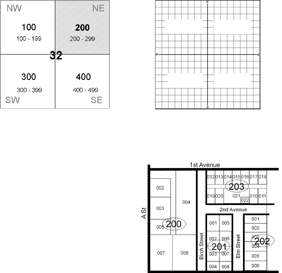
Section 32 in Capitol Township Section 32 in Capitol Township
The Lot-and-block system can be used to clearly identify properties in dense urban and
suburban areas.
The parcels shown on this plat would
be located in the Northeast (NE) quarter
of the section map (Block 200).
Blocks are numbered 100 (NW),
200 (NE), 300 (SW) and 400 (SE)
to correspond with the quarter-sections.
NW 1/4
SW 1/4
NE 1/4
SE 1/4
32

PTAX-1-M (R-04/23) Page 68
Metes and Bounds
Metes and bounds are used to describe the perimeter of property. When locating a
parcel written in a metes and bounds description, it is necessary to read the first part of
the land description portion backward to locate the point of beginning. Once the point of
beginning is determined, the metes and bounds portion of the description is read in the
order written. For example:
Commencing at the Southeast corner of the Northwest Quarter of Section 4,
Township 7 North, Range 8 East of the 3
rd
Principal Meridian, thence North 50 feet
to the point of beginning; thence West 550 feet; thence North 400 feet; thence
East 550 feet; thence South 400 feet to the point of beginning.
In locating this property, we would first locate the 3
rd
Principal Meridian, and its
governing Centralia Baseline. We would then find Range 8 East and Township 7 North.
Within that Township and Range, we would locate Section 4. We would then locate the
Northwest Quarter of that Section 4, and finally the Southeast corner of the Northwest
Quarter. The Southeast corner is the point of beginning for our metes and bounds
description. We would then read the metes and bounds description in the order written
to determine the property boundary lines. By starting at the Southeast corner and going
North 50 feet to the point of beginning; thence West 550 feet; thence North 400 feet;
thence East 550 feet; thence South 400 feet to the point of beginning, we would have
the exact location and boundary lines for our parcel.
Little Words Have Big Meanings
And, Also, and the Semi-colon (;)
When reading legal descriptions, little words have big meanings. If a fractional
description reads “NE ¼ of the NE ¼ and SE ¼ of the NE ¼, the “and” functions as a
plus sign. You add the two descriptions together. Also, and the semi-colon (;) function
as and as well. The “and” can also be found in linear and acreage legal descriptions.
“The E 160 acres and the N 80 acres of Section 16.”
“The SW ¼ of the SW ¼ and the S 40 acres of the NW ¼ of the SW ¼”.
“The NE ¼ NE ¼; NW ¼ NE ¼ also N 120 acres of the SW ¼ and SE ¼ of the NE ¼.”
PTAX-1-M (R-04/23) Page 69
Except and Excepting
When found in a legal description, the words “except” or “excepting” act as a minus
sign. The description appears before the word except and the part of the description
that follows is removed or excluded from the description. “Except” is often used when a
portion of a larger property is sold, and it provides a quick way to modify an existing
legal description as well.
“Section 16, Township 4S, Range 2 E of the 3
rd
Principal Meridian, except the SW ¼ of
the SW ¼”.
Thence
The formal definition is “from a place or source previously mentioned, especially when
you are giving directions about how to get somewhere”. Thence is often used is legal
descriptions to indicate travel from a previous point along a prescribed path.
“Commencing at the SE corner of the SE corner, thence N 70 degrees West 660 feet
to the point of beginning…”

PTAX-1-M (R-04/23) Page 70
Section Divisions and Land Measurement
1 Link = 7.92 inches = .66 feet
1 Rod = 16.5 feet
1 Chain = 66 feet = 4 rods
1 Furlong = 660 feet = 40 rods = 1,000 links
1 Mile = 8 furlongs = 320 rods =
80 chains = 5280 feet
1 Acre = 43,560 square feet
1 section = 640 acres
1/4 section = 160 acres
1/4 1/4 section = 40 acres
1/4 1/4 1/4 section = 10 acres
1/4 1/4 1/4 1/4 section = 2.5 acres
5,280 ft. = 1 mile
2,640 ft. = 1/2 mile
1,320 ft. = 1/4 mile
660 ft. = 1/8 mile
20 Chains
20 Chains
40 Chains
W ½ NW ¼
E ½ NW ¼
NW ¼ SW ¼
NE ¼ SW ¼
SW ¼ SW ¼
SE ¼ SW ¼
NE ¼
N ½ NW ¼ SE ¼
S ½ NW ¼ SE ¼
W ½
NE ¼
SE ¼
E ½
NE ¼
SE ¼
NW ¼
SW ¼
SE ¼
NE ¼
SW ¼
SE ¼
SW ¼
SW ¼
SE ¼
SE ¼
SW ¼
SE ¼
1320 Feet
1320 Feet
2640 Feet
80 Rods
2 Furlongs
20 Acres
20 Acres
20 Acres
10 Acres
5 Acres
5 Acres
5
Ac
660 Ft.
5
Ac
2 ½
Ac
10
Acres
10 Acres
10 Acres
80 Acres
80 Acres
160 Acres
40 Acres
40 Acres
40 Acres
40 Acres
160 Acres
5,280 Feet
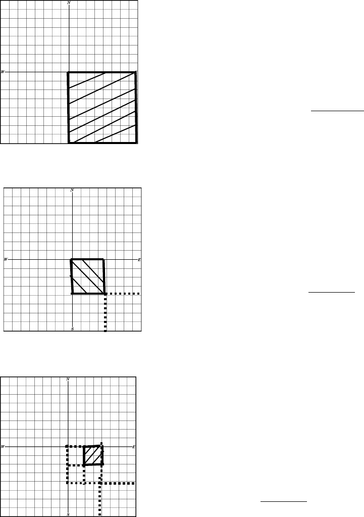
PTAX-1-M (R-04/23) Page 71
Locating Legal Descriptions by the Fractional Method
When locating legal descriptions that are fractional (NE ¼ of the NW ¼ of the SE ¼),
begin with the whole 640 acres of the section. Go to the end of the legal description for
the last part of the section. In this example, the last part mentioned is “SE ¼.” Divide
the section into 4 equal parts (since the SE ¼ is described). Each part is 160 acres
(640 acres in a section divided by 4). Now locate the SE ¼ on the grid.
SE ¼ = 640 acres ÷ 4 = 160 acres
Next, find the NW ¼ of this SE ¼.
NW ¼ of the SE ¼ =
160 acres (SE ¼) ÷ 4 = 40 acres
Now locate the NE ¼ of the NW ¼ of the SE ¼.
NE ¼ of the NW ¼ of the SE ¼ =
40 acres ÷ 4 = 10 acres
NW 1/4
SW 1/4
NE 1/4
SE 1/4
NW 1/4
NE 1/4
SW 1/4
NW 1/4
NE 1/4
SW 1/4
SE 1/4
NW 1/4
NE 1/4
SW 1/4
SE 1/4
SW 1/4
NE 1/4
NE
SE
SW
NW

PTAX-1-M (R-04/23) Page 72
The fractional method also refers to “halves” or “1/2 sections”: These can seem tricky,
but just follow the same rules by reading the description backwards.
The South ½ of the SW ¼.
Go to the SW 1/4
Then find the South ½ of that 1/4.
The Acreage method also refers to the northern, southern, eastern or western halves
or “1/2” of sections, quarter-sections, quarter-quarter sections and quarter-quarter-
quarter sections.
The same parcel above could be described as “the South 80 acres of the SW 1/4”.
It is the SW ¼ (160 acres) and the South 80 acres (½ of 160 acres).
S ½ of the
SW 1/4

PTAX-1-M (R-04/23) Page 73
Legal Descriptions with “And”
Both the fractional and acreage methods use “and” and “also” to indicate the adding
together of described property. For instance, “The E 160 acres and the NW 1/4 of the
NE ¼ of Section 16.” First, find Section 16. Then, identify the “NW ¼ of the NE ¼”.
The figure represents Section 16.
The NW ¼ of the NE ¼ would be located
here as indicated by A.
And, the E 160 acres of Section 16
would be located here as located by B
So, the entire parcel in this legal
description would be C and total
200 acres:
A
C
B

PTAX-1-M (R-04/23) Page 74
Another example using fractional descriptions E ½ of SW ¼ also the SW ¼ of SE ¼ of
Section 21.
The figure represents Section 21.
The SW ¼ of the SE ¼
AND
The E ½ of the SW ¼
40 acres + 80 acres = 120 acres total in the parcel described.
SE 1/4
SW 1/4
SE 1/4
SW 1/4
E 1/2

PTAX-1-M (R-04/23) Page 75
Unit 4, Exercise 4-1
Identify these parcels on the grid provided by shading in the appropriate parts on the
grid. Each Grid represents One Section.
1. SE ¼ of SE ¼
____________ acres
2. S ½ of NW ¼
____________ acres
3. N ½ of NE ¼ of SE ¼
____________ acres
4. E ½ of NW ¼ and NW ¼ of NW ¼
____________ acres
5. SW ¼ of SE ¼ of SW ¼
____________ acres
6. NE ¼ of NW ¼ of SW ¼
__________ acres

PTAX-1-M (R-04/23) Page 76
Legal Descriptions with Exceptions
As shown in the previous section, some legal descriptions are written combining
previously measured areas, like acreage. Fractional measurements also can be
combined, and parts can also be excepted, or not included. Refer to the following:
“A parcel described as the Northeast Quarter of the Southwest Quarter and the
Northwest Quarter of the Southeast Quarter of Section 12, Township 11 South, Range 2
West of the 3
rd
P.M.
Excepting there from the land described above as Section 12, Township 11 South,
Range 2 West of the 3
rd
P.M; the Southeast Quarter of the Northeast Quarter of the
Southwest Quarter containing 10 acres.
The parcel herein conveyed containing 70 acres, more or less.”
Note: The acreage of the parcel conveyed will be equal to the acreage in the original
parcel, minus the acreage in the exception. First draw the entire parcel and then draw
the exception.
Section 12
To begin, read the legal description
backwards which refers to Section 12.
Then find the Southeast ¼.
Then find the Northwest ¼ of that ¼.
NW 1/4
NE 1/4
SW 1/4
SE 1/4
NW 1/4

PTAX-1-M (R-04/23) Page 77
The description also says AND (reading
backwards again) the Northeast ¼ of
the Southwest ¼
Next, you will ADD the two described
sections together.
This is the original parcel described.
But, the description does not end there.
The description continues with EXCEPT:
“from the land described above”, meaning
the parcel just described, “the Southeast
Quarter of the Northeast Quarter of the
Southwest Quarter”.
Remember, reading backwards again,
begin at the SW ¼, then the NE ¼ of
that SW ¼, then the SE ¼ of that parcel
indicated by the shaded area. That is the
part of the description that is not included.
NW 1/4
NE 1/4
SW 1/4
SE 1/4
NE 1/4
NW 1/4
NE 1/4
SW 1/4
SE 1/4
NW 1/4
NE 1/4
NW 1/4
NE 1/4
SW 1/4
SE 1/4
NW 1/4
NE 1/4

PTAX-1-M (R-04/23) Page 78
So, the actual parcel described is represented
in the diagram by the shaded area.
Calculating the acreage from the description
can be done quickly by looking at the diagram
and by using the fractional measurements.
The “NW ¼ of the SE ¼” = 40 acres
The “NE ¼ of the SW ¼” = 40 acres
40 + 40 = 80 acres
EXCEPT (or minus) “The SE ¼ of the
NE ¼ of the SW ¼” or 10 acres.
80 acres – 10 acres = 70 acres total in the parcel.
NW 1/4
NE 1/4
SW 1/4
SE 1/4

PTAX-1-M (R-04/23) Page 79
Unit 4, Exercise 4-2 Legal Description with Exception
Draw the parcel and calculate the acreage.
The parcel is described as:
The SE ¼ of the SE ¼ of the NE ¼ and the NE ¼ of the NE ¼ of the SE ¼ of Section
19, Township 11 South, Range 2W.
Except the SW ¼ of the NE ¼ of the NE ¼ of the SE ¼ as described above,
The entire remaining parcel containing _______ acres, more or less.
Section 19

PTAX-1-M (R-04/23) Page 80
Unit 4, Exercise 4-3 Calculate the acreage for the following.
1. The Southeast Quarter of the Southeast Quarter of the Northwest Quarter 10 ;
and the Southwest Quarter of the Southwest Quarter of the Northeast Quarter
10 ; and the Northwest Quarter of the Northwest Quarter of the Southeast
Quarter 10 ; and the Northeast Quarter of the Northeast Quarter of the
Southwest Quarter 10 .
40 acres (Note: each ¼ ¼ ¼ = 10 acres x 4 = 40 acres in the entire parcel).
2. The East One-half of the Northeast Quarter of the Northeast Quarter of the
Southeast Quarter; and the Southeast Quarter of the Northeast Quarter of the
Southeast Quarter; and the North One-half of the Northeast Quarter of the
Southeast Quarter of the Southeast Quarter.
__________ acres
3. The South One-half of the Southwest Quarter of the Southwest Quarter; and the
South One-half of the Southeast Quarter of the Southwest Quarter; and the South
One-half of the Southwest Quarter of the Southeast Quarter; and the Northeast
Quarter of the Southwest Quarter of the Southeast Quarter; and the Northeast
Quarter of the Northwest Quarter of the Southwest Quarter of the Southeast
Quarter; and the Northwest Quarter of the Northwest Quarter of the Southwest
Quarter of the Southeast Quarter.
__________ acres
4. The Northeast Quarter of the Northeast Quarter; and the North One-half of the
Northwest Quarter of the Southeast Quarter of the Northeast Quarter; and the
Northeast Quarter of the Northeast Quarter of the Southwest Quarter of the
Northeast Quarter.
__________ acres
5.
The Southwest Quarter of the Southwest Quarter of the Northwest Quarter; and
the Northwest Quarter of the Southwest Quarter of the Northwest Quarter; and the
Southwest Quarter of the Northwest Quarter of the Northwest Quarter.
__________ acres
6. The Northwest Quarter of the Northwest Quarter of the Southeast Quarter of the
Northwest Quarter; and the Northeast Quarter of the Northeast Quarter of the
Southwest Quarter of the Northwest Quarter; and the Southeast Quarter of the
Southeast Quarter of the Northwest Quarter of the Northwest Quarter; and the
Southwest Quarter of the Southwest Quarter of the Northeast Quarter of the
Northwest Quarter. __________ acres

PTAX-1-M (R-04/23) Page 81
Locating Legal Descriptions by Acreage
When locating legal descriptions that are by acreage (W 10 acres of the NW ¼ of the
SE ¼), begin with the whole 640 acres of the section. Locate the NW ¼ of the SE ¼ as in
the previous example.
West 10 acres of the
NW ¼ of the SE ¼
The NW ¼ of the SE ¼ contains 40 acres. 640 acres ÷ 4 ÷ 4 = 40 acres. The legal
description calls for the west 10 acres of this. These 10 acres will be on the west side
of the 40 acres.
S 40 acres of NW ¼ N 20 acres of SW 1/4 E 120 acres of NE ¼

PTAX-1-M (R-04/23) Page 82
Unit 4, Exercise 4-4
Locate the following parcels on the grid.
1. The E 80 acres of the N 320 acres.
2. The N 40 acres of the E 80 acres of the NW ¼.
3. The N 40 acres of the SW ¼.
4. The S 80 acres of the SW ¼.
5. The E 20 acres of the NW ¼ of the NW ¼.
6. The S 5 acres of the SW ¼ of the SW ¼ of the SE ¼.
7. The NE 10 acres of the NW ¼ of the SE ¼.

PTAX-1-M (R-04/23) Page 83
Locating Legal Descriptions with Linear Descriptions
Refer to the Section Grid on page 70. In addition to quarter-section measurements and
acreage, the grid correlates to linear measurements.
An entire section is one-mile by one-mile square, or 5,280 ft by 5,280 ft. A quarter
section measures 2,640 feet on each side; a quarter-quarter measures 1,320 ft; a
quarter-quarter-quarter is 660 feet by 660 feet; and a quarter-quarter-quarter-quarter
measures 330 feet on each side. Looking at the grid, notice how the linear feet relate to
acreage.
5,280’
3,960’
660’
2,640’
1,320’
330’
330’
660’
1,320’
5,280’
3,960’
2,640’
10 Acres
2.5 Acres
40 Acres
160 Acres

PTAX-1-M (R-04/23) Page 84
Unit 4, Exercise 4-5
Draw the following and calculate the correct acreage
1. Beginning at the Southwest corner of Section 12, thence North 2,640 feet; thence
East 1,320 feet; thence South 2,640 feet; thence West 1,320 feet to the point of
beginning.
Section 12
This parcel contains _______ acres.
2. Beginning at the Northeast corner of Section 32, thence West 1,320 feet; thence
South 3,960 feet; thence East 990 feet; thence North 660 feet; thence East 330
feet; thence North 3,300 feet to the point of beginning.
Section 32
This parcel contains _______ acres.

PTAX-1-M (R-04/23) Page 85
Off and Off Of
Sometimes you will see “off” and “off of” in a legal description. If you read “165 ft. off of
the N. side of Section 14”, you would begin at the north side of Section 14 and
determine the distance to 165 ft. south of the northern border of Section 14. That would
be the boundary line across the entire section.
When locating legal descriptions that are described by linear measurement (E10
chains off of the NW ¼ of the SE ¼), begin with the whole 640 acres of the section.
Step 1: Locate the NW ¼ of the SE ¼.
5,280 ft.
NW ¼ of the SE ¼
which is 40 acres
Each square on this grid is 330’ by 330’.
Each square is 2 ½ acres
1 chain = 66 feet; 10 chains = 660 feet.
990 ft.
2,640 ft.
1320 ft. 1,320 ft.

PTAX-1-M (R-04/23) Page 86
Step 2: Since the legal calls for the east 10 chains, locate the east side.
Step 3: Make a horizontal line from the NE corner, of the part that has already been
identified, west 10 chains (660 feet).
Step 4: Make a horizontal line from the SE corner, of the part that has already been
identified, west 10 chains (660 feet).
Step 5: Connect the endpoints of the lines representing the 10 chains to make a rectangle.
10 chains
Step 2: East side
Step 3: NE corner of NW ¼ of the SE ¼
Step 5: Connect endpoints
Step 4: SE corner of NW ¼ of the SE ¼

PTAX-1-M (R-04/23) Page 87
Unit 4, Exercise 4-6
Using lineal land measurement description methods, please locate the following parcels
on the grid that follows, for Section 32, Township 12 South, Range 2 West, 3
rd
PM.
Refer to your template on Page 70 (or on your drafting triangle) for linear
measurements.
1. The N 10 chains off of the NW ¼.
2. The W 330 ft. off of the SW ¼ of the SE ¼.
3. 82.5 ft. off of the S side of the NW ¼.
4. The East 330 ft. off of the E ½ of the NW ¼ of the NE ¼.
Section 32 Grid Map- remember, a Section is One-Mile Square

PTAX-1-M (R-04/23) Page 88
Combined Legal Descriptions
A single legal description can be determined even if the legal contains several different
parcels. In a legal description, the appearance of the words “and” or “also” and
the semi-colon punctuation mark “;” all mean “in addition to”. If these key words or
the semi-colon appears, simply calculate the acreage for each parcel and then add the
parcels together to determine the total acreage of the property described.
Unit 4 Exercise 4-7
In this exercise, you will measure the shapes in linear feet and then convert them into
acreage. In addition, you will write the legal description describing the parcel.
Figure 1.
Section 14
Linear measurements _______ feet X ________ feet.
Acreage calculation _______________________
Legal Description “Section 14, Township 9 North, Range 1 E of the 3
rd
Principal
Meridian, __________________________________________________________
__________________________________________________________________.

PTAX-1-M (R-04/23) Page 89
Figure 2.
Section 14
Linear measurements _______ feet X ________ feet.
Acreage calculation _______________________
Legal Description “Section 14, Township 9 North, Range 1 E of the 3
rd
Principal
Meridian, ______________________________________________________________
_____________________________________________________________________.

PTAX-1-M (R-04/23) Page 90
Unit 4 Summary
Legal descriptions describe the boundary and location of property. These descriptions
can be
• land descriptions (which can be either fractional, acreage, or lineal), or
• lot-and-block descriptions,
• metes and bounds descriptions,
• or a combination of these.
When reading a legal description for purposes of locating property, read all legal
descriptions not written in metes and bounds backwards.
If the description is written in metes and bounds, read the first part of the land
description portion backward to locate the point of beginning. Once the point of
beginning is determined, the metes and bounds portion of the description is read in the
order written.
1 section = 640 acres
1/4 section = 160 acres
1/4 1/4 section = 40 acres
1/4 1/4 1/4 section = 10 acres
1/4 1/4 1/4 1/4 section = 2.5 acres
5,280 ft. = 1 mile
2,640 ft. = 1/2 mile
1,320 ft. = 1/4 mile
660 ft. = 1/8 mile

PTAX-1-M (R-04/23) Page 91
Unit 4 Review Questions
1. Locate the following on the following Section grid and calculate the acreage for each.
A. The NW ¼ D. 82.5 ft. off of the E side of the NE ¼
B. The SE ¼ of the SE ¼ E. The E 40 acres of the W 80 ac. of the NE ¼
C. The S 165 ft. off of the SW ¼ F. The North 10 chains off of the SE ¼

PTAX-1-M (R-04/23) Page 92
2. Calculate the acreage for the following.
a. The Northeast Quarter of the Northwest Quarter = ________ acres.
b. The SE 1/4 of the SE 1/4 of the SE 1/4 = ______ acres.
c. The East 1/2 of the Northwest Quarter of the Northeast Quarter = ______ acres.
3. To locate a parcel using a metes and bounds description, first read the land
description portion of the legal description _____________, and then read the metes
and bounds portion of the description in the _______________ written.
4. Read all legal descriptions not written in metes and bounds ________________.
5. Write the legal description and calculate acreage below each section map:
A. C.
B. D.
acres acres
acres
acres
PTAX-1-M (R-04/23) Page 93
6. Compute the acreage for the following parcel of land.
A part of the Southwest Quarter of Section 30, Township 11 South Range 1 East, of
the Third Principal Meridian, described as follows: Commencing at the N.W.
corner of the Southwest Quarter, thence running East 18 chains; thence running
South 8 chains; thence East
5 chains; thence South 4 chains; thence West 23
Chains; thence North 12 chains to the
point of beginning.
_________ acres, more or less.
The following pages have blank grids for additional practice.

PTAX-1-M (R-04/23) Page 94
Practice Pages
1 section = 640 acres
1/4 section = 160 acres
1/4 1/4 section = 40 acres
1/4 1/4 1/4 section = 10 acres
1/4 1/4 1/4 1/4 section = 2.5 acres
5,280 ft. = 1 mile
2,640 ft. = 1/2 mile
1,320 ft. = ¼ mile
660 ft. = 1/8 mile

PTAX-1-M (R-04/23) Page 95
Practice Page
1 section = 640 acres
1/4 section = 160 acres
1/4 1/4 section = 40 acres
1/4 1/4 1/4 section = 10 acres
1/4 1/4 1/4 1/4 section = 2.5 acres
5,280 ft. = 1 mile
2,640 ft. = 1/2 mile
1,320 ft. = ¼ mile
660 ft. = 1/8 mile

PTAX-1-M (R-04/23) Page 96
Practice Page
1 section = 640 acres
1/4 section = 160 acres
1/4 1/4 section = 40 acres
1/4 1/4 1/4 section = 10 acres
1/4 1/4 1/4 1/4 section = 2.5 acres
5,280 ft. = 1 mile
2,640 ft. = 1/2 mile
1,320 ft. = ¼ mile
660 ft. = 1/8 mile
1 section = 640 acres
1/4 section = 160 acres
1/4 1/4 section = 40 acres
1/4 1/4 1/4 section = 10 acres
1/4 1/4 1/4 1/4 section = 2.5 acres
5,280 ft. = 1 mile
2,640 ft. = 1/2 mile
1,320 ft. = ¼ mile
660 ft. = 1/8 mile
PTAX-1-M (R-04/23) Page 97
Unit 5 Metes and Bounds Legal Descriptions
Learning Objectives
After completing the assigned readings, you should be able to
• draw parcels from a metes and bounds legal description.
• understand map scale.
• use a land measure compass.
Terms and Concepts
Backsight
Bearing
Cardinal Directions
Commencing
Degree
Line
Metes and Bounds
Monuments
Point
Point of Beginning (POB)
Scale
Traverse

PTAX-1-M (R-04/23) Page 98
Introducing Your Tools
For the drawing portions of this course, training and directions will be given based on
the assumption that the tools identified below, or something similar, are being used.
Drawing legal descriptions can, however, be accomplished with other tools, such as
protractors and rulers. The following drawing tools will be supplied for you for the
exam, or you may use your own drawing tools.
Land Measure Compass
The land measure compass is designed to draw metes and bounds legal descriptions.
Drafting Triangle
The drafting triangle is a typical right-angle triangle except that it includes helpful
information. Right triangles are needed to keep parcel drawings square. In addition, the
triangle helps identify which angles are right angles.
PTAX-1-M (R-04/23) Page 99
Drafting Scale
Drafting scales come in various forms and various divisions. Depending on the size of
the parcel and the size of the paper, different scales can be used. For example, if a
parcel is to be drawn on a sheet of paper that is 8 ½ x 11, and the longest line of the
parcel is 1,320 feet, a scale of 1” =100’ could not be used because that would result in
the longest line being 13.2 inches long. Therefore, it is important to review the legal
description and determine the size of the map before selecting the scale at which the
map will be drawn.
Using your Tools
How to Convert Distances to Map Scale
As described above, it is important to understand map scale. You must convert property
line distances on the ground into the map scale on your paper to represent the line
appropriately on the map. Use a mathematical conversion in which you
Divide the Legal Description Measurement by the Map Scale.
For instance, if the paper to map scale is 1” = 100’, 1 inch on the map equals 100 feet
on the ground.
Example: Travel west for 595 feet on a map with a scale of 1” = 100’
595
÷
100 = 5.95
This means that your 595 feet long line on a map with a map scale of 1” = 100’, will equal a
line 5.95 inches long.
This method is also necessary when the map scale is different than the map scale of
your legal description. For example, historic maps were drawn at a scale of 1” = 660’.
The only way to draw legal description measurements on a map is with a ruler or scale.
So, using the conversion method above:
595 ft. ÷ 660 = .90 inches
This line on a map with a scale of 1” = 660” will be slightly less than an inch long.

PTAX-1-M (R-04/23) Page 100
Unit 5, Exercise 5-1 Map Scale Conversions
Map Scale Ground Distance Length of Line on Map
1. 1:100 330 ft. ________________
2. 1:400 2,640 ft. ________________
3. 1:600 5,280 ft. ________________
4. 1:660 5,280 ft. ________________
5. 1:660 1,320 ft. ________________
6. 1:200 675 ft. ________________
Metes and Bounds Descriptions
As discussed in the previous chapter, metes and bounds descriptions are used to
describe the perimeter of property. Beginning at a point (located using the
rectangular survey system), metes and bounds descriptions are read forwards,
traversing from point to point until the entire property has been circumscribed, returning
at the point of beginning (POB). In metes and bounds descriptions “commencing”,
“beginning at”, and “point of beginning” are all terms used to describe the starting point
for the metes and bounds description.
Within a metes and bounds description, the bearings and distances of each traverse
are listed.
A Bearing is the direction of a line measured as the acute angle from a reference
meridian.
A Traverse is the length (distance) and direction (bearing) of a line drawn between two
points.
An Acute Angle is an angle less than 90°.
Therefore, in a metes and bounds description, a typical traverse could look something
like: North 45° West, for 595 feet. Using the land measure compass, starting at North
0°, move 45° counter-clockwise, which is west. This would be the bearing. The distance
from Point A to Point B in this example is 595 feet. A traverse includes a bearing and a
distance.

PTAX-1-M (R-04/23) Page 101
Land Compass Bearings
Line up your land compass on the following diagram. The north and south arrows
should indicate 0°. The east and west arrows should indicate 90°. If a legal description
calls for a line North 45° West, you would first start with the North 0°
point on your
compass, then move along the compass to the west (your left), until you reach 45°.
Your bearing would be the line of the arrow marked NW. If a legal description calls for a
line South 45° East, you would first start with the South 0°
point on your compass. Then
move along the compass to the east (your right) until you reach 45°. Your point would
be the line of the arrow marked SE. This would be your bearing.
Note: North, South, East, West, Northeast, Northwest, Southeast, Southwest are
known as Cardinal Directions.
NW
NE
SW
SE
N
S
E
W

PTAX-1-M (R-04/23) Page 102
Describing and Measuring a Parcel
Here is a practice example in measuring a metes and bounds parcel. Remove the
following page from your packet and trace the following drawing from the Point of
Beginning and label all bearings and traverses. We will do this exercise together as a
class.
You can orient your drawing two ways:
1. Use the red vertical lines on your land compass to line up with the long edge of
your paper or
2. Use your drafting triangle and align one of the right-angle sides with the edge of
the paper to get a good horizontal reference point to align the compass
Point of Beginning
Point of Beginning

PTAX-1-M (R-04/23) Page 103
Please Remove this sheet from your binder. We will use this as a template to learn to use the
mapping tools.
Point of Beginning
PTAX-1-M (R-04/23) Page 104
PTAX-1-M (R-04/23) Page 105
Step 1: Place the land measure compass on top of the point of beginning (POB) so that
the center hole of the compass is directly over the POB and North (N) is up. Line up one
of the red vertical lines on the compass with the left-hand edge of the paper to first
orient the compass or use the two adjacent sides that make up the right angle of the
drafting triangle to orient the compass as shown on page 102.
Step 2: Move the arm on the land compass to line up exactly over the first line (that is
already labeled to North 55° East). There is a notch on the movable arm on the
compass to fit your pen or pencil in to make a dot. Make that dot.
Point of Beginning

PTAX-1-M (R-04/23) Page 106
Use your map scale 1:200 for this exercise
Step 3: Remove the land measure compass, and using a drafting scale (your ruler),
place the “0” on the POB, and line up the scale with the mark made at the N 55° E
bearing. Then follow the line that represents 700’. With a map scale of 1” = 200’, that
would be a line that is 3.5 inches long (number of feet divided by the map scale = 700/2
= 3.5 inches to Point A). Line up your drafting scale at the POB and measure 700 feet
on the 1:200 side of your scale. Mark this point with a bigger dot and label it Point A.
This line may be longer or shorter than the location of the dot you made at the end of
the moveable arm on your compass.
Step 4: It is recommended that each line should be labeled with both bearings and
distances (traverse) as it is drawn, so that if a problem is discovered the information
from the legal description is right there on the drawing. The mark you made at N 55° E
only gives the direction (bearing) of the line. The drafting scale shows the length of the
line.
The line will be labeled N 55° E 700’.
Step 5: Place the land measure compass on top of Point A, ready for the next
measurement in the legal description. At this point, it is important to be sure that the
land measure compass is oriented on the page the same way as it was when beginning
the drawing. Otherwise, even a small twist in the compass could have dramatic effects.
A
B
C
POB

PTAX-1-M (R-04/23) Page 107
To avoid this problem, backsighting is used.
A backsight is defined as “reading taken by a surveyor back toward a position from
which a previous sight has been made”. On the land measure compass, the backsight
is the opposite of the bearing previously used. Since the previous bearing was
N 55° E, the backsight is S 55° W. So, orienting the land measure compass on the map
with the center over Point A, and the line drawn matching up with S 55° W indicates that
the compass is now sitting on the page the same way as when the drawing began.
Now, with Point A in the center use your land compass to determine the degree-
measurement of the line adjoining Point A with Point B. Now measure the length of the
line. Label the line. Continue orienting the compass and backsighting from each point
and measure each line and angle and label for lines B-C & C-POB.
The measurements should be: A-B = S 68° E 475 ft.
B-C = S 71° W 1100 ft.
C-POB = N 17° E 175 ft.
If your measurements differ greatly, you may not have oriented the compass correctly!
B
A

PTAX-1-M (R-04/23) Page 108
Drawing Legal Descriptions
In the last exercise, we measured an existing parcel shape. Now you will learn how to
draw the parcel by reading the legal description
This is a practice example in drawing a metes and bounds legal description. Follow
along by tracing over the diagram using the legal description accompanying the
drawing.
Step 1: Place the land measure compass on top of the point of beginning (POB) so that
the center hole of the compass is directly over the POB and North (N) is up. Line up one
of the red vertical lines with the left-hand edge of the paper to first orient the compass or
use the two adjacent sides that make up the right angle of the triangle to orient the
compass.
Use a map scale of 1:100 for this exercise.
Point of Beginning

PTAX-1-M (R-04/23) Page 109
Step 2: Reading the first measurement of the legal description, (N 80° E, 350’), make a
mark on the paper at N 80° E. There is a notch on the movable arm on the compass to
fit your pen or pencil in to make a dot.
Step 3: Remove the land measure compass, and using a drafting scale (your ruler),
place the “0” on the POB, and line up the scale with the mark made at the N 80° E
bearing. Then draw a line that represents 350’. With a map scale of 1” =100’, that
would be a line that is 3.5 inches long (to Point A). This line may be longer or shorter
than the location of the dot you made at the end of the moveable arm on your compass.
The mark you made at N 80° E only gives the direction (bearing) of the line. The
drafting scale shows the length of the line.
Step 4: It is recommended that each line should be labeled with both bearings and
distances (traverse) as it is drawn, so that if a problem is discovered the information
from the legal description is right there on the drawing.
N 80° E bearing
Point of
Beginning

PTAX-1-M (R-04/23) Page 110
Step 5: Place the land measure compass on top of Point A, ready for the next
measurement in the legal description. The next step is to backsight.
Remember, a backsight is the opposite of the bearing previously used. Since the
previous bearing was N 80° E, the backsight is S 80° W. So, orienting the land
measure compass on the map with the center over Point A, and the line drawn
matching up with S 80
o
W indicates that the compass is now sitting on the page the
same way as when the drawing began.
Without moving the land measure compass, make a mark on the map using the
second bearing (S 45° E). This time look at due South. Make the mark that is 45° East
(counter-clockwise) of South.
Point of Beginning
Backsight of N 80° E is
S 80° W

PTAX-1-M (R-04/23) Page 111
Back sight of S 45° E is N 45° W
Steps 7 and 8
S 60° W 300’
Step 6: Remove the land measure compass, and using a drafting scale, place the “0”
mark on Point A, and line up the scale with the mark made at the S 45°E bearing. Then
draw a line that represents 250’. With a map scale of 1” =100’, that would be a line that
is 2.5 inches long (to Point B).
Step 7: Place the land measure compass on top of Point B. Backsight the previous line
to be sure the compass is oriented correctly. The previous bearing was S 45°E,
therefore the backsight is N 45°W. Turn the land measure compass until the last line
drawn lines up with N 45°W.
Step 8: Without moving the land measure compass, make a mark on the map using the
third bearing (S 60°W).
Point of
Beginning
Point of Beginning
Beginning at a point, thence N 80° E,
350’; thence S 45° E 250’; thence S 60°
W 300’; thence N 45° W, 375’ to the
point of beginning.

PTAX-1-M (R-04/23) Page 112
Step 9: Remove the land measure compass, and using a drafting scale, place the “300”
on Point B, and line up the scale with the mark made at the S 60° W bearing. Then draw
a line that represents 300’. With a map scale of 1” =100’, that would be a line that is 3.0
inches long (to Point C).
Step 10: Place the land measure compass on top of Point C. Backsight the previous
line to be sure the compass is oriented correctly. The previous bearing was S 60° W,
therefore the backsight is N 60° E. Turn the land measure compass until the last line
drawn lines up with N 60° E.
Point of Beginning
Beginning at a point, thence N 80° E,
350’; thence S 45° E 250’; thence S 60°
W 300’; thence N 45° W, 375’ to the
point of beginning.
Back sight of S 45° E is N 45° W

PTAX-1-M (R-04/23) Page 113
Step 11: Without moving the land measure compass, from Point C, mark a line on the
map using the fourth and final bearing (N 45° W).
Step 12: Remove the land measure compass, and using a drafting scale, place the
“375” on Point C, and line up the scale with the mark made at the N 45° W bearing.
Then draw a line that represents 375’. With a map scale of 1” =100’, that would be a line
that is 3.75 inches long back to the POB. (Note: if this final line does not connect with
the point of beginning, check the accuracy of each bearing and line length).
Point of Beginning
Back sight of S 60° W is N 60° E

PTAX-1-M (R-04/23) Page 114
Beginning at a point, thence N 80°
E, 350’; thence S 45° E 250’; thence
S 60° W 300’; thence N 45° W, 375’
to the point of beginning.
Back sight of S 60° W is N 60° E
Point of Beginning

PTAX-1-M (R-04/23) Page 115
For additional practice, draw a large dot on another sheet of paper at the same spot
on the page as your POB on this drawing. Use the legal description above to make a
copy. The copy should fit exactly on top of the drawing above. Other drawings will be
accomplished on the following pages.
º
Beginning at a point, thence N 80° E 350’; thence S 45° E 250’; thence S 60° W 300’;
thence N 45° W, 375’ to the point of beginning.
Point of Beginning
Point A
Point B
Point C

PTAX-1-M (R-04/23) Page 116
Unit 5, Exercise 5-2 Drawing Legal Descriptions
Remove this page from your binder to make drawing easier!
Using a scale of 1" = 100 feet, draw the following legal descriptions. The dot
represents the point of beginning for each description. Label your drawings!
1. Beginning at a point, thence N 80°E, 400'; thence S 30°E, 300'; thence
S 80°W, 300'; thence N 46°W, 350', to the point of beginning.
Place your compass on the dot below and orient the compass so that North is straight
up.
Beginning from the North on the compass, find the mark on the compass that is 80º to
the East of North and mark this place on the paper.
Now place your drafting scale on the dot below and line it up with the mark that you just
made. Draw a line from the dot along the ruler 4.0” (400 feet ÷ 100 feet = 4.0”)
Next, backsight to orient the compass. Place the compass on the end of the line you
just drew. Orient the compass so that the line you just drew is at the place on the
compass that has a bearing of 80°
Continue with the traverses. You should end up at the point of beginning.

PTAX-1-M (R-04/23) Page 117
Remove this page from your binder to make drawing easier!
2. Beginning at a point, thence N 82°E, 450'; thence S 10°W, 200'; thence S 82°W, 250';
thence N 43°W, 230' to the point of beginning.
Scale 1:100
PTAX-1-M (R-04/23) Page 118

PTAX-1-M (R-04/23) Page 119
Remove this page from your binder to make drawing easier!
3. Beginning at a point, thence S 77°E, 500' to a point; thence S 40°W, 250' to a
point; thence N 65°W, 250' to a point; thence N 29°W, 220' to the point of
beginning.
Scale 1:100
PTAX-1-M (R-04/23) Page 120

PTAX-1-M (R-04/23) Page 121
Remove this page from your binder to make drawing easier!
4. Beginning at a point, thence S 78
°
E, 425’ to a point; thence S 15
°
E,100’ to a point;
thence S 85
°
W, 550’ to a point; thence N 25
°
E,260’ to the point of beginning.
Scale 1:100
PTAX-1-M (R-04/23) Page 122

PTAX-1-M (R-04/23) Page 123
Remove this page from your binder to make drawing easier!
5. Beginning at a point, thence N 23
°
E, 175’ to a point; thence N 68
°
E, 350’ to a
point; thence N 88
°
E, 150’ to a point; thence S 32
°
E, 250’ to a point; thence S 53
°
W, 150’ to a point; thence N 67
°
W, 150’ to a point; thence S 80
°
W, 420’ to the
point of beginning.
Scale 1:100
PTAX-1-M (R-04/23) Page 124
PTAX-1-M (R-04/23) Page 125
Extra Practice for Over-Achievers!
Use the Blank Page following to complete the drawing
6. Using a scale of 1" = 200', please draw the following legal description and calculate
the total acreage.
Note that in this legal description “Commencing at” leads you to the point of
beginning.
Commencing at the Northwest corner of Section 6, Township 11 South, Range 2 West
of the 3rd Principal Meridian, thence East along the Section line 460 feet to the point of
beginning. Thence continue East 90
o
, 200 feet to a point; thence S 0
o
, 45 feet to a
point; thence East 90
o
, 50 feet to a point; thence S 0
o
, 40 feet to a point; thence W 90
o
,
110 feet to a point thence S 0
o
, 815 feet; thence N 38
o
W, 105 feet to a point; thence W
90
o
, 40 feet to a point; thence S 0
o
, 30 feet to a point; thence W 90
o
, 35 feet to a point;
thence S 0
o
, 50 feet to a point; thence W 90
o
, 150 feet to a point; thence N 0
o
, 180 feet
to a point; S 40
o
W, 235 feet to a point; thence W 90
o
, 45 feet to a point; thence N 0
o
,
470 feet to a point; thence E 90
o
, 195 feet to a point; thence N 58
o
W, 225 feet to a
point; thence N 0
o
, 80 feet to a point; thence E 90
o
, 195 feet to a point; thence N 0
o
,
145 feet to a point; thence N 70
o
E, 160 feet to a point; thence N 0
o
, 45 feet to the point
of beginning
PTAX-1-M (R-04/23) Page 126

PTAX-1-M (R-04/23) Page 127
Drawing for Over-Achievers!
Northwest Corner
PTAX-1-M (R-04/23) Page 128
Unit 5 Summary
Various tools are of assistance when drawing metes and bounds descriptions. Since
many descriptions are given in bearings and distances of each traverse listed, it is
necessary to have some type of compass to measure the bearings or degree of angles.
A right triangle is helpful to keep parcel drawings square as well as to identify right
angles when calculating the area of a right triangle.
A ruler or drafting scale is also a needed instrument to measure the distances.
When drawing out legal descriptions, it is important to understand map scale. To
convert property line distances into map scale to represent the line appropriately on the
map, divide the legal description measurement by the map scale. If the paper to map
scale is 1”-100’, then 1 inch on the map equals 100 feet on the ground.
A bearing is the direction of a line measured as the acute angle from a reference
meridian.
A traverse is the distance traveled.
POB = Point of Beginning
A properly measured parcel drawn by outlining the boundary should “close”, meaning
the point of beginning and the end point should meet.

PTAX-1-M (R-04/23) Page 129
Unit 5 Review
1. Conversion- Draw the following legal description and calculate acreage.
Use your 1:400 scale.
Beginning at the Northwest corner of the Southwest Quarter of Section 12,
Township 8 North, Range 3 West of the Third Principal Meridian; thence East 2
Furlongs; thence South 6 rods; thence East 2 chains, 1 rod; thence South 26
degrees East 990 feet, thence West 2 furlongs, 34 rods; thence North 1000 feet to
the point of beginning, containing ___________ acres, more or less.

PTAX-1-M (R-04/23) Page 130
2. Please draw and compute the acreage for the Harper parcel. Use the Scale
1” = 100’ and complete your drawing below.
Beginning at the SW corner of the SE ¼ of the NE ¼ of Section 27, Township 12
South, Range 2 West of the 3
rd
PM, thence N 275 feet to a white pine tree, thence
East 38 feet to a stone, thence S 50 feet to a fence post at the corner of the Brown
farm, thence E 200 feet to a maple tree 2 inches in diameter, thence S 28º E 250
feet to a Wahoo, thence W 350 feet to the point of beginning, containing _______
acres, more or less.
PTAX-1-M (R-04/23) Page 131
Unit 6 Assigning a Property Index Number (PIN)
Learning Objectives
After completing the assigned readings, you should be able to
• locate real property using a PIN.
• create a PIN.
• follow a series of property sales.
Terms and Concepts
Description
Section
Parcel
Section Number
Property Index Number (PIN)
Subdivision
Range
Township
Lot and Block
PTAX-1-M (R-04/23) Page 132
The Property Index Number
A Property Index Number (PIN) is another form of a legal description. This is since, just
like a written legal description, a PIN identifies one specific parcel. If a parcel splits, the
description of the original and new parcel changes. Therefore, the PIN must also change.
There are principles for assigning PIN numbers. When used consistently throughout the
county, finding a parcel based on a PIN is equivalent to using a written legal description.
When assigning PINs, these principles apply:
1. A change of ownership without any change in property boundaries does not
necessitate a new parcel number. As long as the boundary of the property does not
change, like a written legal description, the PIN does not change either.
2. Parcel splits require the original number to be retired. The original owner (grantor)
would be assigned the next available number, and the new owner (grantee) would
be assigned the next number after that assignment.
3. Once a parcel number is placed on the assessment roll, it becomes a legal
description. Consequently, as stated above, when the boundaries of a parcel are
changed, the resulting parcel must have a new number assigned to denote the new
legal description.
4. Block numbers are assigned according to the lowest numbered block in which a
person owns property. (Block numbers will be discussed in the following pages.)
5. A PIN is a 14-character series of numbers that describe the geographic location
and use of a specific tax parcel. No two parcels share the same PIN.
Example 07 – 32 – 203 – 021 – 0040
07 = County Township Number
32 = Township Section Number
203 = Block Number
021 = Parcel Number
0040 = Use or Unit Number

PTAX-1-M (R-04/23) Page 133
County Township Number Derivation
The Congressional Township and Range numbers used in the Rectangular Survey
System (T21S, R14W, etc.) are impractical for use in the County PIN due to the fact that
it is alpha-numeric and is from 6-8 characters long. Therefore, each county uses a
standard County Township number of 2 digits (01-99) as the first two digits of the PIN.
The County Township Number is assigned by overlaying the government survey
townships over the county. Beginning in the northwest government survey township of
the county, and progressing west to east, then north to south each township is assigned
a number.
No matter how small an area of the county in the government survey township, it
receives a number. Additionally, the government survey townships do not necessarily
correspond to the political townships created with the county.
In this example, there are 15 County Townships. Referring to the example PIN, the
County Township is number “07” as highlighted below. The first and second digits in the
property index number indicate the county township in which the parcel is located.
1
5
8
9
10
11
12
13
14
15
7
2
3
4
6
County Township
07

PTAX-1-M (R-04/23) Page 134
Section Number Derivation
The numbering of sections begins in the northeast corner of the township, and
progresses west then east, back and forth in a serpentine manner.
Referring back to the example PIN on page 132, Section “32” is indicated. The third
and fourth digits in the property index number indicate the section in which the parcel is
located.
Section Number
07
32

PTAX-1-M (R-04/23) Page 135
Block Number Derivation
The Block Number refers to the quarter section within the section. The numbering
of the blocks begins in the northwest quarter of the section, and progresses west to
east, north to south. As illustrated above, property in the northwest quarter of the
section would receive a block number between 100 and 199; the northeast quarter
200 to 299; the southwest quarter 300 to 399 and the southeast quarter 400 to 499.
The specific number is dependent upon any subdivisions with the quarter section. The
subdivision numbers are typically assigned in order of creation. However, this varies
within each county.
Referring back to the example PIN, Block Number “203” is indicated, meaning the
northeast quarter. The 5
th
, 6
th
and 7
th
digits of the property index number indicate the
block (in the quarter section) in which the parcel is located.
Block Number
07
32
203

PTAX-1-M (R-04/23) Page 136
Parcel Number Derivation
The Parcel Number is unique to the property within a Block. Typically, Parcel Numbers
are assigned in the order of creation.
Referring back to the example PIN on page 132, Parcel Number “021” is indicated. The
8
th
, 9
th
and 10
th
digits of the property index number indicate the legal description within
the quarter section in which the parcel is located.
07
32
203
021
Parcel Number

PTAX-1-M (R-04/23) Page 137
Unit Number Derivation
The Unit or Use Number refers to the taxable use of the property, or in the case of
condominiums, the unit number.
Referring to the example PIN above, the Use Number “0040” is indicated. The “0040”
refers to a residential parcel, with a dwelling. The 11
th
, 12
th
, 13
th
and 14
th
digits of the
property index number indicate the use of the property.
Common Use/Unit numbers:
0010 Rural property improved with buildings. Not assessed under the Farm Bill.
0011 Rural property improved with buildings. Assessed under the Farm Bill.
0020 Rural property not improved with buildings. Not assessed under the Farm
Bill
0021 Rural property not improved with buildings. Assessed under the Farm Bill
0030 Residential vacant land
0040 Residential with dwelling
0050 Commercial residence – 6 units or more
0060 Commercial business
0070 Commercial office
0080 Industrial
0090 Miscellaneous
The PIN number has 14 digits. The first 10 digits refer to the geographical location and
the last 4 digits refer to the use of the property.
Unit Number
07
32
021
0040
203
PTAX-1-M (R-04/23) Page 138
Rules for PIN Progression Summarized:
• A change of ownership without any change in property boundaries does not
necessitate a new PIN.
• Parcel splits require the original number to be retired. The original owner
(grantor) would be assigned the next available number, and the new owner
(grantee) would be assigned the next number after that assignment.
• The County Township Number and Section number will not change based on
ownership change of a parcel.
• The Block number is assigned based on the first block of the section in which the
owner owns property.
• The Parcel number is unique within a block. Parcels can be created by splits and
additional property development and their numbers can also be retired.
• The last 4 digits of the PIN can indicate Use and or Unit number. If a parcel’s use
changes, like from farmland to residential, the PIN should change as well.
Example A: Homeowner Smith sells his house and land to Homeowner Jones. Smith’s
PIN is 21-32-402-0025-0040. What is Jones’ new PIN?
Answer: The PIN is the same-no property boundaries have changed.
Example B: Farmer Brown sells off 5 acres of an entire section of farmland he owns to
Businessman Boyd, so Boyd can build his new home. Brown’s original PIN is 02-15-
100-0001-0011. What are the new PIN’s?
Answer: Farmer Brown’s original PIN will be retired, and he will get the next available
PIN. The only number position that will change will be the parcel number, 0001.
Businessman Boyd’s new number would be the next available number after that.
Depending on where the new parcel is located in the section, the numbers that could
change would be the block number (1
st
block in which the owner owns property; the
parcel number (next available); and use number (from farmland 0011 to residential 0040
once the home is built).
Example C: Developer Dawes builds a duplex. The PIN is 03-31-300-0007-0040. He
sells one side and lives in the other. What are the new PINS?
Answer: The original PIN is retired, Dawes gets the next available PIN in which the
parcel number and use code (if unit number is used) change. The new buyer of the
other side of the duplex gets the next available PIN after that.

PTAX-1-M (R-04/23) Page 139
Unit 6 Exercise 6-1
The goal of this exercise is to understand how to identify the correct PIN for
parcels that are created when portions of the original parcel are sold. For this
exercise, the original parcel is the entire section (640 acres). The County
Township Number shall be ‘01’.
Using the map (grid) of Section 26 provided next to each transaction, identify the PINs
for the following real estate transactions. Section 26 is the Rectangular Land Survey
section number while the “01” in the PIN refers to the first township in the NW
corner of the county. As the transactions are completed, it is recommended that the
areas of Section 26 are shaded in to assist with tracking the property associated with
the original PIN. The use for the property will be “0021” designating “farmland.
Transaction "A": Section 26
Grantor: Thomas and Judy Bates
Grantee: Richard and Rebecca Heart
Date: November 25, 1984
Legal: Section 26, Twp. 4S, Range 3 West, 3
rd
PM
(640 acres)
Original PIN 01-26-100-001-0021
(A) 01- 26- 100- 001-0021 (Heart Tract)
Since the Grantor owns all 640 acres of Section 26, the block number is 100, because
remember block number is determined by the first block of the section in which you own
property. Since he has all 640 acres, the parcel number will also be the first, or 001. The
use is 0021 as given in the description. Conveying the parcel will not change the PIN
Transaction "B": Section 26
Grantor: Richard and Rebecca Heart
Grantee: Thomas Johnson
Date: April 17, 1989
Legal: The SW ¼ of Section 26, T 4S, R 3W, 3
rd
PM
(160 acres)
01-26-100-002-0021 (Heart Tract)
(B) 01-26-300-001-0021 (Johnson Tract)
A
A
B

PTAX-1-M (R-04/23) Page 140
Both parcel numbers will change here because now Heart does not own all of the
property in Section 26. Heart gets the next available parcel number in the sequence and
the original PIN is retired. The next number would be 01-26-100-002-0021.
So now Johnson owns property in Section 26 of the same township (01). And the first
block in which he owns property is in the 300 block. He owns the one and only parcel in
the 300 block, so his block number is 300 and his parcel number is 001. The use code
remains 0021 for farmland. The Johnson tract is now
01-26-300-001-0021
Transaction "C": Section 26
Grantor: Richard and Rebecca Heart
Grantee: Christopher Freeman
Date: February 7, 1990
Legal The NE 1/4 of the NE 1/4 of Section 26,
T 4S. R 3W, 3
rd
PM
(40 acres)
01-26-100 003-0021 (Heart Tract)
(C) 01-26-200-001-0021 (Freeman Tract)
The Grantor, Heart, is still conveying property. The NE ¼ of the NE ¼ now goes to
Freeman. The Johnson property (B) has no boundary line changes, so its PIN remains
the same. The Heart track does have a boundary change, which means its PIN must
change, too. Heart gets the next available parcel number in the sequence and the
original PIN is retired. The next available PIN is 01-26-100 003-0021.
The newcomer, Freeman, has his first property in the Section in the 200 block, so he
will get a new PIN of 01-26-200-001-0021
Transaction "D": Section 26
Grantor: Richard and Rebecca Heart
Grantee: John and Mary Carter
Date: March 4, 1990
Legal Description: The NW 1/4 of the NW 1/4 of
Section 26, Twp. 4S, Range 3 West, 3
rd
PM
(40 acres)
01-26-100-004-0021 (Heart Tract)
B
A
C
B
C
D
A

PTAX-1-M (R-04/23) Page 141
(D) 01-26-100-005-0021 (Carter Tract)
For this conveyance, only the new buyer, Carter, and the Hearts will have changes to
their boundaries. Heart will again have to retire his PIN and get the next in line. Their
first property owned is still in the 100 block, so the block number would remain the
same, but the parcel number would change. That would be 01-26-100-004-0021. Now
Carter also owns property in the 100 block (or Northwest Quarter). So, he gets the next
available number after Heart’s new number. 01-26-100-005-0021
Solve for the following conveyances. Indicate the new parcel on the map.
Transaction "E": Section 26
Grantor: Richard and Rebecca Heart
Grantee: Thomas Jones
Date: April 1, 1990
Legal Description: The SW 1/4 of the NW 1/4 of
Section 26, Twp. 4S Range 3 West, 3
rd
PM
(40 Acres)
01-____________________ (Heart Tract)
(E) 01-____________________ (Jones Tract)
Transaction "F":
Section 26
Grantor: Richard and Rebecca Heart
Grantee: Mike and Christine Weber
Date: June 1, 1991
Legal Description: The NE 1/4 of the NW 1/4 and
the SE 1/4 of the NW 1/4 of Section 26, T 4S.,
R 3W, 3
rd
PM
(80 acres)
01-_______________________ (Heart Tract)
(F) 01-_______________________(Weber Tract)
B
C
D
A
B
C
D
A
PTAX-1-M (R-04/23) Page 142
Unit 6 Exercise 6-2
On the section map that follows on Page 145, identify the PINs for the following
real estate transactions and calculate the acreage for each. For the purposes of this
exercise, the township number has been provided.
Real Estate Transaction "A"
Deed Record 104, page 570
Grantor: Larry L. Davis
Grantee: Patrick D. and Rebecca J. Joseph
Date: May 9, 1988
Legal Description: The Northeast Quarter; and the Northwest Quarter; and the Southeast
Quarter; and the Southwest Quarter being all of Section 36, Township 8 South, Range 1
East of the Third Principal Meridian.
Containing _______ acres, more or less. PIN: 08-__________________ (Joseph tract)
Real Estate Transaction "B"
Deed Record 108, page 669
Grantor: Patrick D. and Rebecca J. Joseph
Grantee: James Harris
Date: February 14, 1989
Legal Description: The South 1320’ of the entire NW 1/4, Section 36, Township 8 South,
Range 1 East of the Third Principal Meridian.
Containing _______ acres, more or less
PIN: 08-_____________________________ (Joseph tract)
PIN: 08-_____________________________ (Harris tract)
Real Estate Transaction "C"
Deed Record 110, page 238
Grantor: Patrick D. and Rebecca J. Joseph
Grantee: Thomas Davis
Date: May 12, 1989
Legal Description: Beginning at the Southwest corner of Section 36, Township 8 South,
Range 1 East of the Third Principal Meridian, thence North 2,640’ to a point, thence East
2,640’ to a point, thence South 2,640’ to a point, thence West 2,640’ to the point of beginning.
PTAX-1-M (R-04/23) Page 143
Containing _______ acres, more or less.
PIN: 08-_____________________________ (Joseph tract)
PIN: 08-_____________________________ (Davis tract)
Real Estate Transaction "D"
Book 150, page 222
Grantor: Patrick D. and Rebecca J. Joseph
Grantee: Richard Charles
Date: May 25, 1989
Legal Description: Beginning at the Northwest corner of Section 36, Township 8 South,
Range 1 East of the Third Principal Meridian, thence South 1320’ to a point; thence
East 1320’ to a point; thence North 1,320’ to a point; thence West 1320’ to the
point of beginning. Also, the NE 1/4 of the NW 1/4 of Section 36.
Containing _______ acres, more or less.
PIN: 08-_____________________________ (Joseph tract)
PIN: 08-_____________________________ (Charles tract)
Real Estate Transaction "E"
Deed Record 310, page 339
Grantor: Patrick D. and Rebecca J. Joseph
Grantee: Gary Hardy
Date: November 25, 1989
Legal Description: South 1/2 of the West 1/2 of the SW 1/4 of the SE ¼ of Section 36,
Township 8 South, Range 1 East of the Third Principal Meridian
Containing _______ acres, more or less.
PIN: 08-_____________________________ (Joseph tract)
PIN: 08-_____________________________ (Hardy tract)
How many acres remain in the Joseph parcel? ______________________ acres.
PTAX-1-M (R-04/23) Page 144

PTAX-1-M (R-04/23) Page 145
Unit 6, Exercise 6-2 Drawing (draw parcels all on one grid)
PTAX-1-M (R-04/23) Page 146
PTAX-1-M (R-04/23) Page 147
Unit 6 Summary
A PIN is a 14-character series of numbers that describe the geographic location and
use of a specific tax parcel. No two parcels share the same PIN.
There are principles for assigning PIN numbers. When used consistently throughout the
county, finding a parcel based on a PIN is equivalent to using a written legal description.
When assigning PINs, these principles apply:
• A change of ownership without any change in property boundaries does not
necessitate a new PIN nor a new legal description.
• A PIN can be a legal description of property.
• Parcel splits require the original number to be retired. The original owner
(grantor) would be assigned the next available number, and the new owner
(grantee) would be assigned the next number after that assignment.
• Once a parcel number is placed on the assessment roll, it becomes a legal
description. Consequently, as stated above, when the boundaries of a parcel
are changed, the resulting parcel must have a new number assigned to denote
the new legal description.
• Block numbers are assigned according to the lowest numbered block in which a
person owns property.
• The Parcel number is unique within a block. Parcels can be created by splits and
additional property development and their numbers can also be retired.
• The last 4 digits of the PIN can indicate Use and or Unit number. If a parcel’s use
changes, like from farmland to residential, the PIN should change as well.

PTAX-1-M (R-04/23) Page 148
Unit 6 Review Questions
Draw the property described on the following sheet and record the PINS for each
property and calculate the acreage. Scale 1:660
Mikey Moose owns the property described as all of Section 16.
The PIN is 01-16-100-001-0020
Mr. Moose decides to convey the following to Duffy Duck:
(A) Moose to Duck
Legal….SE1/4 of the NE1/4 of the SE ¼ of the NW ¼
________Acres, more or less.
Moose PIN _____________________
Duck PIN_______________________
Now Mr. Moose decides to convey some property to Froghorn Leaphorn.
(B) Moose to Leaphorn
Legal…SE ¼ of the NE ¼ of the NE ¼ of the NE ¼
_______Acres, more or less
Moose PIN____________________
Leaphorn PIN__________________
Once again, Mikey Moose conveys some property to Why Lee Coyote.
(C) Legal…. S ½ of the NE ¼ and the NW ¼ of the NE ¼ of the SE ¼.
_______Acres, more or less
Moose PIN___________________
Coyote PIN___________________
Finally, Mr. Moose makes a new friend, Tweety Byrd, and decides to convey to her:
(D) Legal…. From the point of the SW corner of Section 16, traverse East 1155
feet to the POB. Thence North 330’, thence E 165 feet, thence South 330
feet, thence West 165 feet.
_________Acres, more or less.
Moose PIN____________________
Byrd PIN______________________

PTAX-1-M (R-04/23) Page 149
Unit 6, Review Questions The Property of Mr. Mikey Moose, Section 16
Scale 1:660
Section 16 PIN 01-16-100-001-0020
PTAX-1-M (R-04/23) Page 150
PTAX-1-M (R-04/23) Page 151
Unit 7 GIS and Mapping
This unit covers the use of GIS in mapping and assessing property.
The purpose of this unit is to provide an understanding of how computers and a GIS are
used in modern mapping.
Learning Objectives
After completing the assigned readings, you should be able to
• explain the benefits of using computerized data.
• define GIS and GPS.
• understand the uses of a GIS.
Terms and Concepts
Geographic Information System (GIS)
Global Positioning System (GPS)
Vector Data
Raster Data
Attributes

PTAX-1-M (R-04/23) Page 152
GPS Technology Makes GIS Maps a Reality
Maps historically were drawn, photographed, and measured “by hand”. Satellite
technology that we use every day on our phones, in our cars, and on our jobs is
provided by GPS technology. But what really is GPS?
GPS is the Global Positioning System owned by the U.S. government. It is a utility
comprised of a constellation of satellites flown into space and controlled by the U.S. Air
Force. As of the writing of this manual, there are currently 31 satellites in the GPS
constellation which transmit radio signals to users. The satellites circle the Earth two
times per day. Data that is collected by the satellites can be used in local GIS mapping
systems.
GPS supports the accurate mapping and modeling of the physical world — from
mountains and rivers to streets and buildings to utility lines and other resources.
Features measured with GPS can be displayed on maps and in geographic information
systems (GIS).
Computerized Mapping
Geographic Information System (GIS)
A Geographic Information System is a system designed to capture, store, manipulate,
analyze, manage and present spatial or geographic data.
The property tax assessor can use GIS as another tool to provide fair and equitable
property tax assessments.
GIS allows the assessor to view, understand and visualize data in many ways that can
reveal relationships, patterns and trends in the form of maps, reports and charts. Its
main strength lies in allowing the user to view data to select, sort, list, group, report and
print data by a wide variety of criteria.
GIS was developed for spatial analysis needs such as planning, natural resources, and
land records management. It offers the ability to integrate spatial data (map layers) and
attribute data (information from a database) among different layers, which makes it ideal
for multi-purpose users.
Each layer in the GIS can be compared to a single map overlay. For example,
planimetric features such as bodies of water, soil types, geologic structure, land use,
zoning, political boundaries, utilities, sewers, topography, property lines, and others can
be overlaid.
Especially noteworthy are the GIS systems that can provide past and present polygon
changes (outline of a home or property) to help detect new improvements or previously
undetected improvements.

PTAX-1-M (R-04/23) Page 153
The photo on the left is 1 year old. The GIS flagged this photo on the right as a property
that may have changed. The new polygon overlay indicates a large addition to the
structure.
Previous Current
Previous Current
Looks like a new pool and patio as well as a second story addition-note the changes to
the roofline…

PTAX-1-M (R-04/23) Page 154
Data and Mapping Systems
GIS data represent real objects (such as roads, houses, trees, elevation, etc.) with
digital data determining the mix. Real objects can be divided into two forms-discrete
objects, (like a building); and continuous field (like elevations) and can be stored as
raster images and vector images. GIS vector data appear on the map as a specific
type of shape which can either be a point, line or polygon (area). Each map layer is a
collection of these points, lines or polygons.
Each feature (a single point, line or polygon) in a GIS has a geographic or “shape”
component and a tabular “attribute” component. The geographic component is the
visual part that appears on the map and is tied to a location on the earth. The attribute
component contains a record of information such as name, parcel identification
number, block number and parcel address.
The tabular component supports relationships with other tables by using traditional
database linked key fields. However, a GIS “geodatabase” supports spatial, or location,
relationships as well. It is this geographic location aspect that makes GIS data appear in
the correct location on the map in relation to other data.
PTAX-1-M (R-04/23) Page 155
The visualization of the data helps to find answers to important questions relating to
“Place”.
• Where are these addresses or parcel numbers?
• What is near the place of interest?
• How large is the parcel?
• What else could be influencing this site?
Other GIS Technology
Assessors have even newer and less expensive tools at their fingertips with the advent
of the smart phone. Besides regular software programs that can be installed on an
office PC, phone applications, or “apps”, are available for assessors, realtors, property
buyers and surveyors to use on their phones. This technology can locate and draw legal
descriptions.
For instance, there are apps for both iPhones and android phones that can be
downloaded for free or as little as five dollars that can translate the coordinates of a
metes and bounds description to a closed drawing. If the user does not know actual GIS
coordinates, some of these apps allow the user to bring in the coordinates to their
phone while visiting the subject property.
These apps can be used in finding errors and discrepancies in deeds and legal
descriptions. Sometimes, linear measurements are incorrect, directions are wrong, and
size calculation errors often occur. As use of these products increases and errors are
corrected, the data quality overall will increase, hopefully making the assessors’ jobs
easier.
GIS Benefits for Assessors, Township and County Offices
Digital technology is one of the greatest enhancements for mapping in recent history.
Some advantages of using computers in a modern mapping program are speed,
precision, flexibility, productivity, display capabilities, storage and retrieval efficiencies,
and improved correction of errors and omissions. Another notable advantage is ease of
providing updates, and elimination of shrinkage or quality deterioration of base material
(transparency and paper) over time.
PTAX-1-M (R-04/23) Page 156
Summary of benefits of computerized data vs. hard copy data
• easy to share
• takes less space
• preserves information
• inventories information
• analyzes information
• organizes information
• displays information
If an office does not already use a GIS mapping system, use of these systems can
provide many benefits by dramatically reducing time and expense of field assessments.
It can also increase revenue by allowing the assessor to discover previously undetected
improvements. Other benefits include:
• determining changes based on polygonal shape overlays.
• identifying changes more quickly.
• saving on staffing, vehicle and fuel costs.
• providing access to gated, uninhabited, and other hard-to-reach structures.
• finding new improvement quickly in areas where no permits are used or not
applied for (often farms).
• providing a solution to restrictions against traveling between farms due to risk of
spreading bacteria or disease.
• improving map maintenance to most current version.
• overlaying layers of data.
Often, costs and use can be shared with other entities, like police, fire, and the public.
Additionally, use of a GIS mapping system can help improve communications in the
assessment office by
• using images during the appeal process.
• easing complaint resolution at protest time.
• reducing confrontations from property owners when images can be discussed
face-to-face.
• reducing time for complaint resolution by eliminating many field inspections.
PTAX-1-M (R-04/23) Page 157
PTAX-1-M (R-04/23) Page 158
Unit 7 Summary
GIS vector data appear as basic points, lines, and polygons (enclosed areas) that make
up the features of a map.
GIS refers to geographic information system.
GPS refers to the Global Positioning System owned by the U.S. government.
There are many benefits to providing assessors with tools to help them make fair and
equitable assessments.
PTAX-1-M (R-04/23) Page 159
Unit 7 Review Questions
1. Define GIS
_______________________________________________________________
_______________________________________________________________
_______________________________________________________________.
2. What are three benefits of GIS for assessors?
_______________________________________________________________
_______________________________________________________________
_______________________________________________________________
_______________________________________________________________.
3. Define GIS Vector data.
_______________________________________________________________
_______________________________________________________________
PTAX-1-M (R-04/23) Page 160
Examination Information and Prep
• The exam consists of 50 multiple choice questions.
• Each question is worth an equal number of points when the exam is graded.
• There is only one best answer for each question on the examination.
• Two hours are allotted for completion of the exam.
• The exam is closed book. All class materials, papers, computers, and cellular
devices must be removed from the table before taking the exam.
• Cellular phones may not be used as calculators.
Test-Taking Strategies
• Read each question thoroughly and choose the one best answer provided.
• Review the answer sheet for any skipped answers or multiple answers for the
same question.
• Tips for taking a multiple-choice exam:
o Some test-takers prefer to answer questions that they are confident in the
answers first and choose to skip over harder questions or questions that
involve math calculations. If this is done, be sure to complete the correct
answer on the answer sheet for the questions being answered. The
answer sheets are graded by hand, so question numbers may be circled
so that they can be easily identified during the second pass through the
exam.
o Be mindful of the time allotted. If a question is taking a lot of time to
answer, move past it and come back to it later.
o Guessing an answer is better than leaving it blank if time becomes an
issue.
PTAX-1-M (R-04/23) Page 161
Course Answer Key

PTAX-1-M (R-04/23) Page 162
Unit 1 Review Answers
1. What is an aerial mosaic map? An assembly of aerial photographs to
form a continuous photographic representation of a portion of the
Earth’s surface.
2. What is a topographic map? A map which represents the horizontal and
vertical position of the land features.
3. What is a cadastral map? A map that shows the size, shape, and extent
of each land parcel for purposes of describing and recording
ownership.
4. What is the recommended scale for an urban aerial-based tax map?
1” = 100’
5. What is the recommended scale for a rural aerial-based tax map?
1” = 400’
6. What are the basic functions of maps?
1. Location
2. Identification
3. Inventory
7. A Soil Survey Map has 3 sets of alphanumeric characters which indicate
what features of the soil (in order):
Soil Type Slope Erosion

PTAX-1-M (R-04/23) Page 163
Unit 2, Exercise 2-1 Answers
Parcel shape Measurements Square Footage Acreage
1. Square 1,528 ft. x 1,528 ft.
2. Square 680 ft. each side
3. Rectangle 1,250 ft. x 1,000 ft.
4. Rectangle 125 ft. x 75 ft.
5. Square 65 ch. x 65 ch.
6. Rectangle 30 ch. x 48 ch.
7. Triangle 475 ft. x 986 ft.
8. Triangle 680 ft. x 360 ft.
9. Triangle 22 ch. x 48 ch.
10. Triangle 38 ch. x 46 ch.
11. Square 5 rds. x 5 rds.
1 rd. = 16.5 ft. 82.5 ft. x 82.5 ft.
12. Rectangle 5 rds. x 7 rds.
1 rd. = 16.5 ft. 82.5 ft. x 115.5 ft.
13. Rectangle 200 lks. x 300 lks.
1 lk. = .66 ft. 132 ft. x 198 ft.
14. Square (8 chains, 3 rods, 16 links)
2,334,784
462,400
10.62
1,250,000
28.70
9,375
.22
18,404,100
422.50
6,272,640
144.00
234,175
5.38
53.60
2.81
2,299,968
52.80
3,807,144
87.40
6,806
.16
9,529
.
22
26,136
345,815
7.94
1 ch. = 66 ft. 4,290 ft. x 4,290 ft.
1 ch. = 66 ft. 1,980 ft. x 3,168 ft.
468,350 sq. ft. / 2
680 ft. x 360 ft. = 244,800 sq. ft. / 2
1,452 ft. x 3,168 ft. = 4,599,936 sq. ft. / 2
2,508 ft. x 3,036 ft. = 7,614,288 sq. ft. / 2
122,400
.
60

PTAX-1-M (R-04/23) Page 164
Unit 2 Review Answers (round SF and carry Acreage to 2 decimal pts)
Parcel shape Measurements Square Footage Acreage
1. Square 1,742 ft. x 1,742 ft. 3,034,564 69.66
2. Rectangle 165 ft. x 95 ft. 15,675 .36
3. Square 82 ch. x 82 ch. 29,289,744 672.40
(5,412’ x 5,412’)
4. Triangle 720 ft. x 490 ft. 176,400 4.05
5. Triangle 27 ch. x 36 ch. 2,117,016 48.60
6. Rectangle 9 rds. x 6 rds. 14,702 .34
7. Rectangle 500 lks. x 38 rds. 206,910 4.75
8. Square (6 chains, 2 rods, 23 links) 197,296 4.53
396 + 33 + 15.18 = 444.18 X 444.18 = 197,296
9. Calculate the square footage and the acreage for the following:
Note that the figure is the same on the right side as on the left side.
225 ft.
A = 2,500 100 ft.
B = 12,500
C
= 2,500
17,500 125 ft.
Square footage 17,500 Acreage .40
2,500
12,500
50 ft.
50 ft.
125
100 ft.
A
C
B

PTAX-1-M (R-04/23) Page 165
10. Calculate the square footage and acreage for the following parcel.
A = 50 x 100 = 2,500 SF
2
B = 150 x 100 = 15,000 SF
C = 75 x 100 = 3,750 SF
2
D = 75 x 50 = + 3,750 SF__
= 25,000 SF/ 43,560 = .57 acres
Square footage = 25,000 Acreage = .57
150’
75’
200’
50’
150’
50’
100’
100’
A
B
C
D

PTAX-1-M (R-04/23) Page 166
Unit 3, Exercise 3-1 Answers
Locating Townships and Sections
Locate the following and place the appropriate letter in the proper location:
A. Township 2 North, Range 4 East
B. Township 4 South, Range 2 West
C. Township 3 North, Range 2 West
D. Township 1 South, Range 3 East
E. Section 16, Township 2 North, Range 4 West
F. Section 1, Township 2 North, Range 4 West
G. Section 36, Township 2 North, Range 4 West
H. Section 26, Township 2 North, Range 4 West
A
B
C
D
E
F
G
H
BASE LINE
PRINCIPAL
MERIDIAN

PTAX-1-M (R-04/23) Page 167
Unit 3, Exercise 3-2 Answers
Township Range
Location Miles Miles_
1. T12S-R1W, 3rd PM South or Southwes___ 72 6 __
2. T43N-R10E, 3rd PM ___________________ 258 _ 60___
3. T27N-R4E, 4
th
PM ___________________ _162__ 24___
4. T20N-R3W, 3rd PM ___________________ 120 18___
5. T2N-R11W, 2
nd
PM ___________________ __12 __ 66___
6. T3S-R7W, 4
th
PM ___________________ _ 18 42___
Note: Township size is 6 mi. x 6 mi.
S / SW
NE
NW
C/ WC
E / SE
W / WC
1
2
3
4
5
6

PTAX-1-M (R-04/23) Page 168
Unit 3 Review Answers
1. Sections are numbered in a _Serpentine fashion, beginning in the NE corner.
There are 36 sections within a township/ range tier.
2. Legal descriptions using the Rectangular Survey System are tied to base lines
and meridians. In Illinois, these descriptions are governed by the 2
nd
,
3
rd
, or 4
th
Principal Meridian, and by the Centralia Baseline, or
the Beardstown Baseline.
3. The 3
rd
Principal Meridian virtually cuts Illinois in half. The 2
nd
Principal
Meridian is partially located in Indiana. Both are tied to the Centralia
Baseline. The 4
th
Principal Meridian is located in the northwest portion of the
state, and is tied to the Beardstown Baseline.
4. A committee headed by Thomas Jefferson developed a plan for dividing public
land into rectangles. This plan was the basis for the Land Ordinance of
1785.
5. A township is a nearly square area of land. Each township is 6 miles square
and contains 36 square miles. The first township north of a baseline would be
referenced as township 1 N .
6. T44N – R2E, of the 3
rd
Principal Meridian, is located in the N part of the state
of Illinois.
7. Identify the section number marked with an “X” in the township map below.
Cleary Township
“X” marks Section Number __15___
X

PTAX-1-M (R-04/23) Page 169
Unit 4, Exercise 4-1 Answers
1. SE ¼ of SE ¼
40 Acres
2. S ½ of NW ¼
80 Acres
3. N ½ of NE ¼ of SE ¼
20 Acres
4. E ½ of NW ¼ and NW ¼ of NW ¼
120 Acres
5. SW ¼ of SE ¼ of SW ¼
10 Acres
6. NE ¼ of NW ¼ of SW ¼
10 Acres

PTAX-1-M (R-04/23) Page 170
Unit 4, Exercise 4-2 Legal Descriptions with Exceptions Answers
Draw the parcel and calculate the acreage.
The parcel is described as:
The SE ¼ of the SE ¼ of the NE ¼ and the NE ¼ of the NE ¼ of the SE ¼ of Section
19, Township 11 South, Range 2W.
(¼ ¼ ¼ = 10 acres + ¼ ¼ ¼ = 10 acres = 20 acres).
Except the SW ¼ of the NE ¼ of the NE ¼ of the SE ¼ as described above,
(¼ ¼ ¼ ¼ = 2.5 acres. 20 – 2.5 = 17.5 acres)
The entire remaining parcel containing 17.5 acres, more or less
Section 19

PTAX-1-M (R-04/23) Page 171
Unit 4, Exercise 4-3 Answers
Please calculate the acreage for the following:
1. The Southeast Quarter of the Southeast Quarter of the Northwest Quarter 10 ;
and the Southwest Quarter of the Southwest Quarter of the Northeast Quarter 10 ;
and the Northwest Quarter of the Northwest Quarter of the Southeast Quarter 10 ;
and the Northeast Quarter of the Northeast Quarter of the Southwest Quarter 10 .
40 acres
2. The East One-half of the Northeast Quarter of the Northeast Quarter of the
Southeast Quarter; and the Southeast Quarter of the Northeast Quarter of the
Southeast Quarter; and the North One-half of the Northeast Quarter of the
Southeast Quarter of the Southeast Quarter.
20 acres
3. The South One-half of the Southwest Quarter of the Southwest Quarter; and the
South One-half of the Southeast Quarter of the Southwest Quarter; and the South
One-half of the Southwest Quarter of the Southeast Quarter; and the Northeast
Quarter of the Southwest Quarter of the Southeast Quarter; and the Northeast
Quarter of the Northwest Quarter of the Southwest Quarter of the Southeast
Quarter; and the Northwest Quarter of the Northwest Quarter of the Southwest
Quarter of the Southeast Quarter.
75 acres
4. The Northeast Quarter of the Northeast Quarter; and the North One-half of the
Northwest Quarter of the Southeast Quarter of the Northeast Quarter; and the
Northeast Quarter of the Northeast Quarter of the Southwest Quarter of the
Northeast Quarter.
47.5 acres
5. The Southwest Quarter of the Southwest Quarter of the Northwest Quarter; and the
Northwest Quarter of the Southwest Quarter of the Northwest Quarter; and the
Southwest Quarter of the Northwest Quarter of the Northwest Quarter.
30 acres
6. The Northwest Quarter of the Northwest Quarter of the Southeast Quarter of the
Northwest Quarter; and the Northeast Quarter of the Northeast Quarter of the
Southwest Quarter of the Northwest Quarter; and the Southeast Quarter of the
Southeast Quarter of the Northwest Quarter of the Northwest Quarter; and the
Southwest Quarter of the Southwest Quarter of the Northeast Quarter of the
Northwest Quarter.
10 acres

PTAX-1-M (R-04/23) Page 172
Unit 4, Exercise 4-4 Answers
1. The E 80 acres of the N 320 acres 1.
2. The N 40 acres of the E 80 acres of the NW ¼
3. The N 40 acres of the SW ¼
4. The S 80 acres of the SW ¼
5. The E 20 acres of the NW ¼ of the NW ¼
6. The S 5 acres of the SW ¼ of the SW ¼ of the SE ¼
7. The NE 10 acres of the NW ¼ of the SE ¼
2. 3. 4.
5. 6. 7.

PTAX-1-M (R-04/23) Page 173
Unit 4, Exercise 4-5 Answers
Draw the following and calculate the correct acreage
1. Beginning at the Southwest corner of Section 12, thence North 2,640 feet; thence
East 1,320 feet; thence South 2,640 feet; thence West 1,320 feet to the point of
beginning.
Section 12
Acreage is calculated by multiplying
2,640 x 1,320 = 3,484,800/43,560 =
80 Acres
2. Beginning at the Northeast corner of Section 32, thence West 1,320 feet; thence
South 3,960 feet; thence East 990 feet; thence North 660 feet; thence East 330
feet; thence North 3,300 feet to the point of beginning.
Section 32
Acreage is calculated by multiplying
1,320 x 3,960 = 5,227,200 and
then subtracting 660 x 330 =217,800
5,227,200 – 217,800 = 5,009,400
5,029,200/43,560 = 115 Acres

PTAX-1-M (R-04/23) Page 174
Unit 4, Exercise 4-6
1. The N 10 chains off of the NW ¼
2. The W 330 feet off of the SW ¼ of the SE ¼
3. 82.5 ft. off of the S side of the NW ¼
4. The East 330 ft. off of the E ½
of the NW ¼ of the NE ¼

PTAX-1-M (R-04/23) Page 175
Unit 4, Exercise 4-7 Answers
In this exercise, you will measure the shapes in linear feet and then convert them into
acreage. In addition, you will write the legal description describing the parcel.
Figure 1.
Linear measurements 1,320 feet X 1,320 feet.
Acreage calculation 1,320 x 1,320 = 1,742,400 SF/ 43,560 = 40 acres
Legal Description “Section 14, Township 9 North, Range 1 E of the 3
rd
Principal
Meridian, The South 1,320 feet of the NW ¼ except the West 1,320 feet of the
NW ¼. There are several ways to describe this parcel.

PTAX-1-M (R-04/23) Page 176
Figure 2.
Linear measurements 990 feet X 1,980 feet.
Acreage calculation 990 x 1,980 = 1,960,200 SF/ 43,560 SF = 45 acres
Legal Description “Section 14, Township 9 North, Range 1 E of the 3
rd
Principal
Meridian, The East 990 feet of the NE ¼ excepting the South 660 feet of the NE ¼.

PTAX-1-M (R-04/23) Page 177
Unit 4 Review Answers
1. Answers for questions A through F are on the section grid on the following page.
A. The NW ¼
B. The SE ¼ of the SE ¼
C. The S 165 feet off of the SW ¼
D. 82.5 ft. off of the E side of the NE ¼
E. The East 40 acres of the W 80 acres of the NE ¼
F. The North 10 chains off of the SE ¼
2. Calculate the acreage for the following.
a. The Northeast Quarter of the Northwest Quarter = 40 acres.
b. The SE 1/4 of the SE 1/4 of the SE 1/4= 10 acres.
c. The East 1/2 of the Northwest Quarter of the Northeast Quarter= 20 acres.
3. To locate a parcel using a metes and bounds description, first read
the land description portion of the legal description backwards ,
and then read the metes and bounds portion of the description in the order
written.
4. Read all legal descriptions not written in metes and bounds backwards.

PTAX-1-M (R-04/23) Page 178
E.
E 40
acres
of the
W 80
acres
of the
NE ¼
C.
S 165 feet of the SW ¼ 10 acres
F. N 10 chains of the SE ¼
40 acres
A. NW ¼ 160 acres
B. SE ¼ SE ¼
40 acres
D. 82.5 feet off of the E side of the NE ¼ 5 acres
PTAX-1-M (R-04/23) Page 179
5. Write the legal description and calculate acreage below each section map:
A. C.
NE ¼ NW ¼ NW ¼ W ½ SW ¼ SE ¼
10 acres 20 acres
B. D.
N ½ NE ¼ NE ¼ and SE ¼ SW ¼ and the
SE ¼ NE ¼ NE ¼ W ½ SW ¼ SE ¼
30 _ acres 60__ acres
6. Compute the acreage for the following parcel of land.
A part of the Southwest Quarter of Section 30, Township 11 South Range 1 East, of
the Third Principal Meridian, described as follows: Commencing at the N.W. corner
of the Southwest Quarter, thence running East 18 chains, thence running South 8
chains, thence East
5 chains, thence South 4 chains, thence West 23 chains,
thence North 12 chains to the
point of beginning.

PTAX-1-M (R-04/23) Page 180
Convert First! 1 chain = 66 feet.
18 x 66’ = 1,188’
8 x 66’ = 528’
5 x 66’ = 330’
4 x 66’ = 264’
23 x 66’ = 1,518’
12 x 66’ = 792’
1,188’ x 792’ = 940,896 + 330’ x 264’ = 87,120
1,028,016 / 43,560 = 23.6 acres
Unit 5, Exercise 5-1 Answers
Map Scale Ground Distance Length of Line on Map
1. 1:100 330 ft. __ 3.3” ______
2. 1:400 2,640 ft. _______6.6” ______
3. 1:600 5,280 ft. _______8.8” ______
4. 1:660 5,280 ft. _______8.0” ______
5. 1:660 1,320 ft. _______2.0” ______
6. 1:200 675 ft. _______3.4” ______
1,188’
792’
1,518’
330’
528’
264’

PTAX-1-M (R-04/23) Page 181
Unit 5, Exercise 5-2 Answers
1. Beginning at a point, thence N 80
°
E, 400’; thence S 30
°
E, 300’; thence S 80
°
W,
300’; thence N 46
°
W, 350’, to the point of beginning.

PTAX-1-M (R-04/23) Page 182
Unit 5, Exercise 5-2 Answers (continued)
2. Beginning at a point, thence N 82
°
E, 450’; thence S 10
°
W, 200’; thence
S 82
°
W, 250’; thence N 43
°
W, 230’ to the point of beginning.
3. Beginning at a point, thence S 77
°
E, 500’ to a point; thence S 40
°
W, 250’ to a point;
thence N 65°W, 250’ to a point; thence N 29
°
W, 220’ to the point of beginning.
●

PTAX-1-M (R-04/23) Page 183
4. Beginning at a point, thence S 78°E, 425’ to a point; thence S 15° E, 100’ to a point;
thence S 85°W 550’ to a point; thence N 25°E, 260’ to the point of beginning.
●
5. Beginning at a point, thence N 23
°
E, 175’ to a point; thence N 68
°
E, 350’ to a
point; thence N 88
°
E, 150’ to a point; thence S 32
°
E, 250’ to a point; thence S
53
°
W, 150’ to a point; thence N 67
°
W, 150’ to a point; thence S 80
°
W, 420’ to the
point of beginning.
o
N 88° E 150’
PTAX-1-M (R-04/23) Page 184
Extra Practice for Over-Achievers!
Use the Blank Page following to complete the drawing
6. Using a scale of 1" = 200', please draw the following legal description and calculate
the total acreage.
Note that in this legal description “Commencing at” leads you to the point of
beginning.
Commencing at the Northwest corner of Section 6, Township 11 South, Range 2 West
of the 3rd Principal Meridian, thence East along the Section line 460 feet to the point of
beginning. Thence continue East 90
o
, 200 feet to a point; thence S 0
o
, 45 feet to a
point; thence East 90
o
, 50 feet to a point; thence S 0
o
, 40 feet to a point; thence W 90
o
,
110 feet to a point thence S 0
o
, 815 feet; thence N 38
o
W, 105 feet to a point; thence W
90
o
, 40 feet to a point; thence S 0
o
, 30 feet to a point; thence W 90
o
, 35 feet to a point;
thence S 0
o
, 50 feet to a point; thence W 90
o
, 150 feet to a point; thence N 0
o
, 180 feet
to a point; S 40
o
W, 235 feet to a point; thence W 90
o
, 45 feet to a point; thence N 0
o
,
470 feet to a point; thence E 90
o
, 195 feet to a point; thence N 58
o
W, 225 feet to a
point; thence N 0
o
, 80 feet to a point; thence E 90
o
, 195 feet to a point; thence N 0
o
,
145 feet to a point; thence N 70
o
E, 160 feet to a point; thence N 0
o
, 45 feet to the point
of beginning

PTAX-1-M (R-04/23) Page 185
Extra Practice for Over-Achievers!
6.
Please note measurements may not be exactly on scale to 1:200 due to converting to
pdf format, copying, etc.
Your drawing should match the overall shape and “close”.
Point of Commencement
Point of Beginning

PTAX-1-M (R-04/23) Page 186
Unit 5 Review Answer 1 and Drawing
Beginning at the Northwest corner of the Southwest Quarter of Section 12, Township
8 North, Range 3 West of the Third Principal Meridian, thence East 2 Furlongs;
thence South 6 rods; thence East 2 chains,1 rod; thence South 26 degrees East 990
feet; thence West 2 furlongs, 34 rods; thence North 1000 feet to the point of
beginning, containing 37.64 acres, more or less.
1000‘– 99‘= 901‘
1320
’ + 148.5’ = 1468.5’
901
’ x 1468.5 ‘= 1,323,118.5 SF
1881’–1468.5’ = 412.5’
901’ x 412.5’
= 371,662.5 / 2
= 185,831.25 sq. ft.
130,680
1,323,118.50
185,831.25
1,639,629.75 / 43,560 = 37.64 A

PTAX-1-M (R-04/23) Page 187
Unit 5, Review Answer 2 and Drawing
The Harper Parcel
Beginning at the SW corner of the SE ¼ of the NE ¼ of Section 27, Township 12
South, Range 2 West of the 3
rd
PM, thence N 275 feet to a white pine tree, thence
East 38 feet to a stone, thence South 50 feet to a fence post at the corner of the Brown
farm, thence E 200 feet to a maple tree 2 inches in diameter, thence S 28º E 250 feet to
a Wahoo, thence W 350 feet to the point of beginning, containing 1.56__ acres, more
or less.
238 x 225 = 53,550
38 x 50 = 1900
225 x 112
=25,200 /2
=12,600
1,900
53,550
12,600
68,050 / 43,560
= 1.56 AC
WAHOO!!!

PTAX-1-M (R-04/23) Page 188
Unit 6, Exercise 6-1 Answer and Drawing
Transaction "A":
Legal Description: Section 26, Twp. 4S, Range 3W, 3
rd
PM (640 acres)
(A) 01-26 - 100 - 001 – 0021 (Heart Tract)
Transaction "B":
Legal Description: The SW ¼ of Section 26, Twp. 4S, Range 3W, 3
rd
PM (160 acres)
01 - 26 - 100 - 002 – 0021 (Heart Tract)
(B) 01 - 26 - 300 - 001 – 0021 (Johnson Tract)
Transaction "C":
Legal Description: The NE ¼ of the NE ¼ of Section 26, Twp. 4S, Range 3W, 3
rd
PM
(40 acres)
01 - 26 - 100 - 003 – 0021 (Heart Tract)
(C) 01 - 26 - 200 - 001 – 0021 (Freeman Tract)
Transaction "D":
Legal Description: The NW ¼ of the NW ¼ of Section 26, Twp. 4S, Range 3W, 3
rd
PM
(40 acres)
01 - 26 - 100 - 004 – 0021 (Heart Tract)
(D) 01 - 26 - 100 - 005 - 0021 (Carter Tract)
Transaction "E":
Legal Description: The SW ¼ of the NW ¼ of Section 26, Twp. 4S Range 3W, 3
rd
PM
(40 Acres)
01 - 26 - 100 - 006 – 0021 (Heart Tract)
(E) 01 - 26 - 100 - 007 – 0021 (Jones Tract)

PTAX-1-M (R-04/23) Page 189
Transaction "F":
Legal Description: The NE ¼ of the NW 1/4 and the SE ¼ of the NW ¼ of Section 26,
Twp. 4S, Range 3W, 3
rd
PM (80 acres)
01 - 26 - 200 - 002 – 0021 (Heart Tract)
(F) 01 - 26 - 100 - 008 – 0021 (Weber Tract)
B
D
E
F
C

PTAX-1-M (R-04/23) Page 190
Unit 6 Exercise 6-2 Answers
Real Estate Transaction "A" containing 640 acres, more or less.
PIN: 08-36-100-001-0021 (Joseph tract)
Real Estate Transaction "B" containing 80 acres, more or less
PIN : 08-36-100-002-0021 (Joseph tract)
PIN: 08-36-100-003-0021 (Harris tract)
Real Estate Transaction "C" containing 160 acres, more or less.
PIN : 08-36-100-004-0021 (Joseph tract)
PIN: 08-36-300-001-0021 (Davis tract)
Real Estate Transaction "D" containing 80 acres, more or less.
PIN : 08-36-200-001-0021 (Joseph tract)
PIN: 08-36-100-005-0021 (Charles tract)
Real Estate Transaction "E" containing 10 acres, more or less.
PIN : 08-36-200-002-0021 (Joseph tract)
PIN: 08-36-400-001-0021 (Hardy tract)
How many acres does Joseph own now? 310 acres.

PTAX-1-M (R-04/23) Page 191
Unit 6, Exercise 6-2 Answers and Drawing
B
C
E
D
Remaining
A

PTAX-1-M (R-04/23) Page 192
Unit 6, Review Answers
Draw the property described on the following sheet and record the PINS for each
property and calculate the acreage. Scale 1:660
Mikey Moose owns the property described as all of Section 16.
The PIN is 01-16-100-001-0020
Mr. Moose decides to convey the following to Duffy Duck:
(A) Moose to Duck
Legal….SE1/4 of the NE1/4 of the SE ¼ of the NW ¼
___2.5_____Acres, more or less.
Moose PIN 01-16-100-002-0020
Duck PIN 01-16-100-003-0020
(B) Moose to Leaphorn
Legal…SE ¼ of the NE ¼ of the NE ¼ of the NE ¼
___2.5____Acres, more or less
Moose PIN 01-16-100-004-0020
Leaphorn PIN 01-16-200-001-0020
(C) Legal…. S ½ of the NE ¼ and the NW ¼ of the NE ¼ of the SE ¼.
___90____Acres, more or less
Moose PIN 01-16-100-005-0020
Coyote PIN 01-16-200-002-0020
(D) Legal…. From the point of the SW corner of Section 16, traverse East 1155
feet to the POB. Thence North 330’, thence E 165 feet, thence South 330
feet, thence West 165 feet to the point of beginning.
__1.25____Acres, more or less.
Moose PIN 01-16-100-006-0020
Byrd PIN 01-16-300-001-0020

PTAX-1-M (R-04/23) Page 193
Unit 6, Review Drawing
B
D
A
C

PTAX-1-M (R-04/23) Page 194
Unit 7 Review Answers
1. Define GIS.
Geographic Information System – A system developed for spatial
analysis needs such as planning natural resources and land records
management.
2. What are three benefits of GIS for assessors?
Reduce time and expense of field assessments; Increase revenue by
discovering previously undetected improvements; Identify changes more
quickly; Provide access to gated, uninhabited and hard-to reach
structures; Share costs with other users; Improve communications with
property owners; Improve ability to “travel” between farms without risk of
spreading bacteria or disease; Efficiently maintain maps.
3. Define GIS Vector data.
Basic points, lines, and polygons that make up features of a map.
