
Copyright 2024, R+L Carriers Inc.
R+L Carriers Rules Tariff
R+L Carriers, Inc.
600 Gillam Rd.
Wilmington, OH 45177
www.gorlc.com
Updated 08/01/2024

Rules Table of Contents
ITEM SUBJECT
ITEM 300 Advance Charges Prohibited
ITEM 162 Alternate Application of Rates and Weights
ITEM 150 Applications of Classification Rules
ITEM 159 Application of Rates
ITEM 328 Arbitrary Charges (Ferry Fees)
ITEM 329 Arbitrary Charges (South Dakota)
ITEM 330 Arbitrary Charges (New York City)
ITEM 331 Arbitrary Charges (North Dakota)
ITEM 332 Arbitrary Charges (Northern Alberta, CN) (Oil Sands)
ITEM 333 Arbitrary Charges (Saskatchewan High Cost Destination)
ITEM 345 Arrival Notice
ITEM 360 Bills of Lading
ITEM 361 Bills of Lading Corrected
ITEM 362 Bills of Lading, Freight Bills and Statements of Charges
ITEM 359 Bill of Lading Description Requirements
ITEM 365 Blind Shipments
ITEM 171 Bumping Clause (Non-application)
ITEM 755 California Compliance Surcharge
ITEM 483 Canada Consolidation Fee
ITEM 390 Capacity Loads
ITEM 486 Chicago Handling Charge
ITEM 994 Classification of Exempt Commodities
ITEM 545 Coastwise Freight
ITEM 430 COD Shipments
ITEM 432 Collection of Freight Charges
ITEM 435 Collection of Freight Charges / Extension of Credit
ITEM 770 Collection of Freight Charges
ITEM 440 Commercial Zones
ITEM 450 Commingling - Intrastate and Interstate Traffic
ITEM 2020 Commodity Lists
ITEM 2400 Commodity Lists
ITEM 465 Containers - Shipments Transported in
ITEM 470 Control of Vehicles
ITEM 364 Corrected Bills of Lading – Description, Density, Class and/or Weight
ITEM 480 Customs or Inbond Freight
ITEM 481 Customs Processing & Administration Fee (CPAF)
ITEM 499 Dead Head Charge
ITEM 110 Definitions
ITEM 995 Definition of Crate
ITEM 751 Delivery Charges in the Florida Keys
ITEM 751-50 Delivery Charges in Martha’s Vineyard or Nantucket Island, MA
ITEM 751-60 Delivery Charges in Harbor Points in WA
ITEM 330 Delivery Charges in New York City
ITEM 331 Delivery Charges in North Dakota
ITEM 754 Delivery - Convention Centers
ITEM 750 Delivery Service
ITEM 752 Delivery Service - After Hours
ITEM 753 Delivery Service - Private Residence
ITEM 756 Delivery Service - Saturdays, Sundays or Holidays
ITEM 757 Delivery Service – High Cost Service Area Surcharge
ITEM 757-50 Delivery Service – High Cost Service Area Surcharge
ITEM 757-75 Delivery Service – Coastal Area Surcharge
ITEM 490 Density - method of determining
ITEM 502 Detention - LTL or AQ shipments
ITEM 504 Detention - Use of Vehicle at Destination
ITEM 500 Detention - Vehicles with Power Units
ITEM 501 Detention - Vehicles without Power Units
ITEM 505 Detour Charges – Alberta, CN

ITEM 507 Discounts - Non-application of
ITEM 508 Discounts - Non-application of
ITEM 169 Dispute Resolution
ITEM 510 Distances
ITEM 161 End of Month Refunds
ITEM 1000 Exceptions to Governing Classification
ITEM 1100 Exceptions to Governing Classification
ITEM 1200 Exceptions to Governing Classification
ITEM 1300 Exceptions to Governing Classification
ITEM 1400 Exceptions to Governing Classification
ITEM 1500 Exceptions to Governing Classification
ITEM 470 Exclusive Use of Vehicles
ITEM 545 Export Freight
ITEM 560 Extra Labor - Loading or Unloading
ITEM 810 Freezable Protection
ITEM 811 Freezable Embargo Guaranteed Pick-Up
ITEM 360 Freight Bills and Statements of Charges
ITEM 362 Freight Bills and Statements of Charges
ITEM 563 Fuel Surcharge
ITEM 563-50 Fuel Surcharge – Special LTL
ITEM 563-75 Fuel Surcharge – Special LTL
ITEM 100 Governing Publications
ITEM 769 Guarantee of Freight Charges
ITEM 565 Guaranteed Delivery
ITEM 565-30 Guaranteed AM Delivery Service (GSAM)
ITEM 565-40 Guaranteed Hourly Window Delivery Service (GSHW)
ITEM 566 Handling Freight at positions not immediately adjacent to vehicle
ITEM 567 Hazardous Materials or Substances
ITEM 568 Hazardous Material Off Shore Fee
ITEM 545 Import Freight
ITEM 570 Impracticable Operations
ITEM 480 Inbond Freight
ITEM 566 Inside Delivery/Pickup
ITEM 545 Intercoastal Freight
ITEM 520 Lift Gate Equipment
ITEM 170 Limitation of Liability
ITEM 753 Limited Access
ITEM 576 Limitation of Size and Weight
ITEM 578 Loading By Consignor
ITEM 580 Marking Freight
ITEM 596 Maximum Weights
ITEM 611 Minimum Charge - Household Goods or Personal Effects
ITEM 642 Multiple Shipments Tendered
ITEM 647 Notification Prior to Delivery
ITEM 650 Operating Rights
ITEM 3100 Operating Rights
ITEM 3200 Operating Rights
ITEM 3300 Operating Rights
ITEM 363 Order Notify Shipments
ITEM 670 Over Dimension Freight
ITEM 680 Packing or Packaging – Requirements
ITEM 680-B Packing or Packaging - General
ITEM 687 Packing or Packaging – Non-Compliance
ITEM 688 Packing Material, Debris, Trash Removal and/or Disposal of
ITEM 720 Participating Carriers
ITEM 751 Pickup Charges in the Florida Keys
ITEM 330 Pickup Charges in New York City
ITEM 754 Pickup - Convention Centers
ITEM 750 Pickup or Delivery Services
ITEM 752 Pickup Service - After Hours
ITEM 753 Pickup Service - Private Residences
ITEM 756 Pickup Service - Saturdays, Sundays or Holidays

ITEM 757 Pickup Service – High Cost Service Area Surcharge
ITEM 757-50 Pickup Service – High Cost Service Area Surcharge
ITEM 757-75 Pickup Service – Coastal Area Surcharge
ITEM 769 Prepayment of Freight Charges
ITEM 770 Prepayment of Freight Charges
ITEM 775 Principles and Practices - Failure to Make Payment of Freight Charges
ITEM 993 Product Display Classification
ITEM 780 Prohibited or Restricted Articles
ITEM 781 Prohibited or Restricted Articles - Transborder
ITEM 482 Puerto Rico Port Scanning Surcharge
ITEM 484 Puerto Rico Tax Processing Fee
ITEM 892 Quotation of Estimated Charges
ITEM 510 Rate Basis Numbers
ITEM 646 Rates, Non-Application of
ITEM 820 Reconsignment
ITEM 830 Redelivery
ITEM 845 Reference to Tariffs
ITEM 753 Residential Delivery
ITEM 880 Sealing of Trucks
ITEM 882 Segregating Charges
ITEM 883 Shipments Tendered as a Truckload
ITEM 363 Special Services (Order Notify Shipments)
ITEM 900 Stopoffs
ITEM 910 Storage
ITEM 580 Tagging Freight
ITEM 160 Tariff Application
ITEM 940 Terminal Areas
ITEM 950 Terminal Charges at Ports
ITEM 955 Third Party Billing
ITEM 957 Tolls
ITEM 959 Transfer of Lading
ITEM 345 Undeliverable Freight
ITEM 860 Undeliverable Freight
ITEM 578 Unloading By Consignee
ITEM 985 Vehicle Furnished But Not Used
ITEM 992 Weight Verification
ITEM 998 Zip Codes
ITEM 100
GOVERNING PUBLICATIONS
This tariff is governed, except as otherwise provided herein, by the following described publications, and by supplements
thereto and subsequent issues thereof:
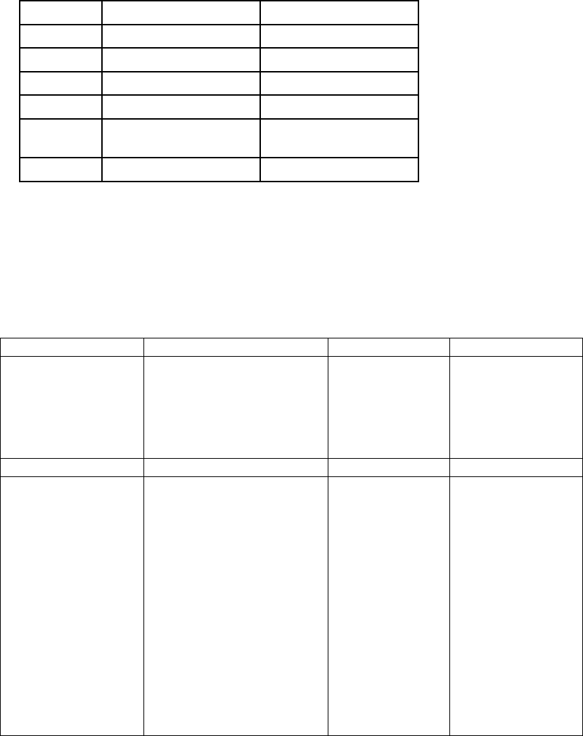
NOMENCLATURE TARIFF NUMBER SERIES
Classification, Governing NMF 100
Zip Code Basing Tariff RNLO 101
Zip Code Directory NMF 103
Zip Code Mileage Guide HGB 105
ITEM 110
DEFINITIONS
The terms:
1. "Business Day" means each day, Monday thru Friday, excluding Holidays.
2. "Business Hours" means time during which operations are generally conducted by the carrier at the point where the
service is performed.
3. "Carrier", "Consignor" or "Consignee" include the authorized representatives or agents of such "carrier", "consignor" or
"consignee".
4. "Consignee to unload the shipment" means that the consignee will perform the complete service of unloading the
freight from the position in which it was transported in or on the carrier's vehicle.
5. "Consignor to load the shipment" means the consignor will perform the complete service of loading the freight in or on
the carrier's vehicle and the proper stowing and/or stacking thereof to withstand the normal hazards of
transportation. When blocking or bracing is necessary to insure safe transportation, such blocking or bracing must
be furnished and installed by and at the expense of the consignor.
6. "Holiday" means: New Years Day, Independence Day, Labor Day, Thanksgiving Day, Christmas Day, or any other day
generally observed as a holiday by the carrier at the point where the service is performed. When the holiday falls
on Sunday, the following Monday will be considered as a holiday.
7. "Joint-line traffic" means the transportation of a shipment via two or more motor carriers, not including carriers
performing pickup service at a point of origin or delivery service at point of destination or at intermediate
interchange point as agent of the originating or delivering carriers.
8. “Less than Truckload (LTL)"- Shall be specifically designated as that quantity of freight weighing less than 20,000 lbs.,
loaded not to exceed 20 linear feet and rated subject to the limitations of the MC-M10M rate columns.
9. "Place" (See Note A), means a particular street or other designation of a factory, store, warehouse, place of business
or private residence at a "point".
10. "Point" means a particular city, town, village, community or other area which is treated as unit for the application of
line-haul rates.
11. "Single line traffic" means the transportation or a shipment via one carrier or via two or more motor carriers
specifically designated as being considered as one carrier, whether pickup service at point of origin or delivery
service at point of destination is performed by the carrier or for its account by another carrier as its agent.
12. "Site" means a particular platform or specific location for loading or unloading at a "place".
13. "Traffic handled direct" means the transportation of a shipment via only one motor carrier (not including carriers
specifically designated as being considered as one carrier), whether pickup service at point of origin or delivery
service at point of destination is performed by such carrier or for its account by another carrier as its agent.
14. "Truck" or "vehicle" means any vehicle or vehicles propelled or drawn by a single mechanical power unit and used on
the highways in the transportation of property.
15. "Two-line haul", "three-line haul" or "four-line haul" includes the carrier for whose account the provisions are
published. Unless otherwise specifically provided, two or more carriers specifically designated as being considered
as one carrier will be considered as only one line.
16. "Any Quantity (AQ)” - An AQ rate or rating is one which is specifically designated AQ in this tariff or in tariffs making
reference to this tariff and are those applicable to the quantity of articles weighing less than 20,000 lbs. and loaded
not to exceed 20 feet. (MC-M10M rate columns)
17. "Convert-Van" means a trailer that can be used as a flatbed by removing side panels.
18. “Less than Truckload (LTL)" - An LTL rate or rating is one which is specifically designated LTL in this tariff or in tariffs
making reference to this tariff and are those applicable to a quantity of freight weighing less than 20,000 lbs. and
loaded not to exceed 20 feet. (MC-M10M rate columns)
19. "Volume or Truckload (VOL or TL)"-A VOL or TL rate or rating is one which is specifically designated VOL or TL in
this tariff or in tariffs making reference to this tariff and are those for which a VOL or TL Minimum Weight is
specifically provided.
20. "TIR CARNET" means a document used to expedite the movement of goods in international trade and it guarantees
the custom duties, if any.
21. "Shipment" means a lot of freight received from one consignor at one point (or place within the confines of a single
plant), on one day, consigned to one consignee at one destination and covered by one Bill of Lading.
22. "Capacity Load" or "Loaded to Capacity" means the extent to which a standard truck is loaded with freight, each term
meaning that quantity of freight which, when loaded in or on a standard truck weighs not less than the TL minimum
weight applicable to a shipment of such freight; or, that quantity of freight, which in the manner loaded, so fills a
standard truck that no more of the shipment in the shipping form tendered can be loaded in or on the truck; or that
quantity of freight which because of unusual shape or dimensions or because of necessity for segregation or
separation from other freight requires the entire capacity of a standard truck.
23. “Upper Peninsula” (UP) is defined as zip codes 49710, 49715, 49719, 49724, 49725, 49726, 49728, 49736, 49745,
49748, 49752, 49757, 49760, 49762, 49768, 49774, 49775, 49780, 49781, 49783, 49784, 49788, 49793, 49801,
49805, 49806, 49807, 49808, 49812, 49814, 49815, 49816, 49817, 49818, 49819, 49820, 49821, 49822, 49825,
49827, 49829, 49831, 49833, 49834, 49835, 49836, 49837, 49838, 49839, 49840, 49841, 49845, 49847, 49848,
49849, 49852, 49853, 49854, 49855, 49861, 49862, 49863, 49864, 49865, 49866, 49868, 49870, 49871, 49872,
49873, 49874, 49876, 49877, 49878, 49879, 49880, 49881, 49883, 49884, 49885, 49886, 49887, 49891, 49892,
49893, 49894, 49895, 49896, 49901, 49902, 49903, 49905, 49908, 49910, 49911, 49912, 49913, 49915, 49916,
49917, 49918, 49919, 49920, 49921, 49922, 49925, 49927, 49929, 49930, 49931, 49934, 49935, 49938, 49942,
49945, 49946, 49947, 49948, 49950, 49952, 49953, 49955, 49958, 49959, 49960, 49961, 49962, 49963, 49964,
49965, 49967, 49968, 49969, 49970, 49971, 54102, 54103, 54104, 54119, 54120, 54121, 54125, 54151, 54156,
54177, 54202, 54209, 54210, 54211, 54212, 54234, 54246, 54433, 54434, 54437, 54439, 54447, 54456, 54459,
54470, 54490, 54493, 54498, 54511, 54512, 54513, 54514, 54515, 54517, 54519, 54521, 54524, 54525, 54526,
54527, 54529, 54530, 54531, 54532, 54534, 54536, 54537, 54538, 54539, 54540, 54542, 54543, 54545, 54546,
54547, 54548, 54550, 54552, 54554, 54555, 54556, 54557, 54558, 54559, 54560, 54561, 54562, 54563, 54564,
54565, 54566, 54568, 54731, 54766, 54771, 54801, 54806, 54813, 54814, 54816, 54817, 54818, 54819, 54820,
54821, 54827, 54828, 54830, 54832, 54834, 54835, 54836, 54837, 54838, 54839, 54840, 54841, 54842, 54843,
54844, 54845, 54846, 54847, 54848, 54849, 54850, 54854, 54855, 54856, 54857, 54859, 54861, 54862, 54864,
54865, 54867, 54868, 54870, 54871, 58472, 54873, 54874, 54875, 54876, 54880, 54888, 54890, 54891, 54893,
54895, 54896.
24. “NY Boroughs” is defined as zips 103-104 and zips 110-119.
25. “Manhattan” is defined as zips 100-102.
26. “WP (West Pennsylvania)” is defined as zips 150-166.
27. “EP (East Pennsylvania)” is defined as zips 167-196.
28. “CN (Canada) direct” is defined as AB (Alberta), BC (British Columbia), MB (Manitoba), SK (Saskatchewan), ON
(Ontario), QC (Quebec), NB (New Brunswick), NF (Newfoundland), NL (Labrador), NS (Nova Scotia), and PE
(Prince Edward Island),
29. “CN (Canada) indirect” is defined as AI (Alberta Indirect), BI (British Columbia Indirect), IC (Indirect Canada), NT
(Northwest Territories), NU (Nunavut), OI (Ontario Indirect), QI (Quebec Indirect), and YT (Yukon Territory).
NOTE A: The "place" shall include only contiguous property which shall not be deemed separate if intersected by a public
street or thorough-fare.
EFFECTIVE FEBRUARY 17, 2020
ITEM 150
APPLICATION OF CLASSIFICATION RULES AND REQUIREMENTS IN CONNECTION WITH RULES, RATES AND
EXCEPTION RATINGS SPECIFIED IN THIS TARIFF
A) Except as otherwise provided, rates and rating specified in this tariff are subject to the rules of National Motor
Freight Classification 100 Series, supplements thereto or subsequent reissues thereof.
B) Where a rule is published in this tariff covering the same service published herein, to the extent of its application,
will apply in lieu of the rules published in the NMFC.
C) On exception ratings where the form of shipment (loose, bulk, bundles, etc.) or the kind of container (bag, barrels,
boxes, crates, etc.), is specified in the description of article upon which ratings are provided in this tariff, such ratings
apply only when such articles are tendered for shipment in the shipping form or in the kind of container specified, and the
alternate container provisions of Rule 685 of NMFC will not apply.
ITEM 159
APPLICATION OF RATES
Rates and/or provisions in tariffs governed by this tariff are not applicable on commodities that are exempt from regulation
as a result of provisions contained in the Motor Carrier Act of 1980 as well as those commodities already classified as
"exempt" under previous provisions found in Title 49, CFR, Sub Title B, Part 1047 and clarifying administrative rulings.
ITEM 160
TARIFF APPLICATION
For inbound collect shipments, the debtor region applies using the inbound collect discount and minimum.
EFFECTIVE FEBRUARY 1, 2017
ITEM 161
END OF MONTH REFUNDS
This rule covers all end of month refunds including but not limited to: Loading Allowances, Unloading Allowances, end of
month discount, commissions, and volume incentive pricing.
Payments will only be made on invoices paid within 60 days. Payments will only be made on refunds that total at least
$20/month/pricing agreement. There will be no accumulation from month to month. Any account that doesn’t qualify for a
payment for 3 consecutive months will have the refund cancelled from their pricing agreement.
When a customer pricing agreement includes provisions for a monthly refund the refund calculation will NOT include:
1. Fuel surcharge
2. Accessorials
3. Expedited
4. Spot, Volume, TL or capacity load
5. Minimum charge floor
6. Interline
7. Pallet rate or Flat rate
Any discrepancies in amounts paid must be presented to Carrier in writing within 180 days of the date of the shipment.
Clear detail on how much is owed and why must be included.
EFFECTIVE FEBRUARY 17, 2020
ITEM 162
ALTERNATE APPLICATION OF RATES AND WEIGHTS
Item Removed – Please refer to item 640 in the NMFC book.
EFFECTIVE NOVEMBER 1, 2022
ITEM 169
DISPUTE RESOLUTION
(Exception to NMFC 100 Item 300160 and Item 300530)
Any dispute arising between the parties regarding the interpretation, application, or enforceability of the terms or
conditions of this Tariff or carrier’s offer to pay, decline, or make a firm compromise settlement offer regarding a cargo
claim or otherwise will be construed according to federal law governing transportation and the laws of the State of Ohio,
and the parties hereby stipulate that any action must be brought exclusively, as appropriate, in the United States District
Court for the Southern District of Ohio or a state court located in Clinton County, Ohio. Each party agrees to personal and
subject matter jurisdiction in either court.
EFFECTIVE FEBRUARY 5, 2015
ITEM 170
LIMITATION OF LIABILITY
(See Note A)
(a) Unless otherwise provided as set forth in Item 170, articles with an invoice value exceeding the limitations
shown below in Column B, relative to the corresponding Class in Column A, will be considered to be of
extraordinary value. Articles of extraordinary value accepted for transportation will be considered to be
released at the value per pound shown in Column B, subject to a maximum liability of $100,000.00 per
occurrence. The maximum value per pound will be arrived at by determining the actual Class of the articles
tendered, as published in NMFC 100 series, or at an Exception Class, if applicable, whichever is less, and
will apply to the weight of the lost or damaged articles. The maximum value allowed will be that which is
shown in Column B opposite the Class indicated in Column A, as follows:

COLUMN A
COLUMN B
COLUMN A
COLUMN B
COLUMN A
COLUMN B
CLASS
MAXIMUM
VALUE PER
POUND
CLASS
MAXIMUM
VALUE PER
POUND
CLASS
MAXIMUM
VALUE PER
POUND
50
$2.00
85
$12.00
175
$25.00
55
$2.00
92.5
$15.75
200
$25.00
60
$2.30
100
$19.75
250
$25.00
65
$3.95
110
$21.75
300
$25.00
70
$6.00
125
$24.75
400
$25.00
77.5
$7.75
150
$25.00
500
$25.00
EXCESS LIABILITY COVERAGE – ITEMS OF EXTRAORDINARY VALUE
(b) If shipper desires to tender a shipment requiring carrier liability in excess of carrier’s maximum liability as
defined in Item 170 (a) of this tariff, then shipper must indicate in writing in Note (1) of the Bill of Lading, the
agreed or declared value of the property being shipped. Carrier will assess an additional charge, in excess of
the total freight charges, 3% by which the agreed or declared value exceeds the carrier’s maximum liability as
defined in Item 170(a) of this tariff, or a specific released value provision found in the NMFC where
applicable. Excess liability coverage charges shall be paid by party specified in the bill of lading as
responsible for the payment of freight charges. Excess Liability Coverage charge is subject to a minimum of
$100.00 per shipment. Notwithstanding the agreed or declared value represented by the shipper, Excess
Liability Coverage and the Carrier’s Maximum Liability shall not exceed the full actual value of the goods lost
or damaged in transit or $100,000, whichever is lower. Not applicable on used products.
(c) When on shipments handled by R+L in connection with another carrier (either Air, Motor, Water or Rail), R+L
Carriers’ maximum liability in the event of loss or damage or mistakenly exported to an incorrect destination
will in no case exceed the maximum liability of the other carrier. For example, if the other carrier’s maximum
liability is $50.00 per shipment, the maximum carrier liability of the other carrier and R+L Carriers will be
$50.00 for the shipment. If the other carrier doesn’t have a maximum liability, R+L Carriers liability will be
limited to $.50/lb.
(d) If the shipper does not properly describe the freight on the Bill of Lading or uses a description of “FAK” or
“Freight of all Kinds” or other language that does not properly identify the commodities shipped, subsequent
claims for shortage or damage will be limited $.50 per pound.
(e) Liability for loss, damage, or destruction to any shipment or part thereof in connection with the Spot Quote,
Volume Quote, and/or Pallet Rate pricing system shall have a liability limited to the following:
(1) Actual invoice costs of the shipment.
(2) Applicable limited liability provisions of the NMFC, whichever is lower, subject to a maximum carrier
liability of $1.00 per pound per package and $10,000.00 per shipment.
(f) Shipments that require, note, or imply segregation from odor emitting merchandise, which are not subject to
FMCSA Hazardous Materials regulations, are subject to maximum carrier liability of $1.00 per pound or
actual cost of the merchandise damaged, whichever is lower.
(g) Shipments being staged in transit anywhere within our network are subjected to an “open air” environment
which may allow “debris or infestation” that is out of our control (i.e. bird droppings). If freight loss or damage
occurs, carrier’s maximum liability will be $2.00 per pound or the actual cost of the merchandise damaged,
whichever is lower.
(h) Liability for loss, damage, or destruction for freezable cargo shall be subject to the limitations as provided in
Item 810. Unless the bill of lading is clearly marked as “protect from freezing”, carrier will not be liable for
loss, damage or destruction resulting from failure to furnish required protection.
(i) Liability for loss, damage, or destruction to any shipment or part thereof of the following commodities will
be limited to a released value per pound as shown below:
Limit of Liability per
Maximum Payout per

Pound
Description
NMFC#
Occurrence
$1.00
Spot, Volume Quote,
Pallet Rate, or NMFC class
zero commodities
$10,000
$.10
Articles 'used""
reconditioned" or
'refurbished" or uncrated
including but not limited
to the following
commodities and their
components.
All
$10,000
$.10
Automobile parts
17800-20252 excluding
20020 & 86630
$50,000
$1.00
Barbecues or Fireplaces,
outdoor, reinforced
concrete
69320 & 69330-69500
$50,000
$.10
Electrical equipment
60500-63561 & 63570
excluding 63035- 63325
$50,000
$.50
Glass and Glassware group
86500-86960 & 87500-
88660
$10,000
$.10
Machinery
114000-133320
Excluding 114125-
114126 & 116030 &
118250 &118100 &
124000-124370
$50,000
$.10
Vehicles other than self-
propelled;
All E-Bikes
188500-189860
& 190270
$50,000
$.10
Lamps or lighting group
109000-109950
$50,000
$.10
Personal Effects (other
than government van
packs or crates)
100200-100260
$50,000
$ .10
Property bought over the
internet from companies
including, but not limited
to eBay, Amazon or
others, which is not new
merchandise, or any
shipments Not New
merchandise.
All
$10,000
$1.00
All coolers, Air
conditioners, air handlers
or Heat Pumps
114125-114126
$50,000
$1.00
Cooler Group & Appliances
& Boilers, Furnaces, Stove
and related articles
53000-53220 & 124125-
124355 & 124000-
124370 & 25400-27660
$50,000
$2.00
Compressors or air ends
NOI
118100
$50,000
$2.00
Computers, Fax, and Copy
machines and their
components
116030 & 118250
$50,000
$1.00
Furniture and other
related items
79000-82670 & 82750-
83640
$50,000
$5.00
Cigarettes, Cigars and
smokeless tobacco
products
47760-47840 &
183120
$50,000

$.50
Spa Covers
181990
$50,000
$2.00
Boating group
24500-25325
$50,000
$2.00
Ladders
108700-108920
$50,000
$2.00
Plumbers good
158000-159630
$50,000
$2.00
Metal tool boxes
29790
$50,000
$2.00
Televisions and electrical
related items
63035-63325
$50,000
$2.00
Wheels, NOI, Chrome
Magnesium, Aluminum or
other than steel
20020 & 197592
$50,000
$2.00
Awnings
33800
$50,000
$ .50
Safes
172260-172280,
172300, 172320,
172340, & 172350
$50,000
$ .50
All freight moved with a
broker or forwarder as a
shipper, consignee, or bill
All
$50,000
$.50
Chalk or wipe boards
23700
$50,000
$2.00
Solar Collectors or Solar
Panels
177010
$10,000
$1.00
Games or Toys
017240, 063025-
063595, 084040-084325
$10,000
$1.00
Athletic Goods
015520
$10,000
$1.00
Granite, Corian or Tile
Material
90390, 90500, 159530,
182340 & 182570
$10,000
$2.00
Grilles / Lights / Louvers
038020
$10,000
$2.00
Signs
176050
$10,000
$2.00
Filters
069100 & 069105
$10,000
$2.00
Paintings / Pictures /
Posters
056165
$10,000
$2.00
Billiard / Pool Tables
083980, 15700, 15730,
15790, 15770, 15810
$10,000
(j) Except as set forth in Item 170, carrier does not provide or furnish excess declared value or excess liability
coverage and declaring request for same on bill of lading shall have no effect to carrier.
(k) Corrected bills of lading or letters of authority to change or add valuation after delivery of the shipment shall
not be accepted by carriers to determine liability.
(l) Lawsuits instituted against carrier shall be instituted no later than two years and one day from the day when
written notice is given by carrier to claimant that it has disallowed its claim or part thereof. When suites are
instituted after this date, carrier shall have no cargo claim liability.
(m) When carrier performs a cross dock service on behalf of a customer to load containers for subsequent
movement with a water carrier, liability for any claims shall be limited to $.50 per pound or actual loss
whichever is less.
(n) Liability for loss, damage or destruction of property being returned to the original shipper, which was not
initially transported by R+L Carriers from the original shipper, will be limited to lost freight only and R+L
Carriers will not be responsible for damages.
(o) Liability for loss, damage or destruction of property being returned to the original shipper, which was initially
transported by R+L Carriers from the original shipper and delivered without exception, when R+L Carriers is
not be given an opportunity to inspect prior to return, will be limited to lost freight only and R+L Carriers will
not be responsible for damaged.
(p) Applicable Law: Carrier’s liability for loss, damage, contamination, destruction or delay to cargo transported

shall be that of a motor carrier as set forth in the Carmack Amendment, 49 U.S.C. § 14706, and the relevant
federal common law, regardless of whether the goods were transported interstate or intrastate, or involves
foreign commerce.
NOTE A – The provisions of this item will not apply on article subject to a specific released or actual value in Items
contained in NMFC 100 series, but in no case will R+L Carriers’ liability exceed that outlined in Part (a) of this item.
For explanation of abbreviations, notes and reference marks, see Item 110.
NOTE B – Carrier’s Liability for all Shipments originating within Canada: Carrier’s maximum liability is $2.00 per pound
based on the total weight of the shipment, or the value of the goods – lesser amount applies, subject to a maximum total
liability per shipment of $20,000.00.
NOTE C – The provisions of this item will apply the lowest possible Limitation of Liability when a shipment falls under two
(2) or more categories.
NOTE D – Carrier is not responsible for any consequential damages due to delay in service. If the shipment is moved as
guaranteed, the freight charges can be reduced due to missed service time.
NOTE E - Load and Protect liability is limited at $2.00 per pound with a maximum of $25,000 for items that are new.
Liability is limited at $.10 per pound for items that are used or reconditioned and refurbished. Residential Load & Protect
is $.10 per pound with a maximum of $25,000. Additional liability coverage is available and will apply as stated in R+L
Carriers Rules Tariff. Must be purchased prior to freight tendered on R + L bills of lading and pickup is made.
NOTE F - Commercial You Crate service liability is per Item 170, RL Rules Tariff with a maximum of $25,000.
Residential You Crate is $.10 per pound with a maximum of $25,000. Additional liability coverage is available and will
apply as stated in R+L Carriers Rules Tariff. Must be purchased prior to freight tendered on R + L bills of lading and
pickup is made.
NOTE G - Minimum Filing Requirements: A written or electronic communication from a claimant, filed with a proper carrier
within not more than nine (9) months from the date of delivery in the event of a damage claim, and not more than nine (9)
months from the date of the bill of lading in the event of loss, at a minimum shall be accompanied by the following
documents and/or information:
(a) A copy of the bill of lading or facts sufficient to enable the carrier to whom the notice of the claim is submitted
to identify the shipment(s) of property alleged to have been lost or damaged,
(b) Facts and documents upon which the claimant's assertion of carrier liability for the alleged damage or loss is
based.
(c) A specified or determinable amount of money for the alleged damage or loss, and the documents and/or
information establishing the basis for that amount of money.
(d) All concealed damaged must be reported in writing within five days from the date of delivery as noted within
the NMFC rules for a claim to be reviewed. Shipments being processed under our DWOS delivery service must be
reported within 24 hrs. via the link embedded within the consignee’s delivery notification text/email or sent in writing via
separate email for a claim to be reviewed.
EFFECTIVE AUGUST 1, 2024
ITEM 171
BUMPING CLAUSE (NON-APPLICATION)
CANCELLED EFFECTIVE JANUARY 1, 2020.
ITEM 300
ADVANCE CHARGES PROHIBITED
No advance charges that have accrued against a shipment prior to its receipt for transportation will be assumed or paid by
the carrier, except such as are incidental to the transportation of freight (including drayage charges), and then only on
such freight as in the judgment of the carrier or its agent is worth more than the total lawful charges at forced sale. No
part of the cost of any article will be advanced by the carrier.
ITEM 328
ARBITRARY CHARGES
(FERRY FEE)
1. On shipments originating at or destined to the following Islands, a Ferry Fee will apply per shipment, see Note 1:
27960
Ocracoke, NC
$125.00
48028
Harsens Island, MI
$73.60
11963
SAG HARBOR, NY
$95.40
11963
NORTH HAVEN, NY
$95.40
11964
SHELTER ISLAND, NY
$95.40
11965
SHELTER ISLAND
HEIGHTS, NY
$95.40
98261
Lopez island, WA
CALL FOR RATE
NOTE 1: This charge applies as follows:
a. Charge will be shown as a separate item on freight bill.
b. Charge is subject to NO discount.
c. Charge is in addition to all other applicable charges
NEWFOUNDLAND FERRY RECOVERY SURCHARGE
TO/FROM
CHARGE
WEIGHT
ALL U.S ZIP
CODES
NEWFOUNDLAND –
A0A-A9Z
Except: Not applicable at
postal prefixes A0P, A0R,
A2V
$28.10
$129.50
1 – 7499 LBS
7500 – 39999 LBS
FROM
TO
CHARGE
WEIGHT
ALL U.S. ZIP
CODES
NEWFOUNDLAND
–
A0A-A9Z
Except: Not
applicable at postal
prefixes A0P, A0R,
A2V
NEWFOUNDLAND –
AOA-A9Z
Except: Not applicable at
postal prefixes A0P, A0R,
A2V
ALL U.S.ZIP CODES
$450.10
$227.60
40000 LBS &
OVER
40000 LBS &
OVER
EFFECTIVE AUGUST 1, 2024
ITEM 329
ARBITRARY CHARGES
(SOUTH DAKOTA)
On shipments originating at or destined to South Dakota Zip Codes 57502-31, 57533-99, 57601-99, 57710-17, 57720-68,
57770-82, 57784, 57786-92, 57794-98 an additional charge of $27.50 per shipment will apply, see Note 1.
NOTE 1: This charge applies as follows:
a. Charge will be shown as a separate entry on freight bill.
b. Charge is subject to NO discount.
c. Charge is in addition to all other applicable charges.
EFFECTIVE SEPTEMBER 15, 2023
ITEM 330
ARBITRARY CHARGES
(NEW YORK CITY)
On shipments originating at or destined to New York Zip Codes 10000-10299 an additional charge of $115.00 per
shipment will apply, see Note 1.
NOTE 1: This charge applies as follows:
d. Charge will be shown as a separate entry on freight bill.
e. Charge is subject to NO discount.
f. Charge is in addition to all other applicable charges.
EFFECTIVE SEPTEMBER 15, 2023
ITEM 331
ARBITRARY CHARGES
(North Dakota)
On shipments originating at or destined to Zip Code 587 or 588 prefix an additional charge of $23.50 per shipment will
apply, see Note 1.
NOTE 1: This charge applies as follows:
a. Charge will be shown as a separate entry on freight bill.
b. Charge is subject to NO discount.
Charge is in addition to all other applicable charges
EFFECTIVE SEPTEMBER 15, 2023
ITEM 332
ARBITRARY CHARGES
(Northern Alberta, CN – Oil Sands Area)
On shipments originating at or destined to the northern Alberta, CN oil sands area, an additional charge will apply. See
table below.

EFFECTIVE JANUARY 25, 2021
ITEM 333
ARBITRARY CHARGES
(Saskatchewan High Cost Destination)
On shipments destined to the following Saskatchewan, CN areas, an additional charge will apply. See table below.
Abbey Colony
$110.00
Alliance Pipeline
$110.00
Alliance Pipeline
c/o Kerrobert compressor Station
$110.00
Almighty Voice Education
$110.00
Alyshsm
$110.00
Destination MIN LTL 500 1000 2000 5000 10000 20000 30000 40000
ALBIAN SANDS SITE (SHELL SITE) AB $82.00 $27.50 $23.50 $18.75 $16.25 $15.75 $9.37
ANZAC AB $82.00 $27.50 $23.50 $18.75 $16.25 $15.75 $9.35
ANZAC LODGE AB $82.00 $27.50 $23.50 $18.75 $16.25 $15.75 $9.35
BEAVER RIVER EXECUTIVE LODGE (BREL) AB $136.92 $24.55 $24.55 $22.54 $22.54 $10.40 $7.45 $7.45
BEAVERLODGE AB $41.83 $24.75 $17.15 $14.86 $13.43 $11.28 $8.46
BLACK SAND SITE AB $59.12 $24.89 $18.54 $15.72 $12.69 $11.19 $10.72 $9.21
CHEECHAM SITE AB $165.67 $30.93 $30.93 $24.46 $23.43 $20.50 $11.71 $11.71
CHRISTINA LAKE AB $125.00 $15.00 $15.00 $11.00 $9.00 $8.00 $5.05
CNRL HORIZON AB $82.00 $27.50 $23.50 $18.75 $16.25 $15.75 $9.35
CNRL(RICHARDSON PROJECT) AB $255.44 $108.21 $58.60 $34.76 $22.33 $16.63 $13.17 $9.05 $7.79 $6.15
CONKLIN (GOLD PROJECT) AB $232.00 $77.50 $53.50 $33.75 $23.75 $18.75 $10.85
CONKLIN (TOWN) AB $82.00 $27.50 $23.50 $18.75 $16.25 $15.75 $9.35
CONKLIN BP ENERGY SITE AB $82.00 $27.50 $23.50 $18.75 $16.25 $15.75 $9.35
CONKLIN CENOVUS SITE AB $232.00 $77.50 $53.50 $33.75 $23.75 $18.75 $10.85
CONKLIN LODGE AB $82.00 $27.50 $23.50 $18.75 $16.25 $15.75 $9.35
CONKLIN MEG ENERGY AB $232.00 $77.50 $53.50 $33.75 $23.75 $18.75 $10.85
CONKLIN PETRO BANK SITE AB $82.00 $27.50 $23.50 $18.75 $16.25 $15.75 $9.35
CONNARCHER AB $125.00 $15.00 $15.00 $11.00 $9.00 $8.00 $5.05
DEER CREEK SITE AB $82.00 $27.50 $23.50 $18.75 $16.25 $15.75 $9.35
FORT HILLS SITE AB $82.00 $27.50 $23.50 $18.75 $16.25 $15.75 $9.35
FORT MCKAY FIRST NATION AB $82.00 $27.50 $23.50 $18.75 $16.25 $15.75 $5.96
FORT MCKAY INDUSTRIAL PARK AB $82.00 $27.50 $23.50 $18.75 $16.25 $15.75 $5.96
GRIZZLY OIL SANDS AB $245.94 $101.35 $55.70 $32.51 $20.08 $14.17 $11.23 $7.89 $6.99 $5.52
HAMMERSTONE SITE AB $136.92 $24.55 $24.55 $22.54 $22.54 $10.40 $7.45 $7.45
HANGINGSTONE SITE AB $165.67 $30.93 $30.93 $24.46 $23.43 $20.50 $11.71 $11.71
HORIZON OIL SANDS SITE AB $82.00 $27.50 $23.50 $18.75 $16.25 $15.75 $9.35
HUSKY SUNRISE OIL SANDS SITE AB $325.77 $39.99 $39.99 $35.06 $31.23 $23.79 $14.93 $14.93
JACK PINE (SHELL SITE) AB $165.67 $50.50 $30.93 $24.46 $23.43 $20.50 $11.71 $11.71
JAPAN OIL SANDS SITE AB $125.00 $15.00 $15.00 $11.00 $9.00 $8.00 $5.05
JOSYLEN CREEK SITE AB $165.67 $50.50 $30.93 $24.46 $23.43 $20.50 $11.71 $11.71
KEARL LAKE AB $82.00 $27.50 $23.50 $18.75 $16.25 $15.75 $9.37
LAKESIDE LODGE AB $59.40 $25.66 $19.14 $16.24 $13.13 $11.56 $11.03 $9.56
LONG LAKE OPTI NEXEN SITE AB $82.00 $27.50 $23.50 $18.75 $16.25 $15.75 $7.61
MARIANA LODGE AB $82.00 $27.50 $23.50 $18.75 $16.25 $15.75 $9.35
MILDRED LAKE AB $43.45 $22.15 $13.80 $12.78 $11.94 $7.14 $4.33
MILDRED LAKE SITE AB $43.45 $22.15 $13.80 $12.78 $11.94 $7.14 $4.33
NORTHLAND FOREST SITE AB $36.07 $20.30 $11.52 $10.50 $9.05 $7.94 $5.31 $4.06
PETRO CANADA(MCKAY RIVER) AB $45.00 $14.00 $14.00 $11.00 $9.00 $8.00 $5.05
PTI BEAVER LODGE SITE AB $136.92 $24.55 $24.55 $22.54 $22.54 $10.40 $7.45 $7.45
RUTH LAKE SITE AB $82.00 $27.50 $23.50 $18.75 $16.25 $15.75 $9.35
SAPREA CREEK AB $36.07 $20.30 $11.52 $10.50 $9.05 $7.94 $5.31 $4.06
SUNCOR (FIRE BAG) AB $82.00 $27.50 $23.50 $18.75 $16.25 $15.75 $9.35
SUNCOR (PTI) MCCLELLAND LAKE SITE AB $82.00 $40.90 $26.06 $20.61 $19.74 $17.30 $9.35
SUNCOR (TAR ISLAND/MAIN PLANT) AB $39.92 $22.15 $13.80 $12.78 $11.94 $7.14 $4.33
SUNCOR(FORT HILLS) AB $82.00 $27.50 $23.50 $18.75 $16.25 $15.75 $9.35
SUNCOR(MILLENNIUM) AB $39.92 $22.15 $13.80 $12.78 $11.94 $7.14 $4.33
SUNCOR(VOYAGEUR) AB $39.92 $22.15 $13.80 $12.78 $11.94 $7.14 $4.33
SYNCRUDE(AURORA MINE) AB $165.67 $50.50 $30.93 $24.46 $23.43 $20.50 $11.71 $11.71
SYNCRUDE(MAIN SITE) AB $220.59 $91.60 $50.95 $30.23 $19.03 $13.71 $10.99 $7.76 $6.91 $5.45
WAPASU CREEK LODGE (MAIN) AB $325.77 $37.06 $37.06 $38.12 $28.94 $22.02 $13.15 $13.15
WAPASU LODGE (EAST) AB $325.77 $37.06 $37.06 $38.12 $28.94 $22.02 $13.15 $13.15
WAPASU LODGE (WEST) AB $325.77 $37.06 $37.06 $38.12 $28.94 $22.02 $13.15 $13.15

Atton’s Lake
$65.00
B & G Wreckers - Weyburn
$65.00
Baildon Colony
$115.00
Battleford Provincial Park
$55.00
Baxter Pharmacy
$110.00
Beardy' Reserve (Okimasis Reserve)
$110.00
Beechy Colony
$110.00
Big Beaver
$155.00
Big Dog Seeds
$110.00
Big River Indian Reserve
$135.00
Big Sky Farms - Rama
$110.00
Black Pearl Onion Lake Site
$280.00
Bromhead
$215.00
Buffalo Pound
$155.00
Calder
$115.00
Canadian Erector's
$110.00
Cando (Town)
$255.00
Cando-Mosquito
$165.00
Canwest Laserworks Ltd
$55.00
Cardross
$110.00
Carry the Kettle Reserve
$110.00
Casa Rio Estates
$85.00
Ceres Industries
$110.00
CFB Base / National Defence
$230.00
Chinook Power Station
$110.00
Claybank
$110.00
Clemenceau
$180.00
Conserva Park
$110.00
Cowesses
$110.00
Crescent Points
$110.00
Crossmount
$110.00
Curtwell
$110.00
Dakota Dunes Casino or Golf
$175.00
Danbury
$110.00
Day Star Reserve
$110.00
Daybreak Mills- Estevan
$110.00
Deer Valley
$110.00
Dinsmore Colony
$110.00
Donavon
$110.00
Douglas Prov. Park
$110.00
Duck Mountain Prov Park
$110.00
Duperow
$110.00
EB Campbell Hydro
$295.00
Edfield Motors Ltd
$60.00
Elk Farm
$110.00
EM Welding
$38.00

Enbridge Pipelines
c/o Kerrobert Compressor Station
$110.00
Enbridge-Powell 212826
$110.00
Enbridge-Powell 212832
$110.00
Encana
$135.00
Encana Senlac Thermal Plant
$110.00
Fiberglass Canada
$55.00
Fishing Lake
$110.00
Four Direction Child Service
$110.00
Gallant Transport / Gallant Enterprises
$110.00
Garden Plains Colony
$110.00
Gibson Energy
$110.00
Glen Bush
$110.00
Goodeve
$130.00
Gordon Reserve
$110.00
Grand Coulee
$110.00
Grasswood
$85.00
Gray
$160.00
Green Water Lake
$110.00
Green Water Provincal Park
$110.00
Hagen
$110.00
Hannin Creek
$110.00
Hearne
$155.00
Hillvale Colony
$110.00
Hubbard
$110.00
Innes Gas Plant
$155.00
Island Falls Hydro Stastion
$1,825.00
Island Lake Reserve
$385.00
K Hart Industries
$110.00
Kahkewistahaw Reserve
$110.00
Katepawa beach (5 ton delivery only)
$360.00
Kawacatoose Reserve
$110.00
Keeseekose Reserve
$110.00
Kerrobert Compressor Station
$110.00
Key Reserve
$140.00
Kinisten Reserve
$185.00
Krydor
$110.00
Lacadena
$135.00
Last Mountain Regional
$90.00
Last Mountain Stock Farm
$110.00
Liberty Power (Morse, Sk)
$265.00
Liberty Power (Morse, Sk)
$265.00
Little Black Bear Reserve
$110.00
Little Pine Reserve
$65.00
Little Red Reserve
$110.00
Lone Rock
$130.00

Madge Lake Prov Park
$110.00
Makwa
$230.00
Makwa Sahgaiehcan Band
$230.00
Manitou Lake Bible Camp
$110.00
Martins Lake
$145.00
Matador Colony
$110.00
Meadow Lake Provical Park
$280.00
Agrium Mine
$100.00
BHP Billiton Jansen
$165.00
Cory Mine Site
$150.00
Fort A La Corne - Rio Tinto
$250.00
K+S Potash Canada Legacy
$130.00
Mosaic Potash Colonsay
$100.00
PCL Vault
$100.00
Potash Corp Allan
$100.00
Potash Corp. Lanigan
$100.00
Western Potash Milestone
$110.00
Moosomin Reserve
$50.00
Morse Wind Farm (R.R. 3080 Hwy 19
$265.00
Mucowpetung Reserve
$110.00
Muskaday
$110.00
Muskowekan
$110.00
Natural Valley
$110.00
Newalta
$110.00
North 47 Truck & Trailer
$110.00
North Gate
$110.00
Ocean Man Reserve
$110.00
Ochapowace Reserve
$110.00
Okanese
$110.00
Okimasis Reserve (Beardy's Reserve)
$110.00
Okimaw Ochi Healing Lodge
hot shot ex Swift Current
$565.00
Olymel
$110.00
One Arrow
$110.00
Orcadia Young Offenders
$110.00
Outback Store
$110.00
Pakaw Lake
$315.00
Pasqua
$65.00
Pasqua Reserve
$110.00
Pasquia Regional Park
$110.00
Peepeekisis
$110.00
Pennant Farm Company (Pennat Colony)
$110.00
Petrofka Bridge
$110.00
Pheasant Rump Reserve
$110.00
Piapot Reserve
$110.00
PIERCELAND
$285.00

Plains Enviromental Willar Facility
$130.00
Port of Oungre
$110.00
Port of Regway
$110.00
Port of Torquay
$110.00
Poundmaker Reserve
$85.00
Powell - Enbridge 212826
$110.00
Powell - Enbridge 212832
$110.00
Prairie Berrie
$110.00
Prairie Dome Potato
$110.00
Ray Aspenal Farms
$110.00
Red Pheasant 1st Nations
$165.00
Riceton
$200.00
Riverside Estates
$80.00
RM of Reford - hwy 14 & Grid road 657
$65.00
Rosetown Colony
$130.00
Rosetown Flighting (10km out of town)
$50.00
Runnymede
$110.00
Sakimay Reserve
$110.00
Sask Landing
$175.00
Saulteaux Reserve
$55.00
Schmidt Flour
$110.00
Senlac
$200.00
Shield
$360.00
Sovereign Colony
$110.00
Springview Colony
$165.00
Springwater Colony
$155.00
Squaw Rapids
$295.00
Standing Buffalo
$110.00
Star Blanket Reserve
$110.00
Sully's
$110.00
Swanson
$110.00
Sweet Grass Reserve
$110.00
Swift Current Colony
$155.00
T K Organices
$110.00
T&S grains Connect
(Grain Connect Reford Terminal)
$110.00
T.W. Commodities
$110.00
Thode
$360.00
Thunderchild Reserve
$130.00
Tourism Parks Culture & Sport Pike Lake
$110.00
Trans Canada Pipeline - Kendal
$110.00
Trans Canada Piplines
$110.00
Transgas
$110.00
Turtle Lake
$110.00
Vestas (near McMahon)
$200.00
Wahpeton
$110.00

Waldeck
$110.00
Water Hen Lake
$285.00
White Cap Resource Plant
$110.00
White Mud Resources
$110.00
Whitecap Dakota First Nation
$175.00
Willowcreek Heeling CTR
$110.00
Witchican Lake Band
$110.00
Wroxton
$110.00
Yellow Quill First Nations
$110.00
EFFECTIVE JANUARY 25, 2021
ITEM 345
ARRIVAL NOTICE AND UNDELIVERED FREIGHT
ARRIVAL NOTICE:
1. Actual tender of delivery at consignee's place constitutes the notice of the arrival of a shipment.
2. If the shipment is not actually tendered for delivery, notice of arrival will be given to the consignee not later than the
next business day following the arrival of the shipment:
a) The notice will be given by the telephone, if convenient and practicable; otherwise by mail or telegraph. The notice,
however transmitted, will specify the point of origin, the consignor and commodity and weight of shipment.
b) If the consignee's address is unknown to the carrier, the notice will be mailed to the consignee at the post office
serving the point of destination shown on the Bill of Lading.
c) In the case of notification by mail, the notice will be deemed to have been given (that is, received by the addressee)
at 8:00 A.M. on the first business day after it was mailed.
UNDELIVERED FREIGHT: (See NOTES A and B)
1. If freight cannot be delivered because of the consignee's refusal to accept it, or because the carrier cannot locate the
consignee or if freight cannot be transported because of an error, or omission on the part of the consignor, the carrier
will make a diligent effort to notify the consignor promptly that the freight is in storage and the reason therefore.
2. Undelivered shipments will be subject to applicable storage or detention charges.
3. On undelivered shipments, disposition instructions printed on the Bill of Lading, Shipping Order, Shipping Label or
Container or disposition instructions issued prior to the tender of delivery will not be accepted as an authority to reship,
return or reconsign a shipment or to limit storage liability.
NOTE A-Not applicable on storage provisions for export at U.S. - Mexico border points of Brownsville, Del Rio, Eagle
Pass, Hildalgo and Laredo, TX.
NOTE B-When a shipment is undeliverable, including non-acceptance by the consignee, the carrier will issue a written
freight on-hand notice by certified mail, return receipt requested, to consignor and consignee. A charge of $9.50
per shipment will be assessed for this service in addition to all other lawfully applicable rates and charges.
EFFECTIVE: MARCH 31, 2014.
ITEM 359
BILL OF LADING DESCRIPTION REQUIREMENTS
If a shipment is inadvertently accepted upon which any information contained on a Bill of Lading, required for the
assessment of a freight classification is incomplete or believed to be incorrect, Carrier or Carrier’s agent may take action
necessary to determine the correct information. This may include the use of standard dimensions of 48x40x48 or
Dimensioning Machinery for the verification of overall shipment density. See note A, B and C.
Note A) If there is no NMFC item number stated on the Bill of Lading or if the NMFC item number provided is not currently
published with the NMFC; Carrier will utilize “Item 999999” in the billing and invoicing process to apply the class
corresponding the actual density as shown in Table 1.

Note B) If there is no freight class provided on the Bill of Lading and there isnt a valid NMFC item number provided;
Carrier will utilize “Item 999999” in the billing and invoicing process to apply the class corresponding the actual density as
shown in Table 1.
Note C) If the NMFC item number provided on the Bill of Lading conflicts with the classification or description provided;
Carrier will utilize “Item 999999” in the billing and invoicing processes to apply the class corresponding with the actual
density as shown in Table 1.
Table 1;
Sub 1
Less than 1
400
Sub 2
1 but less than 2
300
Sub 3
2 but less than 4
250
Sub 4
4 but less than 6
175
Sub 5
6 but less than 8
125
Sub 6
8 but less than 10
100
Sub 7
10 but less than 12
92.5
Sub 8
12 but less than 15
85
Sub 9
15 but less than 22.5
70
Sub 10
22.5 but less than 30
65
Sub 11
30 or greater
60
EFFECTIVE FEBRUARY 1, 2023
ITEM 360
BILLS OF LADING, FREIGHT BILLS AND STATEMENTS OF CHARGES
(Exception of NMFC Item 360)
1. When an Export shipment is tendered to the carrier, a notation "FOR EXPORT" must be entered on the Bill of Lading.
2. When validation of a Freight Bill is required as a prerequisite for payment of the freight charges and consignee fails to
validate the Freight Bill at time of delivery thus requiring the carrier to re-submit the Freight Bill for validation, a charge
of $24.40 will be assessed for that service. (See NOTE A)
NOTE A: Not applicable on shipments moving on U.S. Government Bills of Lading.
EFFECTIVE SEPTEMBER 15, 2023
ITEM 361
BILLS OF LADING – CORRECTED
Corrected Bills of Lading to change the freight charge collection status from PREPAID to COLLECT will not be accepted
once the shipment has been delivered. A corrected Bill of Lading to change the original transportation contract from
PREPAID to COLLECT will not be accepted if Section 7 (non-recourse clause) of the corrected Bill of Lading has been
signed by the consignor.
ITEM 362
BILLS OF LADING, FREIGHT BILLS AND STATEMENTS OF CHARGES
(Exception to Section 2 (C) of NMFC Item 360)
To insure the assessment of correct freight charges and avoid infractions of federal and state laws, shipper should
acquaint themselves with the descriptions of articles in the tariff under which they ship. Commodity word descriptions
must be used in Bill of Lading and Shipping Orders and must conform to those in the applicable tariff. Except as provided
in Section 3 of Item 640 of NMFC, each commodity subject to a different commodity description must be separately
described. Appropriate word abbreviations may be used. Appropriate abbreviated descriptions are permitted, provided the
NMFC item number and appropriate Sub number thereof are shown. The kind of packages used must be shown. Bills of
Lading and Shipping Orders must specify the number of packages or loose pieces in a shipment.
ITEM 363
SPECIAL SERVICES
(Order Notify Shipments)
Shipments consigned to order of any corporation, firm, institution or person shall be subject to an additional destination
terminal charge of $52.00. These charges will be in addition to all other lawful charges, including minimum charges.
EFFECTIVE SEPTEMBER 15, 2023
ITEM 364
CORRECTED BILLS OF LADING – DESCRIPTION, DENSITY, CLASS AND/OR WEIGHT
Corrected bills of lading changing the description, density, class and/or weight of commodities, in a shipment will not be
accepted by the carrier without submission of conclusive documentary proof that the description, density or weight is as
claimed on the corrected bill of lading. The carrier reserves the right to refuse corrections where the validity of the
correction information has not been verified to the satisfaction of the carrier. Corrected bills of lading changing the
description, density, or weight of the commodities can be submitted by the Shipper within thirty (30) days after the
shipment has been accepted by the Carrier.
A fee of $40.10 will be charged for any corrected bill of lading submitted changing the description, density, class and/or
weight.
EFFECTIVE SEPTEMBER 15, 2023
ITEM 365
BLIND SHIPMENTS
(Note A)
Upon written instructions received by the carrier prior to receipt of shipment at point of origin, accompanied by a through
Bill of Lading covering the shipment, the carrier will accept the shipment when tendered by the party in possession of the
shipment, subject to the following conditions:
1. Prior to notification to carrier for pickup of blind shipment, customer must contact carrier’s rate department to obtain a
Quote Number. This quote will include total freight charges based on information given by customer, including the
applicable charge of $92.80 for the blind shipment.
2. After receipt of the Quote Number, the customer will then give the blind shipment form and the BOL to the carrier’s
dispatcher. The Quote Number must be written on the Blind Shipment Form.
3. Blind shipments must move prepaid, unless the party paying for the blind shipment charge is also paying the freight
charges collect.
4. Carrier will have no responsibility or liability for incorrect billing or delivery of the blind shipment if customer fails to
obtain a Quote Number prior to the freight being received by the carrier.
NOTE A: Definition of Blind Shipment: When the billing party requests the carrier to ship the freight to a
different consignee AND/OR requests that the carrier change shipper’s name, street address, or both on the Bill
of Lading, at the time of pickup. A charge of $92.80 applies for this service. A blind shipment can require
changing the shipper or consignee information, or both. All shipments must show originating city and state of
pickup point and must be completed by the party responsible for payment of freight charges. This cannot be
changed under any circumstances.
EFFECTIVE JUNE 3, 2024
ITEM 390
CAPACITY LOADS
Except as otherwise provided on straight or mixed shipments of one article or more subject to LTL rates, each and every
trailer loaded to capacity (See Note A) will be subject to a Minimum Charge based on:
(A) Shipments moving on AQ or LTL rates, each trailer loaded to capacity (See Note A) will be subject to the (10M) Class
100 rate for 12,000 pounds, subject to a 25% discount (22% on Intrastate FL shipments). (See Note C.)
The provisions of this item are Minimum Charges and in no case may be used to reduce rates, Minimum Weight or total
charges.
NOTE A: The term "LOADED TO CAPACITY" or "CAPACITY LOAD" refers to the extent to which a trailer is loaded:
(1) The quantity of freight, which because of its unusual shape or dimensions or because of necessity for segregation
from other freight requires the capacity of a trailer; or
(2) The quantity of freight, which because of vehicle weight restrictions of State or regulatory bodies; no additional freight
can be loaded on the trailer; or
(3) That quantity of freight, which in the manner tendered to carrier or prescribed to be loaded, so fills a trailer that no
additional article in that shipping form tendered, whether or not such piece is actually tendered, identical in size to the
largest article in the shipment, can be loaded in the trailer or in any 27 feet 3 inch portion of any trailer (See Note D); or
(4) That quantity of freight, which in the manner loaded, occupies more than 20’ of the linear capacity of the trailer in
which the shipment is loaded.
NOTE B: When a Truckload exceeds the quantity that can be loaded in or on a single trailer because of its size, length,
bulk or weight, the excess (overflow) will be charged for at the applicable LTL rate.
NOTE C: Shipments originating at points in the states of IL, IN, KY, MI, OH, PA, WV or WI and are destined to points in
the states of AL, AR, FL, GA, KS, LA, MO, MS, NC, NM, OK, SC, TN, TX, or VA, shall be subject to a minimum charge
based on $7.60 per mile from origin to destination as ascertained from Zip Code Mileage Guide HGB 105.
NOTE D: Loadable length in a 28’ or Pup type trailer shall be 27 feet 3 inches. Loadable width in any trailer shall be 99
inches. Loadable height in any trailer shall be 101 inches for a single piece. Stackable freight in more than one piece can
be stacked to 109 inches.
NOTE E: Also reference item 642 for combining of shipments.
NOTE F: For purposes of calculating Linear Space occupied, any single handling unit with a length or width dimension of
over 93” shall be considered loaded with its greatest dimension along the length of a trailer.
EFFECTIVE SEPTEMBER 15, 2023
ITEM 430
COLLECT ON DELIVERY (COD) SHIPMENTS
(See NOTES A, B, C, D, E & F)
Unless otherwise provided in carriers' tariffs, collect on delivery (COD) shipments will be accepted subject to the
following provisions and charges:
SECTION 1: Shipments must be tendered on "Uniform Straight", "Straight Bill of Lading-Short Form" or "Straight" bill of
lading forms as provided for in the Rules of the NMFC.
The letters "COD" must be stamped, typed or written on all such bills of lading and shipping orders immediately before
name of consignee; OR "COD" in red letters at least one (1) inch in height with thickness of stroke 1/4-inch-thick or
greater must be stamped or printed across the face of all bills of lading and shipping orders. Only one COD shipment
may be shown and may not be subject to change dependent upon time or conditions of payment. The name and street
and post office address of consignor and consignee must be shown on the bill of lading and shipping order. On straight
Bills of Lading-Short Form there must be shown in the space provided for this purpose or in the lower left-hand corner of
space provided for "description of articles, special marks and exceptions", the following information.
Collect on Delivery $ _____________________________________ and remit to:
____________________________________________________________Street
_____________________________________________________________ City
________________________________ State _________________________Zip
COD Fee to be paid:
Prepaid ( ) Collect ( )
SECTION 2: Each package must be plainly marked, labeled, or tagged by consignor showing letters COD, and the name
and address of consignor and consignee in accordance with Item 580 of the classification.
SECTION 3: COD packages will not be accepted on the same bill of lading with packages other than COD and only
packages covered by one COD bill may be tendered on one bill of lading.
SECTION 4: If consignor desires to forward invoice or collection papers, they must be securely attached to the shipping
order copy of the bill of lading and shipping order must show the following information: "ATTACHED INVOICE (OR
INVOICES) TO ACCOMPANY SHIPMENT TO DESTINATION".
SECTION 5: COD shipments will not be accepted for transportation when consigned to one firm or person, with
instructions to collect COD charges from another firm or person.
SECTION 6: COD shipments will not be accepted for transportation subject to inspection or trial by consignee, or when
bearing instructions to make partial delivery. Carriers are only responsible to deliver the shipment in accordance with
the bill of lading contract. If, for any reason, upon presentation for delivery, COD payment is refused by the consignee,
carriers are responsible for the disposition of the shipment only in accordance with the bill of lading contract and tariff
provisions as applicable. Carriers are not responsible, in such circumstances, to seek or remit the COD amount to the
consignor or owners of goods.
SECTION 7: Intoxicating beverages will only be accepted for COD shipment subject to applicable provisions of the laws
of the state in which the point of destination is located. (See Section 389 of Title 18 of the United States Code
Annotated.)
SECTION 8: The Cod amount for COD shipments must be collected at the time such shipments are delivered to the
consignee.
SECTION 9: Only the following forms of payment will be accepted in payment of COD amounts:
(1) Cash, up to a maximum of $250.00; (NOTE F) (2) “Certified Check” which shall include (a) bank cashier's check,
(b) bank certified check, (c) bank official check or (d) money order; (3) “Company Check” which shall include a
company or personal check of the consignee. The carrier will accept payment of COD amounts only as the
agent of the consignor. Carrier’s responsibility is limited to exercising due care and diligence in collecting and
forwarding the COD payment to the consignor (Note B).
SECTION 10: The charge for collecting and remitting the COD amount for COD shipments (“COD Charge”) will be
collected from the consignee, except that such charge may be prepaid by the consignor, providing notation to that effect
is made by the consignor on the bill of lading and shipping order. The COD Charge shall be paid directly to the carrier
by separate check and must not be included in the Certified Check or Company Check made payable to the consignor.
SECTION 11:
a) Upon collection of a COD amount, carrier shall remit amount directly to the consignor or other person designated
on the bill of lading within ten (10) days after delivery of the COD shipment to the consignee.
b) The carrier shall maintain a record of all COD shipments received for delivery in such manner and form as will
plainly and readily show the following information with respect to each shipment:
(1) Number and date of freight bill
(2) Name and address of shipper or other person designated as payee
(3) Name and address of consignee
(4) Date shipment delivered
(5) Amount of COD
(6) Date collected by carrier
(7) Date remitted to payee
(8) Check number or other identification of remittance to payee
SECTION 12: The COD charge will be six percent (6%) of the COD amount, subject to a minimum charge of $197.70.
SECTION 13: Carrier will not accept shipments of explosives, designated as "Class A and dangerous explosives" or
"Class B less dangerous explosives" referred to in the Hazardous Materials Tariff (HMT), for COD shipment.
SECTION 14:
1. Each of the following requests or instructions must be made in writing:
(a) To change the status of an ordinary shipment to a COD shipment;
(b) To return the COD shipment to the consignor;
(c) To change any of the terms of the COD shipment specified in the bill of lading;
(d) To change the requested form of payment of the COD Amount from Certified Check to Company Check.
If any such written request or instruction is made, a charge of $67.70 per shipment will be assessed in addition to all other
lawful charges. Further, all charges accrued under this item must be prepaid or guaranteed to the satisfaction of the
carrier.
2. Carriers are not obligated to comply with such written request or instruction, but a reasonable effort will be made
to do so, subject to the provisions herein.
3. If a written request to change the requested form of consignee’s payment of the COD amount from Certified
Check to Company Check is received after the shipment has been tendered for delivery and refused by consignee, the
shipment will also be assessed the applicable redelivery charge as provided in carrier’s tariffs, in addition to the charge for
changing the form of acceptable payment. Consignor must guarantee payment of the charge for changing the form of
payment and the redelivery charge, if any.
NOTE A: Should shipper fail to properly prepare Bill of Lading, mark, label and tag each package, all liability on the part
of the carrier ceases should a shipment inadvertently be delivered without collecting the COD amount or
collecting incorrect form of the COD amount.
NOTE B: Due Care and Diligence shall be defined as accepting the COD payment in Cash, Certified Check or Company
Check as defined in this tariff, in accordance with the instructions of the consignee in writing on the bill of lading,
and forwarding such COD payment to consignor regular U.S. Mail, 1
st
Class. If the consignor fails to specifically
request a type of COD payment in writing on the bill of lading, Due Care and Diligence shall be defined as
accepting payment of the COD amount in one of the forms set out in this tariff and forwarding such payment to
consignor via regular U.S. Mail, 1
st
Class. Carrier’s responsibility and liability shall terminate once the COD
payment is collected and forwarded to consignor in accordance with this tariff. Further, if consignor accepts,
negotiates or attempts to negotiate the COD payment, in whatever form of payment and however received,
carrier’s responsibility or liability shall cease. If shipper does not provide carrier with written notice of its
objection to the form of COD payment collected and remitted by carrier within 10 days of carrier’s mailing of the
COD payment to shipper, shipper will be deemed to have accepted the COD payment and carrier’s
responsibility or liability under this item shall terminate. Should the COD payment become lost in the mail, it will
be the sole responsibility of the consignor to make arrangements with his customer, the consignee, for
replacement of the lost COD payment.
NOTE C: Carrier shall have no liability or responsibility should the Certified Check or Company Check be dishonored or
not paid for any reason, including, but not limited to, insufficient funds, forgery, fraud or any other unauthorized
or criminal acts of any party other than carrier.
NOTE D: Should the shipper request in writing on the bill of lading a Certified Check as COD payment, it will be the
responsibility of the shipper and consignee to make arrangements for replacement of the Certified Check
through the issuing entity. Should the Certified Check become lost by the U.S. Post Office, the consignee will
be responsible for posting the bond required by the bank before reissuing their check.
NOTE E: Should the carrier’s check payable to the shipper become list in the mail, it will be the responsibility of the carrier
to replace its check.
NOTE F: Limit on amount of cash that will be accepted does not apply when COD shipments are picked up by consignee
or his agent at carrier’s terminal.
EFFECTIVE SEPTEMBER 15, 2023
ITEM 432
COLLECTION OF CHARGES (See Note A)
1. When the Bill of Lading and Shipping Order indicates that a party other than the consignor or consignee is responsible
for pay the freight charges, such party’s name and address must appear in the body of the Bill of Lading and Shipping
Order at time of original tender.
2. Carrier will accept such shipments only when the consignor has established credit with originating carrier and
guarantees to pay all lawfully accrued charges if the third party fails to do so within the time allowed. If consignor has
not established credit and such shipment is inadvertently accepted, the consignor will be responsible for all lawfully
accrued charges if the third party fails to do so within the time allowed (See Note B).
NOTE A: Shipments subject to the provisions of this item must be billed as "prepaid" (See Note C).
NOTE B: Such shipments will not be accepted if the consignor executed Section "7", the non-recourse provision of the Bill
of Lading.
NOTE C: Carrier will not accept a corrected Bill of Lading to add third party billing instructions if the shipment has already
been delivered or if shipper has signed Section 7, the non-recourse provision, of the Bill of Lading.
ITEM 435
COLLECTION OF CHARGES AND EXTENSION OF CREDIT
(See NOTE A)
1. COLLECTION OF CHARGES WHERE CREDIT HAS NOT BEEN EXTENDED: Charges accruing under the provisions
of this tariff are due and payable and shall be collected by the carrier at the time an outbound prepaid shipment is
tendered by the shipper to the carrier for transportation, or at the time an inbound collect shipment is delivered by the
carrier to the consignee, or, in the case of accessorial service charges such as storage, reweighing, marking or COD
charges, at the time such service is requested or when possession of the shipment, or any part thereof, is relinquished
by the carrier, except where credit has been extended by the carrier to the shipper, consignee, or other party obligated
to pay the charges, under the provisions of this item.
2. EXTENSION OF CREDIT:
A. CARRIER MAY EXTEND CREDIT TO SHIPPER: Upon taking precautions deemed by carrier to be sufficient to
assure payment of the tariff charges within the credit period herein specified, carrier may relinquish possession of
freight in advance of the payment of the tariff charges and may extend credit in the amount of such charges to
those who undertake to pay them, such persons herein being called shippers, for a period of 7 days, excluding
Saturdays, Sundays and legal holidays. When the Freight Bill covering a shipment is presented to the shipper on
or before the date of delivery, the credit period shall run from first 12 o'clock midnight following the presentation of
the Freight Bill. In regard to traffic of nonprofit shippers associations and shippers' agents, within the meaning of
Section 10562 (3) and (4) of the Interstate Commerce Act, the carriers shall require such organizations to furnish
the names of the beneficial owners of the property in the Bills of Lading or at least have the Bills of Lading
incorporate by reference a document containing the names of the beneficial owners.
B. CREDIT FOR ADDITIONAL CHARGES AFTER FREIGHT RELINQUISHED: Where a common carrier by motor
vehicle has relinquished possession of freight and collected the amount of tariff charges represented in a Freight
Bill presented by it as the total amount of such charges, and another Freight Bill for additional charges is thereafter
presented to the shipper, the carrier may extend credit in the amount of such additional charges for a period of 30
calendar days, to be computed from the first 12 o'clock midnight following the presentation of the subsequently
presented Freight Bill.
C. PERIOD OF CREDIT FOLLOWING DELIVERY OF FREIGHT: Freight Bills for all transportation charges shall be
presented to the shippers within 7 calendar days from the first 12 o'clock midnight following delivery of the freight.
D. FREIGHT BILLS MAY BE PRESENTED BY MAIL: Shippers may elect to have their Freight Bills presented by
means of the United States mails, and when the mail service is so used the time of the mailing by the carrier shall
be deemed to be the time of presentation of the bills. In case of dispute as to the time of mailing, the postmark
shall be accepted as showing such time.
E. PAYMENT BY CHECKS, DRAFTS, OR MONEY ORDERS: The mailing by the shipper of valid checks, drafts, or
money orders, which are satisfactory to the carrier, in payment of freight charges within the credit period allowed
such shipper, may be deemed to be the collection of the tariff charges within the credit period for the purposes of
the rules in this part. In case of dispute as to the time of mailing, the postmark shall be accepted as showing such
time.
NOTE A: The provisions of this item shall not be construed to prohibit the extension of credit in connection with rates and
charges on freight transported for the United States, for any department, bureau, or any agency thereof, or for
any State or Territory or political subdivision thereof, or for the District of Columbia.
ITEM 440
COMMERCIAL ZONES
Rates named in this tariff will also apply from or to points and places in the following commercial zone(s), unless
otherwise specifically provided in this tariff.
AKRON-BARBERTON, OHIO COMMERCIAL ZONE
All points in Summit County, Ohio; All incorporated areas of Mogadore, Ohio and Norton, Ohio; and all points in
Wadsworth Township, Medina County, Ohio.
The named points located in the described Zone, in addition to Akron and
Barberton are:
Alside, Inc., Plant-site (Northampton Twp., Summit Co.); Aultman; Bath; Boston Heights; Botzum; Clinton; Comet; Copley;
Cuyahoga Falls, Darrowville; Earthmoving Equipment, Division of General Motors Corporation Plant-site (on Ohio
Highway 91 near Darrowville); East Liberty (Summit Co.); Fairlawn; Ghent; Greensburg (Summit Co.); Hudson; Ira;
Krumroy; Lakemore; Loyal Oak; Macedonia; Manchester; Mogadore (Entire City); Montrose; Munroe Falls; Nimisila;
Northfield; Norton (Entire City); Peninsula; Reminderville; Richfield; Sagamore Hills; Sawyerwood; Silver Lake (Summit
Co.); Stow (Summit Co.); Tallmadge; Twinsburg; Wadsworth and Western Star.
BUCYRUS, OHIO COMMERCIAL ZONE RATES
Rates which are applicable from or to Bucyrus will also apply from or to points and places in the Bucyrus Commercial
Zone unless otherwise specifically provided in this tariff or in tariffs governed by this tariff. The Bucyrus Commercial Zone
embraces the following territorial limits:
Start at the junction of U.S. 30N and Holmes Center Rd.; north on Holmes Center Rd. to Quaker Rd; east on Quaker Rd.
to its junction with S.R. 4; north on S.R. 4 to its junction with Andrews Rd.; east on Andrews Road to its intersection with
Beechgrove Rd.; south on Beechgrove Rd. to its intersection with S.R. 96; northeast on S.R. 96 to the junction of Parcher
Rd.; south on Parcher Rd. to its junction with S.R. 100; north on S.R. 100 to the junction of Shearer Rd.; west on Shearer
Rd. to its junction with Winchester West Rd.; north on Winchester West Rd. to its junction with Mt. Zion Road; west on Mt
Zion Rd. to its intersection with Denzer Rd.; north on Denzer Rd. to the intersection of Sinn Rd.; north on Sinn Rd. to its
intersection with S.R. 182; east on S.R. 182 to its intersection with U.S. 30N and the point of beginning.
CANTON, OHIO COMMERCIAL ZONE
All points in Stark Co. Ohio; Brown Twp. in Carroll Co.; and that part of Smith Twp., Mahoning Co., which is on the West
of Bandy Road.
The named points located in the described Zone, in addition to Canton, are: Alliance, Aultman, Beach City, Brewster,
Cairo (Stark Co.), Canal Fulton, Crystal Springs, East Canton, East Greenville, East Sparta, Freeburg, Greentown,
Harmon, Harrisburg (Stark Co.), Hartville, Hills and Dales, Howenstein, Justus, Limaville, Louisville, Magnolia-Portion in
Stark Co. Only, Malvern, Mapleton, Marchand, Marlboro, Massillon, Maximo, McDonaldsville, Meyers Lake, Middlebranch,
Minerva, Navarre, New Baltimore, (Stark Co.), New Franklin, North Canton, North Industry, North Lawrence, Paris, Perry
Heights, Richville, Robertsville, Uniontown (Stark Co.), Waco, Waynesburg and Wilmot.
CINCINNATI, OHIO COMMERCIAL ZONE
The Cincinnati Commercial Zone embraces the following territorial limits: All of the territory within the boundaries of
Hamilton County; in Butler County, the area of Hanover, Ross, Fairfield, and Union Twps., and St. Clair Twp., excluding
Section 1 of said Twp; also in Liberty and Lemon Twps., that area within the following described boundaries; commencing
at the intersection of the Liberty-Fairfield Twp. Line and Millikin Road; thence East on Millikin Road to the intersection with
Glendale Road; thence north on Glendale Road to the intersection with S.R. 4; thence Northeast on S.R. 4 to the
intersection with Gregory Creek; thence North along the West bank of Gregory Creek to the intersection with the Great
Miami River; thence West along the South bank of the Great Miami River to the intersection with the Liberty-Fairfield Twp.
Line; In Warren County, Deerfield Twp.; In Clermont County, Batavia, Miami, Union, those points in Tate on and North of
S.R. 125 and Williamsburg Twps.
The named points located in the described Zone, in addition to Cincinnati, are: Addyston, Afton, Amberley, Amelia,
Arlington Heights, Auburn, Baldwin Piano Co. Plant-site (Hamilton Co.), Bantam, Barnesburg, Batavia, Beechwood
(Hamilton Co.), Bethel, Bevis, Blue Ash, Branch Hill, Brecon, Bridgetown, Camp Dennison, Cherry Grove, Cheviot,
Cleves, Clover, Crescentville, Crestvue, Deer Park, Dent, Dues Industrial Park, Dunlap, Elizabethtown, Elmwood Place,
Evendale, Fairfax (Hamilton Co.), Fairfield, Fernald, Finneytown, Forest Park, Forestville, Gano, Glendale (Hamilton Co.),
Golf Manor, Greenhills, Groesbeck, Hamilton, Hamlet, Harrison (Hamilton Co.), Heekin Can Co. Plantsite, The (on
Broadwell Road near Newtown, Hamilton Co.) Hennings Mills, Hooven, Indian Hill, Jones Station, Kenwood (Hamilton
Co.), Kings Island, Kings Mills, Layhigh, LeSourdesville, Lincoln Heights, (Hamilton Co.), Lockland, Loveland, Loveland
Park, McGonigle, Madeira, Mariemont, Mason, Maud, Miamitown, Miamiville, Milford, Millville, Monfort Heights,
Montgomery (Hamilton Co.), Mt. Carmel, Mt. Healthy, Mt. Holly (Clermont Co.), Mt. Repose, Mulberry (Clermont Co.),
New Baltimore, New Burlington (Hamilton Co.), New Haven (Hamilton Co.), New Miami, Newton (Hamilton Co.), New
Miami, Newton (Hamilton Co.), North Bend, North College Hill, Norwood, Olive Branch, Overpeck, Perintown, Pisgah,
Plainville, Port Union, Reading, Remington, Rensselaer Park, Rialto, Rockdale, Rossmoyne, Royal Crown Cola Co. Plant-
site (Union Twp., Butler Co.), St. Bernard, Seven Mile, Sharonville, Sharon Woods, Silverton, 16 Mile Stand, Snidercrest,
Socialville, Springdale, Stockton, Sycamore (Hamilton Co.), Terrace Park, Twenty Mile Stand, Tylersville, Venice, West
Chester, White Oak (Hamilton Co.), Williamsburg, Williamsdale, Willowville, Withamsville, Woodlawn, Woodville,
Wyoming.
CLEVELAND, OHIO COMMERCIAL ZONE
All the territory included within the boundaries of Cuyahoga Co. Also the village of Wickliffe (Lake Co.); and the territory in
Summit Co. beginning at the intersection of U.S. 21 and the Ohio Turnpike; thence East along the Ohio Turnpike to the
eastern boundary of Summit Co.,; thence North along Summit Co. line to the northern most boundary of Summit Co;
thence west along the northern-most boundary of Summit Co. to the point of intersection with the Cuyahoga Co. line, at
the northwestern point of Sagamore Hills Twp., Summit Co.; thence South along the western Summit Co. line to the
intersection of the southwestern boundary of Sagamore Hills Twp.; thence West along the Summit Co. line to U.S. 21; and
thence South along U.S. 21 to the point of beginning; and all points and places in the cities of Willoughby, Eastlake,
Mentor and Willowick, Lake Co.
The named points located in the described Zone, in addition to Cleveland, are: Bay Village, Beachwood, Bedford,
Bedford Heights, Bentleyville, Berea, Bratenahl, Brecksville, Broadview Heights, Brooklyn, Brooklyn Heights, Brook Park,
Chagrin Falls, Cleveland Heights, Cuyahoga Heights, East Cleveland, Eastlake, Euclid (Cuyahoga Co.), Fairview Park,
Garfield Heights, Gates Mills, Glenwillow, Highland Heights, Hunting Valley (Portion in Cuyahoga Co. ONLY),
Independence (Cuyahoga Co.), Lakewood, Linndale (Cuyahoga Co.), Lyndhurst, Macedonia, Maple Heights, Mayfield
(Cuyahoga Co.), Mayfield Heights, Mentor, Middleburgh Heights, Moreland Hills, Newburgh Heights, Northfield, North
Olmsted, North Randall, North Royalton, Oakwood (Cuyahoga Co.), Olmsted Falls, Orange (Cuyahoga Co.), Parkview,
Parma, Parma Heights, Pepper Pike, Reminderville, Richmond Heights, Rocky River, Sagamore Hills, Seven Hills,
Shaker Heights, Solon, South Euclid, Strongsville, Twinsburg, University Heights, Valley View, Walton Hills, Warrensville
Heights, Westlake, West View, Wickliffe (Lake Co.), Willoughby, Willowick and Woodmere.
COLUMBUS, OHIO COMMERCIAL ZONE
All points in Franklin Co., OH; points in Fairfield, Jefferson, Canaan and Darby Twps., Madison Co., OH; points in Jerome
Twp., Union Co., OH; points in Harlem, Genoa, Orange, Liberty, Concord, Trenton, Berkshire, Berlin and Delaware Twps.,
Delaware Co., OH; points in the City of Reynoldsburg, OH; points in Violet Twp., Fairfield Co., OH, Lima Twp., Licking
Co., OH; the City of Pataskala; and Harrison Twp., Pickaway Co., OH.
The named points located in the described Zone, in addition to Columbus, are: Africa, Alton, Amity (Madison Co.), Amlin,
Arnold, Ashville, Bellpoint, Berkshire, Bexley, Big Plain, Blacklick, Brice, Briggsdale, Canal Winchester (Portion in Franklin
Co. ONLY), Center Village, Central College,Cheshire (Delaware Co.), Columbia Center, Condit, Darbydale, Delaware,
Dublin, Duvalls, Edgewater Park, Flint, Gahanna, Galena, Galloway, Georgesville, Gillivan, Gould Park, Grandview
Heights, Grove City, Groveport, Harlem, Harrisburg (Portion in Franklin Co. ONLY), Hayden, Hilliard, Hyatts, Jerome,
Kileville, Kiousville, Lewis Center, Lilly Chapel, Linworth, Lockbourne, Lockville, Marble Cliff, Minerva Park, Mount Air,
New Albany (Franklin Co.), New California, New Rome, Obetz, Pataskala, Pickerington, Plain City, Powell, Rathbone,
Reese Station, Reynoldsburg, Rickenbacker Air Force Base, Riverlea, Shadeville, Shawnee Hills, (Delaware Co.), South
Bloomfield, Stratford, Summit Station, Sunbury (Delaware Co.), Taylor Station, Upper Arlington, Urbancrest, Valleyview
(Franklin Co.), Westerville, West Jefferson (Madison Co.), Whitehall, Wildwood Springs, Worthington and Wrightsville
(Franklin Co.).
DAYTON, OHIO COMMERCIAL ZONE
All the territory included within the boundaries of Montgomery Co.; all the territory included within the boundaries of Bethel
and Monroe Twps., Miami Co.; and all the territory included within the boundaries of Bath, Beavercreek and Xenia Twps.,
Greene Co.
The named points located in the described Zone, in addition to Dayton, are: Alpha, Arlington (Montgomery Co.),
Bachman, Brandt, Brookville, Brown (Miami Co.), Byron, Centerville (Montgomery Co.), Chautaqua, Clayton (Montgomery
Co.), Crown Point, Ellerton, Englewood (Montgomery Co.), Fairborn, Farmersville, Fort McKinley, Frederick
(Fidelity)(Miami Co.), Germantown (Montgomery Co.), Ginghamsburg, Goes Station, Huber Heights, Johnsville
(Montgomery Co.), Kettering, Knollwood, Liberty, Miamisburg, Moraine, Murlin Heights, National Military Home, Site of
(Montgomery Co.), New Chicago, New Lebanon, Northridge (Montgomery Co.), Oakwood (Montgomery Co.), Oldtown
(Green Co.), Phillsburg, Phoneton, Pyrmont, Riverside (Montgomery Co.), Shiloh (Montgomery Co.), Stillwater Jct.,
Sulphurgrove, Sunbury (Montgomery Co.), Taylorsburg, Tipp City, Tippecanoe City, Trebeins, Trotwood, Union
(Montgomery Co.), Vandalia, Verona (Portion in Montgomery Co. ONLY), West Carrollton, West Charleston, Whitfield,
Wilberforce, Wright-Patterson Air Force Base, Wright View, Xenia, Zimmerman.
LIMA, OHIO COMMERCIAL ZONE
All of the territory included within the boundaries of American, Bath, Perry and Shawnee Twps., Allen Co.
The named points located in the described Zone, in addition to Lima are Allentown, Elida, Ft. Shawnee, Hume, Kemp and
Rousculp.
MANSFIELD, OHIO COMMERCIAL ZONE
All of the territory included within the boundaries of Troy, Washington, Sandusky, Springfield, Madison, Mifflin, Franklin,
and Weller Twps., and that portion of Jackson Twp. on and South of Amoy West Road and on and East of Plymouth-
Springmill Road, Richland, Co., Ohio, including all points in any municipality, any portion of which is located within the
Twps. named.
The named points located in the described Zone, in addition to Mansfield are Alta, Amoy, Crestline (Richland Co.),
Crimson, Epworth, Fleming Falls, Kings Corners, Lexington, Millsboro, Olivesburg, Ontario, Pavonia, Springmill, Toledo
Junction, Washington and Windsor.
NILES, WARREN AND YOUNGSTOWN, OHIO COMMERCIAL ZONE
All the area in Springfield, Poland, Boardman, Canfield, Ellsworth, Berlin, Milton, Jackson, Austintown, Youngstown and
Coitsville Townships, Mahoning County, except that portion of Ellsworth and Canfield Townships bounded by Duck Creek
Road on the West, Leffingwell Road on the North and Youngstown Salem Road on the East and all of the area in
Hubbard, Liberty, Weathersfield, Lordstown, Newton, Braceville, Warren, Howland, Vienna, Brookfield,
Bazetta and Champion Townships, Trumbull County.
The named points located in the described Zone, in addition to Niles, Warren and Youngstown, are:
Austintown,; Baileys Corners; Berlin Center; Boardman; Braceville; Brookfield; Campbell; Canfield; Champion (Trumbull
Co.); Champion Heights; Churchill; Coalburg, Cornersburg; Cortland, Craig Beach, Ellsworth; General Motors Corp. Plant-
site (Lordstown Twp., Trumbull Co.) near Warren; Girard; Halls Corners; Howland Corners; Hubbard; Leavittsburg;
Lordstown; Lordstown Military Reservation; Lowellville; McDonald; McKinley Heights; Masury; Mineral Ridge; New
Middletown; New Springfield; Newton Falls; North Jackson; Petersburg (Mahoning Co.); Petroleum, Phalanx, Poland,
Pricetown (Mahoning & Tumbull Cos.), Rosemont (Mahoning Co.); Struthers; Tyrell; Vienna (Trumbull Co.); West
Austintown; Woodsworth; Yankee Lake.
NORWALK, OHIO COMMERCIAL ZONE
The territory included within the boundaries of Lyme, Ridgefield, Norwalk, Sherman, Peru, Norwich, Greenfield,
Richmond, New Haven, Bronson and Fairfield Townships, Huron County, Ohio, and all territory outside Huron County
within the boundaries of the municipalities of Bellevue, Milan, New Pittsburgh, North Monroeville, and Plymouth, Ohio.
The named points located in the described zone, in addition to Norwalk, are: Bellevue, Bismark, Celeryville, Centerton,
East Norwalk, Havana, Hunts Corners, Milan, Monroeville, New Haven, New Pittsburgh, North Fairfield, North
Monroeville, Olean, Peru, Plymouth, Pontiac, Standardsburg, Steuben, Strongs Ridge, Weavers Corners, West Hartland
and Willard.
TOLEDO, OHIO COMMERCIAL ZONE
The City of Toledo and the municipality of Oregon and all of Sylvania Twp., Springfield Twp., Monclova Twp., and
Waterville Twp. in Lucas Co., and that part of Swanton Twp., Lucas Co., beginning at the intersection of US 20 (Airport
Highway) with the Swanton-Monclova Twp. line; thence along US 20 (Airport Highway) in a southwesterly direction to its
intersection with Wilkins Road; thence South along Wilkins Road to its intersection with Sager Road; thence East along
Sager Road to its intersection with the Swanton-Monclova Twp. line. And that part of Wood Co. included within the
Boundaries of Lake, Middleton, Perrysburg and Troy Twps., Wood Co. and including all points in any municipality any part
of which falls within the boundaries of the aforementioned twps.
The named points located in the described Zone, in addition to Toledo are: Bailey, Chrysler Plant-site (near Rossford),
Crissey, Dowling, Dunbridge, Harbor View, Haskins, Holland, Lemoyne, Lime City, Luckey, Maumee, Millbury, Moline,
Monclova, Northwood, Oregon, Ottawa Hills, Perrysburg, Richfield Center, Rossford (Wood Co.), Silica, Stoney Ridge,
Sugar Ridge, Sylvania, The Toledo Express Airport, Toledo Municipal Airport, Toledo National Airport, Trilby, Walbridge,
Waterville, Wernert, Whitehouse and Willis Day Industrial Park.
ITEM 450
COMMINGLING - INTRASTATE AND INTERSTATE TRAFFIC
Interstate freight covered by this tariff, or supplements referenced hereto may be shipped with intrastate freight as a single
shipment, subject to the following conditions:
A) Intrastate and interstate freight must be separately packaged.
B) Shipper must clearly designate on Bill of Lading commodities as "intrastate" or "interstate" and show separate
weights.
C) Intrastate rates will be applied to intrastate commodities and interstate rates will be applied to interstate
commodities.
D) The total weight of the shipment will determine the rate to apply. Any deficit in weight will be charged for at the
rate applicable to the article which constitutes the greatest portion of the actual weight of the shipment because two or
more articles are to equal weight, the deficit and minimum weight will be charged for at the rate applicable to the lowest
rated of such articles.
E) Carrier must have the operating authority, both intrastate and interstate, to perform the transportation the same as
if the portions were separate shipments.
ITEM 465
CONTAINERS - SHIPMENTS TRANSPORTED IN OR ON SHIPPING CARRIERS OR CONTAINERS
(Except marine type or intermodal containers designed for highway use on wheels)
Except as otherwise specifically provided, when shipments are tendered to carrier and transported in or on shipping
carriers, containers, pallets, platforms, racks, reels or skids constitute an integral part of the shipment and are to be
delivered to and receipted for by the consignee(s) named on the Bill of Lading covering the loaded movement.
Any request or provisions noted on the Bill of Lading or Shipping Order at the time of movement requesting the return of
these shipping devices, forms or packages, shall be deemed to be for informational purposes only, and it will not be
binding upon the carrier to accomplish or comply with such request or provision to complete the contract of carriage on
the shipment.
ITEM 470
CONTROL AND EXCLUSIVE USE OF VEHICLES
(Exception of NMFC ITEM 595)

The terms "vehicle" or "freight carrying vehicle", as used in this item mean a truck or trailer, but not a truck and trailer
combination. The definition of "truck" given in NMFC will NOT apply.
Sec. 1: Control of Vehicle
Except as provided in Sec. 2 of this item, no shipment is entitled to the exclusive use of the vehicle in which it is to
be transported. The carrier has control of the vehicle in which it is to be transported. The carrier has control of the
vehicle and the unrestricted right to:
a) Select the vehicle or vehicles for the transportation of the shipment.
b) Transfer the shipment to other vehicles; and
c) To load other freight in same vehicle with any such shipment.
Sec. 2: Exclusive Use of Vehicle
Upon demand (by consignor or consignee), the exclusive use of a freight carrying vehicle will be assigned to the
transportation of a shipment subject to the following conditions:
a) ONLY one freight carrying vehicle per shipment will be furnished. If freight is tendered in a quantity which will
exceed the loading limits of the vehicle furnished, the excess will be made into a second shipment requiring a
second Bill of Lading. In such instances, unless a demand for the exclusive use of another vehicle is made, the
second shipment will be transported under the provisions of Sec. 1 of this item.
b) The demand must be given in writing, attached and referred to or inserted on the Bill of Lading or shipping
order, in substantially the following form:
Exclusive use of the vehicle is demanded.
Seal Number (if any) _____________________________________________applied.
Charges are agreed to and will be paid or guaranteed by_______________________
______________________________________________________________
____________________________________
(Signature)
c) The vehicle will be devoted exclusively to the transportation of the shipment, without transfer of lading and
without the breaking of seals, if any have been applied, except in cases of emergency, when the shipment will
be giving the exclusive use of the vehicle to which it is transferred. Stopping in transit for partial loading or
unloading will NOT be permitted on shipments moving under the provisions of Sec. 2 of this item.
d) The consignor may not execute the non-recourse stipulation of the Bill of Lading, and Section 7 of the contract
terms and conditions of the Bill of Lading will NOT apply.
e) Charges on shipments moving under the provisions of Sec. 2 of this item shall be computed at the rate of
$10.20 per loaded mile (mileages computed as shown in Item 510), subject to a minimum charge of $1,293.80.
EFFECTIVE SEPTEMBER 15, 2023
ITEM 480
CUSTOMS OR INBOND FREIGHT
SECTION A:
1. Shipments moving under United States/Canada Customs Bond for Customs clearance will be assessed a fee for
inbond/sufferance warehouse handling.
Charges in cents per 100 pounds $6.80
Minimum Charges per shipment $209.90
Maximum Charges per shipment or per trailer if more than one trailer is required to transport the shipment
$601.10
Such charge shall be in addition to all other applicable charges. Party paying freight charges will be responsible for
INBOND CHARGES.
2. Shipments subject to Inbond Fees and sufferance warehouse handling:
a. On shipments subject to Customs clearance at a point in the United States where the specified broker will not set up
the IT paperwork on behalf of his client, the carrier will have Livingston prepare the bond. The cost of this will be
passed on to the payor of the freight charges. A charge of $116.49 will be applicable.
b. In the event that an Inbond shipment is required to be manifested or re-manifested by the sufferance warehouse
administrative staff, the charge shall be $116.49 per shipment per manifest or re-manifest.
c. In the event that US or Canada Customs elects to examine or inspect a given shipment and requires the carrier (next
day or within stipulated time frame) to present the shipment to an inland customs warehouse location for

examination, the charge will be $200.00 per shipment (Examination Fee) in addition to any other Inbond fees or
charges found in Item 480.
In addition, if US or Canada Customs elect to immediately examine a given shipment while at a border port location
the examination fee of $200.00 will apply in addition to any other Inbond fees or charges AND a detention fee of
$107.60 per hour shall be assessed for any portion of an hour after 2 hours of free time and until the driver is allowed
to proceed.
In the event that US or Canada Customs requires the carrier, while at a border port location, to immediately off load
shipments on a trailer in order to view and examine a given shipment or shipments, and the carrier must engage a
third party provider to unload the trailer, the payor of the freight charges shall be assessed the invoice value
submitted by the third party provider in addition to the $200.00 Examination Fee and Detention Fee outlined above.
d. Inbond shipments brought to an inland sufferance warehouse will be assessed a storage charge after 24 hours of
free time at the sufferance warehouse of $4.50 cwt., subject to a minimum of $122.40 and a maximum of $200.00
per shipment per day.
e. Any additional fees related to Inbond shipments that are applied by various inland sufferance warehouse operators
and assessed to the carrier not covered herein will be the responsibility of the payor of the freight charges consistent
with an itemized invoice provided by the sufferance warehouse operator to carrier.
f. Rates and charges found in this item may be subject to increase at any time should sufferance warehouse operators
in various local market areas decide to raise the respective rates and charges.
3. Line haul charges on shipments requiring Customs clearance at a point other than final destination will be
assessed on the basis of rates and charges applicable from point of origin to the point of Customs clearance, plus
the rates and charges applicable from the point of Customs clearance to the final destination. (See NOTE A)
4. Import freight moving Inbond may not be included in the same shipment on the same bill of lading
5. Shipments moving under Customs Bond will not be accorded the privileges of stopping in transit or split pickup or split
delivery.
6. Each IT shipment (Immediate Transportation Permit) issued for movement of an InBond shipment will be considered
as a separate shipment, and must be accompanied by one bill of lading and shipping order. (See NOTE B)
7. Shipments tendered in a vehicle sealed by or at the instructions of the consignor, or as required by competent
authority, will be considered as fully loaded or loaded to capacity and subject to the provisions of the applicable
Capacity Load Rule. On shipments cleared en route by Customs, the movement beyond such clearance does not
require a seal, normal rates and charges will apply to the beyond point.
8. Shipments moving under a Tir Carnet issued by the originating carrier are subject to a charge of $218.00 which will be
in addition to all other applicable charges (including the InBond or Customs clearance charges herein applicable), and
will be collected from the party responsible for the line haul charges.
9. When the carrier is required to pick up shipping documents or Customs release forms from a forwarder or broker for
validation prior to pickup of a shipment, a charge of $4.90 cwt., subject to Minimum Charge of $116.50, Maximum
Charge of $408.20 for each pickup of such documents, will be assessed in addition to all other applicable charges
(including the Inbond or Customs clearance charges herein applicable), and will be collected from the party responsible
for the line haul charges.
10. Any detention or storage charges will be assessed against the party responsible for the line haul charges. Such
charges must be prepaid or guaranteed to the carrier's satisfaction before the shipment is released. For the purpose of
applying storage rules, notification to the local Customs Office that the shipment is available for inspection will
constitute tender of the shipment for delivery.
11. When it is necessary for the carrier to purchase and apply "High Security Red In-Bond Seals" for shipments moving
under United States Customs Bond, a charge of $97.70 per seal will be assessed in addition to all other applicable
charges. Carrier will not be responsible for equipment or tools necessary for removal of the High Security Red In-Bond
Seal(s).
NOTE A--No beyond line haul charges will apply when the final destination is located within the terminal area of the points
of Customs clearance and is subject to the same rate basing point of Customs clearance.
NOTE B--Not applicable on volume or truckload shipments moving Inbond between steamship company piers or wharves
or when such shipments are delivered to a Customs Bonded Warehouse.
EFFECTIVE JANUARY 16, 2023
ITEM 481
CUSTOMS PROCESSING & ADMINISTRATION FEE (CPAF)
All shipments to/from Canada and the US governed by this tariff shall be subject to a surcharge of $43.50 to cover
customs processing and administration. This surcharge is in addition to the freight charges quoted herein.
EFFECTIVE SEPTEMBER 15, 2023
ITEM 482
PUERTO RICO PORT SCANNING SURCHARGE
The following port scanning surcharge will apply to all shipments bound for Puerto Rico:
LCL Shipments $.05 per cft. or $.21 per 100# (no minimum)
FCL Shipments $96.40 PC
EFFECTIVE MARCH 31, 2014.
ITEM 483
CANADA CONSOLIDATION FEE
A consolidation fee of $117.00 per consolidation load will be applied for Canadian destined freight:
(1) This will include freight picking up in the U.S. from multiple locations consolidated into a U.S. gateway and
delivering to a single destination in Canada under 1 pars clearance.
(2) This will also include freight picking up in the U.S. from one location consolidated into a U.S. gateway and
delivering to multiple destinations in Canada under 1 pars clearance.
This fee is in addition to the standard freight rate, clearance, and bond fee (if applicable).
EFFECTIVE SEPTEMBER 15, 2023
ITEM 484
PUERTO RICO TAX PROCESSING FEE
Shipments to Puerto Rico will be subject to a $10.00 per shipment tax processing fee.
EFFECTIVE JULY 1, 2014.
ITEM 486
CHICAGO HANDLING CHARGE
(PUERTO RICO SHIPMENTS)
The following surcharge will apply to all shipments bound for Puerto Rico from Chicago:
$.45 per cft or $2.75 per 100# Minimum $27.50
EFFECTIVE SEPTEMBER 15, 2023
ITEM 490
DENSITY - METHOD OF DETERMINING
Where rates are applicable, according to the density of articles as tendered for shipment, the word "density" means
"pounds per cubic foot". The cubage of loose articles or pieces, or packaged articles shall be determined by multiplying
the greatest straight-line dimensions (not circumference) of length, width and depth in inches, including all projections,
and dividing by 1728 cubic inches (one cubic foot). The density shall be the result of the division of the weight per article,
piece or package by the cubage ascertained. The weight per cubic foot relates to the density of each shipping package or
piece and not to the shipment as a whole.
SAMPLE:
48" X 40" X 36" = 69,120 Cu. In. - 1728 = 40 Cu. Ft.
Unit weight = 125 lbs. - 40 Cu. Ft. = 3.13 PCF
3.13 Pounds per Cubic Foot = Density
ITEM 499
DEAD HEAD CHARGE
When shipper requests a truck to dead head excessively (greater than 50 miles) to load origin, then a charge of $2.40 per
dead head mile plus applicable fuel surcharge (FSC) will apply.
EFFECTIVE SEPTEMBER 15, 2023
ITEM 500
DETENTION - VEHICLES WITH POWER UNITS (Truckload)
Detention - Vehicles with Power Units
This item applies when carrier's vehicles with power units are delayed or detained on the premises of consignor,
consignee, or on other premises designated by them, or as close thereto as conditions will permit, subject to the following
provisions:
Sec. 1. - General Provisions
a) This item applies only to vehicles which have been ordered or used to transport shipments subject to truckload rates.
For the purpose of this item, the term "truckload rates" shall be considered to include shipments moving on a rate
subject to a stated minimum weight of 20,000 pounds or more when not designated as a truckload rate, and, where
applicable, shipments which are assessed charges based on the provisions of a Capacity Load Rule or are accorded
Exclusive Use of Vehicle Service or Expedited Service.
b) This item applies only when vehicles are delayed or detained at the premises of pickup or delivery and only when such
delay or detention is not attributable to the carrier.
c) Free time for each vehicle will be as provided in Sec. 4. After the expiration of free time, charges will be assessed as
provided in Sec. 5.
d) The detention charges due the carrier will be assessed against the consignor in the case of loading and against the
consignee in the case of unloading, irrespective of whether line-haul charges are prepaid or collect. When detention
charges are attributable to others who are not parties to the Bill of Lading, the party responsible for the payment of the
freight charges will be held responsible for any accrued detention charges. (See Note A)
NOTE A: At those marine terminal facilities where Federal Maritime Commission detention charges apply, carrier charges
pursuant to this rule will be assessed on the party responsible for the payment of the freight charges to the
extent such charges exceed those of the Federal Maritime Commission.
e) When carrier's employee assists in loading, unloading, or checking the freight, this item will apply whether or not the
power unit is actually detained.
f) Nothing in this item shall require a carrier to pick up or deliver freight at hours other than carrier's normal business
hours. This shall not be construed to restrict a carrier's ability to accept pickup and delivery schedules at hours other
than its normal business hours.
Sec. 2. - Definitions
a) "Vehicle" means straight trucks or tractor-trailer combinations used for the transportation of property.
b) "Loading" includes furnishing carrier with the Bill of Lading, forwarding directions or other documents necessary for
forwarding the shipment.
c) "Unloading" includes:
(1) Surrender the Bill of Lading to the carrier on shipments billed, "To Order";
(2) Payment of lawful charges to the carrier when required prior to delivery of the shipment;
(3) Notification to the carrier that vehicle is unloaded; and
(4) Signing of the delivery receipt.
d) "Premises" means the entire property at or near the physical facilities of consignor, consignee or other designated
party.
e) "Site" means a specific location at or on the premises of consignor, consignee or other designated party.
f) "Normal non-working periods" means meal, coffee and rest breaks.
g) "Pallet" means pallets, platforms, shipping racks or skids with or without standing sides or ends, but without tops.
Sec. 3. - Computation of Time
a) Commencement and termination:
1) The time per vehicle shall begin to run upon actual notification by carrier's employee to a responsible representative
of consignor, consignee or other designated party at the premises of pickup or delivery of the arrival of the vehicle
for loading and unloading. Upon such notification, the responsible representative of consignor, consignee or other
designated party may enter the time of arrival onto the carrier's detention record. If the representative refuses to
enter the time, then carrier's employee will enter the time and it will be binding upon each party.
2) Time shall end upon completion of loading or unloading except as provided for in Paragraph (c) of this section.
Upon such completion, a responsible representative of consignor, consignee or other designated party may enter
the time of completion onto the carrier's detention record. If the representative refuses to enter the time, then
carrier's employee will enter the time and it will be binding.
b) Prearranged scheduling:
1) Upon reasonable request of consignor, consignee or others designated by them, carrier will, without additional
charge, enter into a prearranged schedule for arrival of the vehicle for loading or unloading.
2) When the carrier enters into a prearranged schedule with consignor, consignee or others designated by them for the
arrival of the vehicle for loading or unloading and carrier is unable for any reason to maintain such schedule, then
carrier and consignor, consignee or other party designated by them have the option to agree to a mutually
convenient and prompt alternative arrival time or in the event such agreement cannot be reached, to compute
detention time against consignor, consignee or other party designated by them from carrier's actual arrival time
subject to an extension of 15 minutes, or fraction thereof, the vehicle is delayed beyond the originally scheduled
arrival time; in no case shall such extended free time exceed 60 minutes.
3) If carrier's vehicle arrives prior to scheduled time, time shall begin to run from the scheduled time or actual time
loading or unloading commences, whichever is earlier.
c) Conditions governing the computation of time:
1) Computations of time are subject to and are to be made within the normal business hours at the designated place of
pickup or delivery. If carrier is permitted to work beyond this period, such working time shall also be included.
2) When loading or unloading is not completed at the end of normal business hours at the designated place,
consignor, consignee or other party designated by them shall have the option:
(I) to request that the vehicle without power remain at its premises subject to the provisions of Sec. 4 (d); or
(II) to request that the vehicle with power be returned to carrier without being subject to charges for storage or
redelivery so long as free time has not yet expired. When the vehicle is returned for completion of loading or
unloading, the computation of any remaining free time will resume. If free time has expired and detention has
begun to accrue, storage or redelivery charges as may otherwise be provided will be assessed.
3) When carrier's employee interrupts loading or unloading by the taking of any normal non-working periods, any such
time will be excluded from the computation of time in excess of free time.
Sec. 4. - Free Time
a) Free time shall be computed as follows:
ACTUAL WEIGHT FREE TIME IN HOURS PER

IN POUNDS PER VEHICLE STOP
VEHICLE STOP
(See Note B) FLOOR LOADED PALLET LOADED
10,000 but less than 20,000 3 1
20,000 but less than 28,000 4 2
28,000 but less than 36,000 5 2
36,000 but less than 44,000 6 2
44,000 or more 7 2
NOTE B: Also applies to the last vehicle used in transporting overflow truckload shipments, or to vehicles containing
truckload shipments stopped for completion of loading or partial unloading.
b) When at least 90 percent of the shipment weight (exclusive of pallet weight) is loaded on pallets, or when shipment is
loaded on flat-bed or other open-top equipment, free time shall be as provided under "PALLET LOADED" as shown
above, except that, when open-top equipment is used in lieu of closed equipment to transport shipment of unpalletized
general commodities, free time will be as provided under "FLOOR LOADED" as shown above.
c) When more than one truckload shipment or a truckload shipment and one or more less-than truckload (LTL) or any
quantity (AQ) shipments are loaded) on one vehicle at the premises of consignor or when more than one truckload
shipment or a truckload shipment and one or more LTL or AQ shipments are unloaded from one vehicle at the
premises of consignee or other designated party, the combined weight will be used to determine free time, in all other
instances the individual shipment weight will be used.
d) When a vehicle with power is changed to a vehicle without power at the request of consignor, consignee or other party
designated by them, the free time and detention charges will be applied as follows:
1) If the change is requested and made before the expiration of free time for a vehicle with power, free time will cease
immediately at the time the request is made, and detention charges for vehicles without power will immediately
commence with no further free time allowed.
2) If the change is requested and made after the expiration of free time for a vehicle with power, free time and
detention charges will be computed on the basis of a vehicle with power up to the time the change was requested.
In addition, thereto, the vehicle will immediately be charged detention for vehicles without power with no further free
time allowed.
e) When a vehicle is both unloaded and reloaded, each transaction will be treated independently of each other, except
that when loading is begun before unloading is completed, free time for loading shall not begin until free time for
unloading has elapsed.
f) Loading or unloading at more than one site at or on the premises of consignor, consignee or other designated party
shall constitute one vehicle stop.
Sec. 5 - Charges
When the delay per vehicle beyond free time is 1 hour or less, the charges will be $189.80. For each additional 30
minutes or fraction thereof, the charge will be $94.10.
Sec. 6 - Records
A written record of the following information must be maintained by the carrier on all truckload shipments, and such record
must be kept available at all times:
a) Name and address of consignor, consignee or other party at whose premises freight is loaded or unloaded;
b) Identification of vehicle tendered for loading or unloading;
c) Date and time of notification of arrival of the vehicle for loading or unloading;
d) Date and time loading or unloading is begun;
e) Date and time loading or unloading is completed;
f) Date and time vehicle is released by consignor, consignee or other party at place of pickup or delivery after loading or
unloading is completed;
g) Actual time of non-working periods;
h) Total actual weight of shipment or shipments loaded or unloaded.
i) Whether articles are tendered under a prearranged schedule for loading or unloading;
j) Date and time specified for vehicles tendered under prearranged schedule; and
k) Alternative made when a vehicle is tendered under a prearranged schedule that was not adhered to.
EFFECTIVE SEPTEMBER 15, 2023
ITEM 501
DETENTION - VEHICLES WITHOUT POWER UNITS
Detention - Vehicles without power units - spotting or dropping trailers (See Note A)
This item applies when carrier's vehicles without power units are delayed or detained on the premises of consignor,
consignee or on other premises designated by them, or as close thereto as conditions will permit, subject to the following
provisions:
NOTE A: For the purpose of this item, the terms "spotting" and "dropping" are considered to be synonymous and are used
interchangeably.
Sec. 1. - General Provisions
a) Subject to the availability of equipment, carrier will spot empty or loaded trailers for loading or unloading on the
premises of consignor, consignee or on other premises designated by them, or as close thereto as conditions will
permit.
b) Loading or unloading will be performed by consignor, consignee, or other party designated by them. When carrier's
employee assists in loading, unloading or checking the freight, the detention provisions governing vehicles with power
units will apply. In the case of spotting for loading, the Bill of Lading must show "Shipper Load and Count."
c) Carrier responsibility for safeguarding shipments loaded into trailers spotted under the provisions of this item, shall
begin when loading has been completed and possession thereof is taken by the carrier.
d) Carrier responsibility for safeguarding shipments unloaded from trailers spotted under the provisions of this item, shall
begin when loading has been completed and possession thereof is taken by the carrier.
e) Free time for each vehicle will be as provided in Sec. 3. After the expiration of free time, charges will be assessed as
provided in Sec. 4.
f) The detention charges due the carrier will be assessed against the consignor in the case of spotting for loading and
against the consignee in the case of spotting for unloading irrespective of whether charges are prepaid or collect.
g) Nothing in this item shall require a carrier to pick up or deliver spotted trailers at hours other than carrier's normal
business hours. This shall not be construed as a restriction on carrier's ability to pick up or deliver spotted trailers at
hours other than its normal business hours.
Sec. 2. - Definitions
The following general definitions will apply when the below terms are used in this item:
a) "Vehicle" means tractor-trailer combinations used for the transportation of property where:
1) "Trailer" means mobile units with or without wheels, used to transport property and,
2) "Tractor" means a mechanically powered unit used to propel or draw a trailer or trailers upon the highways.
b) "Loading" includes:
1) Furnishing of the Bill of Lading, forwarding directions, or other documents necessary for forwarding the shipment to
the carrier, and
2) Notification to the carrier that the vehicle is loaded and ready for forwarding.
c) "Unloading" includes:
1) Surrender the Bill of Lading to the carrier on shipments billed "to Order".
2) Payment of lawful charges to the carrier when required prior to delivery of the shipment.
3) Notification to the carrier that vehicle is unloaded and ready for forwarding, and
4) Signing of delivery receipt.
d) "Premises" means the entire property at or near the physical facilities of consignor, consignee or other designated
party.
e) "Site" means a specific location at or on the premises of consignor, consignee or other designated party.
f) "Spotting" means the placing of a trailer at a specific site designated by consignor, consignee or other party designated
by them, detaching the trailer and leaving the trailer in full possession of consignor, consignee or other designated
party, unattended by carrier's employee and unaccompanied by power unit.
Carrier will not move the trailer until such time as it has received notification pursuant to Sec. 3, that the trailer is ready for
pickup at any site on premises. Consignor, consignee or other designated party may shift the spotted trailer with its own
power units at its own expense and risk for the purpose of loading or unloading. Empty trailers placed at the premises of
consignor without specific request are not spotted until the carrier receives a consignor's request and places a trailer for
spotting. Movement of the trailer from the consignor's premises to the specific site for spotting shall be the obligation of
the carrier, and free time shall accrue as provided in Sec. 3.
Consignor, consignee or other designated party will indemnify, protect, save and hold harmless carrier from any claims,
liabilities, losses, damages, costs and expenses of any kind, imposed upon, incurred by or asserted against carrier arising
from, connected with or resulting from consignor, consignee or other designated party shifting or moving the spotted trailer
with its own power units.

Sec. 3. - Computation of Free Time
a) Commencement of spotting and free time:
1) Spotted trailers will be allowed 24 consecutive hours of free time for loading or unloading. For trailers spotted for
unloading, such time shall commence at the time of placement of the trailer at the site designated by the consignee,
or other party designated by consignee. For trailers spotted for loading, such time shall commence when the trailer
is spotted at the site specifically designated by the consignor or a party designated by consignor.
2) When any portion of the 24-hour free time extends into a Saturday, Sunday or Holiday (National, State, or
Municipal), the computation of time for such portion shall resume at 12:01 a.m. on the next day which is neither a
Saturday, Sunday or Holiday.
3) Free time shall not begin on a Saturday, Sunday, or Holiday (National, State or Municipal), but at 8:00 a.m. on the
next day which is neither a Saturday, Sunday or Holiday.
4) When a trailer is both unloaded or reloaded, each transaction will be treated independently of the other, except that
when unloading is completed, free time for loading shall not begin until free time for unloading has elapsed.
b) Termination of spotting and notification:
1) Consignor, consignee or other party designated by them shall notify carrier when loading or unloading has been
completed and the trailer is available for pickup. The trailer will be deemed to be spotted and detention charges will
accrue until such time as the carrier receives notification. Notification by telephone if convenient, and practical,
otherwise by telegraph or mail, shall be given by consignor, consignee or other party designated by them at their
own expense, to carrier or other party designated by carrier for the purpose of advising such carrier or other party
that the spotted trailer has been loaded or unloaded and is ready for pickup. If notification is by telephone, carrier
may require written confirmation.
2) When a spotted trailer is changed to vehicle with power at the request of consignor, consignee or other party
designated by them, the free time and detention charges will be applied as followed:
I) If the change is requested and made before the expiration of free time for a spotted trailer, free time will cease
immediately at the time request is made, and detention charges for vehicles with power will immediately
commence with no further free time allowed.
II) If the change is requested and made after the expiration of free time for a spotted trailer, free time and detention
charges will be computed on the basis of a spotted trailer up to the time the change was requested. In addition,
thereto, the vehicle with power with no further free time allowed.
c) Prearranged Scheduling:
1) Upon reasonable request of consignor, consignee or others designated by them, carrier will, without additional
charge, enter into a prearranged schedule for the arrival of trailers for spotting.
2) If carrier's vehicle arrives later than the scheduled time, time shall begin to run from actual time spotting
commences.
3) If carrier's vehicle arrives prior to scheduled time, time shall begin to run from the scheduled time or actual time
spotting commences, whichever is earlier.
Sec. 4. - Charges
a) General detention charges: After the expiration of free time as provided in Sec. 3 (a) of this item, charges for detaining
a trailer will be assessed as follows:
CHARGE
1) For each of the first and second 24-hour periods or Fraction thereof (Saturdays, Sundays or Holidays excepted)
$133.40
2) For each of the third and fourth 24-hour periods or Fraction thereof (Saturdays, Sundays or Holidays excepted)
$200.80
3) For the fifth and each succeeding 24-hour period or Fraction thereof (Saturdays, Sundays or Holidays included)
$269.00
b) Delay in trailer pickup charge: No additional charge will be made for picking up trailers spotted under this item when
such pickup can be performed within 30 minutes after arrival of driver and power unit at premises of consignor,
consignee or other party designated by them. When a delay of more than 30 minutes is encountered, detention
charges for vehicles with power will commence from the time of arrival as specified in Item 500.
c) Strike interference charge: When, because of strike of employees it is impossible for consignor, consignee or other
party designated by them to make available for movement by carrier any partially loaded or empty trailers detained on
their premises, a detention charge of $119.20 per day or fraction thereof, per trailer will be made following expiration of
free time. Saturdays, Sundays and Holidays shall be included after the 4th day of charges.
Sec. 5 - Records
A written record of the following information must be maintained by the carrier on all spotted trailers and such record must
be kept available at all times:
a) Name and address of consignor, consignee or other party at whose premises the trailer is spotted;
b) Identification of spotted trailer;
c) Date and time of arrival of the trailer for spotting;
d) Date and time notification that the spotted trailer is ready for pickup was received by carrier;
e) Date and time of arrival and departure of power unit for pickup;
f) The duration of any strike induced delay on the premises of consignor, consignee or other designated party which
resulted in carrier's inability to obtain the release of any trailer, and any actions take to hasten the release;
g) Whether trailers are spotted under a prearranged schedule; and
h) When trailers spotted under prearranged schedule, the date and time specified therefore.
EFFECTIVE SEPTEMBER 15, 2023
ITEM 502
DETENTION - LTL OR AQ SHIPMENTS
This item applies when carrier's vehicles with power units are delayed or detained either on the premises of consignor or
consignee or as close to thereto as conditions will permit, subject to the following provisions:
Sec. 1. - General Provisions
1. This item applies only to vehicles which have been ordered or used to transport shipments:
(a) Subject to LTL rates subject to a stated minimum weight of less than 20,000 pounds:
(b) Not subject to shipments which are assessed charges based on provisions of Item 390 (Capacity Loads) or
Item 470 (Exclusive Use of Vehicles).
2. When carrier's employee assists in loading, unloading or checking the freight, this item will apply whether or not the
power unit is actually detained.
3. Nothing in this item shall require a carrier to pick up or deliver freight at hours other than such carrier's normal
business hours.
4. When vehicle is both unloaded and reloaded, each transaction will be treated independently of the other, except
that when loading is begun before unloading is completed, free time for loading shall not begin until free time for
unloading has expired.
5. Freight remaining undelivered after the accrual of any detention charges may be placed in storage. Such freight shall
be subject to accrued detention charges up to the time freight is placed in storage and shall immediately become
subject to storage charges. If the freight is later tendered for delivery, the charge for redelivery will apply. In such
event, detention charges as provided in Sec. 5. of this item, will immediately become applicable.
6. When, through no fault of the carrier, the loading or unloading of a vehicle with power unit cannot be completed at the
end of a normal business day.
(a) Consignor or consignee may request that the vehicle without power remain at its premises and the provisions
of Sec. 4. (2) will apply.
(b) Consignor or consignee may request that the vehicle with power be returned to carrier's premises. At that
time, computation of any remaining free time will cease. That portion of the shipment in the carrier's possession is
subject to storage. When the vehicle is returned to consignor's or consignee's premises, computation of any
remaining free time will resume. The portion of a shipment that is redelivered is subject to redelivery charges
provided in Item 830.
Sec. 2. – Definitions
"Loading" - includes the furnishing to the carrier the Bill of Lading or forwarding directions or documents necessary for
forwarding of the shipment.
"Unloading" - includes:
a) Surrender to the carrier of Bill of Lading on shipments billed "To Order".
b) Payment of lawful charges to the carrier when required prior to delivery of the shipment.
c) Notification to the carrier that the vehicle is unloaded.
d) Signing delivery receipt when delivering carrier's agent is present at unloading.
Sec. 3. - Computation of Time
1. Except as provided in Paragraphs (2) and (3), computation of time shall begin upon notification by the driver to the
responsible representative of the consignor or consignee of the arrival of the vehicle for loading or unloading. time shall
end upon completion of loading or unloading and receipt by the driver of a signed Bill of Lading or receipt for delivery.
2. Computations of time are subject to and are to be made within the normal business day at the designated premises at
place of pickup or delivery, except:
(a) When loading or unloading is not completed at the end of such day, time will be resumed upon notification by
driver to the responsible representative of the consignor or consignee that he is ready to resume loading or
unloading.
(b) When loading or unloading is interrupted for a normal meal period, meal time not to exceed one hour, will be
excluded from computation of time.
3. When carrier is permitted to work before or after the normal day, such working time shall also be included.
4. When a Debtor consignor or Debtor bill to tenders or Debtor consignee receives more than one LTL shipment at one
time, the combined weight of that Debtor will be used to determine free time. The free time will be increased by 5 minutes
for each shipment subject to maximum of 60 minutes additional free time
Charges of that Debtor will be pro-rated on the basis of the weight of each individual shipment for that Debtor. Where
single or multiple LTL shipments subject to LTL rates exceed the carrying capacity of one vehicle, free time for each
vehicle shall be computed separately.
Sec. 4. - Free Time
1) Free Time shall be as follows:
ACTUAL WEIGHT FREE TIME IN HOURS
IN POUNDS PER VEHICLE STOP
PER
VEHICLE STOP PALLET LOADED
1 – 20,000 .5
1. Once a vehicle with power is placed for loading or unloading and then changed to a vehicle without power at the
request of consignor or consignee, the free time and detention charges will be applied as follows:
(a) If the change is requested and made within free time allowed for a vehicle with power, free time will cease
immediately at the time request is made and detention charges for vehicle without power will be applied
immediately with no further free time allowed.
(b) If the charge is requested and made after expiration of free time for a vehicle with power, free time and
detention charges will be computed on the basis of a vehicle with power up to the time the change was requested.
In addition thereto, vehicle will immediately be place on detention for vehicle without power with no further free
time allowed.
Sec. 5 – Charges
When the loading or unloading is delayed, the charge per vehicle for each 15 minutes, or fraction thereof, beyond free
time will be $66.40 subject to a minimum charge of $161.70.
EFFECTIVE MAY 1, 2024
ITEM 504
DETENTION - USE OF VEHICLE AT DESTINATION FOR THE PURPOSE OF
HOLDING PUBLIC SALE OF THE CONTENTS THEREOF
Except as otherwise provided, where the consignor and/or consignee has made proper arrangements with the delivering
carrier for the use of a vehicle at the consignee's place of business for the purpose of holding a public sale of the
merchandise contained in said vehicle, the following rules shall govern:
1. Arrangements for the service authorized in this item must be made with the delivering carrier before shipment is
tendered for transportation. The instructions and/or Bill of Lading and/or Shipping Order shall clearly state the place
and site at which the vehicle will be used for the purpose of conducting the sale of the merchandise which will be
transported in the vehicle.
2. These provisions will only apply on shipments which have moved to the point of destination on VOL or TL rates and on
which Stopping-in-Transit Privileges for Partial Unloading have not been accorded.
3. These provisions will only apply when the vehicle has been loaded and sealed by the consignor and will be unload by
the consignee. Bill of Lading and Shipping Order must specify that loading was performed by consignor and that
unloading is to be done by consignee. The provisions of this rule will apply only on shipments on which Bill of Lading
and Shipping Order have been noted "Consignor load, count and seal."
4. FREE TIME:
(a) Except as otherwise provided herein, 8 hours free time will be allowed for the unloading of the vehicles after placed
at the site designated by the consignee.
(b) When the vehicles are placed prior to 8:00 a.m. of any day, Monday to Saturday, inclusive, free time shall begin at
8:00 a.m. of such day.
(c) When vehicles are placed after 5:00 p.m. of any day, Monday to Saturday, inclusive, free time shall begin at 8:00
a.m. of the following day, except as provided in Paragraph 4(e).
(d) When any portion of the free time provided in Paragraph 4(a) extends beyond 5:00 p.m. of any day, Monday to
Saturday, inclusive, such portion of free time shall be computed from 8:00 a.m. of the next day which is neither a
Federal, State or Municipal Holiday, nor a Sunday.
(e) Free time shall not begin on a Sunday or a Federal, State or Municipal Holiday observed at point of placement, but
at 8:00 a.m. of the next day which is neither a Federal, State or Municipal Holiday nor a Sunday,
5. CHARGES:
After the expiration of free time prescribed herein, use charges will be assessed as follows:
(a) For the first 24 hours or fraction thereof, $134.80 per vehicle (Sundays and Holidays excepted).
(b) For the second 24 hours or fraction thereof, $200.80 per vehicle (Sundays and Holidays excepted).
(c) For the third and each succeeding 24 hours or fraction thereof, $251.00 per vehicle (including Sundays and
Holidays).
(d) All charges accruing under the provisions of this item shall be paid by the consignee.
EFFECTIVE SEPTEMBER 15, 2023
ITEM 505
DETOUR CHARGE
(ALBERTA, CN)
For freight to and from British Columbia, passing through Alberta, CN, a detour accessorial charge of $.80 per cwt, $11.90
minimum, and $223.00 maximum will apply.
EFFECTIVE NOVEMBER 1, 2021
ITEM 507
DISCOUNTS - NON-APPLICATION OF
Cancelled effective May 1, 2010.
ITEM 508
DISCOUNTS - NON-APPLICATION OF
Payment of discount freight bills (invoices) must be made within 45 days from date of freight bill (invoice). Failure to
comply with this provision will void the discount and FAK provisions applied and the billing will be modified based upon
applicable class rates (NMFC) published in tariffs issued by R & L Carriers Agency.
ITEM 510
DISTANCES (Rate Basis Numbers)
A) Except as otherwise shown in tariffs making reference hereto, the distances shall be computed from the point of
loading to the point of unloading by the shortest highway route and shall be ascertained by compilation of distances as
shown in =(a) Zip Code Mileage Guide, HGB 105 (series), issued by Household Goods Carrier's Bureau, Inc., Agent,
and by supplements thereto and successive reissues thereof, or +(b) Section 2, RNLO 500, issued by R & L

TRANSFER, INC.
B) Where the shipper, consignee or owner requests transportation of a shipment over a route longer than the shortest
route, the mileage over the longer route shall be used to determine the charge.
C) In determination of mileage, fractions of a mile shall be increased to the next whole figure.
ITEM 520
EQUIPMENT – SPECIAL (Lift Gate)
When a carrier upon request of the consignor or consignee provides a vehicle with devices attached for loading or
unloading, a charge of $14.20 per 100 pounds, subject to a Minimum Charge of $203.90 and a Maximum Charge of
$670.90 per shipment will apply. Such charge will be in addition to all other applicable charges. (See Note 1)
NOTE 1: Tailgate Pickups/Deliveries - Maximum weight 2000 lbs. If a customer has a skid that weighs more than 2000
lbs., the skid will be broken down for pickup or delivery and the lift gate charge doubled.
NOTE 2: For skids longer than 60” L, the lift gate charge will be doubled.
Maximum size for the skid to fit on tailgate is:
60” L
48” W
EFFECTIVE SEPTEMBER 15, 2023
ITEM 545
EXPORT, IMPORT, COASTWISE AND INTERCOASTAL SHIPMENTS--IN TRAILERS
AND/OR CONTAINERS RECEIVED FROM OR DELIVERED TO WATER CARRIERS
Upon request, export, import, coastwise and intercoastal shipments will be transported in trailers and/or containers not
owned by the motor common carriers’ parties to this tariff. When shipments so handled are received from or delivered to
water carriers, rates provided in tariffs governed hereby will apply on the weight of the shipments not including the weight
of the trailers; and the shipments will be transported under the conditions and subject to the additional charges provided in
this section.
APPLICATION OF GENERAL PROVISIONS
Section 1:
1) Loading shall, in no case, exceed the maximum weight that may be lawfully transported.
2) Vehicle sizes refer to outside length of vehicle.
3) Where time records are required motor, common carrier must maintain such records and must make them available for
inspection by authorized representative of regulatory authorities.
4) When containers are to be moved over the highway secured to a chassis or bogey, such containers must be mounted
on and secured to chassis or bogey when tendered to the Motor Common Carrier.
5) When loaded trailers or containers are received, such loaded trailers or containers must be sealed prior to acceptance
by Motor Common Carrier.
6) Except as provided in Paragraph 7, the provisions of this section will apply regardless of the size of the trailer
furnished, and two trailers each 20 feet or less in length, coupled together, will be considered as a single trailer.
7) Each trailer moving under the provisions of this section will be considered as fully loaded or loaded to capacity.
8) Shipments will not be accorded stopoff-in-transit for partial loading or partial unloading privileges.
APPLICATION OF GENERAL PROVISIONS--SHIPMENTS IN CONTAINERS
Section 2:
Rates and charges applying on export, import, coastwise or intercoastal shipments moving in containers
BETWEEN Port Facilities in AL, AR (Southern), FL, GA, KY, LA (East of the Mississippi River), MS, NC, SC, TN, VA, WV
(Southern), on the other hand, AND points in AL, AR (Southern), FL, GA, KY, LA (East of the Mississippi River), MS, NC,
SC, TN, VA, WV (Southern), on the other hand, will be subject to the following conditions:
1) Upon request, export, import, coastwise and intercoastal shipments may be transported in trailers not owned by motor
common carriers. When shipments so handled or received from or delivered to water carriers, rates will apply on the
weight of the shipments not including the weight of the trailers; and the shipments will be transported under the
conditions and subject to the additional charges provided in applicable tariffs.
2) Rates and charges will apply only on shipments in containers or trailers received from or delivered to water carriers,
also the pickup and delivery of empty containers or trailers when such movement is in connection with a prior or
subsequent movement by water carrier.
3) Rates and charges do not include the loading of containers or trailers onto the water carrier vessel or the unloading of
containers or trailers from the water carrier vessel.
4) Rates and charges do not include the cost of loading and unloading containers or trailers to or from carrier's
equipment.
5) When loaded trailers or containers are received, such loaded trailers or containers must be sealed prior to acceptance
by Motor Common Carrier.
6) Each container or trailer will be considered as fully loaded or loaded to capacity.
7) Loading shall, in no case, exceed the maximum weight that may be lawfully transported.
8) When containers are to be moved over the highway secured to a chassis or bogey, such containers must be mounted
on and secured to chassis or bogey when tendered to the motor common carrier.
9) Rates do not include payment for port facility charges.
10) Provisions will apply regardless of size of the trailer furnished, and two trailers each 20 feet or less in length, coupled
together, will be considered as a single trailer.
11) Vehicle sizes refer to outside length of vehicle.
12) Where time records are required, motor common carrier must maintain such records and must make them available
for inspection by authorized representatives of regulatory authorities.
13) Shipments will not be accorded stopoff-in-transit for partial loading or partial unloading privileges.
14) When container is tendered to motor common carrier, the party tendering the container must identify in writing when
the container is an instrument of international traffic subject to U.S. Customs Regulations.
15) Failure by party tendering containers to identify the container in writing as described in Paragraph 14, herein, relieves
the motor common carrier of penalties or liabilities stipulated by U.S. Customs.
16) When carrier is requested to pick up a chassis or bogey prior to pickup of container or trailer, in lieu of chassis or
bogey and container or trailer being available at the same position, i.e., container or trailer, already mounted on
chassis or bogey as a unit ready for hook-up to carrier's tractor, there will be a charge $92.30 for this additional
service. Such charge shall be in addition to all other lawful charges and shall be collected simultaneously with such
other lawful charges.
Section 3:
1) Shipments moving under United States Customs Bond will be subject to a charge of $259.00 per shipment or per
container if more than one container is required to transport the shipment, to cover special handling,) which charges
will be in addition to the freight and other lawful charges.
2) Except as provided in NOTE B, line-haul charges on shipments requiring United States Customs Clearance at a point
other than the final destination will be assessed on the basis for rates applicable from points of origin to the point of
United States Customs Clearance and from the point of United States Customs Clearance to the final destination.
3) Shipments moving from the United States under the TIR CARNET issued by the originating carrier are subject to a
charge of $87.90 which will be in addition to all other lawfully applicable rates and charges (including the Inbond
charges herein applicable).
4) Freight moving INBOND may not be included in the same shipment on the same Bill of Lading and Shipping Order
with freight not moving Inbond.
5) Shipments awaiting Customs Clearance will be subject to the detentions and charges as provided herein and such

charges, if any, will be paid by the party responsible for the line haul freight charges.
NOTE A--Shipments moving under "United States Customs Bond" will not be accorded stopping-in-transit enroute
privileges.
NOTE B--Not applicable when the final destination is located within the terminal area (See Item 940) of the point of United
States Customs Clearance.
EFFECTIVE SEPTEMBER 15, 2023
ITEM 560
EXTRA LABOR - LOADING OR UNLOADING (See Notes)
1. When requested by the consignor or consignee, extra labor will be furnished by the carrier for loading or unloading. At
each location where extra labor is used, the charge therefore will be $133.40 per man for each hour or fraction thereof,
less than 8 hours subject to a minimum charge of $537.90 per man per day. Time shall be computed from the time the
extra labor arrives at the place of pickup or delivery until loading or unloading is completed. This charge will be in
addition all other charges and will be assessed against the (1) consignor if the extra labor is used for loading and
against the (2) consignee if the extra labor is used for unloading. Extra labor will not be furnished unless requested by
the consignor or consignee.
2. Carrier's records must be maintained and kept available at all times and must show as to each vehicle containing
shipments on which extra labor is used:
(a) Name and address of consignor and consignee at whose place of business freight is loaded or unloaded.
(b) Identification of vehicle tendered for loading or unloading.
(c) Names of extra men used and the number of hours or days each such man was used.
3. The provisions of this item do not obligate the carrier to furnish extra labor, if such labor is not available at the point of
loading and unloading.
4. The provisions of this item will not apply to extra labor furnished on Sundays or Holidays. On such days, apply the
charges provided in Item 756 (Pickup or Delivery Service - Saturdays, Sundays or Holidays).
NOTE 1: Consignor, as used in this rule, means the party from whom the carrier received the shipment, or any parts,
thereof, for transportation at point of origin or any stop off point, whether he be original consignor or
warehouseman, or connecting air, motor, rail or water carrier with which the carrier does not maintain joint
through rates, or other person to whom the Bill of Lading is used.
NOTE 2: Consignee, as used in this rule, means the party to whom the carrier is required, by the Bill of Lading or other
instructions, to deliver the shipment, or any part thereof, at destination or any stop off points, whether he be
ultimate consignee, or warehouseman, or connecting air, motor, rail, or water carrier with whom the carrier does
not maintain joint through rates, or other person designated on the Bill of Lading.
NOTE 3: Charges for extra labor for unloading shall be assessed against the consignor if requested by the consignor and
so noted on the Bill of Lading.
EFFECTIVE SEPTEMBER 15, 2023
ITEM 563
FUEL SURCHARGE
(See Notes A & B)
All rates and charges published in this tariff or in RLCA private tariffs, contracts or pricing agreements making reference to
this tariff (RLCA 100 series Rules Tariff) as a governing tariff are hereby or will on their effective date be increased as
provided below, unless otherwise specifically stated in the tariff or contract.
In applying the provisions of this item, first determine the applicable net freight charges including all applicable increases
and/or discounts, if any. The net freight charge so determined will be further subject to the surcharge provided.
The amount of the fuel surcharge is determined by the U.S. National average Fuel Index as published by the U.S.
Department of Energy. The current index may be obtained by calling 1-202-586-6966. The index is announced each
Monday and the fuel surcharge will be adjusted accordingly the following Wednesday. If Monday falls on a holiday, the
index for the next business day that is not a holiday will be used to determine the applicable fuel surcharge.
At Least
But Less than
LTL
FTL

$ 1.00
$ 1.15
16.2%
32.40%
$ 1.15
$ 1.20
16.5%
33.00%
$ 1.20
$ 1.25
16.8%
33.60%
$ 1.25
$ 1.30
17.1%
34.20%
$ 1.30
$ 1.35
17.4%
34.80%
$ 1.35
$ 1.40
17.7%
35.40%
$ 1.40
$ 1.45
18.0%
36.00%
$ 1.45
$ 1.50
18.3%
36.60%
$ 1.50
$ 1.55
18.6%
37.20%
$ 1.55
$ 1.60
18.9%
37.80%
$ 1.60
$ 1.65
19.2%
38.40%
$ 1.65
$ 1.70
19.5%
39.00%
$ 1.70
$ 1.75
19.8%
39.60%
$ 1.75
$ 1.80
20.1%
40.20%
$ 1.80
$ 1.85
20.4%
40.80%
$ 1.85
$ 1.90
20.7%
41.40%
$ 1.90
$ 1.95
21.0%
42.00%
$ 1.95
$ 2.00
21.3%
42.60%
$ 2.00
$ 2.05
21.6%
43.20%
$ 2.05
$ 2.10
21.9%
43.80%
$ 2.10
$ 2.15
22.2%
44.40%
$ 2.15
$ 2.20
22.5%
45.00%
$ 2.20
$ 2.25
22.8%
45.60%
$ 2.25
$ 2.30
23.1%
46.20%
$ 2.30
$ 2.35
23.4%
46.80%
$ 2.35
$ 2.40
23.7%
47.40%
$ 2.40
$ 2.45
24.0%
48.00%
$ 2.45
$ 2.50
24.3%
48.60%
$ 2.50
$ 2.55
24.7%
49.40%
$ 2.55
$ 2.60
25.0%
50.00%
$ 2.60
$ 2.65
25.4%
50.80%
$ 2.65
$ 2.70
25.7%
51.40%
$ 2.70
$ 2.75
26.1%
52.20%
$ 2.75
$ 2.80
26.3%
52.60%
$ 2.80
$ 2.85
26.6%
53.20%
$ 2.85
$ 2.90
26.8%
53.60%
$ 2.90
$ 2.95
27.1%
54.20%
$ 2.95
$ 3.00
27.3%
54.60%
$ 3.00
$ 3.05
27.6%
55.20%
$ 3.05
$ 3.10
27.8%
55.60%
$ 3.10
$ 3.15
28.1%
56.20%
$ 3.15
$ 3.20
28.3%
56.60%
$ 3.20
$ 3.25
28.6%
57.20%
$ 3.25
$ 3.30
28.8%
57.60%
$ 3.30
$ 3.35
29.1%
58.20%
$ 3.35
$ 3.40
29.3%
58.60%
$ 3.40
$ 3.45
29.6%
59.20%
$ 3.45
$ 3.50
29.8%
59.60%
$ 3.50
$ 3.55
30.1%
60.20%
$ 3.55
$ 3.60
30.3%
60.60%
$ 3.60
$ 3.65
30.6%
61.20%
$ 3.65
$ 3.70
30.8%
61.60%

$ 3.70
$ 3.75
31.3%
62.60%
$ 3.75
$ 3.80
31.8%
63.60%
$ 3.80
$ 3.85
32.3%
64.60%
$ 3.85
$ 3.90
32.8%
65.60%
$ 3.90
$ 3.95
33.3%
66.60%
$ 3.95
$ 4.00
33.8%
67.60%
$ 4.00
$ 4.05
34.3%
68.60%
$ 4.05
$ 4.10
34.8%
69.60%
$ 4.10
$ 4.15
35.3%
70.60%
$ 4.15
$ 4.20
35.8%
71.60%
$ 4.20
$ 4.25
36.3%
72.60%
$ 4.25
$ 4.30
36.8%
73.60%
$ 4.30
$ 4.35
37.3%
74.60%
$ 4.35
$ 4.40
37.8%
75.60%
$ 4.40
$ 4.45
38.3%
76.60%
$ 4.45
$ 4.50
38.8%
77.60%
$ 4.50
$ 4.55
39.3%
78.60%
$ 4.55
$ 4.60
39.8%
79.60%
$ 4.60
$ 4.65
40.3%
80.60%
$ 4.65
$ 4.70
40.8%
81.60%
$ 4.70
$ 4.75
41.3%
82.60%
$ 4.75
$ 4.80
41.8%
83.60%
$ 4.80
$ 4.85
42.3%
84.60%
$ 4.85
$ 4.90
42.8%
85.60%
$ 4.90
$ 4.95
43.3%
86.60%
$ 4.95
$ 5.00
43.8%
87.60%
$ 5.00
$ 5.05
44.3%
88.60%
$ 5.05
$ 5.10
44.8%
89.60%
$ 5.10
$ 5.15
45.3%
90.60%
$ 5.15
$ 5.20
45.8%
91.60%
$ 5.20
$ 5.25
46.3%
92.60%
$ 5.25
$ 5.30
46.8%
93.60%
$ 5.30
$ 5.35
47.3%
94.60%
$ 5.35
$ 5.40
47.8%
95.60%
$ 5.40
$ 5.45
48.3%
96.60%
$ 5.45
$ 5.50
48.8%
97.60%
$ 5.50
$ 5.55
49.3%
98.60%
$ 5.55
$ 5.60
49.8%
99.60%
$ 5.60
$ 5.65
50.3%
99.90%
$ 5.65
$ 5.70
50.8%
99.90%
$ 5.70
$ 5.75
51.3%
99.90%
$ 5.75
$ 5.80
51.8%
99.90%
$ 5.80
$ 5.85
52.3%
99.90%
$ 5.85
$ 5.90
52.8%
99.90%
$ 5.90
$ 5.95
53.3%
99.90%
$ 5.95
$ 6.00
53.8%
99.90%
$ 6.00
$ 6.05
54.3%
99.90%
$ 6.05
$ 6.10
54.8%
99.90%
$ 6.10
$ 6.15
55.3%
99.90%
$ 6.15
$ 6.20
55.8%
99.90%
$ 6.20
$ 6.25
56.3%
99.90%
$ 6.25
$ 6.30
56.8%
99.90%

$ 6.30
$ 6.35
57.3%
99.90%
$ 6.35
$ 6.40
57.8%
99.90%
$ 6.40
$ 6.45
58.3%
99.90%
$ 6.45
$ 6.50
58.8%
99.90%
$ 6.50
$ 6.55
59.3%
99.90%
$ 6.55
$ 6.60
59.8%
99.90%
$ 6.60
$ 6.65
60.3%
99.90%
$ 6.65
$ 6.70
60.8%
99.90%
$ 6.70
$ 6.75
61.3%
99.90%
$ 6.75
$ 6.80
61.8%
99.90%
$ 6.80
$ 6.85
62.3%
99.90%
$ 6.85
$ 6.90
62.8%
99.90%
$ 6.90
$ 6.95
63.3%
99.90%
$ 6.95
$ 7.00
63.8%
99.90%
$ 7.00
$ 7.05
64.3%
99.90%
$ 7.05
$ 7.10
64.8%
99.90%
$ 7.10
$ 7.15
65.3%
99.90%
$ 7.15
$ 7.20
65.8%
99.90%
$ 7.20
$ 7.25
66.3%
99.90%
$ 7.25
$ 7.30
66.8%
99.90%
$ 7.30
$ 7.35
67.3%
99.90%
$ 7.35
$ 7.40
67.8%
99.90%
$ 7.40
$ 7.45
68.3%
99.90%
$ 7.45
$ 7.50
68.8%
99.90%
$ 7.50
$ 7.55
69.3%
99.90%
$ 7.55
$ 7.60
69.8%
99.90%
$ 7.60
$ 7.65
70.3%
99.90%
$ 7.65
$ 7.70
70.8%
99.90%
$ 7.70
$ 7.75
71.3%
99.90%
$ 7.75
$ 7.80
71.8%
99.90%
$ 7.80
$ 7.85
72.3%
99.90%
$ 7.85
$ 7.90
72.8%
99.90%
$ 7.90
$ 7.95
73.3%
99.90%
$ 7.95
$ 8.00
73.8%
99.90%
$ 8.00
$ 8.05
74.3%
99.90%
$ 8.05
$ 8.10
74.8%
99.90%
$ 8.10
$ 8.15
75.3%
99.90%
$ 8.15
$ 8.20
75.8%
99.90%
$ 8.20
$ 8.25
76.3%
99.90%
$ 8.25
$ 8.30
76.8%
99.90%
$ 8.30
$ 8.35
77.3%
99.90%
$ 8.35
$ 8.40
77.8%
99.90%
$ 8.40
$ 8.45
78.3%
99.90%
$ 8.45
$ 8.50
78.8%
99.90%
$ 8.50
$ 8.55
79.3%
99.90%
$ 8.55
$ 8.60
79.8%
99.90%
$ 8.60
$ 8.65
80.3%
99.90%
$ 8.65
$ 8.70
80.8%
99.90%
$ 8.70
$ 8.75
81.3%
99.90%
$ 8.75
$ 8.80
81.8%
99.90%
$ 8.80
$ 8.85
82.3%
99.90%
$ 8.85
$ 8.90
82.8%
99.90%

$ 8.90
$ 8.95
83.3%
99.90%
$ 8.95
$ 9.00
83.8%
99.90%
$ 9.00
$ 9.05
84.3%
99.90%
$ 9.05
$ 9.10
84.8%
99.90%
$ 9.10
$ 9.15
85.3%
99.90%
$ 9.15
$ 9.20
85.8%
99.90%
$ 9.20
$ 9.25
86.3%
99.90%
$ 9.25
$ 9.30
86.8%
99.90%
$ 9.30
$ 9.35
87.3%
99.90%
$ 9.35
$ 9.40
87.8%
99.90%
$ 9.40
$ 9.45
88.3%
99.90%
$ 9.45
$ 9.50
88.8%
99.90%
$ 9.50
$ 9.55
89.3%
99.90%
$ 9.55
$ 9.60
89.8%
99.90%
$ 9.60
$ 9.65
90.3%
99.90%
$ 9.65
$ 9.70
90.8%
99.90%
$ 9.70
$ 9.75
91.3%
99.90%
$ 9.75
$ 9.80
91.8%
99.90%
$ 9.80
$ 9.85
92.3%
99.90%
$ 9.85
$ 9.90
92.8%
99.90%
$ 9.90
$ 9.95
93.3%
99.90%
$ 9.95
$ 9.99
93.8%
99.90%
NOTE A: Fractions of less than one-half cent will be dropped and fractions of one-half
cent or greater will be increased to the next whole cent.
NOTE B: The term “Net Freight Charges” referred to herein applies to line haul charges, NOT including Accessorial
Charges.
(1) – LTL = Shipment weight between 1 and 19,999 pounds.
(2) – TL = Shipment weight of 20,000 pounds or more, or when shipment is considered a Capacity Load or Exclusive
Use shipment as defined in Rules Tariff RLCA 100 series.
EFFECTIVE JANUARY 3, 2022.
ITEM 563-50
FUEL SURCHARGE - LTL
(See Notes A & B)
(APPLICABLE ONLY WHEN SPECIFIC REFERENCE IS MADE HERETO)
All rates and charges published in this tariff or in RLCA private tariffs, contracts or pricing agreements making specific
reference to this item are hereby or will on their effective date be increased as provided below, unless otherwise
specifically stated in the tariff or contract.
In applying the provisions of this item, first determine the applicable net freight charges including all applicable increases
and/or discounts, if any. The net freight charge so determined will be further subject to the surcharge provided.
The amount of the fuel surcharge is determined by the U.S. National average Fuel Index as published by the U.S.
Department of Energy. The current index may be obtained by calling 1-202-586-6966. The index is announced each
Monday and the fuel surcharge will be adjusted accordingly the following Wednesday. If Monday falls on a holiday, the
index for the next business day that is not a holiday will be used to determine the applicable fuel surcharge.
At Least
But Less than
LTL
FTL
$ 1.00
$ 1.15
10.2%
20.40%

$ 1.15
$ 1.20
10.5%
21.00%
$ 1.20
$ 1.25
10.8%
21.60%
$ 1.25
$ 1.30
11.1%
22.20%
$ 1.30
$ 1.35
11.4%
22.80%
$ 1.35
$ 1.40
11.7%
23.40%
$ 1.40
$ 1.45
12.0%
24.00%
$ 1.45
$ 1.50
12.3%
24.60%
$ 1.50
$ 1.55
12.6%
25.20%
$ 1.55
$ 1.60
12.9%
25.80%
$ 1.60
$ 1.65
13.2%
26.40%
$ 1.65
$ 1.70
13.5%
27.00%
$ 1.70
$ 1.75
13.8%
27.60%
$ 1.75
$ 1.80
14.1%
28.20%
$ 1.80
$ 1.85
14.4%
28.80%
$ 1.85
$ 1.90
14.7%
29.40%
$ 1.90
$ 1.95
15.0%
30.00%
$ 1.95
$ 2.00
15.3%
30.60%
$ 2.00
$ 2.05
15.6%
31.20%
$ 2.05
$ 2.10
15.9%
31.80%
$ 2.10
$ 2.15
16.2%
32.40%
$ 2.15
$ 2.20
16.5%
33.00%
$ 2.20
$ 2.25
16.8%
33.60%
$ 2.25
$ 2.30
17.1%
34.20%
$ 2.30
$ 2.35
17.4%
34.80%
$ 2.35
$ 2.40
17.7%
35.40%
$ 2.40
$ 2.45
18.0%
36.00%
$ 2.45
$ 2.50
18.3%
36.60%
$ 2.50
$ 2.55
18.7%
37.40%
$ 2.55
$ 2.60
19.0%
38.00%
$ 2.60
$ 2.65
19.4%
38.80%
$ 2.65
$ 2.70
19.7%
39.40%
$ 2.70
$ 2.75
20.1%
40.20%
$ 2.75
$ 2.80
20.3%
40.60%
$ 2.80
$ 2.85
20.6%
41.20%
$ 2.85
$ 2.90
20.8%
41.60%
$ 2.90
$ 2.95
21.1%
42.20%
$ 2.95
$ 3.00
21.3%
42.60%
$ 3.00
$ 3.05
21.6%
43.20%
$ 3.05
$ 3.10
21.8%
43.60%
$ 3.10
$ 3.15
22.1%
44.20%
$ 3.15
$ 3.20
22.3%
44.60%
$ 3.20
$ 3.25
22.6%
45.20%
$ 3.25
$ 3.30
22.8%
45.60%
$ 3.30
$ 3.35
23.1%
46.20%
$ 3.35
$ 3.40
23.3%
46.60%
$ 3.40
$ 3.45
23.6%
47.20%
$ 3.45
$ 3.50
23.8%
47.60%
$ 3.50
$ 3.55
24.1%
48.20%
$ 3.55
$ 3.60
24.3%
48.60%
$ 3.60
$ 3.65
24.6%
49.20%
$ 3.65
$ 3.70
24.8%
49.60%
$ 3.70
$ 3.75
25.3%
50.60%

$ 3.75
$ 3.80
25.8%
51.60%
$ 3.80
$ 3.85
26.3%
52.60%
$ 3.85
$ 3.90
26.8%
53.60%
$ 3.90
$ 3.95
27.3%
54.60%
$ 3.95
$ 4.00
27.8%
55.60%
$ 4.00
$ 4.05
28.3%
56.60%
$ 4.05
$ 4.10
28.8%
57.60%
$ 4.10
$ 4.15
29.3%
58.60%
$ 4.15
$ 4.20
29.8%
59.60%
$ 4.20
$ 4.25
30.3%
60.60%
$ 4.25
$ 4.30
30.8%
61.60%
$ 4.30
$ 4.35
31.3%
62.60%
$ 4.35
$ 4.40
31.8%
63.60%
$ 4.40
$ 4.45
32.3%
64.60%
$ 4.45
$ 4.50
32.8%
65.60%
$ 4.50
$ 4.55
33.3%
66.60%
$ 4.55
$ 4.60
33.8%
67.60%
$ 4.60
$ 4.65
34.3%
68.60%
$ 4.65
$ 4.70
34.8%
69.60%
$ 4.70
$ 4.75
35.3%
70.60%
$ 4.75
$ 4.80
35.8%
71.60%
$ 4.80
$ 4.85
36.3%
72.60%
$ 4.85
$ 4.90
36.8%
73.60%
$ 4.90
$ 4.95
37.3%
74.60%
$ 4.95
$ 5.00
37.8%
75.60%
$ 5.00
$ 5.05
38.3%
76.60%
$ 5.05
$ 5.10
38.8%
77.60%
$ 5.10
$ 5.15
39.3%
78.60%
$ 5.15
$ 5.20
39.8%
79.60%
$ 5.20
$ 5.25
40.3%
80.60%
$ 5.25
$ 5.30
40.8%
81.60%
$ 5.30
$ 5.35
41.3%
82.60%
$ 5.35
$ 5.40
41.8%
83.60%
$ 5.40
$ 5.45
42.3%
84.60%
$ 5.45
$ 5.50
42.8%
85.60%
$ 5.50
$ 5.55
43.3%
86.60%
$ 5.55
$ 5.60
43.8%
87.60%
$ 5.60
$ 5.65
44.3%
88.60%
$ 5.65
$ 5.70
44.8%
89.60%
$ 5.70
$ 5.75
45.3%
90.60%
$ 5.75
$ 5.80
45.8%
91.60%
$ 5.80
$ 5.85
46.3%
92.60%
$ 5.85
$ 5.90
46.8%
93.60%
$ 5.90
$ 5.95
47.3%
94.60%
$ 5.95
$ 6.00
47.8%
95.60%
$ 6.00
$ 6.05
48.3%
96.60%
$ 6.05
$ 6.10
48.8%
97.60%
$ 6.10
$ 6.15
49.3%
98.60%
$ 6.15
$ 6.20
49.8%
99.60%
$ 6.20
$ 6.25
50.3%
99.90%
$ 6.25
$ 6.30
50.8%
99.90%
$ 6.30
$ 6.35
51.3%
99.90%

$ 6.35
$ 6.40
51.8%
99.90%
$ 6.40
$ 6.45
52.3%
99.90%
$ 6.45
$ 6.50
52.8%
99.90%
$ 6.50
$ 6.55
53.3%
99.90%
$ 6.55
$ 6.60
53.8%
99.90%
$ 6.60
$ 6.65
54.3%
99.90%
$ 6.65
$ 6.70
54.8%
99.90%
$ 6.70
$ 6.75
55.3%
99.90%
$ 6.75
$ 6.80
55.8%
99.90%
$ 6.80
$ 6.85
56.3%
99.90%
$ 6.85
$ 6.90
56.8%
99.90%
$ 6.90
$ 6.95
57.3%
99.90%
$ 6.95
$ 7.00
57.8%
99.90%
$ 7.00
$ 7.05
58.3%
99.90%
$ 7.05
$ 7.10
58.8%
99.90%
$ 7.10
$ 7.15
59.3%
99.90%
$ 7.15
$ 7.20
59.8%
99.90%
$ 7.20
$ 7.25
60.3%
99.90%
$ 7.25
$ 7.30
60.8%
99.90%
$ 7.30
$ 7.35
61.3%
99.90%
$ 7.35
$ 7.40
61.8%
99.90%
$ 7.40
$ 7.45
62.3%
99.90%
$ 7.45
$ 7.50
62.8%
99.90%
$ 7.50
$ 7.55
63.3%
99.90%
$ 7.55
$ 7.60
63.8%
99.90%
$ 7.60
$ 7.65
64.3%
99.90%
$ 7.65
$ 7.70
64.8%
99.90%
$ 7.70
$ 7.75
65.3%
99.90%
$ 7.75
$ 7.80
65.8%
99.90%
$ 7.80
$ 7.85
66.3%
99.90%
$ 7.85
$ 7.90
66.8%
99.90%
$ 7.90
$ 7.95
67.3%
99.90%
$ 7.95
$ 8.00
67.8%
99.90%
$ 8.00
$ 8.05
68.3%
99.90%
$ 8.05
$ 8.10
68.8%
99.90%
$ 8.10
$ 8.15
69.3%
99.90%
$ 8.15
$ 8.20
69.8%
99.90%
$ 8.20
$ 8.25
70.3%
99.90%
$ 8.25
$ 8.30
70.8%
99.90%
$ 8.30
$ 8.35
71.3%
99.90%
$ 8.35
$ 8.40
71.8%
99.90%
$ 8.40
$ 8.45
72.3%
99.90%
$ 8.45
$ 8.50
72.8%
99.90%
$ 8.50
$ 8.55
73.3%
99.90%
$ 8.55
$ 8.60
73.8%
99.90%
$ 8.60
$ 8.65
74.3%
99.90%
$ 8.65
$ 8.70
74.8%
99.90%
$ 8.70
$ 8.75
75.3%
99.90%
$ 8.75
$ 8.80
75.8%
99.90%
$ 8.80
$ 8.85
76.3%
99.90%
$ 8.85
$ 8.90
76.8%
99.90%
$ 8.90
$ 8.95
77.3%
99.90%

$ 8.95
$ 9.00
77.8%
99.90%
$ 9.00
$ 9.05
78.3%
99.90%
$ 9.05
$ 9.10
78.8%
99.90%
$ 9.10
$ 9.15
79.3%
99.90%
$ 9.15
$ 9.20
79.8%
99.90%
$ 9.20
$ 9.25
80.3%
99.90%
$ 9.25
$ 9.30
80.8%
99.90%
$ 9.30
$ 9.35
81.3%
99.90%
$ 9.35
$ 9.40
81.8%
99.90%
$ 9.40
$ 9.45
82.3%
99.90%
$ 9.45
$ 9.50
82.8%
99.90%
$ 9.50
$ 9.55
83.3%
99.90%
$ 9.55
$ 9.60
83.8%
99.90%
$ 9.60
$ 9.65
84.3%
99.90%
$ 9.65
$ 9.70
84.8%
99.90%
$ 9.70
$ 9.75
85.3%
99.90%
$ 9.75
$ 9.80
85.8%
99.90%
$ 9.80
$ 9.85
86.3%
99.90%
$ 9.85
$ 9.90
86.8%
99.90%
$ 9.90
$ 9.95
87.3%
99.90%
$ 9.95
$ 9.99
87.8%
99.90%
NOTE A: Fractions of less than one-half cent will be dropped and fractions of one-half cent or greater will be increased to
the next whole cent.
NOTE B: The term “Net Freight Charges” referred to herein applies to line haul charges, NOT including Accessorial
Charges.
(1) – LTL = Shipment weight between 1 and 19,999 pounds.
EFFECTIVE JANUARY 3, 2022
ITEM 563-75
FUEL SURCHARGE - LTL
(See Notes A & B)
(APPLICABLE ONLY WHEN SPECIFIC REFERENCE IS MADE HERETO)
All rates and charges published in this tariff or in RLCA private tariffs, contracts or pricing agreements making specific
reference to this item are hereby or will on their effective date be increased as provided below, unless otherwise
specifically stated in the tariff or contract.
In applying the provisions of this item, first determine the applicable net freight charges including all applicable increases
and/or discounts, if any. The net freight charge so determined will be further subject to the surcharge provided.
The amount of the fuel surcharge is determined by the U.S. National average Fuel Index as published by the U.S.
Department of Energy. The current index may be obtained by calling 1-202-586-6966. The index is announced each
Monday and the fuel surcharge will be adjusted accordingly the following Wednesday. If Monday falls on a holiday, the
index for the next business day that is not a holiday will be used to determine the applicable fuel surcharge.
At Least
But Less than
LTL
FTL
$ 1.00
$ 1.15
8.2%
16.40%
$ 1.15
$ 1.20
8.5%
17.00%
$ 1.20
$ 1.25
8.8%
17.60%
$ 1.25
$ 1.30
9.1%
18.20%

$ 1.30
$ 1.35
9.4%
18.80%
$ 1.35
$ 1.40
9.7%
19.40%
$ 1.40
$ 1.45
10.0%
20.00%
$ 1.45
$ 1.50
10.3%
20.60%
$ 1.50
$ 1.55
10.6%
21.20%
$ 1.55
$ 1.60
10.9%
21.80%
$ 1.60
$ 1.65
11.2%
22.40%
$ 1.65
$ 1.70
11.5%
23.00%
$ 1.70
$ 1.75
11.8%
23.60%
$ 1.75
$ 1.80
12.1%
24.20%
$ 1.80
$ 1.85
12.4%
24.80%
$ 1.85
$ 1.90
12.7%
25.40%
$ 1.90
$ 1.95
13.0%
26.00%
$ 1.95
$ 2.00
13.3%
26.60%
$ 2.00
$ 2.05
13.6%
27.20%
$ 2.05
$ 2.10
13.9%
27.80%
$ 2.10
$ 2.15
14.2%
28.40%
$ 2.15
$ 2.20
14.5%
29.00%
$ 2.20
$ 2.25
14.8%
29.60%
$ 2.25
$ 2.30
15.1%
30.20%
$ 2.30
$ 2.35
15.4%
30.80%
$ 2.35
$ 2.40
15.7%
31.40%
$ 2.40
$ 2.45
16.0%
32.00%
$ 2.45
$ 2.50
16.3%
32.60%
$ 2.50
$ 2.55
16.7%
33.40%
$ 2.55
$ 2.60
17.0%
34.00%
$ 2.60
$ 2.65
17.4%
34.80%
$ 2.65
$ 2.70
17.7%
35.40%
$ 2.70
$ 2.75
18.1%
36.20%
$ 2.75
$ 2.80
18.3%
36.60%
$ 2.80
$ 2.85
18.6%
37.20%
$ 2.85
$ 2.90
18.8%
37.60%
$ 2.90
$ 2.95
19.1%
38.20%
$ 2.95
$ 3.00
19.3%
38.60%
$ 3.00
$ 3.05
19.6%
39.20%
$ 3.05
$ 3.10
19.8%
39.60%
$ 3.10
$ 3.15
20.1%
40.20%
$ 3.15
$ 3.20
20.3%
40.60%
$ 3.20
$ 3.25
20.6%
41.20%
$ 3.25
$ 3.30
20.8%
41.60%
$ 3.30
$ 3.35
21.1%
42.20%
$ 3.35
$ 3.40
21.3%
42.60%
$ 3.40
$ 3.45
21.6%
43.20%
$ 3.45
$ 3.50
21.8%
43.60%
$ 3.50
$ 3.55
22.1%
44.20%
$ 3.55
$ 3.60
22.3%
44.60%
$ 3.60
$ 3.65
22.6%
45.20%
$ 3.65
$ 3.70
22.8%
45.60%
$ 3.70
$ 3.75
23.3%
46.60%
$ 3.75
$ 3.80
23.8%
47.60%
$ 3.80
$ 3.85
24.3%
48.60%
$ 3.85
$ 3.90
24.8%
49.60%

$ 3.90
$ 3.95
25.3%
50.60%
$ 3.95
$ 4.00
25.8%
51.60%
$ 4.00
$ 4.05
26.3%
52.60%
$ 4.05
$ 4.10
26.8%
53.60%
$ 4.10
$ 4.15
27.3%
54.60%
$ 4.15
$ 4.20
27.8%
55.60%
$ 4.20
$ 4.25
28.3%
56.60%
$ 4.25
$ 4.30
28.8%
57.60%
$ 4.30
$ 4.35
29.3%
58.60%
$ 4.35
$ 4.40
29.8%
59.60%
$ 4.40
$ 4.45
30.3%
60.60%
$ 4.45
$ 4.50
30.8%
61.60%
$ 4.50
$ 4.55
31.3%
62.60%
$ 4.55
$ 4.60
31.8%
63.60%
$ 4.60
$ 4.65
32.3%
64.60%
$ 4.65
$ 4.70
32.8%
65.60%
$ 4.70
$ 4.75
33.3%
66.60%
$ 4.75
$ 4.80
33.8%
67.60%
$ 4.80
$ 4.85
34.3%
68.60%
$ 4.85
$ 4.90
34.8%
69.60%
$ 4.90
$ 4.95
35.3%
70.60%
$ 4.95
$ 5.00
35.8%
71.60%
$ 5.00
$ 5.05
36.3%
72.60%
$ 5.05
$ 5.10
36.8%
73.60%
$ 5.10
$ 5.15
37.3%
74.60%
$ 5.15
$ 5.20
37.8%
75.60%
$ 5.20
$ 5.25
38.3%
76.60%
$ 5.25
$ 5.30
38.8%
77.60%
$ 5.30
$ 5.35
39.3%
78.60%
$ 5.35
$ 5.40
39.8%
79.60%
$ 5.40
$ 5.45
40.3%
80.60%
$ 5.45
$ 5.50
40.8%
81.60%
$ 5.50
$ 5.55
41.3%
82.60%
$ 5.55
$ 5.60
41.8%
83.60%
$ 5.60
$ 5.65
42.3%
84.60%
$ 5.65
$ 5.70
42.8%
85.60%
$ 5.70
$ 5.75
43.3%
86.60%
$ 5.75
$ 5.80
43.8%
87.60%
$ 5.80
$ 5.85
44.3%
88.60%
$ 5.85
$ 5.90
44.8%
89.60%
$ 5.90
$ 5.95
45.3%
90.60%
$ 5.95
$ 6.00
45.8%
91.60%
$ 6.00
$ 6.05
46.3%
92.60%
$ 6.05
$ 6.10
46.8%
93.60%
$ 6.10
$ 6.15
47.3%
94.60%
$ 6.15
$ 6.20
47.8%
95.60%
$ 6.20
$ 6.25
48.3%
96.60%
$ 6.25
$ 6.30
48.8%
97.60%
$ 6.30
$ 6.35
49.3%
98.60%
$ 6.35
$ 6.40
49.8%
99.60%
$ 6.40
$ 6.45
50.3%
99.90%
$ 6.45
$ 6.50
50.8%
99.90%

$ 6.50
$ 6.55
51.3%
99.90%
$ 6.55
$ 6.60
51.8%
99.90%
$ 6.60
$ 6.65
52.3%
99.90%
$ 6.65
$ 6.70
52.8%
99.90%
$ 6.70
$ 6.75
53.3%
99.90%
$ 6.75
$ 6.80
53.8%
99.90%
$ 6.80
$ 6.85
54.3%
99.90%
$ 6.85
$ 6.90
54.8%
99.90%
$ 6.90
$ 6.95
55.3%
99.90%
$ 6.95
$ 7.00
55.8%
99.90%
$ 7.00
$ 7.05
56.3%
99.90%
$ 7.05
$ 7.10
56.8%
99.90%
$ 7.10
$ 7.15
57.3%
99.90%
$ 7.15
$ 7.20
57.8%
99.90%
$ 7.20
$ 7.25
58.3%
99.90%
$ 7.25
$ 7.30
58.8%
99.90%
$ 7.30
$ 7.35
59.3%
99.90%
$ 7.35
$ 7.40
59.8%
99.90%
$ 7.40
$ 7.45
60.3%
99.90%
$ 7.45
$ 7.50
60.8%
99.90%
$ 7.50
$ 7.55
61.3%
99.90%
$ 7.55
$ 7.60
61.8%
99.90%
$ 7.60
$ 7.65
62.3%
99.90%
$ 7.65
$ 7.70
62.8%
99.90%
$ 7.70
$ 7.75
63.3%
99.90%
$ 7.75
$ 7.80
63.8%
99.90%
$ 7.80
$ 7.85
64.3%
99.90%
$ 7.85
$ 7.90
64.8%
99.90%
$ 7.90
$ 7.95
65.3%
99.90%
$ 7.95
$ 8.00
65.8%
99.90%
$ 8.00
$ 8.05
66.3%
99.90%
$ 8.05
$ 8.10
66.8%
99.90%
$ 8.10
$ 8.15
67.3%
99.90%
$ 8.15
$ 8.20
67.8%
99.90%
$ 8.20
$ 8.25
68.3%
99.90%
$ 8.25
$ 8.30
68.8%
99.90%
$ 8.30
$ 8.35
69.3%
99.90%
$ 8.35
$ 8.40
69.8%
99.90%
$ 8.40
$ 8.45
70.3%
99.90%
$ 8.45
$ 8.50
70.8%
99.90%
$ 8.50
$ 8.55
71.3%
99.90%
$ 8.55
$ 8.60
71.8%
99.90%
$ 8.60
$ 8.65
72.3%
99.90%
$ 8.65
$ 8.70
72.8%
99.90%
$ 8.70
$ 8.75
73.3%
99.90%
$ 8.75
$ 8.80
73.8%
99.90%
$ 8.80
$ 8.85
74.3%
99.90%
$ 8.85
$ 8.90
74.8%
99.90%
$ 8.90
$ 8.95
75.3%
99.90%
$ 8.95
$ 9.00
75.8%
99.90%
$ 9.00
$ 9.05
76.3%
99.90%
$ 9.05
$ 9.10
76.8%
99.90%

$ 9.10
$ 9.15
77.3%
99.90%
$ 9.15
$ 9.20
77.8%
99.90%
$ 9.20
$ 9.25
78.3%
99.90%
$ 9.25
$ 9.30
78.8%
99.90%
$ 9.30
$ 9.35
79.3%
99.90%
$ 9.35
$ 9.40
79.8%
99.90%
$ 9.40
$ 9.45
80.3%
99.90%
$ 9.45
$ 9.50
80.8%
99.90%
$ 9.50
$ 9.55
81.3%
99.90%
$ 9.55
$ 9.60
81.8%
99.90%
$ 9.60
$ 9.65
82.3%
99.90%
$ 9.65
$ 9.70
82.8%
99.90%
$ 9.70
$ 9.75
83.3%
99.90%
$ 9.75
$ 9.80
83.8%
99.90%
$ 9.80
$ 9.85
84.3%
99.90%
$ 9.85
$ 9.90
84.8%
99.90%
$ 9.90
$ 9.95
85.3%
99.90%
$ 9.95
$ 9.99
85.8%
99.90%
NOTE A: Fractions of less than one-half cent will be dropped and fractions of one-half cent or greater will be increased to
the next whole cent.
NOTE B: The term “Net Freight Charges” referred to herein applies to line haul charges, NOT including Accessorial
Charges.
(1)– LTL = Shipment weight between 1 and 19,999 pounds.
EFFECTIVE JANUARY 3, 2022
ITEM 565
GUARANTEED DELIVERY
1. The R+L Carriers Guaranteed Delivery service is Carrier’s delivery, or attempted delivery, of a shipment in accordance
with Carrier’s normal transit standards in effect at the time of the shipment when such shipment is accepted by Carrier
before 5:00 p.m. local time under the terms and conditions set forth in this item 565.
2. If Carrier fails to deliver a shipment by 5:00 p.m. (local time) on the scheduled delivery commitment, subject to certain
exclusions, Carrier will issue a zero-dollar invoice for the transportation charges of that shipment. After 5:00 p.m.
(local time), deliveries are late only when Consignee’s receiving department is closed. The “scheduled delivery
commitment” is based upon the transit standards between any two zip codes and can be found on rlcarriers.com or by
contacting our Business-Critical Team at 866.977.3331.
3. Eligibility. Shipments picked up by 5:00 p.m. local time for direct point service are eligible for R+L Guaranteed Delivery
service. The scheduled delivery commitment is based on the date the pickup actually occurs and not on the date that
the pickup was scheduled to occur (i.e., does not cover missed pick-ups). R+L Guaranteed Delivery covers all Less-
Than-Truckload (LTL) direct shipments originating from and destined to all points in the 48 contiguous states.
4. Requesting Service. In order to request the R+L Guaranteed Delivery service, the Customer must clearly and
distinctly indicate “Guaranteed Delivery” on the face of the bill of lading when the shipment is tendered to Carrier. To
indicate R+L Guaranteed Delivery service using the bill of lading generator on www.gorlc.com/kp_bol.asp, the
Customer must select the “Guaranteed Delivery” check box in the Additional Service Options section.
5. Charges for R+L Guaranteed Delivery service are the debtor’s otherwise applicable net linehaul charges for that
shipment (the “Standard Charges”), plus a 20% upcharge of the net linehaul charges for that shipment, subject to an
Absolute Minimum Charge of $54.80 per shipment.
6. In the event the shipment is not delivered by the scheduled delivery commitment, and subject to certain exceptions
set forth below, all transportation charges related to the specific shipment will be voided. Carrier will issue a zero-
dollar invoice to debtor showing that no transportation charges are due for that shipment. Carrier will attempt delivery
of the shipment with reasonable dispatch in accordance with its scheduled delivery service. In the event the debtor
believes that a zero-dollar invoice should have been issued, the debtor shall notify Carrier within fifteen (15) days of
the date of delivery by calling Customer Service at 1-800-582-1485.
Exclusions. R+L Guaranteed Delivery does not apply to the following shipments:
A) Originating from or destined to any points outside the contiguous United States:
To or from the states of Alaska and Hawaii and the commonwealth of Puerto Rico, Guam, the Caribbean, US
Virgin Islands and other US territories; to or from Canada, Mexico, Central/South America, Europe and Asia.
B) Not properly packaged or labeled by the Shipper.
C) Delayed due to missing, incomplete or inaccurate documentation.
D) Requiring protection from freezing service.
E) Requiring special equipment for delivery, including fork lift, crane or other mechanical devices.
F) Requiring liftgate services.
G) Shipments that are destined for will call points.
H) Shipments that are held for consolidation.
I) Containing hazardous materials that are incompatible with other items on the trailer.
J) Involving R+L Carriers Truck Load services, capacity management, brokerage, intermodal, spot market pricing or
other special programs.
K) Held for inspection of detained by governmental regulation or mandate.
L) Acts of God.
M) Blind Shipments
N) Load and Protect shipments – Must call 866.977.3331 for GSDS Rates
7. If the failure to meet the scheduled delivery commitment is caused by events beyond Carrier’s control, including, but
not limited to, act of God, acts or omissions of public authority; riots, strikes or labor disputes, including those of third
parties; government regulations, orders or requirements; disruption in ground transportation as a result of weather or
other causes; federal or recognized holiday that forces a limited or reduced operational staff by the carrier anytime
during the same week, acts of public enemies or acts of terrorism; disruption or failure of communications or
information systems; or acts or omissions of Shipper, Consignee or Owner of goods or any person or entity other than
Carrier, the 20% additional upcharge will not be assessed, but the Standard Charges will apply.
8. If Carrier attempts delivery by the scheduled delivery commitment, but is unable to complete delivery due to
exceptions caused by Shipper or Consignee, the Standard Charges plus the 20% upcharge shall be due to Carrier.
Exceptions generally include, but are not limited to, shipments where the Shipper or Consignee delays or refuses
delivery for any reason.
9. If Carrier attempts delivery by the scheduled delivery commitment, but is unable to do so, primarily due to causes
beyond Carrier’s control and are not caused by Customer, Consignee or Consignor, the 20% upcharge will not be
assessed, but the Standard Charges will apply. R+L Guaranteed Delivery does not cover shipments delivered
damaged or short/partial deliveries. Customer must utilize Carrier’s claims process to file claims for damaged items
or short/partial deliveries. R+L Guaranteed Delivery does, however, cover the transportation charges associated with
damaged items delivered beyond the scheduled delivery date, or short/partial deliveries if Carrier fails to deliver at
least one item out of the shipment by the scheduled delivery date.

10. Carrier reserves the right of recourse against the requestor of the service should Carrier be unable to collect any
applicable R+L Guaranteed Delivery charges from debtor.
11. These terms and conditions shall control in the event they directly conflict with the provisions contained in any
applicable contract or other applicable tariff item.
12. Carrier reserves the right to modify, suspend or cancel R+L Guaranteed Delivery, at its sole discretion at any time
without prior notice. In such cases, only the Standard Charges will apply. Carrier will provide notice of any
amendment, suspension or cancellation via its applicable company website, which shall be the controlling version of
the program’s terms and conditions.
EFFECTIVE SEPTEMBER 15, 2023
ITEM 565-30
GUARANTEED AM DELIVERY SERVICE (GSAM)
1.The R+L Carriers Guaranteed Delivery service by 12:00 PM, referred to as Guaranteed AM service, is Carrier’s
delivery, or attempted delivery, of a shipment in accordance with Carrier’s normal transit standards or before in effect at
the time of the shipment when such shipment is accepted by Carrier before 5:00 p.m. local time under the terms and
conditions set forth in this item 565.
2. If Carrier fails to deliver a shipment by 12:00 p.m. (local time) on the scheduled delivery commitment, subject to certain
exclusions, Carrier will issue a zero-dollar invoice for the transportation charges of that shipment. After 12:00 p.m. (local
time), deliveries are considered late, unless an appointment was required by the consignee. The “scheduled delivery
commitment” is based upon the transit standards between any two zip codes and can be found on rlcarriers.com or by
contacting our Business-Critical Team at 866.977.3331.
3. Eligibility. Shipments picked up by 5:00 p.m. local time for direct point service are eligible for R+L Guaranteed by
12:00 PM Service referred to as Guaranteed AM. The scheduled delivery commitment is based on the date the pickup
actually occurs and not on the date that the pickup was scheduled to occur (i.e., does not cover missed pick-ups). R+L
Guaranteed by 12:00 PM or Guaranteed AM service covers all Less-Than-Truckload (LTL) direct shipments originating
from and destined to all points in the 48 contiguous states designated as approved origin and destination pairings.
4. Requesting Service. In order to request the R+L Guaranteed AM service, the Customer must clearly and distinctly
indicate “Guaranteed by 12:00 PM Delivery” or “Guaranteed AM” on the face of the bill of lading when the shipment is
tendered to Carrier. To indicate R+L Guaranteed Delivery service using the bill of lading generator on
www.gorlc.com/kp_bol.asp, the Customer must select the “Guaranteed by 12:00 PM” check box in the Additional Service
Options section.
5. Charges for R+L Guaranteed Delivery by 12:00 PM or Guaranteed AM service are the debtor’s otherwise applicable
net linehaul charges for that shipment (the “Standard Charges”), plus a 30% upcharge of the net linehaul charges for that
shipment, subject to an Absolute Minimum Charge of $109.70 per shipment.
6. In the event the shipment is not delivered by the scheduled delivery commitment, and subject to certain exceptions set
forth below, all transportation charges related to the specific shipment will be voided. Carrier will issue a zero-dollar
invoice to debtor showing that no transportation charges are due for that shipment. Carrier will attempt delivery of the
shipment with reasonable dispatch in accordance with its scheduled delivery service. In the event the debtor believes that
a zero-dollar invoice should have been issued, the debtor shall notify Carrier within fifteen (15) days of the date of delivery
by calling Customer Service at 1-800-582-1485.
7. In the event the shipment includes a “call for appointment” or “notify”, we will make every effort to schedule and deliver
within the time frame designated by debtor. However, once an attempt and confirmation are made with consignee, it is the
consignees agreed upon time that will override the time designated on BOL due to the “Call for appointment designation.
In the case of the delivery falls outside the timeframe on the BOL due to consignee’s decision to accept earlier or later,
R+L will not reimburse nor deem shipment late under the provisions of the Guaranteed by 12:00 PM referred to as
Guaranteed AM service rules.
Exclusions. R+L Guaranteed Delivery does not apply to the following shipments:
A) Originating from or destined to any points outside the contiguous United States:
To or from the states of Alaska and Hawaii and the commonwealth of Puerto Rico, Guam, the Caribbean, US Virgin
Islands and other US territories; to or from Canada, Mexico, Central/South America, Europe and Asia.
B) Not properly packaged or labeled by the Shipper.
C) Delayed due to missing, incomplete or inaccurate documentation.
D) Requiring protection from freezing service.
E) Requiring special equipment for delivery, including fork lift, crane or other mechanical devices.
F) Shipments that are destined for will call points.
G) Shipments that are held for consolidation.
H) Containing hazardous materials that are incompatible with other items on the trailer.
I) Involving R+L Carriers Truck Load services, capacity management, brokerage, intermodal, spot market pricing or other
special programs.
J) Held for inspection of detained by governmental regulation or mandate.
K) Acts of God.
L) Blind Shipments
M) Load and Protect shipments – Must call 866.977.3331 for GSDS Rates
8. If the failure to meet the scheduled delivery commitment is caused by events beyond Carrier’s control,
including, but not limited to, act of God, acts or omissions of public authority; riots, strikes or labor disputes,
including those of third parties; government regulations, orders or requirements; disruption in ground
transportation as a result of weather or other causes; federal or recognized holiday that forces a limited or
reduced operational staff by the carrier anytime during the same week, acts of public enemies or acts of
terrorism; disruption or failure of communications or information systems; or acts or omissions of Shipper,
Consignee or Owner of goods or any person or entity other than Carrier, the 30% additional upcharge will not
be assessed, but the Standard Charges will apply.
9. If Carrier attempts delivery by the scheduled delivery commitment, but is unable to complete delivery due to
exceptions caused by Shipper or Consignee, the Standard Charges plus the 30% upcharge shall be due to
Carrier. Exceptions generally include, but are not limited to, shipments where the Shipper or Consignee delays
or refused delivery for any reason.
10. If Carrier attempts delivery by the scheduled delivery commitment, but is unable to do so, primarily due to
causes beyond Carrier’s control and are not caused by Customer, Consignee or Consignor, the 30% upcharge
will not be assessed, but the Standard Charges will apply. R+L Guaranteed Delivery does not cover shipments
delivered damaged or short/partial deliveries. Customer must utilize Carrier’s claims process to file claims for
damaged items or short/partial deliveries. R+L Guaranteed Delivery does, however, cover the transportation
charges associated with damaged items delivered beyond the scheduled delivery date, or short/partial
deliveries if Carrier fails to deliver at least one item out of the shipment by the scheduled delivery date.
11. Carrier reserves the right of recourse against the requestor of the service should Carrier be unable to collect
any applicable R+L Guaranteed Delivery charges from debtor.
12. These terms and conditions shall control in the event they directly conflict with the provisions contained in
any applicable contract or other applicable tariff item.

13. Carrier reserves the right to modify, suspend or cancel R+L Guaranteed Delivery, at its sole discretion at
any time without prior notice. In such cases, only the Standard Charges will apply. Carrier will provide notice of
any amendment, suspension or cancellation via its applicable company website, which shall be the controlling
version of the program’s terms and conditions.
EFFECTIVE SEPTEMBER 15, 2023
ITEM 565-40
GUARANTEED HOURLY WINDOW DELIVERY SERVICE (GSHW)
1. The R+L Carriers Guaranteed Hourly window service, referred to as GSHW, is Carrier’s delivery, or attempted delivery,
of a shipment in accordance with Carrier’s normal transit standards only in effect at the time of the shipment when such
shipment is accepted by Carrier before 5:00 p.m. local time under the terms and conditions set forth in this item 565. This
service offering must be delivered on the set standard transit day between the hours of 9am and 5pm, Monday thru
Friday. It cannot deliver early or late. Customer designates an hourly window perimeter with a 1-hour window minimum.
2. If Carrier fails to deliver a shipment within this designated window. (local time) on the scheduled delivery commitment,
subject to certain exclusions, Carrier will issue a zero-dollar invoice for the transportation charges of that shipment. Before
or after the designated window, (local time), deliveries are considered late, unless an appointment was required by the
consignee. The “scheduled delivery commitment” is based upon the transit standards between any two zip codes and can
be found on rlcarriers.com or by contacting our Business-Critical Team at 866.977.3331.
3. Eligibility. Shipments picked up by 5:00 p.m. local time for direct point service are eligible for R+L Guaranteed Hourly
Window Service so long as debtor provides a minimum of a 1-hour window. The scheduled delivery commitment is based
on the date the pickup actually occurs and not on the date that the pickup was scheduled to occur (i.e., does not cover
missed pick-ups). R+L Guaranteed Hourly Window Service covers all Less-Than-Truckload (LTL) direct shipments
originating from and destined to all points in the 48 contiguous states designated as approved by origin and destination
pairings.
4. Requesting Service. In order to request the R+L Guaranteed Hourly Window Service, the Customer must clearly and
distinctly indicate “Guaranteed Hourly Window Service and a time range with a 1-hour minimum window” on the face of
the bill of lading when the shipment is tendered to Carrier. To indicate R+L Guaranteed Hourly Window service using the
bill of lading generator on www.gorlc.com/kp_bol.asp, the Customer must select the “Guaranteed Hourly Window” service.
5. Charges for R+L Guaranteed Hourly Window Service are the debtor’s otherwise applicable net linehaul charges for that
shipment (the “Standard Charges”), plus a 40% upcharge of the net linehaul charges for that shipment, subject to an
Absolute Minimum Charge of $140.80 per shipment.
6. In the event the shipment is not delivered on the scheduled delivery commitment, and subject to certain exceptions set
forth below, all transportation charges related to the specific shipment will be voided. Carrier will issue a zero-dollar
invoice to debtor showing that no transportation charges are due for that shipment. Carrier will attempt delivery of the
shipment with reasonable dispatch in accordance with its scheduled delivery service. In the event the debtor believes that
a zero-dollar invoice should have been issued, the debtor shall notify Carrier within fifteen (15) days of the date of delivery
by calling Customer Service at 1-800-582-1485.
7. In the event the shipment includes a “call for appointment” or “notify”, we will make every effort to schedule and deliver
within the time frame designated by debtor. However, once an attempt and confirmation is made with consignee, it is the
consignees agreed upon time that will override the time designated on BOL due to the “Call for appointment designation.
In the case of the delivery falls outside the timeframe on the BOL due to consignee’s decision to accept earlier or later,
R+L will not reimburse nor deem shipment late under the provisions of the Guaranteed Hourly Window.
Exclusions. R+L Guaranteed Hourly Window service does not apply to the following shipments:
A) Originating from or destined to any points outside the contiguous United States:
To or from the states of Alaska and Hawaii and the commonwealth of Puerto Rico, Guam, the Caribbean, US Virgin
Islands and other US territories; to or from Canada, Mexico, Central/South America, Europe and Asia.
B) Not properly packaged or labeled by the Shipper.
C) Delayed due to missing, incomplete or inaccurate documentation.
D) Requiring protection from freezing service.
E) Requiring special equipment for delivery, including fork lift, crane or other mechanical devices.
F) Shipments that are destined for will call points.
G) Shipments that are held for consolidation.
H) Containing hazardous materials that are incompatible with other items on the trailer.
I) Involving R+L Carriers Truck Load services, capacity management, brokerage, intermodal, spot market pricing or other
special programs.
J) Held for inspection of detained by governmental regulation or mandate.
K) Acts of God.
L) Blind Shipments
M) Load and Protect shipments – Must call 866.977.3331 for GSDS Rates
7. If the failure to meet the scheduled delivery commitment is caused by events beyond Carrier’s control,
including, but not limited to, act of God, acts or omissions of public authority; riots, strikes or labor disputes,
including those of third parties; government regulations, orders or requirements; disruption in ground
transportation as a result of weather or other causes; federal or recognized holiday that forces a limited or
reduced operational staff by the carrier anytime during the same week, acts of public enemies or acts of
terrorism; disruption or failure of communications or information systems; or acts or omissions of Shipper,
Consignee or Owner of goods or any person or entity other than Carrier, the 40% additional upcharge will not
be assessed, but the Standard Charges will apply.
8. If Carrier attempts delivery by the scheduled delivery commitment, but is unable to complete delivery due to
exceptions caused by Shipper or Consignee, the Standard Charges plus the 40% upcharge shall be due to
Carrier. Exceptions generally include, but are not limited to, shipments where the Shipper or Consignee delays
or refused delivery for any reason.
9. If Carrier attempts delivery by the scheduled delivery commitment, but is unable to do so, primarily due to
causes beyond Carrier’s control and are not caused by Customer, Consignee or Consignor, the 40% upcharge
will not be assessed, but the Standard Charges will apply. R+L Guaranteed Delivery does not cover shipments
delivered damaged or short/partial deliveries. Customer must utilize Carrier’s claims process to file claims for
damaged items or short/partial deliveries. R+L Guaranteed Delivery does, however, cover the transportation
charges associated with damaged items delivered beyond the scheduled delivery date, or short/partial
deliveries if Carrier fails to deliver at least one item out of the shipment by the scheduled delivery date.
10. Carrier reserves the right of recourse against the requestor of the service should Carrier be unable to collect
any applicable R+L Guaranteed Delivery charges from debtor.
11. These terms and conditions shall control in the event they directly conflict with the provisions contained in
any applicable contract or other applicable tariff item.
12. Carrier reserves the right to modify, suspend or cancel R+L Guaranteed Delivery, at its sole discretion at
any time without prior notice. In such cases, only the Standard Charges will apply. Carrier will provide notice of
any amendment, suspension or cancellation via its applicable company website, which shall be the controlling
version of the program’s terms and conditions.

EFFECTIVE SEPTEMBER 15, 2023
ITEM 566
INSIDE DELIVERY/PICKUP
(HANDLING FREIGHT AT POSITIONS NOT IMMEDIATELY ADJACENT TO VEHICLE)
(See Note)
A) When requested by consignor or consignee and carrier's operating conditions permit, the carrier may move shipments
or portions of shipments from or to positions beyond the immediately adjacent loading or unloading positions defined in
Item 750 (Pickup or Delivery Service).
B) Service under this item will be provided to floors above or below the level accessible to carrier's vehicle only when
elevator or escalator service is available and labor, when necessary to operate same, is provided without cost to the
carrier.
C) Service provided under this Item will be assessed a charge of $19.90 per 100 pounds subject to a minimum charge of
$197.70 per shipment and a maximum charge of $1,972.90 per shipment or $1,972.90 per vehicle, if more than one
vehicle is used to transport the shipment. When shipments are accorded split pickup, split delivery or stopped in
transit for loading or unloading, the minimum and maximum charges will apply to each stop separately wherever the
service is performed.
D) Carrier will have no liability or responsibility for damages or injury to persons or property resulting from Inside Delivery
services performed by carrier.
E) Consignor or consignee requesting that carrier perform Inside Delivery services will indemnify, protect, save and hold
carrier harmless from any claims, liabilities, losses, damages, cost and expenses of any kind, imposed upon, incurred
by or asserted against carrier, arising from, connected with or resulting from the Inside Delivery services.
EFFECTIVE SEPTEMBER 15, 2023
ITEM 567
HAZARDOUS MATERIALS OR SUBSTANCES
1. Carrier will accept shipments of hazardous materials or substances for transportation in accordance with the
transportation requirements of the U.S. Department of Transportation.
2. When Consignor/Consignee requests Carrier to transport hazardous materials or substances, a charge of $54.80 per
shipment will apply.
3. Any notation on the bill of lading which limits or denies Carrier access to the pup/set shall be deemed by Carrier to
require EXCLUSIVE USE and rated accordingly.
EFFECTIVE SEPTEMBER 15, 2023
ITEM 568
HAZARDOUS MATERIAL OFF SHORE FEE
A $182.30 per shipment charge for hazardous material additional block and brace fee at the Chicago Consolidation Port for
destination to Puerto Rico, Dominican Republic, and Caribbean Island will be billed to payer of the freight.
EFFECTIVE NOVEMBER 1, 2021
ITEM 570
IMPRACTICABLE OPERATIONS
In no case shall the carrier be required to perform pickup or delivery service at any location from or to which, in the sole
determination or discretion of carrier, it is impracticable to operate vehicles because of the condition of roads, streets,
driveways, alleys or approaches thereto, inadequate loading or unloading facilities or any riot.
ITEM 576
LIMITATION OF SIZE AND WEIGHT
The obligation to accept articles for shipment shall be subject to capacity, type of vehicle, facilities, equipment, and to
requirements of laws or ordinances limiting or regulating the transportation of property of the use of vehicles and facilities.
ITEM 578
LOADING BY CONSIGNOR - UNLOADING BY CONSIGNEE
Rates subject to provisions that consignor is to load and/or consignee is to unload the shipment are subject to the
following additional provisions:
1. At time of shipment a notation must be made on the Bill of Lading and Shipping Order that consignor is to load
and/or consignee is to unload shipment. (See NOTE A)
2. The complete loading and/or unloading service of the freight including the count thereof, must be performed by the
shipper and/or consignee at his expense without any assistance from the carrier. The carrier's employee and power
unit are to be released while loading and/or unloading is performed. At carrier's option, the carrier's employee and
unit may remain during the loading or unloading but will render no assistance in loading or unloading.
3. a) The complete loading service includes the counting and loading of the freight into or on the carrier’s vehicle and
arranging thereof. Any temporary blocking, flooring or lining, racks, standards, strips, stakes or similar bracing,
dunnage or supports, not constituting a shipping carrier, container or package, or a part of the vehicle when
required to protect and make shipments secure for transportation must be furnished and installed by the shipper.
b) The complete unloading service means that the consignee must remove the freight from the position in which it is
transported in or on the carrier's vehicle.
4. On mixed shipments when any portion of the freight is required to be loaded or unloaded by shipper and/or
consignee, as a condition precedent to the application of the rate, the entire rate will not apply and rates otherwise
published will be assessed.
5. In the event the shipment is stopped-off for partial loading or partial unloading, the party or parties tendering or
receiving any portion of the shipment will be subject to the requirements as to loading or unloading.
6. If the consignor or any party tendering any portion of the shipment refuses to perform the loading or the consignee
or any party receiving any portion of the shipment refuses to perform the unloading, the rate will not apply and rates
otherwise published will be assessed.
7. Where a shipment is designated as consignor is to load and/or consignee is to unload, carrier shall have no
responsibility or liability for shortage or damage to the freight.
NOTE A: The requirements that notation must be placed on Bill of Lading and Shipping Order at time of shipment will not
apply when entire shipment consists of freight in a single container, or freight secured to pallets, platforms or lift
truck skids, or freight in any other authorized form of shipment, each unit weighing 500 lbs., or more as tendered
for shipment (loading required by consignor and unloading required by consignee, per NMFC Item 568).
ITEM 580
MARKING OR TAGGING FREIGHT - LTL or AQ
(Exception to NMFC Item 580)
1. Except as otherwise provided for in this item, when shipments are released to a carrier with instructions to prepare a
Bill of Lading, or where Bill of Lading is prepared by the owner of the goods and supplied to the carrier, the carrier will
tag the freight to conform with NMFC Item 580, subject to charges shown in Paragraph 6.
IMPORT FREIGHT MOVING INBOND (See NOTE A)
2. Import shipments of LTL or AQ freight, when forwarded Inbond, which upon delivery to the carrier at the Port of Entry,
bear blind or abbreviated markings, shall be marked with red label or tag of the U.S. Government to show the following
information, which will be considered in full compliance with NMFC Item 580.
Transportation Entry No. ___________________________________________________
(Station)
From __________________________________________________________________
(Destination)
To: ____________________________________________________________________
NOTICE - This package is under bond, and must be delivered intact to the Chief Officer of the United States Customs
at______________________________________________________
3. Shipments marked in accordance with Paragraph 2 will be subject to a charge of $8.60 per label or tag, minimum
charge per shipment $81.60 when prepared and/or applied by the carrier.
4. Any additional marking required by the shipper, if performed by the carrier, will be charged for the same rate as
provided in Paragraph 6.
FREIGHT NOT MOVING INBOND
5. On Import, Coastwise or Intercoastal traffic and on shipments received at steamship piers, which upon delivery to
carrier or its agent at the Ports of Entry, bear blind or abbreviated markings, will, if necessary for proper identification,
after completion of Customs formalities, be marked in conformity with NMFC Item 580. When marking is done by an
employee of the carrier or other party acting as agent for the carrier, the charge for such marking will be provided in
Paragraph 6, which charge unless paid to the carrier or its agent, as above, at the Port of Entry, will follow as an
advance charge against the shipment.
CHARGES
(Applies only to the extent authorized in Paragraphs 1, 4 or 5 above)
6. a) Where the owner of the goods supplies the carrier with prepared labels or tags to be affixed to individual packages or
pieces of freight, a $8.60 per label or tag, minimum charge per shipment of $81.60 will be assessed for affixing to
packages or pieces.
b) Where the carrier is not supplied with prepared labels or tags to be affixed to individual packages or pieces of
freight, carriers will mark, label or tag the freight, and assess a charge of $8.60 per package or piece so marked,
labeled or tagged, minimum charge per shipment of $81.60.
NOTE A: The marking or labeling charge will not be applicable when the vehicles are loaded to visible capacity and
sealed with a red in-bound customs seal.
EFFECTIVE SEPTEMBER 15, 2023
ITEM 596
MAXIMUM WEIGHTS--TL or VOL
Except as specifically provided in individual items, TL or VOL provisions subject to a maximum weight restriction, will
apply only to the extent total weight of the shipment does not exceed maximum weight. That portion of a shipment in
excess of a stated maximum weight shall be rated as a separate shipment.
ITEM 611
MINIMUM CHARGE--HOUSEHOLD GOODS OR PERSONAL EFFECTS
The minimum charge for an LTL shipment of Household Goods or Personal Effects, as described in NMFC Item 100240
will be for 500 pounds at the applicable rate, but not less than the minimum charge published between the origin and
destination in which the traffic is moving, and must be prepaid. (See NOTE A)
NOTE A: NMFC 100240 sub 2 will be Class 250.
ITEM 642
MULTIPLE SHIPMENTS TENDERED
Notwithstanding the provisions of Paragraph 18, Item 110 of this tariff, multiple shipments tendered the same day,

consigned to the same consignee will be considered as a single shipment when the combined weight or volume of the
shipments tendered would otherwise be considered a Capacity Load Shipment as described in Item 390 of this tariff, and
will be rated subject to the minimum charge published in tariffs governed by this tariff.
Multiple LTL shipments tendered the same day, consigned to the same consignee, when combined do not constitute a
Capacity Load Shipment as described in Item 390 of this tariff, will be considered as a single shipment provided a Master
Bill of Lading is issued at time of shipment.
ITEM 646
NON-APPLICATION OF RATES
Rates, charges and other provisions named in this tariff, or tariffs referenced hereto, will NOT apply on the transportation
of household goods on Ohio Intrastate Traffic. For applicable rates on household goods, on Ohio Intrastate traffic refer to
PUCO 33, issued by R & L CARRIERS, INC., supplements thereto or reissues thereof.
ITEM 647
NOTIFICATION PRIOR TO DELIVERY
1. When any shipment is tendered for delivery, with a request that the consignee be notified by
any means whatsoever, a charge of $87.90 will be assessed; such charge to be in addition to
all other lawful and legal charges.
2. All services will be billed to the debtor of the bill.
Additional charges may apply if notification/appointment window is less than 4 hours.
EFFECTIVE MAY 1, 2024
ITEM 650
OPERATING RIGHTS
Refer to Section 4 of Tariff RLCA 100 for descriptions of authorized operating rights.
ITEM 670
OVER DIMENSION FREIGHT
On shipments containing articles with a length or width dimension in feet as noted in the table below, will have a charge
added to the otherwise applicable rates and charges after discount, as noted in the table below:
Feet
Cost Per Piece
8 – 11.99
$190.60
12 – 15.99
$336.40
16 – 19.99
$560.70
20 – 23.99
$863.40
24 +
$1,727.00
EFFECTIVE SEPTEMBER 15, 2023
ITEM 680
PACKING OR PACKAGING – GENERAL
1. Where packing requirements are not provided in tariffs governed hereby, the packing requirements of NMFC will apply.
2. Where packing requirements are provided in tariffs governed hereby, rates or ratings provided in connection therewith
will apply only when the articles are packed in accordance with such packing requirements will apply also when the
article or articles, so packed as required, are placed on pallets.
PACKING OR PACKAGING – GENERAL – NOTE 2 (b) and NOTE 2 (c)
For purposes of Classification, Packing or Packaging - General, will be defined as per the National Motor Freight
Classification (NMFC) Rules Item 680 with the following exceptions to Sec. 1 (a), Note 2 (b) and Sec. 1 (a), Note 2 (c)
as below:
(b) Unless otherwise provided, commodities unitized or secured on lift truck skids, pallets or platforms shall be deemed to
be in compliance when occupying not less than 65 percent of the full surface area (deck) of the lift truck skid, pallet or
platform. The surface area occupied shall be determined by multiplying the greatest straight-line dimensions of length
and width of the commodity(ies), including any necessary packaging but not any type of bracing, banding, strapping or
wrapping. When less than 65 percent of the surface area of the lift truck skid, pallet or platform is occupied, the gross
weight of the lift truck skid, pallet or platform and the commodity(ies) unitized or secured thereon will be subject to the
class applicable to either the lift truck skid, pallet or platform or the commodity(ies), whichever is higher. Any part of
the commodity(ies) shipped that may overhang the lift truck skid, pallet or platform will not be used in determining
occupancy of the surface are, but will be used in the computation of density. (See Item 110, Sec. 8-8(d).)
(c) The provisions of Sec. 1 (a), Note 2 (c) effective as of 12/29/18 and published in the National Motor Freight
Classification (NMFC) will not be applicable to any shipment tendered to R&L Carriers, Inc.
EFFECTIVE DECEMBER 29, 2018
ITEM 687
PACKING OR PACKAGING - NON-COMPLIANCE WITH
(Exception to Section 3(a) of NMFC Item 687)
The transportation charge on articles which fail to comply with packing requirements, and failure to comply is discovered
after articles have been accepted for transportation, must be determined as follows:
When LTL or AQ classes or ratings are applicable to the articles shipped, the charge shall be 200 percent of the charge
determined by applying the highest LTL or AQ class or rating provided for such articles in the same shipping form. (See
NOTE A)
NOTE A: Applies only on articles in packages which also serve as display stands or racks and then only when the article
or articles and necessary interior packing devices occupy less than 80 percent of the interior cubic capacity of
the outer shipping container.
ITEM 688
PACKING MATERIAL, DEBRIS, TRASH REMOVAL
AND/OR DISPOSAL OF
When requested by the Customer, R+L Carriers at its sole discretion will make a diligent effort to remove and/or dispose
of packing material, debris or trash associated with specific shipment(s) being delivered. In no case shall R+L Carriers be
under obligation to perform such service.
It shall be the responsibility of the consignee to place such debris, packing material or trash on R+L Carriers’ equipment at
time of delivery.
A charge of $86.00 for each 15 minutes or faction thereof required to perform this service will be assessed against the
party requesting the service.
In addition, any expense incurred by R+L Carriers to satisfy fees or charges directly attributable to this service will be
assessed against the party requesting the service. Upon request, evidence of payment of such fees or charges will be
furnished by R+L Carriers.
The charges provided in this item will be in addition to all other lawful charges, and will be assessed against the payor of
the freight charges. If the payor of the freight charges is unable or unwilling to pay for this service, the charges will be
assessed against the party requesting the service.

EFFECTIVE SEPTEMBER 15, 2023
ITEM 720
PARTICIPATING CARRIERS
CARRIER
ALPHA
CODE NAME OF CARRIER ADDRESS DOCKET MC-
DAYR DAY & ROSS, INC. Hartland, New Brunswick, CDA 134272
GATF GATOR FREIGHTWAYS, INC. Wilmington, OH 121569
GMLS GREENWOOD MOTOR LINES, INC. Wilmington, OH 99074
RNLO R & L TRANSFER, INC. Wilmington, OH 146892
UPPN U.P. SPECIAL DELIVERY, INC. Iron Mountain, MI 145804
(Joint Line ONLY)
EFFECTIVE JUNE 1, 2016.
ITEM 750
PICKUP OR DELIVERY SERVICE
(See NOTES B and C)
Except as otherwise provided, rates in tariffs governed by this tariff include one pickup and loading and one delivery and
unloading or one tender for delivery of a shipment by the carrier (See Item 570 for Impracticable Operations), during
business hours (See Item 756 series for Pickup or Delivery Service - Saturdays, Sundays or Holidays) at one site, subject
to the following provisions:
1. PLACE OF VEHICLE FOR LOADING:
At the request of the consignor, the carrier will furnish and place a vehicle at the loading site designated by the
consignor to pick up a shipment there tendered for transportation.
2. PLACEMENT OF VEHICLE FOR UNLOADING:
The delivery of a shipment by the carrier to the place of delivery specified on the Bill of Lading will include the
placing of vehicle at the delivery site designated by the consignee.
3. LOADING BY CARRIER: (See NOTE D)
a) Freight tendered for loading shall be so situated by the consignor as to be directly accessible to the vehicle, or it
shall be immediately adjacent to a parking space suitable for carrier to place its vehicle for loading (See Note A).
(See Item 566 for handling freight at positions not immediately adjacent to vehicle).
b) Carrier will furnish only one man per vehicle for loading, be he the driver, helper or any other carrier employee
except as provided in Item 560 (Extra Labor-Loading).
4. UNLOADING BY CARRIER: (See NOTE D)
a) Freight will be unloaded at the delivery site immediately adjacent to the delivery vehicle. (See Note A) (See Item
566 for handling freight at positions not immediately adjacent to the vehicle).
b) Carrier will furnish only one man per vehicle for unloading, be he the driver, helper or any other carrier employee
except as provided in Item 560 (Extra Labor-Unloading).
5. RESTRICTIONS ON LOADING OR UNLOADING BY CARRIER: (NOTE D)
a) Loading or unloading service does not include assembling, packing, unpacking, dismantling, inspecting, sorting
or segregating freight, except as provided in Paragraphs (b) and (c).
b) Loading or unloading service does not include furnishing by the carrier of rigging or special loading or unloading
equipment such as platform vehicles (other than two-wheeled hand trucks), winches, cranes, jacks, blocks or
falls, chain falls or other special equipment used in hoisting, lowering, handling or placing freight in position.
When such equipment is used in loading or unloading, the consignor or the consignee, as the case may be shall
furnish same and the necessary labor to operate such equipment at its expense, and shall also assume
responsibility for safe loading or unloading, except carrier's employee may use hand trucks or four-wheeled hand

carts and hand or electrically operated Pallet jacks (non-riding type) when furnished by the consignor or
consignee.
c) Loading or unloading service does not include opening of packages or unitized shipments including shrink
wrapped or bonded freight on pallets or skids.
6. LOADING BY CONSIGNOR OR UNLOADING BY CONSIGNEE: (See NOTE D)
The consignor or consignee may elect to waive the loading or unloading of freight by the carrier as provided in this
item by performing at his own expense the loading or unloading of the shipment on or from the carrier's vehicle.
7. WAIVER OF DELIVERY RECEIPT:
When consignor, debtor or the consignee has made written arrangements with the carrier, where no
representative of the consignee is present or available to receive their shipment, the shipment (s) will be delivered
and unloaded by the carriers and left unattended at the address noted on the original bill of lading unless
otherwise instructed by the consignor or the debtor. In consideration of R&L Carriers agreeing to deliver the
shipment as requested, customer individually and for its respective heirs, executor, administrators and assigns,
release and forever discharge, indemnify defend and hold harmless, Greenwood Motor Lines, Inc. d/b/a R&L
Carriers, its owners, shareholders, officers, directors, employees, agents, servants, successors, and assigns; its
parent, subsidiary, affiliate, or sibling entities; its invitees, licenses and guest (collectively and individually “R&L
Carriers”), from and against any and all claims, demands, causes of action, obligations, suites, contracts,
damages, loses, expenses (including attorney fees), and liability of any and every kind, whether known or
unknown, foreseen or unforeseen that Customer, had, now has, or may ever have against R&L Carriers, directly
or indirectly arising out of, in any way related to, or in connection with the shipment and /or delivery.
8. HEAVY OR BULKY FREIGHT--LOADING OR UNLOADING: (See NOTE D)
When freight (per package or piece) in a single container, or secured to pallets, platforms or lift truck skids, or in
any other authorized form of shipments:
a) Weighs 110 lbs. or less, the carrier will perform the loading and/or unloading.
b) Weighs more than 110 lbs., but less than 500 lbs.:
1. The carrier will perform the loading and/or unloading where the consignor and/or consignee provided a dock,
platform or ramp directly accessible to the carrier's vehicle. Not applicable when the freight exceeds 8 feet in
its greatest dimension or exceeds 4 feet in each its greatest and intermediate dimension. See Paragraphs
(b) 2 and (d). When the consignor and/or consignee does not provide a dock, platform or ramp, the truck
driver on request will assist the consignor and/or consignee in loading and/or unloading.
2. The carrier will perform the loading and/or unloading where the consignor and/or consignee provides a dock,
platform or ramp directly accessible to the carrier's vehicle if such freight (1) exceeds 8 feet but does not
exceed 22 feet in its greatest dimension and does not exceed 2 feet in its intermediate dimension, or (2) if it
does not exceed 10 feet in its greatest dimension and does not exceed 5 feet in its intermediate dimension
and does not exceed 1 foot in its least dimension. Where the consignor and/or consignee does not provide a
dock, platform or ramp, the truck driver, on request, will assist the consignor and/or consignee in loading
and/or unloading.
c) Weighs 500 lbs. or more, the consignor will perform the loading and the consignee will perform the unloading. On
request of consignor or consignee, the truck driver will assist the consignor or the consignee in loading or
unloading.
d) Exceeds 8 feet in its greatest dimensions or exceeds 4 feet in each its greatest and intermediate dimension the
consignor will perform the loading and the consignee will perform the unloading. On request of the consignor or
consignee, the truck driver will assist the consignor or the consignee in loading or unloading. The provisions of
this paragraph will not apply to the extent provisions are published in Paragraph (b) 2 of this item.
NOTE A: 1. Freight shall be deemed to be immediately adjacent to a space suitable for carrier to place his vehicle for
loading or unloading if separated there from only by an intervening public sidewalk.
2. If a parking space suitable for carrier to place his vehicle for loading or unloading is occupied or city ordinance
prevents its use, the nearest available parking space may be used.
3. When two or more shipments are placed by the shipper as close as practicable to a parking space suitable for
carrier to place its vehicle for loading, all of such shipments will be considered as immediately adjacent
thereto even though the shipment or shipments that were closest to such parking space were picked up first
by the same or different motor carriers.
4. When shipper assigns to two or more carriers designated spaces in its shipping room or loading platform
where outgoing freight will be placed by the shipper for pickup by the designated carriers and all such
assigned spaces are as close as practicable to a parking space suitable for carrier to place its vehicle for
loading, all such assigned and designated spaces will be considered immediately adjacent to such parking
space.
NOTE B: The provisions of this item will not apply to the extent provisions are published in Item 560.
NOTE C: For the purpose of providing pickup or delivery services, carrier will furnish only one (1) vehicle except:
1. Subject to rules covering Capacity Loads, or if freight tendered exceeds the legal or actual loading capacity of
the vehicle furnished, where, in either event, the excess may be loaded in a separate vehicle, or,
2. When carrier exercises its option under Item 900 (stop-offs for loading or unloading), or

3. Where other tariff provisions specifically provide for the use of more than one vehicle.
NOTE D: 1. Loading, by definition in this item includes stowing and counting of the freight in or on the carrier's vehicle.
2. Unloading, by definition in this item, includes the counting and removing of the freight from the position in
which it is transported in or on the carrier's vehicle.
ITEM 751
PICKUP OR DELIVERY CHARGES
BASIS FOR APPLICATION OF CHARGES TO OR FROM POINTS
IN THE FLORIDA KEYS (See NOTE A)
CLASS RATES and Minimum Charges are subject to the following adjustments:
On traffic destined to Zip Codes shown below, the rates per cwt. and minimum charge per shipment will be increased by the following
amounts:
FROM
TO
ADJUSTMENT
WEIGHT GROUP
All CANADIAN
POSTAL CODES
U.S. ZIP CODES:
33036,33037,33040,33041,
33042,33043,33044,33050,
33051,33052,33070. . . . . .
+ $159.60
+ 60%
MC
LTL, AQ, TL, VOL
Shipments weighing less than 20,000 pounds, consigned to or originating from, points and/or places commonly referred to
as the "Florida Keys", (See NOTE A) will be subject to an additional pickup or delivery charge based on 35% of the
regular rates or charges applicable between Zip Code prefix 330 and any other Zip Code prefix applicable to points and
places in Florida. Additional Pickup and/or Delivery charge thus determined will be shown as a separate entry on the
freight bill and will be considered as part of the line haul charges (See NOTE B).
NOTE A: Applies to or from all points bearing the following Zip Codes: 33001, 33036, 33037, 33040, 33041, 33042,
33043, 33044, 33045, 33050, 33051, 33052 and 33070.
NOTE B: Pickup and/or Delivery charge percentage will not apply on accessorial rates or charges.
EFFECTIVE SEPTEMBER 15, 2023
ITEM 751-50
PICKUP OR DELIVERY CHARGES
BASIS FOR APPLICATION OF CHARGES TO OR FROM POINTS
IN MARTHA’S VINEYARD OR NANTUCKET ISLAND, MA
CLASS RATES and Minimum Charges are subject to the following adjustments:
On traffic destined to Zip Codes shown below, the rates per cwt. and minimum charge per shipment will be increased by the following
amounts:
FROM
TO
ADJUSTMENT
WEIGHT GROUP
All CANADIAN
POSTAL CODES
U.S. ZIP CODES:
02535,02539,02554,
02557,02564,02568, 02575. . .
. . . . . . . .
+ $178.20
+ 80%
MC
LTL, AQ, TL, VOL
Except as otherwise provided, when a shipment is destined to or originates from Zip Code Prefixes 025 and 026, and the
applicable class rate tariff is NOT from the RLCA 5002 tariff in effect at time of shipment, the shipment shall be rated
using the RLCA 5002 class rate tariff in effect at time of shipment, actual class, with a 30% discount. This will also apply
when any zip code prefixes shown herein are included within a tariff or contract as part of a general grouping, such as “all
other points” for example.
EFFECTIVE SEPTEMBER 15, 2023
ITEM 751-60
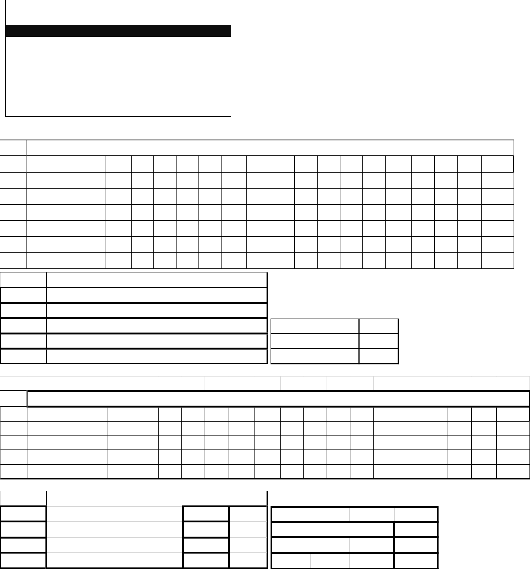
PICKUP OR DELIVERY CHARGES
HARBOR POINTS IN WA
Shipments originating at or destined to the following points not subject to base rates in Tariff RLCA 5000 series, will be
subject to the following charges. These charges shall be in addition to applicable line haul charges from or to point of
transfer.
Zip Code(s)
Rates
98261
Call for Quote 800-535-1984
98281
$150.70 per cwt
$150.70 Minimum
$1,348.30 Maximum
98243, 98245,
98279, 98280,
98297, 98286
& Will Call
See Chart Below
Shipments rated per the table above are subject to a Fuel Surcharge of 12%.
Shipments subject to the minimum charges table above are subject to a Fuel Surcharge of 15%.
Friday Harbor Freight Lines Drop in their trailer See below 98250
50 55 60 65 70 77.5 85 92.5 100 110 125 150 175 200 250 300 400 500
L5C 69.50 69.50 69.50 69.50 82.20 82.20 96.40 96.40 107.20 113.50 157.70 185.60 218.60 257.60 303.30 356.80 495.10 583.10
5C 55.70 55.70 55.70 55.70 65.90 65.90 77.20 77.20 85.80 90.90 126.10 148.60 174.80 206.00 242.70 285.70 396.20 466.50
1M 42.10 42.10 42.10 42.10 52.60 52.60 61.80 61.80 68.60 72.70 100.90 119.00 140.20 165.00 194.20 228.60 317.10 361.90
2M 34.10 34.10 34.10 34.10 39.00 39.00 59.70 59.70 51.60 54.60 76.00 89.20 105.10 123.80 145.70 171.40 237.60 280.00
5M 25.20 25.20 25.20 25.20 29.50 29.50 34.90 34.90 38.70 40.90 56.80 66.70 78.70 92.90 109.20 128.70 178.40 210.20
10M 18.70 18.70 18.70 18.70 22.10 22.10 26.10 26.10 29.00 30.60 42.70 50.20 59.10 69.60 82.00 96.40 134.00 157.50
Rates in dollars and cents per 100 lbs.
Weight
0-99
100-199
200-299
300-399
400+
356.30$
445.20$
Minimum Charge
285.10$
227.90$
182.50$
$90.50
$99.80
$50.80
Notification
Liftgate
Residential
50 55 60 65 70 77.5 85 92.5 100 110 125 150 175 200 250 300 400 500
1M 19.20 19.20 19.20 19.20 20.40 20.40 23.70 23.70 27.40 34.00 34.00 40.90 47.80 54.60 54.60 74.40 74.40 74.40
2M 14.70 14.70 14.70 14.70 15.60 15.60 18.30 18.30 20.70 26.00 26.00 31.20 36.20 41.30 41.30 56.50 56.50 56.50
5M 9.30 9.30 9.30 9.30 9.80 9.80 10.90 10.90 12.70 16.00 16.00 19.00 22.10 25.30 25.30 34.60 34.60 34.60
10M 5.70 5.70 5.70 5.70 6.10 6.10 7.50 7.50 8.20 9.90 9.90 12.20 14.20 16.10 16.10 22.00 22.00 22.00
98070
Rates in dollars and cents per 100 lbs.
Drop in their trailer
See below
Vashon Trucking
Weight
0-250 --- 137.50$
251-500 --- 174.20$
501-750 --- 202.40$
751-1000 --- 231.90$
Minimum Charge
Accessorials:
Residential Delivery $98.70
Extra Man $80.60
Lift Gate $127.00

EFFECTIVE SEPTEMBER 15, 2023
ITEM 752
PICKUP OR DELIVERY SERVICE - AFTER HOURS
Any pickup or delivery, made at the request of the shipper or consignee, to be made after 5:00 PM and/or before 9:00 AM,
Monday thru Friday (See Note), will be considered (After Normal Weekday Hours of Service) and will be subject to the
conditions specified below:
1. Any pickup or delivery after normal weekday hours from 5:00 PM until 9:00 AM will be subject to an extra charge of
$188.10 per hour, subject to a minimum charge of $558.40.
2. These charges must be guaranteed by the party requesting this service or guaranteed to the satisfaction of the carrier
before pickup and/or delivery will be made.
3. Execution of the non-recourse stipulation, Section 7 of the Bill of Lading, on the same shipment will not apply when
shipments are moving under the provisions of this rule.
4. NO discount or reduction will apply to these special prices.
NOTE: Service provided from 12:01 AM Saturday to 7:59 AM Monday and Holidays will be subject to the provisions of
Item 756.
EFFECTIVE SEPTEMBER 15, 2023
ITEM 753
PICKUP OR DELIVERY - PRIVATE RESIDENCES and
NON-COMMERCIAL – LIMITED ACCESS
1. Residential - Private Residences - Shipments picked up at or delivered to Private Residences or Apartments.
Signature Fee applicable. No signature delivery available.
50 55 60 65 70 77.5 85 92.5 100 110 125 150 175 200 250 300 400 500
L5C 69.40 69.40 69.40 69.40 81.30 81.30 98.80 98.80 116.30 132.90 145.10 174.30 203.40 232.50 290.60 348.60 464.70 580.80
5C 55.70 55.70 55.70 55.70 65.00 65.00 79.00 79.00 93.00 102.30 116.30 139.10 162.70 186.10 232.50 278.80 372.10 464.60
1M 42.90 42.90 42.90 42.90 52.30 52.30 63.20 63.20 74.40 81.70 93.00 111.70 130.10 148.40 186.10 222.90 297.70 372.00
2M 33.50 33.50 33.50 33.50 39.20 39.20 47.60 47.60 55.70 61.30 69.90 83.80 97.80 111.70 139.40 167.30 219.70 279.00
5M 24.90 24.90 24.90 24.90 29.40 29.40 35.80 35.80 41.90 46.00 52.50 61.70 73.20 83.80 104.80 120.80 167.30 209.40
10M 18.70 18.70 18.70 18.70 22.00 22.00 26.60 26.60 31.40 34.70 39.20 47.10 54.80 62.60 78.50 94.00 120.80 156.90
Rates in dollars and cents per 100 lbs.
Weight
0-99
100-199
200-299
300-399
400+
593.60$
395.00$
551.80$
356.50$
478.60$
Minimum Charge
$90.70
$94.30
$50.40
Liftgate
Notification
Residential
27960 Ocracoke, NC $69.90
48028 Harsens Island, MI $73.60
11963 SAG HARBOR, NY $95.50
11963 NORTH HAVEN, NY $95.40
11964 SHELTER ISLAND, NY $95.40
11965 SHELTER ISLAND HEIGHTS, NY $95.40

2. Limited Access – non-commercial - Camps, Churches, Construction Sites, Convents, Country Clubs, Estates,
Golf Courses, Farms, Marinas, Military bases, Mini-storage warehouses, Non-Commercial Locations; Nursing homes,
Prisons, Rectory or Schools, Yacht Clubs and other such locations.
3. The charge for either of these deliveries is $13.70 per 100 pounds subject to a minimum charge of $197.70 per
shipment and a maximum charge of $1,339.20 per shipment.
4. Service under this item provided to floors above or below the level accessible to carrier's vehicles only when
elevator or escalator service is available, and labor when necessary to operate it is provided without cost to the carrier.
NOTE 1: The term "Private Residences" shall apply to the entire premises on which a dwelling for living is located, except
will not apply to that portion of the premises where commercial or business activity that involves the sale of merchandise
or services to the walk-in public during normal business hours.
EFFECTIVE SEPTEMBER 15, 2023
ITEM 754
PICKUP OR DELIVERY - CONVENTION CENTERS
1. Shipment originating at or destined to all Convention or Exhibition Facilities, or temporary warehouses, including
but not limited to facilities located at 2200 Consulate Drive, Orlando, FL 32837, 10088 General Drive, Orlando, FL
32824, and 7945 Mandarin Drive, Orlando, FL 32819, shall be subject to NMFC Class 125 Item 154630, or actual
class if higher, with no discount (see Note A for exception), subject to a minimum charge of $494.20 per
shipment.
A. Deliveries to temporary warehouses as referenced above will be rated at NMFC Class 125 Item 154630,
or actual class if higher, with discount.
EXCEPTION or FREIGHT ALL KINDS (FAK) class rating is not permitted.
EFFECTIVE SEPTEMBER 15, 2023
ITEM 755
CALIFORNIA COMPLIANCE SURCHARGE
Shipments originating at, destined to, or within the State of California will be subject to a surcharge of $22.00 per
shipment.
EFFECTIVE SEPTEMBER 15, 2023
.
ITEM 756
PICKUP OR DELIVERY SERVICE - SATURDAYS, SUNDAYS OR HOLIDAYS
(See Note)
1) When consignor or consignee requests carrier pickup or deliver freight on Saturdays, Sundays or Holidays (see Item
110), such service will be subject to $200.80 per man per hour with a minimum charge of $949.00 per man per day,
such charge shall be in addition to all other applicable charges.
2) Time shall be computed upon notification of the driver to the responsible representative of the consignor or consignee
that the vehicle or vehicles are available for loading or unloading at premises of consignor or consignee and shall end
upon completion of loading or unloading and receipt by driver of signed Bill of Lading or receipt for delivery, as the
case may be.
3) Consignor or consignee may request carrier to place or pickup an empty trailer (Vehicles Without Power Units) on
Saturdays, Sundays or Holidays even though the actual pickup and/or delivery of freight may occur on a day other
than Saturdays, Sundays or Holidays. The charge for this service will be $949.00 per day or fraction thereof.
4) The carrier is not obligated to furnish pickup or delivery service on Saturdays, Sundays or Holidays. If a delivery date
is specified on the Bill of Lading and shipping order and it is a Saturday, Sunday or a Holiday, such document must
also indicate that the date is in fact a Saturday, Sunday or Holiday.

5) Charges must be either paid by the party requesting the service or guaranteed to the satisfaction of the carrier before
pickup or delivery will be made.
6) When consignor or consignee or his agent performs loading, unloading or movement of a vehicle within the plant
property of the consignor or consignee on a Saturday, Sunday or Holiday in connection with a vehicle which had
previously been placed on a day which is neither a Sunday or Holiday, the charges in this item will not apply provided
that neither the carrier nor his agent is required to perform any service in connection therewith.
NOTE: When the service as described in this item is performed at the convenience of the carrier, the charges named
herein will not apply.
EFFECTIVE SEPTEMBER 15, 2023
ITEM 757
PICKUP AND DELIVERY SERVICE – HIGH COST SERVICE AREA SURCHARGE
Shipments originating or destined to the following service areas will be subject to a per shipment surcharge. This
surcharge will be in addition to all other applicable rates and charges and will be added to the freight bill as a separate line
item. The surcharge will be billed to and the responsibility of the party who is responsible for payment of the line haul
freight charges.
NEW YORK, NY - SURCHARGE $100.00
ZIP
PRIMARY CITY
ZIP
PRIMARY CITY
10300-10499
NEW YORK, NY
11000-11999
NEW YORK, NY
11963-11965
Additional charges may apply
(see Item 328)
The following zip codes (ZONE 5) will be subject to a $50.00 surcharge:
ZIP
CITY
ZIP
CITY
13635
EDWARDS, NY
81623
EL JEBEL, CO
13639
FINE, NY
81623
MARBLE, CO
13666
NEWTON FALLS, NY
81623
REDSTONE, CO
13670
OSWEGATCHIE, NY
81624
COLLBRAN, CO
13684
DEGRASSE, NY
81624
PLATEAU CITY, CO
13684
RUSSELL, NY
81630
DE BEQUE, CO
59644
TOWNSEND, MT
81631
EAGLE, CO
59647
WINSTON, MT
81632
EDWARDS, CO
13690
STAR LAKE, NY
81633
DINOSAUR, CO
13696
WEST STOCKHOLM, NY
81633
ELK SPRINGS, CO
63432
ARBELA, MO
81635
BATTLEMENT MESA, CO
63442
GRANGER, MO
81635
PARACHUTE, CO
63442
ARBELA, MO
81636
BATTLEMENT MESA, CO
63446
KNOX CITY, MO
81636
PARACHUTE, CO
63458
NEWARK, MO
81637
GYPSUM, CO
63460
NOVELTY, MO
81638
HAMILTON, CO
63501
KIRKSVILLE, MO
81640
MAYBELL, CO
63501
SPRING LAKE, MO
81641
MEEKER, CO
63530
ATLANTA, MO
81642
MEREDITH, CO
63531
BARING, MO
81643
MESA, CO
63533
BRASHEAR, MO
81645
GILMAN, CO

63535
COATSVILLE, MO
81645
MINTURN, CO
63536
DOWNING, MO
81646
MOLINA, CO
63537
EDINA, MO
81647
NEW CASTLE, CO
63538
ELMER, MO
81648
RANGELY, CO
63539
ETHEL, MO
81650
RIFLE, CO
63540
GIBBS, MO
81652
SILT, CO
63541
GLENWOOD, MO
81654
SNOWMASS, CO
63543
GORIN, MO
81655
WOLCOTT, CO
63546
GREENTOP, MO
81656
WOODY CREEK, CO
63547
HURDLAND, MO
82322
BAIROIL, WY
63548
LANCASTER, MO
82327
HANNA, WY
63549
LA PLATA, MO
82327
ELMO, WY
63551
LIVONIA, MO
82327
KORTES DAM, WY
63555
MEMPHIS, MO
82327
LEO, WY
63559
NOVINGER, MO
82329
MEDICINE BOW, WY
63561
QUEEN CITY, MO
82331
RYAN PARK, WY
63563
RUTLEDGE, MO
82331
SARATOGA, WY
63565
UNIONVILLE, MO
82426
GREY BULL, WY
63565
LEMONS, MO
82428
HYATTVILLE, WY
63567
WORTHINGTON, MO
82512
CROWHEART, WY
64655
LUCERNE, MO
82512
BURRIS, WY
64672
POWERSVILLE, MO
82513
DUBOIS, WY
66518
OKETO, KS
82514
FORT WASHAKIE, WY
66541
SUMMERFIELD, KS
82523
PAVILLION, WY
66936
BURR OAK, KS
82620
ALCOVA, WY
66946
HOLLENBERG, KS
82637
GLENROCK, WY
66955
MAHASKA, KS
82637
PARKERTON, WY
66960
NARKA, KS
82637
ROLLING HILLS, WY
66964
REPUBLIC, KS
82642
LOST CABIN, WY
66970
WEBBER, KS
82642
LYSITE, WY
67024
CEDAR VALE, KS
82643
MIDWEST, WY
67028
COATS, KS
82649
SHOSHONI, WY
67028
BELVIDERE, KS
82701
NEWCASTLE, WY
67071
LAKE CITY, KS
82710
ALLADIN, WY
67332
BARTLETT, KS
82712
BEULAH, WY
67334
CHAUTAUQUA, KS
82714
DEVILS TOWER, WY
67342
EDNA, KS
82715
FOUR CORNERS, WY
67361
SEDAN, KS
82715
NEWCASTLE, WY
67648
LUCAS, KS
82720
HULETT, WY
67762
WESKAN, KS
82720
NEW HAVEN, WY
67840
ENGLEWOOD, KS
82729
SUNDANCE, WY
67950
ELKHART, KS
82845
WYARNO, WY
67953
RICHFIELD, KS
82929
LITTLE AMERICA, WY
67954
ROLLA, KS
82930
BEAR RIVER, WY
68821
BREWSTER, NE
82930
EVANSTON, WY
68833
DUNNING, NE
82933
FORT BRIDGER, WY
69023
CHAMPION, NE
82933
PIEDMONT, WY
69023
LAMAR, NE
82934
GRANGER, WY

69026
DANBURY, NE
82936
LONETREE, WY
69030
HAIGLER, NE
82938
GREEN RIVER, WY
69032
HAYES CENTER, NE
82938
MCKINNON, WY
69036
LEBANON, NE
82944
ROBERTSON, WY
69037
MAX, NE
82945
SUPERIOR, WY
69040
PALISADE, NE
83001
HOBACK JUNCTION, WY
69041
PARKS, NE
83001
JACKSON, WY
69045
WAUNETA, NE
83001
JACKSON HOLE, WY
69121
ARTHUR, NE
83002
JACKSON, WY
69125
BROADWATER, NE
83002
JACKSON HOLE, WY
69134
ELSIE, NE
83014
WILSON, WY
69135
ELSMERE, NE
83025
JACKSON, WY
69142
HALSEY, NE
83025
TETON VILLAGE, WY
69152
MULLEN, NE
83101
FONTENELLE, WY
69157
PURDUM, NE.
83101
HAMSFORK, WY
69163
GANDY, NE
83101
KEMMERER, WY
69163
STAPLETON, NE
83111
AUBURN, WY
69166
BROWNLEE, NE
83126
SMOOT, WY
69166
THEDFORD, NE
83127
STAR VALLEY RANCH, WY
69167
TRYON, NE
83127
THAYNE, WY
69169
WALLACE, NE
83235
ELLIS, ID
69211
CODY, NE
83433
ISLAND PARK, ID
69212
CROOKSTON, NE
83433
MACKS INN, ID
69216
KILGORE, NE
83853
PORTHILL, ID
69218
MERRIMAN, NE
85707
DAVIS MONTHAN AFB, AZ
69219
NENZEL, NE
85707
TUCSON, AZ
69333
ASHBY, NE
87013
CUBA, NM
69339
CRAWFORD, NE
87013
PUEBLO PINTADO, NM
69339
FORT ROBINSON, NE
87014
CUBERO, NM
69340
ELLSWORTH, NE
87014
SEBOYETA, NM
69345
HARRISBURG, NE
87027
LA JARA, NM
69346
HARRISON, NE
87034
PUEBLO OF ACOMA, NM
69347
HAY SPRINGS, NE
87036
MOUNTAINAIR, NM
69348
HEMINGFORD, NE
87040
PAGUATE, NM
69350
HYANNIS, NE
87061
TORREON, NM
69354
MARSLAND, NE
87321
RAMAH, NM
69360
RUSHVILLE, NE
87326
GALLUP, NM
69365
WHITECLAY, NE
87326
VANDERWAGEN, NM
69366
WHITMAN, NE
87327
BLACK ROCK, NM
69367
WHITNEY, NE
87327
ZUNI, NM
79780
SARAGOSA, TX
87357
PINEHILL, NM
79785
TOYAH, TX
87357
RAMAH, NM
79837
DELL CITY, TX
87413
BLOOMFIELD, NM
79843
MARFA, TX
87420
SHIPROCK, NM
79847
DELL CITY, TX
87510
ABIQUIU, NM
79847
SALT FLAT, TX
87511
ALCALDE, NM
79851
SIERRA BLANCA, TX
87511
LA VILLITA, NM
79854
VALENTINE, TX
87511
LOS LUCEROS, NM

79855
KENT, TX
87520
CHAMA, NM
79855
VAN HORN, TX
87521
CHAMISAL, NM
80420
ALMA, CO
87521
EL VALLE, NM
80422
BLACK HAWK, CO
87521
OJO SARCO, NM
80424
BLUE RIVER, CO
87522
CHIMAYO, NM
80424
BRECKENRIDGE, CO
87522
CUNDIYO, NM
80425
BUFFALO CREEK, CO
87527
APODACA, NM
80427
CENTRAL CITY, CO
87527
DIXON, NM
80428
CLARK, CO
87528
DULCE, NM
80432
COMO, CO
87528
LUMBERTON, NM
80432
FAIRPLAY, CO
87530
EL RITO, NM
80436
DUMONT, CO
87531
EMBUDO, NM
80438
EMPIRE, CO
87535
GLORIETA, NM
80440
FAIRPLAY, CO
87535
LA CUEVA, NM
80442
FRASER, CO
87537
CHILI, NM
80444
GEORGETOWN, CO
87537
EL DUENDE, NM
80446
GRANBY, CO
87537
HERNANDEZ, NM
80446
GRAND LAKE, CO
87538
ILFELD, NM
80447
GRAND LAKE, CO
87540
GALISTEO, NM
80448
GRANT, CO
87540
LAMY, NM
80449
HARTSEL, CO
87543
LLANO, NM
80451
HOT SULPHUR SPRINGS,
CO
87548
MEDANALES, NM
80452
IDAHO SPRINGS, CO
87549
OJO CALIENTE, NM
80456
FAIRPLAY, CO
87552
LOS PACHECOS, NM
80456
JEFFERSON, CO
87552
PECOS, NM
80459
KREMMLING, CO
87553
PENASCO, NM
80467
OAK CREEK, CO
87553
RIO LUCIO, NM
80468
PARSHALL, CO
87558
RED RIVER, NM
80469
PHIPPSBURG, CO
87560
CORUCO, NM
80471
PINECLIFFE, CO
87560
EN ANCON, NM
80475
SHAWNEE, CO
87560
GONZALES RANCH, NM
80476
SILVER PLUME, CO
87560
RIBERTA, NM
80477
STEAMBOAT SPRINGS, CO
87560
SENA, NM
80478
TABERNASH, CO
87567
SANTA CRUZ, NM
80479
TOPONAS, CO
87567
SANTO NINO, NM
80482
WINTER PARK, CO
87576
TRAMPAS, NM
80483
YAMPA, CO
87578
TRUCHAS, NM
80487
STEAMBOAT SPRINGS, CO
87579
VADITO, NM
80488
STEAMBOAT SPRINGS, CO
87713
CHACON, NM
80497
SILVERTHORNE, CO
87714
CIMARRON, NM
80498
HEENEY, CO
87740
COLFAX, CO
80498
SILVERTHORNE, CO
87740
RATON, CO
80515
DRAKE, CO
87935
ELEPHANT BUTTE, NM
80532
GLEN HAVEN, CO
88009
LORDSBURG, NM
80540
LYONS, CO
88009
PLAYAS, NM
80612
CARR, CO
88020
ANIMAS, NM
80648
NUNN, CO
88020
COTTON CITY, NM

80650
PIERCE, CO
88040
HACHITA, NM
80705
FORT MORGAN, CO
88045
LORDSBURG, NM
80705
LOG LANE VILLAGE, CO
88045
ROAD FORKS, NM
80720
AKRON, CO
88115
DORA, NM
80723
BRUSH, CO
88118
FLOYD, NM
80726
CROOK, CO
88121
HOUSE, NM
80728
FLEMING, CO
88126
PEP, NM
80731
HAXTUN, CO
88132
GARRISON, NM
80733
HILLROSE, CO
88132
ROGERS, NM
80734
HOLYOKE, CO
88213
CAPROCK, NM
80735
HALE, CO
88213
TATUM, NM
80735
IDALIA, CO
88256
LOVING, NM
80736
ILIFF, CO
88260
BUCKEYE, NM
80743
OTIS, CO
88260
LOVINGTON, NM
80744
OVID, CO
88264
MALJAMAR, NM
80745
PADRONI, CO
88265
MONUMENT, NM
80749
SEDGWICK, CO
88301
ANCHO, NM
80758
WRAY, CO
88301
CARRIZOZO, NM
80758
LAIRD, CO
88301
DURAN, NM
80759
YUMA, CO
88301
WHITE OAKS, NM
80801
ANTON, CO
88314
BENT, NM
80807
BURLINGTON, CO
88317
CLOUDCROFT, NM
80810
CHEYENNE WELLS, CO
88325
HIGH ROLLS MOUNTAIN,
NM
80812
COPE, CO
88337
LA LUZ, NM
80822
JOES, CO
88345
RUIDOSO, NM
80828
LIMON, CO
88346
RUIDOSO DOWNS, NM
81038
FORT LYON, CO
88352
TULAROSA, NM
81041
GRANADA, CO
88355
RUIDOSO, NM
81043
HARTMAN, CO
88411
BARD, NM
81044
CADDOA, CO
88411
SAN JON, NM
81044
HASTY, CO
88427
MCALISTER, NM
81047
BRISTOL, CO
88431
NEWKIRK, NM
81047
HARTMAN, CO
90263
MALIBU, CA
81047
HOLLY, CO
90264
MALIBU, CA
81049
KIM, CO
90265
BIG ROCK, CA
81049
VILLEGREEN, CO
90265
CASTELLAMMARE, CA
81055
LA VETA, CO
90265
EL NIDO, CA
81055
CUCHARA, CO
90265
MALIBU, CA
81055
BEAR CREEK, CO
90265
MALIBU BOWL, CA
81057
MCCLAVE, CO
90265
MALIBU PARK, CA
81076
SUGAR CITY, CO
90265
POINT DUME, CA
81081
TRINCHERA, CO
90290
FERNWOOD, CA
81121
ARBOLES, CO
90290
GLENVIEW, CA
81128
CHROMO, CO
90290
OLD CANYON, CA
81138
JAROSO, CO
90290
SYLVIA PARK, CA
81147
PAGOSA SPRINGS, CO
90290
TOPANGA, CA
81149
SAGUACHE, CO
94019
HALF MOON BAY, CA

81152
MESITA, CO
94019
PRINCETON BY THE SEA,
CA
81152
SAN LUIS, CO
94037
MONTARA, CA
81157
PAGOSA SPRINGS, CO
94038
MOSS BEACH, CA
81220
CIMARRON, CO
94044
PACIFICA, CA
81227
MONARCH, CO
97037
MAUPIN, OR
81227
SALIDA, CO
97037
PINE GROVE, OR
81230
DOYLEVILLE, CO
97039
MORO, OR
81230
GUNNISON, CO
97040
MOSIER, OR
81231
GUNNISON, CO
97638
SILVER LAKE, OR
81239
PARLIN, CO
97641
CHRISTMAS LAKE, OR
81252
SILVER CLIFF, CO
97711
ASHWOOD, OR
81252
WESTCLIFFE, CO
97720
BURNS, OR
81252
ROSITA, CO
97720
LAWEN, OR
81253
WETMORE, CO
97730
CAMP SHERMAN, OR
81323
DOLORES, CO
97731
CHEMULT, OR
81325
EGNAR, CO
97731
DIAMOND LAKE, OR
81325
SLICK ROCK, CO
97733
CRESCENT, OR
81330
MESA VERDE, CO
97733
CRESCENT LAKE, OR
81330
MESA VERDE NATIONAL,
CO
97735
FORT ROCK, OR
81334
TOWAOC, CO
97737
GILCHRIST, OR
81401
COLONA, CO
97738
HINES, OR
81401
MONTROSE, CO
97750
MITCHELL, OR
81402
MONTROSE, CO
97758
RILEY, OR
81403
MONTROSE, CO
97761
WARM SPRINGS, OR
81410
AUSTIN, CO
97820
CANYON CITY, OR
81410
ORCHARD CITY, CO
97845
JONH DAY, OR
81413
CEDAREDGE, CO
97865
MOUNT VERNON, OR
81413
GRAND MESA, CO
97873
SENECA, OR
81414
CORY, CO
98620
GOLDENDALE, WA
81414
ORCHARD CITY, CO
98673
WISHRAM, WA
81415
CRAWFORD, CO
98822
ENTIAT, WA
81416
DELTA, CO
98855
NIGHTHAWK, WA
81418
ECKERT, CO
98855
TONASKET, WA
81418
ORCHARD CITY, CO
99121
DANVILLE, WA
81419
HOTCHKISS, CO
99126
EVANS, WA
81420
LAZEAR, CO
99126
KETTLE FALLS, WA
81422
NATURITA, CO
99129
FRUITLAND, WA
81423
NORWOOD, CO
99129
HUNTERS, WA
81424
NUCLA, CO
99137
HUNTERS, WA
81425
OLATHE, CO
99157
NORTHPORT, WA
81427
OURAY, CO
99160
ORIENT, WA
81428
BOWIE, CO
99160
KETTLE FALLS, WA
81428
PAONIA, CO
81431
REDVALE, CO
81432
RIDGWAY, CO
81433
SILVERTON, CO
81434
SOMERSET, CO

81501
GRAND JUNCTION, CO
81502
GRAND JUNCTION, CO
81503
GRAND JUNCTION, CO
81504
FRUITVALE, CO
81504
GRAND JUNCTION, CO
81505
GRAND JUNCTION, CO
81506
GRAND JUNCTION, CO
81507
GRAND JUNCTION, CO
81520
CLIFTON, CO
81521
FRUITA, CO
81523
GLADE PARK, CO
81524
LOMA, CO
81525
MACK, CO
81526
PALISADE, CO
81527
WHITEWATER, CO
81601
GLENWOOD SPRINGS, CO
81602
GLENWOOD SPRINGS, CO
81610
DINOSAUR, CO
81611
ASPEN, CO
81612
ASPEN, CO
81615
SNOWMASS VILLAGE, CO
81620
AVON, CO
81620
BEAVER CREEK, CO
81621
BASALT, CO
81623
CARBONDALE, CO
The following zip codes (ZONE A) will be subject to a $100.00 surcharge:
ZIP
CITY
ZIP
CITY
13420
OLD FORGE, NY
83826
EASTPORT, ID
50424
BUFFALO CENTER, IA
83845
MOYIE SPRINGS, ID
50432
CRYSTAL LAKE, IA
83870
TENSED, ID
50434
FERTILE, IA
83870
SANDERS, ID
50436
FOREST CITY, IA
83874
MURRAY, ID
50444
HANLONTOWN, IA
83874
WALLACE, ID
50448
KENSETT, IA
84023
DUTCH JOHN, UT
50450
LAKE MILLS, IA
84023
GREENDALE, UT
50451
LAKOTA, IA
84046
MANILA, UT
50453
LELAND, IA
84515
CISCO, UT
50459
NORTHWOOD, IA
84515
GREEN RIVER, UT
50465
RAKE, IA
84522
EMERY, UT
50468
ROCKFORD, IA
84530
LA SAL, UT
50473
SCARVILLE, IA
84540
GREEN RIVER, UT
50478
THOMPSON, IA
84540
THOMPSON, UT
50480
TITONKA, IA
84710
ALTON, UT
50484
WODEN, IA
84762
SWAINS CREEK, UT
50517
BANCROFT, IA
85321
AJO, AZ
50522
BURT, IA
85321
WHY, AZ

50524
CLARE, IA
85328
CIBOLA, AZ
50538
FARNHAMVILLE, IA
85341
LUKEVILLE, AZ
50538
RINARD, IA
85357
WENDEN, AZ
50540
FONDA, IA
85360
WIKIEUP, AZ
50543
GOWRIE, IA
85362
YARNELL, AZ
50546
HAVELOCK, IA
85371
POSTON, AZ
50556
LEDYARD, IA
85535
EDEN, AZ
50559
LONE ROCK, IA
85535
PIMA, AZ
50568
NEWELL, IA
85541
GISELA, AZ
50571
PALMER, IA
85541
PAYSON, AZ
50573
PLOVER, IA
85541
STAR VALLEY, AZ
50574
POCAHONTAS, IA
85553
TONTO BASIN, AZ
50581
ROLFE, IA
85554
YOUNG, AZ
50590
SWEA CITY, IA
85601
ARIVACA, AZ
50597
WEST BEND, IA
85609
DRAGOON, AZ
50619
CLARKSVILLE, IA
85632
PARADISE, AZ
50624
DIKE, IA
85632
PORTAL, AZ
50636
GREENE, IA
85632
SAN SIMON, AZ
50653
MARBLE ROCK, IA
85634
GU ACHI, AZ
50653
OAKWOOD, IA
85634
GU OIDAK, AZ
50660
NEW HARTFORD, IA
85634
GU VO, AZ
50670
SHELL ROCK, IA
85634
GUNSIGHT, AZ
52531
ALBIA, IA
85634
PISINEMO, AZ
52531
AVERY, IA
85634
SELLS, AZ
59001
ABSAROKEE, MT
85639
TOPAWA, AZ
59002
ACTON, MT
85901
CARRIZO, AZ
59002
MOLT, MT
85901
SHOW LOW, AZ
59003
ASHLAND, MT
85901
SHUMWAY, AZ
59004
ASHLAND, MT
85911
CIBECUE, AZ
59006
BALLANTINE, MT
85911
SHOW LOW, AZ
59007
BEARCREEK, MT
85920
ALPINE, AZ
59007
WASHOE, MT
85922
BLUE, AZ
59008
BELFRY, MT
85924
CONCHO VALLEY, AZ
59010
BIGHORN, MT
85924
CONCHO, AZ
59011
BIG TIMBER, MT
85930
HAWLEY LAKE, AZ
59012
BIRNEY, MT
85930
MCNARY, AZ
59013
BOYD, MT
85932
NUTRIOSO, AZ
59013
ROBERTS, MT
85936
SAINT JOHNS, AZ
59014
BRIDGER, MT
85939
TAYLOR, AZ
59015
BROADVIEW, MT
85941
WHITERIVER, AZ
59016
BUSBY, MT
85942
SNOWFLAKE, AZ
59018
CLYDE PARK, MT
85942
WOODRUFF, AZ
59019
COLUMBUS, MT
86016
CAMERON, AZ
59022
CROW AGENCY, MT
86016
GRAY MOUNTAIN, AZ
59024
CUSTER, MT
86018
FLAGSTAFF, AZ
59025
DECKER, MT
86018
PARKS, AZ
59026
EDGAR, KS
86020
CAMERON, AZ
59027
EMIGRANT, MT
86020
THE GAP, AZ

59028
FISHTAIL, MT
86021
COLORADO CITY, AZ
59029
FROMBERG, MT
86023
GRAND CANYON, AZ
59030
CORWIN SPRINGS, MT
86023
TUSAYAN, AZ
59030
GARDINER, MT
86024
FLAGSTAFF, AZ
59031
GARRYOWEN, MT
86024
HAPPY JACK, AZ
59032
GRASS RANGE, MT
86028
HOLBROOK, AZ
59033
GREYCLIFF, MT
86028
PETRIFIED NATIONAL FOREST,
AZ
59034
HARDIN, MT
86030
HOTEVILLA, AZ
59036
HARLOWTON, MT
86031
HOLBROOK, AZ
59037
HUNTLEY, MT
86031
INDIAN WELLS, AZ
59038
HYSHAM, MT
86033
BLACK MESA, AZ
59038
SANDERS, MT
86033
KAYENTA, AZ
59041
JOLIET, MT
86034
JEDDITO, AZ
59041
SILESIA, MT
86034
KEAMS CANYON, AZ
59043
LAME DEER, MT
86035
LEUPP, AZ
59046
LAVINA, MT
86039
KYKOTSMOVI VILLAGE, AZ
59050
LODGE GRASS, MT
86039
KYKOTSMOVI, AZ
59052
McLEOD, MT
86040
GREENEHAVEN, AZ
59054
MELSTONE, MT
86040
PAGE, AZ
59055
MELVILLE, MT
86042
FIRST MESA, AZ
59057
MOLT, MT
86042
POLACCA, AZ
59059
MUSSELSHELL, MT
86043
MISHONGNOVI, AZ
59061
NYE, MT
86043
SECOND MESA, AZ
59063
PARK CITY, MT
86043
SHONGPOVI, AZ
59064
POMPEYS PILLAR, MT
86043
TOREVA, AZ
59065
PRAY, MT
86044
TONALEA, AZ
59066
PRYOR, MT
86045
TUBA CITY, AZ
59067
RAPELJE, MT
86046
WILLIAMS, AZ
59068
RED LODGE, MT
86047
DILKON, AZ
59068
LUTHER, MT
86047
WINSLOW, AZ
59069
REED POINT, MT
86053
KAIBITO, AZ
59070
ROBERTS, MT
86053
TONALEA, AZ
59070
FOX, MT
86054
SHONTO, AZ
59070
BOYD, MT
86054
TONALEA, AZ
59071
ROSCOE, MT
86320
ASHFORK, AZ
59072
ROUNDUP, MT
86321
BAGDAD, AZ
59073
ROUNDUP, MT
86331
JEROME, AZ
59073
DELPHIA, MT
86332
KIRKLAND, AZ
59074
RYEGATE, MT
86335
RIMROCK, AZ
59075
SAINT XAVIER, MT
86337
SELIGMAN, AZ
59076
HYSHAM, MT
86342
LAKE MONTEZUMA, AZ
59076
SANDERS, MT
86343
CROWN KING, AZ
59078
SHAWMUT, MT
86411
HACKBERRY, AZ
59079
SHEPHERD, MT
86411
KINGMAN, AZ
59081
COOKE CITY, MT
86431
CHLORIDE, AZ
59081
SILVER GATE, MT
86432
BEAVER DAM, AZ
59082
SPRINGDALE, MT
86432
LITTLEFIELD, AZ

59083
SUMATRA, MT
86433
OATMAN, AZ
59084
TEIGEN, MT
86434
PEACH SPRINGS, AZ
59084
WINNETT, MT
86434
TRUXTON, AZ
59086
WILSALL, MT
86437
KINGMAN, AZ
59087
CAT CREEK, MT
86437
VALENTINE, AZ
59087
WINNETT, MT
86441
DOLAN SPRINGS, AZ
59088
WORDEN, MT
86443
TEMPLE BAR MARINA, AZ
59089
WYOLA, MT
86444
MEADVIEW, AZ
59201
WOLF POINT, MT
86502
CHAMBERS, AZ
59211
ANTELOPE, MT
86502
WIDE RUINS, AZ
59212
BAINVILLE, MT
86503
CHINLE, AZ
59213
BROCKTON, MT
86503
ROUGH ROCK, AZ
59214
BROCKWAY, MT
86504
FORT DEFIANCE, AZ
59215
CIRCLE, MT
86505
GANADO, AZ
59217
CRANE, MT
86505
GREASEWOOD, AZ
59218
CULBERTSON, MT
86505
STEAMBOAT CANYON, AZ
59218
MCCABE, MT
86505
TOYEI, AZ
59219
DAGMAR, MT
86506
HOUCK, AZ
59221
FAIRVIEW, MT
86507
CHINLE, AZ
59222
FLAXVILLE, MT
86507
LUKACHUKAI, AZ
59223
FORT PECK, MT
86508
HOUCK, AZ
59226
FROID, MT
86508
LUPTON, AZ
59230
GLASGOW, MT
86510
PINON, AZ
59230
SAINT MARIE, MT
86511
SAINT MICHAELS, AZ
59231
GLASGOW, MT
86512
SANDERS, AZ
59231
SAINT MARIE, MT
86514
RED MESA, AZ
59240
GLENTANA, MT
86514
TEEC NOS POS, AZ
59241
HINSDALE, MT
86515
WINDOW ROCK, AZ
59242
HOMESTEAD, MT
86520
BLUE GAP, AZ
59243
LAMBERT, MT
86520
PINON, AZ
59247
MEDICINE LAKE, MT
86535
DENNEHOTSO, AZ
59248
NASHUA, MT
86535
TEEC NOS POS, AZ
59250
OPHEIM, MT
86538
CHINLE, AZ
59253
PEERLESS, MT
86538
MANY FARMS, AZ
59254
PLENTYWOOD, MT
86540
GANADO, AZ
59255
POPLAR, MT
86540
NAZLINI, AZ
59256
RAYMOND, MT
86545
CHINLE, AZ
59257
REDSTONE, MT
86545
ROCK POINT, AZ
59258
RESERVE, MT
86547
CHINLE, AZ
59259
RICHEY, MT
86547
ROUND ROCK, AZ
59260
RICHLAND, MT
86556
CHINLE, AZ
59261
SACO, MT
86556
TSAILE, AZ
59263
FOUR BUTTES, MT
87320
GALLUP, NM
59263
SCOBEY, MT
87320
MEXICAN SPRINGS, NM
59270
SIDNEY, MT
87419
NAVAJO DAM, NM
59273
VANDALIA, MT
87513
ARROYO HONDO, NM
59274
VIDA, MT
87514
ARROYO SECO, NM
59275
WESTBY, MT
87517
CARSON, NM

59276
WHITETAIL, MT
87525
TAOS SKI VALLEY, NM
59312
ANGELA, MT
87554
PETACA, NM
59313
BAKER, MT
87564
SAN CRISTOBAL, NM
59315
BLOOMFIELD, MT
87573
TERERRO, NM
59322
COHAGEN, MT
87577
TRES PIEDRAS, NM
59323
COLSTRIP, MT
87580
VALDEZ, NM
59326
FALLON, MT
87581
LAS TABLAS, NM
59327
FORSYTH, MT
87581
VALLECITOS, NM
59333
HATHAWAY, MT
87710
ANGEL FIRE, NM
59336
ISMAY, MT
87710
EAGLE NEST, NM
59337
JORDAN, MT
87712
BUENA VISTA, NM
59338
KINSEY, MT
87712
GOLONDRINAS, NM
59339
LINDSAY, MT
87715
CLEVELAND, NM
59344
PLEVNA, MT
87718
EAGLE NEST, NM
59347
ROSEBUD, MT
87722
GUADALUPITA, NM
59349
TERRY, MT
87723
HOLMAN, NM
59353
WIBAUX, MT
87731
EL PORVENIR, NM
59410
AUGUSTA, MT
87731
MONTEZUMA, NM
59411
BABB, MT
87732
LEDOUX, NM
59412
BELT, MT
87732
MORA, NM
59416
BRADY, MT
87734
OCATE, NM
59417
BROWNING, MT
87735
OJO FELIZ, NM
59417
SAINT MARY, MT
87735
WAGON MOUND, NM
59418
BUFFALO, MT
87736
RAINSVILLE, NM
59422
CHOTEAU, MT
87742
PENDARIES, NM
59424
COFFEE CREEK, MT
87742
ROCIADA, NM
59425
CONRAD, MT
87743
ROY, NM
59427
CUT BANK, MT
87745
LAS VEGAS, NM
59427
SANTA RITA, MT
87745
SAPELLO, NM
59430
DENTON, MT
87750
VALMORA, NM
59432
DUPUYER, MT
87750
WATROUS, NM
59433
DUTTON, MT
87752
WAGON MOUND, NM
59434
EAST GLACIER PARK, MT
87753
WATROUS, NM
59435
ETHRIDGE, MT
87936
GARFIELD, NM
59436
FAIRFIELD, MT
87937
HATCH, NM
59443
FORT SHAW, MT
87937
RODEY, NM
59444
GALATA, MT
87939
MONTICELLO, NM
59446
GERALDINE, MT
87940
RINCON, NM
59446
SQUARE BUTTE, MT
87941
SALEM, NM
59448
HEART BUTTE, MT
88022
ARENAS VALLEY, NM
59450
HIGHWOOD, MT
88022
SILVER CITY, NM
59450
SHONKIN, MT
88023
BAYARD, NM
59451
HILGER, MT
88023
VANADIUM, NM
59452
HOBSON, MT
88026
CENTRAL, NM
59453
GARNEILL, MT
88026
SANTA CLARA, NM
59453
JUDITH GAP, MT
88029
COLUMBUS, NM
59454
KEVIN, MT
88034
FAYWOOD, NM
59456
LEDGER, MT
88036
FORT BAYARD, NM

59457
HEATH, MT
88036
SILVER CITY, NM
59457
LEWISTOWN, MT
88041
HANOVER, NM
59461
LOTHAIR, MT
88041
SAN LORENZO, NM
59462
MOCCASIN, MT
88041
SHERMAN, NM
59463
MONARCH, MT
88042
HILLSBORO, NM
59464
MOORE, MT
88042
KINGSTON, NM
59466
FERDIG, MT
88043
HURLEY, NM
59466
OILMONT, MT
88049
MIMBRES, NM
59467
PENDROY, MT
88053
PINOS ALTOS, NM
59468
POWER, MT
88053
SILVER CITY, NM
59469
RAYNESFORD, MT
88054
RADIUM SPRINGS, NM
59471
ROY, MT
88056
RODEO, NM
59472
SAND COULEE, MT
88061
SILVER CITY, NM
59472
TRACY, MT
88062
SILVER CITY, NM
59474
LOTHAIR, MT
88065
TYRONE, NM
59474
SHELBY, MT
88113
CAUSEY, NM
59477
SIMMS, MT
88114
CROSSROADS, NM
59479
STANFORD, MT
88125
MILNESAND, NM
59479
WINDHAM, MT
88130
ARCH, NM
59480
STOCKETT, MT
88130
PORTALES, NM
59482
SUNBURST, MT
88136
YESO, NM
59483
SUN RIVER, MT
88231
EUNICE, NM
59484
SWEET GRASS, MT
88250
HOPE, NM
59486
VALIER, MT
88252
JAL, NM
59487
VAUGHN, MT
88268
WHITES CITY, NM
59521
BOX ELDER, MT
88339
FLYING H, NM
59522
CHESTER, MT
88339
MAYHILL, NM
59523
CHINOOK, MT
88435
PASTURA, NM
59525
GILDFORD, MT
88435
PUERTA DE LUNA, NM
59530
INVERNESS, MT
88435
SANTA ROSA, NM
59531
JOPLIN, MT
89003
BEATTY, NV
59537
LORING, MT
89007
BUNKERVILLE, NV
59538
MALTA, MT
89008
CALIENTE, NV
59538
WAGNER, MT
89013
GOLDFIELD, NV
59540
RUDYARD, MT
89017
HIKO, NV
59542
TURNER, MT
89020
ARMAGOSA VALLEY, NV
59545
WHITLASH, MT
89022
MANHATTAN, NV
59633
CANYON CREEK, MT
89023
MERCURY, NV
59639
LINCOLN, MT
89028
LAUGHLIN, NV
59640
MARYSVILLE, MT
89029
LAUGHLIN, NV
59641
RADERSBURG, MT
89037
COYOTE SPRINGS, NV
59643
TOSTON, MT
89037
MOAPA, NV
59645
WHITE SULPHUR SPRING, MT
89039
CAL-NEV-ARI, NV
59648
CRAIG, MT
89039
SEARCHLIGHT, NV
59648
WOLF CREEK, MT
89041
CRYSTAL, NV
59710
ALDER, MT
89041
PAHRUMP, NV
59713
AVON, MT
89042
PANACA, NV
59716
BIG SKY, MT
89043
CASELTON, NV

59720
CAMERON, MT
89043
DRY VALLEY, NV
59721
CARDWELL, MT
89043
PIOCHE, NV
59724
DELL, MT
89046
COTTONWOOD COVE, NV
59725
DILLON, MT
89046
NELSON, NV
59725
GRANT, MT
89046
SEARCHLIGHT, NV
59727
DIVIDE, MT
89047
SILVERPEAK, NV
59728
ELLISTON, MT
89048
PAHRUMP, NV
59729
ENNIS, MT
89049
FISH LAKE VALLEY, NV
59731
GARRISON, MT
89049
TONOPAH, NV
59732
GLEN, MT
89060
PAHRUMP, NV
59733
GOLD CREEK, MT
89061
PAHRUMP, NV
59735
HARRISON, MT
89316
EUREKA, NV
59736
JACKSON, MT
89318
MCGILL, NV
59739
LIMA, MT
89319
RUTH, NV
59740
MCALLISTER, MT
89415
HAWTHORNE, NV
59743
MELROSE, MT
89415
WALKER LAKE, NV
59745
NORRIS, MT
89418
IMLAY, NV
59746
DILLON, MT
89418
MILL CITY, NV
59746
POLARIS, MT
89418
UNIONVILLE, NV
59747
PONY, MT
89419
LOVELOCK, NV
59749
SHERIDAN, MT
89419
OREANA, NV
59751
SILVER STAR, MT
89420
LUNING, NV
59752
THREE FORKS, MT
89422
MINA, NV
59752
TRIDENT, MT
89424
NIXON, NV
59754
TWIN BRIDGES, MT
89444
TOPAZ RANCH ESTATES
59755
VIRGINIA CITY, MT
89444
WELLINGTON, NV
59758
W. YELLOWSTONE, MT
89445
PARADISE HILL, NV
59759
WHITEHALL, MT
89445
WINNEMUCCA, NV
59760
WILLOW CREEK, MT
89446
WINNEMUCCA, NV
59761
WISDOM, MT
89831
MOUNTAIN CITY, NV
59762
WISE RIVER, MT
89833
RUBY VALLEY, NV
59820
ALBERTON, MT
89833
SHANTYTOWN, NV
59823
BONNER, MT
89834
TUSCARORA, NV
59823
GREENOUGH, MT
89835
METROPOLIS, NV
59823
POTOMAC, MT
89835
OASIS, NV
59825
CLINTON, MT
89835
WELLS, NV
59825
TURAH, MT
89835
WILKINS, NV
59826
CONDON, MT
89883
WENDOVER, NV
59827
CONNER, MT
89883
WEST WENDOVER, NV
59829
DARBY, MT
91901
ALPINE HEIGHTS, CA
59830
DE BORGIA, MT
91901
ALPINE, CA
59831
DIXON, MT
91901
DEHESA, CA
59832
DRUMMOND, MT
91901
GLEN OAKS, CA
59837
HALL, MT
91901
HIDDEN GLEN, CA
59842
HAUGAN, MT
91901
PALO VERDE, CA
59843
HELMVILLE, MT
91901
RANCHO PALO VERDE, CA
59844
HERON, MT
91901
THE WILLOWS, CA
59845
HOT SPRINGS, MT
91901
VICTORIA, CA

59845
NIARADA, MT
91903
ALPINE, CA
59846
HUSON, MT
91905
BOULEVARD, CA
59848
LONEPINE, MT
91905
LIVE OAK SPRINGS, CA
59853
NOXON, MT
91905
MANZANITA, CA
59854
OVANDO, MT
91905
TIERRA DEL SOL, CA
59856
PARADISE, MT
91906
CAMERON CORNERS, CA
59858
PHILIPSBURG, MT
91906
CAMPO, CA
59859
PLAINS, MT
91906
CANYON CITY, CA
59866
SAINT REGIS, MT
91906
MORENA VILLAGE, CA
59867
SALTESE, MT
91916
DECANSO JUNCTION, CA
59868
SEELEY LAKE, MT
91916
DECANSO, CA
59871
SULA, MT
91916
ECHO DELL, CA
59872
SUPERIOR, MT
91916
GREEN VALLEY FALLS, CA
59873
THOMPSON FALLS, MT
91916
HULBURD GROVE, CA
59874
TROUT CREEK, MT
91917
BARRETT JUNCTION, CA
59911
BIGFORK, MT
91917
DULZURA, CA
59911
SWAN LAKE, MT
91917
ENGINEER SPRINGS, CA
59913
CORAM, MT
91931
GUATAY, CA
59914
DAYTON, MT
91935
INDIAN SPRINGS, CA
59914
PROCTOR, MT
91935
JAMACHA, CA
59915
ELMO, MT
91935
JAMUL, CA
59917
EUREKA, MT
91935
NORTH JAMUL, CA
59918
FORTINE, MT
91962
BOULDER OAKS, CA
59919
HUNGRY HORSE, MT
91962
BUCKMAN SPRINGS, CA
59920
KILA, MT
91962
PINE VALLEY, CA
59921
LAKE MCDONALD, MT
91963
POTRERO, CA
59921
WEST GLACIER, MT
91980
TECATE, CA
59923
LIBBY, MT
91987
TECATE, CA
59925
MARION, MT
92003
BONSAL, CA
59926
MARTIN CITY, MT
92028
DE LUZ, CA
59927
OLNEY, MT
92028
FALLBROOK, CA
59929
PROCTOR, MT
92028
LIVE OAK PARK, CA
59930
REXFORD, MT
92028
PALA MESA VILLAGE, CA
59931
ROLLINS, MT
92028
RAINBOW, CA
59932
SOMERS, MT
92028
SAN LUIS REY HEIGHTS, CA
59933
STRYKER, MT
92028
WINTERWARM, CA
59934
TREGO, MT
92059
PALA, CA
59935
TROY, MT
92061
PALA, CA
59936
WEST GLACIER, MT
92061
PAUMA VALLEY, CA
62017
COFFEEN, IL
92065
BALLENA, CA
62017
EAST FORK, IL
92065
BARONA MESA, CA
62051
IRVING, IL
92065
FERNBROOK, CA
62261
MODOC, IL
92065
IRVING'S CREST, CA
62261
PRAIRIE DU ROCH, IL
92065
RAMONA, CA
63023
DITTMER, MO
92065
ROCK HAVEN, CA
63625
BLACK, MO
92065
ROSEMONT, CA
63625
OATES, MO
92065
SAN DIEGO COUNTRY ES, CA
63629
BUNKER, MO
92065
SHADY DELL, CA

65016
BONNOTS MILL, MO
92065
WITCH CREEK, CA
65016
FRANKENSTEIN, MO
92082
RINCON, CA
65067
PORTLAND, MO
92082
VALLEY CENTER, CA
65085
FOLK, MO
92088
FALLBROOK, CA
65085
WESTPHALIA, MO
92201
BERMUDA DUNES, CA
67057
HARDTNER, KS
92201
CHIRIACO SUMMIT, CA
67143
SUN CITY, KS
92201
INDIO, CA
67423
BEVERLY, KS
92225
BLYTHE, CA
67567
PAWNEE ROCK, KS
92225
EAST BLYTHE, CA
67741
KANORADO, KS
92225
RIPLEY, CA
72434
IMBODEN, AR
92226
BLYTHE, CA
72459
RAVENDEN, AR
92227
BRAWLEY, CA
72460
RAVENDEN SPRINGS, AR
92233
CALIPATRIA, CA
73463
RUBOTTOM, OK
92239
DESERT CENTER, CA
73463
WILSON, OK
92239
EAGLE MOUNTAIN, CA
73526
BLAIR, OK
92256
MORONGO VALLEY, CA
73532
DUKE, OK
92257
BOMBAY BEACH, CA
73537
ELDORADO, OK
92257
NILAND, CA
73538
ELGIN, OK
92259
OCOTILLO, CA
73544
GOULD, OK
92280
BLYTHE, CA
73547
GRANITE, OK
92280
VIDAL JUNCTION, CA
73549
HEADRICK, OK
92280
VIDAL, CA
73550
HOLLIS, OK
92283
FELICITY, CA
73554
MANGUM, OK
92283
WINTERHAVEN, CA
73554
REED, OK
92304
AMBOY, CA
73556
MARTHA, OK
92304
CADIZ, CA
73559
MOUNTAIN PARK, OK
92323
CIMA, CA
73561
OSCAR, OK
92342
HELENDALE, CA
73561
TERRAL, OK
92342
SILVER LAKES, CA
73564
COOPERTON, OK
92364
BAKER, CA
73564
ROOSEVELT, OK
92364
NIPTON, CA
73566
SNYDER, OK
92365
NEWBERRY SPRINGS, CA
73567
STERLING, OK
92368
ORO GRANDE, CA
73569
GRADY, OK
92371
PHELAN, CA
73569
TERRAL, OK
92389
TECOPA, CA
73571
VINSON, OK
93210
COALINGA, CA
73573
SUGDEN, OK
93222
FRAZIER PARK, CA
73573
WAURIKA, OK
93222
PINE MOUNTAIN CLUB, CA
73627
CARTER, OK
93225
FRAZIER PARK, CA
73651
HOBART, OK
93234
HURON, CA
73655
LONE WOLF, OK
93276
TUPMAN, CA
73662
SAYRE, OK
93426
BRADLEY, CA
73664
SENTINEL, OK
93451
CAMP ROBERTS, CA
73673
WILLOW, OK
93451
PARKFIELD, CA
73719
AMORITA, OK
93451
SAN MIGUEL, CA
73722
BURLINGTON, OK
93501
MOJAVE, CA
73722
BYRON, OK
93505
CALIFORNIA CITY, CA
73758
MANCHESTER, OK
93514
BISHOP, CA

73761
NASH, OK
93514
CHALFANT VALLEY, CA
73766
POND CREEK, OK
93514
CHALFANT, CA
73771
WAKITA, OK
93514
LAWS, CA
74531
CALVIN, OK
93514
ROUND VALLEY, CA
74570
STUART, OK
93514
ROVANA, CA
74652
FORAKER, OK
93514
SWALL MEADOWS, CA
74652
SHILDER, OK
93515
BISHOP, CA
74652
WEBB CITY, OK
93516
BORON, CA
74827
ATWOOD, OK
93517
BRIDGEPORT, CA
76388
WEINERT, TX
93518
CALIENTE, CA
76841
FORT MCKAVETT, TX - Inbound
only
93518
HAVILAH, CA
76930
BARNHART, TX - Inbound only
93523
AERIAL ACRES, CA
76932
BEST, TX - Inbound only
93523
EDWARDS AFB, CA
76932
BIG LAKE, TX - Inbound only
93523
EDWARDS, CA
76932
TEXON, TX - Inbound only
93523
NORTH EDWARDS, CA
76935
CHRISTOVAL, TX - Inbound only
93524
EDWARDS AFB, CA
76936
ELDORADO AFS, TX - Inbound
only
93524
EDWARDS, CA
76936
ELDORADO, TX - Inbound only
93526
INDEPENDENCE, CA
76939
KNICKERBOCKER, TX - Inbound
only
93529
JUNE LAKE, CA
76941
MERTZON, TX - Inbound only
93530
KEELER, CA
76941
SHERWOOD, TX - Inbound only
93532
ELIZABETH LAKE, CA
76943
OZONA, TX - Inbound only
93532
LAKE ELIZABETH, CA
76945
ROBERT LEE, TX
93532
LAKE HUGHES, CA
76949
SILVER, TX - Inbound only
93532
LEONA VALLEY, CA
76950
SONORA, TX - Inbound only
93532
SANDBERG, CA
76951
STERLING CITY, TX - Inbound only
93541
LEE VINING, CA
76958
WATER VALLEY, TX - Inbound only
93541
MONO CITY, CA
79001
ADRIAN, TX
93542
LITTLE LAKE, CA
79009
BOVINA, TX
93543
JUNIPER HILLS, CA
79027
DIMMITT, TX
93543
LITTLEROCK, CA
79031
EARTH, TX
93543
SUN VILLAGE, CA
79045
HEREFORD, TX
93545
LONE PINE, CA
79053
LAZBUDDIE, TX
93546
CROWLEY LAKE, CA
79064
OLTON, TX
93546
MAMMOTH LAKES, CA
79082
SPRINGLAKE, TX
93549
CARTAGO, CA
79085
SUMMERFIELD, TX
93549
OLANCHA, CA
79230
DODSON, TX
93552
FOUR POINTS, CA
79237
HEDLEY, TX
93552
JOSHUA HILLS, CA
79240
LELIA LAKE, TX
93552
PALMDALE, CA
79323
DENVER CITY, TX
93555
CHINA LAKE NWC, CA
79325
FARWELL, TX
93555
CHINA LAKE, CA
79326
FIELDTON, TX
93555
RIDGECREST, CA
79330
JUSTICEBURG, TX - Inbound only
93556
RIDGECREST, CA
79331
LAMESA, TX
93560
ROSAMOND, CA
79342
LOOP, TX - Inbound only
93560
WILLOW SPRINGS, CA
79347
MULESHOE, TX
93561
BEAR VALLEY SPRINGS, CA

79351
O 'DONNELL, TX
93561
GOLDEN HILLS, CA
79351
ODONNELL, TX
93561
MONOLITH, CA
79359
SEAGRAVES, TX
93561
STALLION SPRINGS, CA
79360
SEMINOLE, TX
93561
TEHACHAPI, CA
79370
SPUR, TX - Inbound only
93562
ARGUS, CA
79376
TOKIO, TX - Inbound only
93562
TRONA, CA
79377
WELCH, TX - Inbound only
93592
TRONA, CA
79378
WELLMAN, TX - Inbound only
93596
BORON, CA
79379
WHITEFACE, TX - Inbound only
93608
CANTUA CREEK, CA
79383
NEW HOME, TX - Inbound only
93640
MENDOTA, CA
79511
COAHOMA, TX
93665
SOUTH DOS PALOS, CA
79516
DUNN, TX - Inbound only
93667
TOLLHOUSE, CA
79517
FLUVANNA, TX - Inbound only
93668
TRANQUILLITY, CA
79518
GIRARD, TX - Inbound only
93920
BIG SUR, CA
79519
GOLDSBORO, TX
93928
FORT HUNTER LIGGETT, CA
79526
HERMLEIGH, TX
93928
JOLON, CA
79527
IRA, TX
93932
LOCKWOOD, CA
79528
JAYTON, TX - Inbound only
94020
LA HONDA, CA
79529
KNOX CITY, TX
94060
PESCADERO, CA
79532
LORAINE, TX - Inbound only
94074
SAN GREGORIO, CA
79539
O'BRIEN, TX
95043
PAICINES, CA
79543
LONGWORTH, TX
95043
PINNACLES, CA
79543
ROBY, TX
95075
TRES PINOS, CA
79546
ROTAN, TX
95221
ALTAVILLE, CA
79549
DERMOTT, TX
95221
ANGEL'S CAMP, CA
79549
SNYDER, TX
95313
CROWS LANDING, CA
79549
UNION, TX
95317
EL NIDO, CA
79550
SNYDER, TX
95322
GUSTINE, CA
79565
WESTBROOK, TX - Inbound only
95322
SANTA NELLA, CA
79701
MIDLAND, TX - Inbound only
95360
NEWMAN, CA
79702
MIDLAND, TX - Inbound only
95374
STEVINSON, CA
79703
MIDLAND, TX - Inbound only
95595
ZENIA, CA
79704
MIDLAND, TX - Inbound only
95629
FIDDLETOWN, CA
79705
MIDLAND, TX - Inbound only
95714
DUTCH FLAT, CA
79706
MIDLAND, TX - Inbound only
95736
WEIMAR, CA
79707
MIDLAND, TX - Inbound only
95916
BERRY CREEK, CA
79708
MIDLAND, TX - Inbound only
95919
BROWNSVILLE, CA
79710
MIDLAND, TX - Inbound only
95924
CEDAR RIDGE, CA
79711
MIDLAND, TX - Inbound only
95930
CLIPPER MILLS, CA
79712
MIDLAND, TX - Inbound only
95934
CRESCENT MILLS, CA
79713
ACKERLY, TX - Inbound only
95939
ELK CREEK, CA
79714
ANDREWS, TX - Inbound only
95944
GOODYEARS BAR, CA
79718
BALMORHEA, TX
95947
GREENVILLE, CA
79719
BARSTOW, TX - Inbound only
95956
MEADOW VALLEY, CA
79720
BIG SPRING, TX - Inbound only
95979
STONYFORD, CA
79720
VEALMOOR, TX - Inbound only
95981
LAPORTE, CA
79721
BIG SPRING, TX - Inbound only
95981
STRAWBERRY VALEY, CA
79730
COYANOSA, TX - Inbound only
95983
GENESEE, CA

79731
CRANE, TX - Inbound only
95983
TAYLORSVILLE, CA
79733
FORSAN, TX - Inbound only
95984
TWAIN, CA
79734
FORT DAVIS, TX
95984
VIRGILIA, CA
79739
GARDEN CITY, TX - Inbound only
96006
ADIN, CA
79740
GIRVIN, TX - Inbound only
96009
BIEBER, CA
79741
GOLDSMITH, TX - Inbound only
96010
BIG BAR, CA
79742
GRANDFALLS, TX - Inbound only
96013
BURNEY, CA
79743
IMPERIAL, TX - Inbound only
96013
JOHNSON PARK, CA
79744
IRAAN, TX - Inbound only
96015
CANBY, CA
79745
KERMIT, TX - Inbound only
96015
FLETCHER, CA
79748
KNOTT, TX - Inbound only
96016
CASSEL, CA
79749
LENORAH, TX - Inbound only
96020
CHESTER, CA
79752
MCCAMEY, TX - Inbound only
96028
FALL RIVER MILLS, CA
79754
MENTONE, TX - Inbound only
96040
HAT CREEK, CA
79755
MIDKIFF, TX - Inbound only
96046
HYAMPOM, CA
79756
MONAHANS, TX - Inbound only
96048
JUNCTION CITY, CA
79758
GARDENDALE, TX - Inbound only
96048
HELENA, CA
79759
NOTREES, TX - Inbound only
96054
LOOKOUT, CA
79760
ODESSA, TX - Inbound only
96056
MCARTHER, CA
79761
ODESSA, TX - Inbound only
96056
LITTLE VALLEY, CA
79762
NORTH COWDEN, TX - Inbound
only
96061
MILL CREEK, CA
79762
ODESSA, TX - Inbound only
96061
MINERAL, CA
79763
ODESSA, TX - Inbound only
96063
MINERAL, CA
79764
ODESSA, TX - Inbound only
96064
MONTAGUE, CA
79765
ODESSA, TX - Inbound only
96068
NUBIEBER, CA
79766
ODESSA, TX - Inbound only
96101
ALTURAS, CA
79768
ODESSA, TX - Inbound only
96104
CEDARVILLE, CA
79769
ODESSA, TX - Inbound only
96108
DAVIS CREEK, CA
79770
ORLA, TX - Inbound only
96110
EAGLEVILLE, CA
79776
PENWELL, TX - Inbound only
96112
FORT BIDWELL, CA
79777
PYOTE, TX - Inbound only
96115
LAKE CITY, CA
79778
RANKIN, TX - Inbound only
96118
LOYALTON, CA
79781
SHEFFIELD, TX - Inbound only
96124
CALPINE, CA
79782
STANTON, TX - Inbound only
96124
SATTLEY, CA
79783
TARZAN, TX - Inbound only
96125
SIERRA CITY, CA
79786
TOYAHVALE, TX
96126
SIERRAVILLE, CA
79788
WICKETT, TX - Inbound only
96136
WENDEL, CA
79789
WINK, TX - Inbound only
96137
CLEAR CREEK, CA
79839
FORT HANCOCK, TX
96137
LAKE ALMANOR, CA
79846
REDFORD, TX
96137
WESTWOOD, CA
79848
SANDERSON, TX - Inbound only
97011
BRIGHTWOOD, OR
80025
ELDORADO SPRINGS, CO
97011
SALMON, OR
80101
AGATE, CO
97028
GOVERNMENT CAMP, OR
80103
BYERS, CO
97028
TIMBERLINE LODGE, OR
80105
DEER TRAIL, CO
97029
GRASS VALLEY, OR
80106
ELBERT, CO
97041
MOUNT HOOD, OR
80136
STRASBURG, CO
97041
MOUNT HOOD PARKDALE, OR

80423
BOND, CO
97041
PARKDALE, OR
80426
BURNS, CO
97044
ODELL, OR
80433
CONIFER, CO
97049
RHODODENDRON, OR
80433
FOXTON, CO
97049
ZIGZAG, OR
80463
MCCOY, CO
97057
SHANIKO, OR
80466
NEDERLAND, CO
97063
TYGH VALLEY, OR
80474
ROLLINSVILLE, CO
97063
WAMIC, OR
80512
BELLVUE, CO
97065
WASCO, OR
80536
LIVERMORE, CO
97067
WELCHES, OR
80536
RED FEATHER LAKES, CO
97067
WEMME, OR
80536
VIRGINIA DALE, CO
97119
DELLWOOD, OR
80649
ORCHARD, CO
97119
DEWEY, OR
80652
ROGGEN, CO
97119
GASTON, OR
80654
HOYT, CO
97119
LAURELWOOD, OR
80654
WIGGINS, CO
97119
STIMSON MILL, OR
80722
ATWOOD, CO
97119
WAPATO, OR
80732
HEREFORD, CO
97138
GEARHART, OR
80741
MERINO, CO
97138
JEWELL, OR
80741
WILLARD, CO
97138
SEASIDE, OR
80754
STONEHAM, CO
97144
TIMBER, OR
80755
VERNON, CO
97148
COVE ORCHARD, OR
80804
ARRIBA, CO
97148
LUNNVILLE, OR
80805
BETHUNE, CO
97148
YAMHILL, OR
80808
CALHAN, CO
97324
ALSEA, OR
80808
ELLICOTT, CO
97326
BLODGETT, OR
80808
RAMAH, CO
97329
CASCADIA, OR
80809
CASCADE, CO
97342
DETROIT, OR
80809
CHIPITA PARK, CO
97343
EDDYVILLE, OR
80814
DIVIDE, CO
97345
FOSTER, OR
80815
FLAGLER, CO
97350
IDANHA, OR
80816
FLORISSANT, CO
97357
LOGSDEN, OR
80820
GUFFEY, CO
97390
TIDEWATER, OR
80825
KIT CARSON, CO
97407
ALLEGANY, OR
80830
MATHESON, CO
97410
AZALEA, OR
80832
RAHMAH, CO
97416
CAMAS VALLEY, OR
80833
RUSH, CO
97419
CHESHIRE, OR
80834
SEIBERT, CO
97429
DAYS CREEK, OR
80835
SIMLA, CO
97431
DEXTER, OR
80836
STRATTON, CO
97436
ELKTON, OR
80860
VICTOR, CO
97438
FALL CREEK, OR
80861
VONA, CO
97438
JASPER, OR
80863
WOODLAND PARK, CO
97443
GLIDE, OR
80864
YODER, CO
97447
IDLEYLD PARK, OR
80866
WOODLAND PARK, CO
97451
LORANE, OR
81019
COLORADO CITY, CO
97452
LOWELL, OR
81021
ARLINGTON, CO
97463
OAKRIDGE, OR
81023
BEULAH, CO
97466
POWERS, OR
81027
BRANSON, CO
97473
SCOTTSBURG, OR

81029
CAMPO, CO
97476
SIXES, OR
81036
CHIVINGTON, CO
97484
TILLER, OR
81036
EADS, CO
97488
FINN ROCK, OR
81040
GARDNER, CO
97488
VIDA, OR
81064
PRITCHETT, CO
97489
LEABURG, OR
81064
UTLEYVILLE, CO
97489
WALTERVILLE, OR
81069
RYE, CO
97490
WALTON, OR
81073
SPRINGFIELD, CO
97492
WESTFIR, OR
81084
LYCAN, CO
97497
SUNNY VALLEY, OR
81084
TWO BUTTES, CO
97497
WOLF CREEK, OR
81087
VILAS, CO
97520
ASHLAND, OR
81089
FARISTA, CO
97520
LINCOLN, OR
81089
WALSENBURG, CO
97536
PROSPECT, OR
81090
WALSH, CO
97536
UNION CREEK, OR
81126
CHAMA, CO
97539
SHADY COVE, OR
81130
CREEDE, CO
97543
GRANTS PASS, OR
81210
ALMONT, CO
97543
WILDERVILLE, OR
81210
SPRING CREEK, CO
97624
CHILOQUIN, OR
81224
CEMENT CREEK, CO
97627
KENO, OR
81224
CRESTED BUTTE, CO
97639
CHILOQUIN, OR
81225
CRESTED BUTTE, CO
97639
SPRAGUE RIVER, OR
81225
MOUNT CRESTED BUTTE, CO
97640
SUMMER LAKE, OR
81225
SKYLAND, CO
97825
DAYVILLE, OR
81235
LAKE CITY, CO
97833
HAINES, OR
81237
OHIO CITY, CO
97836
HEPPNER, OR
81237
SALIDA, CO
97839
LEXINGTON, OR
81241
PITKIN, CO
97843
IONE, OR
81243
POWDERHORN, CO
97859
MEACHAM, OR
81248
SARGENTS, CO
97869
PRAIRIE CITY, OR
81332
RICO, CO
97913
NYSSA, OR
81411
BEDROCK, CO
98286
SHAW ISLAND, WA
81426
OPHIR, CO
98362
LAKE CRESCENT, WA
81429
PARADOX, CO
98362
PORT ANGELES, WA
81430
PLACERVILLE, CO
98566
NEILTON, WA
81435
MOUNTAIN VILLAGE, CO
98583
SATSOP, WA
81435
TELLURIDE, CO
98605
BINGEN, WA
81649
RED CLIFF, CO
98610
CARSON, WA
82058
GARRETT, WY
98612
CATHLAMET, WA
82058
ROCK RIVER, WY
98612
PUGET ISLAND, WA
82059
GRANITE CANYON, WY
98617
DALLESPORT, WA
82059
HARRIMAN, WY
98637
NAHCOTTA, WA
82083
ARLINGTON, WY
98639
NORTH BONNEVILLE, WA
82083
MCFADDEN, WY
98647
SKAMOKAWA, WA
82083
ROCK RIVER, WY
98648
SKAMANIA, WA
82190
CANYON, WY
98648
STEVENSON, WA
82190
LAKE, WY
98649
TOUTLE, WA
82190
MAMMOTH HOT SPRINGS, WY
98819
CONCONULLY, WA
82190
MAMMOTH, WY
98844
CHESAW, WA

82190
OLD FAITHFUL, WY
98844
MOLSON, WA
82190
YELLOWSTONE PARK, WY
98844
OROVILLE, WA
82210
CHUGWATER, WY
98856
TWISP, WA
82210
DIAMOND, WY
98940
RONALD, WA
82215
HARTVILLE, WY
99105
BENGE, WA
82215
SUNRISE, WY
99136
HAY, WA
82217
HAWK SPRINGS, WY
99136
LACROSSE, WA
82221
LAGRANGE, WY
99138
INCHELIUM, WA
82225
KIRTLEY, WY
99146
LAURIER, WA
82225
LUSK, WY
99147
CRESTON, WA
82225
NODE, WY
99147
LINCOLN, WA
82244
YODER, WY
99333
HOOPER, WA
82301
RAWLINS, WY
99335
KAHLOTUS, WA
82301
CRESTON, WY
99401
ANATONE, WA
82301
FORT STEELE, WY
82301
MUDDY GAP, WY
82301
RINER, WY
82324
ELK MOUNTAIN, WY
82325
ENCAMPMENT, WY
82325
RIVERSIDE, WY
82336
WAMSUTTER, WY
82336
RED DESERT, WY
82336
TIPTON, WY
82411
BURLINGTON, WY
82433
MEETEETSE, WY
82434
OTTO, WY
82441
SHELL, WY
82442
TEN SLEEP, WY
82443
GRASS CREEK, WY
82443
THERMOPOLIS, WY
82501
GAS HILLS, WY
82501
LUCKY MACCAMP, WY
82501
MIDVAL, WY
82501
MORTON, WY
82501
RIVERTON, WY
82501
SAND DRAW, WY
82633
DOUGLAS, WY
82633
ORIN, WY
82635
EDGERTON, WY
82638
CASPER, WY
82638
HILAND, WY
82638
MONETA, WY
82639
KAYCEE, WY
82639
MAYOWORTH, WY
82639
SUSSEX, WY
82640
LINCH, WY
82646
CASPER, WY
82646
NATRONA, WY

82648
POWDER RIVER, WY
82711
ALVA, WY
82721
CARLILE, WY
82721
MOORCROFT, WY
82721
OSHOTO, WY
92721
PINE HAVEN, WY
82723
OSAGE, WY
82730
UPTON, WY
82732
GILLETTE, WY
82732
WRIGHT, WY
82831
ARVADA, WY
82835
CLEARMONT, WY
82837
LEITER, WY
82838
PARKMAN, WY
82844
RANCHESTER, WY
82844
WOLF, WY
82901
ROCK SPRINGS, WY
82901
BITTER CREEK, WY
82901
QUEALY, WY
82922
BONDURANT, WY
82942
POINT OF ROCKS, WY
82942
ROCK SPRINGS, WY
83011
KELLY, WY
83012
JENNY LAKE, WY
83012
MOOSE, WY
83013
MORAN, WY
83112
BEDFORD, WY
83213
ARCO, ID
83218
BASALT, ID
83226
CHALLIS, ID
83229
CHALLIS, ID
83229
COBALT, ID
83243
HOLBROOK, ID
83244
HOWE, ID
83251
MACKAY, ID
83251
CHILLY, ID
83253
MAY, ID
83253
PATTERSON, ID
83255
MOORE, ID
83255
DARLINGTON, ID
83285
SODA SPRING, ID
83285
WAYAN, ID
83311
ALBION, ID
83312
ALMO, ID
83342
ELBA, ID
83342
MALTA, ID
83342
NAF, ID
83342
SUBLETT, ID

83414
ALTA, WY
83415
IDAHO FALLS, ID
83415
SCOVILLE, ID
83429
ISLAND PARK, ID
83463
GIBBONSVILLE, ID
83464
LEADORE, ID
83465
LEMHI, ID
83466
NORTH FORK, ID
83468
TENDOY, ID
83469
NORTH FORK, ID
83469
SHOUP, ID
83542
LUCILE, ID
83547
POLLACK, ID
83549
RIGGINS, ID
83554
WHITE BIRD, ID
83666
PLACERVILLE, ID
83812
CLARKIA, ID
83824
DESMET, ID
The following zip codes (ZONE B) will be subject to a $125.00 surcharge:
ZIP
CITY
ZIP
CITY
59053
MARTINSDALE, MT
88123
LINGO, NM
59053
LENNEP, MT
88123
PORTALES, NM
59252
OUTLOOK, MT
97453
MAPLETON, OR
59465
NEIHART, MT
97480
SWISSOME, OR
59489
WINIFRED, MT
97870
RICHLAND, OR
59916
ESSEX, MT
97834
HALFWAY, OR
79852
LAJITAS, TX
97920
WESTFALL, OR
79852
TERLINGUA, TX
80742
NEW RAYMER, CO
81657
EAST VAIL, CO
81657
VAIL, CO
81657
WEST VAIL, CO
81658
VAIL, CO
83671
WARREN, ID
83677
YELLOW PINE, ID
84018
CROYDON, UT
84022
DUGWAY, UT
84022
TERRA, UT
84028
GARDEN CITY, UT
84038
LAKETOWN, UT
84083
WENDOVER, UT
84083
GREENHAVEN, UT
84083
PARTOUN, UT
84083
TROUT CREEK, UT
84336
SNOWVILLE, UT

84510
ANETH, UT
84512
BLUFF, UT
84531
MEXICAN HAT, UT
84534
MOTEZUMA CREEK, UT
84536
MONUMENT VALLEY, UT
84624
DELTA, UT
84624
DESERET, UT
84624
SUTHERLAND, UT
84624
SUGARVILLE, UT
84624
TOPAZ, UT
84716
BOULDER, UT
84726
ESCALANTE, UT
84734
HANKSVILLE, UT
The following zip codes (ZONE C) will be subject to a $150.00 surcharge:
ZIP
CITY
ZIP
CITY
13331
EAGLE BAY, NY
83827
ELK RIVER, ID
13360
INLET, NY
86036
MARBLE CANYON, AZ
59039
INGOMAR, MT
87943
CHLORIDE, NM
59058
MOSBY, MT
87943
WINSTON, NM
59077
SAND SPRINGS, MT
89404
DENIO, NV
59244
LARSLAN, MT
89405
EMPIRE, NV
59035
FORT SMITH, MT
89409
GABBS, NV
59035
YELLOWTAIL, MT
89412
GERLACH, NV
59314
BIDDLE, MT
89821
BEOWAWE, NV
59316
BOYES, MT
89821
CRESCENT VALLEY, NV
59317
BROADUS, MT
89821
EMIGRANT PASS, NV
59317
SONNETTE, MT
89832
OWYHEE, NV
59341
MILDRED, MT
91934
BANKHEAD SPRINGS, CA
59341
FALLON, MT
91934
JACUMBA, CA
59351
VOLBERG, MT
91948
MOUNT LAGUNA, CA
59354
WILLARD, MT
92004
BORREGO SPRINGS, CA
59441
FOREST GROVE, MT
92004
BORREGO WELLS, CA
59642
RINGLING, MT
92004
DESERT LODGE, CA
59343
OLIVE, MT
92004
OCOTILLO WELLS, CA
63434
BETHEL, MO
92004
THE NARROWS, CA
63435
CANTON, MO
92036
AGUA CALIENTE HOT
SPRINGS, CA
63438
DURHAM, MO
92036
BANNER, CA
63439
EMDEN, MO
92036
CANEBRAKE, CA
63440
EWING, MO
92036
CUYAMACA, CA
63447
LA BELLE, MO
92036
HARRISON PARK, CA
63447
STEFFENVILLE, MO
92036
JULIAN, CA
63448
LA GRANGE, MO
92036
KENTWOOD IN THE PINE,
CA
63450
LENTNER, MO
92036
PASO PICACHO, CA
63451
LEONARD, MO
92036
PINE HILLS, CA
63452
LEWISTOWN, MO
92036
SCISSORS CROSSING, CA

63457
MONTICELLO, MO
92036
SHELTER VALLEY RANCH,
CA
63463
PHILADELPHIA, MO
92036
VALLECITO, CA
63468
SHELBINA, MO
92036
WHISPERING PINES, CA
63469
SHELBYVILLE, MO
92036
WYNOLA, CA
63473
WILLIAMSTON, MO
92060
BIRCH HILL, CA
79324
ENOCHS, TX
92060
LA JOLLA AMAGO, CA
79735
FORT STOCKTON, TX
92060
PALOMAR MOUNTAIN, CA
79735
FT STOCKTON, TX
92066
RANCHITA, CA
79772
PECOS, TX
92066
WARNER SPRINGS, CA
79772
VERHALEN, TX
92070
LAKE HENSHAW, CA
79830
ALPINE, TX
92070
MESA GRANDE, CA
79831
ALPINE, TX
92070
MORETTIS, CA
79845
PRESIDO, TX
92070
SANTA YSABEL, CA
80430
COALMONT, CO
92086
AGUA CALIENTE, CA
80430
WALDEN, CO
92086
EAGLES NEST, CA
80434
COWDREY, CO
92086
OAK GROVE, CA
80473
RAND, CO
92086
PUERTA LA CRUZ, CA
80480
WALDEN, CO
92086
SAN FELIPE, CA
80721
AMHERST, CO
92086
SAN IGNACIO, CA
80729
GROVER, CO
92086
SUNSHINE SUMMIT, CA
80747
PEETZ, CO
92086
WARNER SPRINGS, CA
80802
ARAPAHOE, CO
92309
BAKER, CA
80821
BOYERO, CO
92309
KELSO, CA
80821
HUGO, CO
92328
DEATH VALLEY, CA
80862
WILD HORSE, CO
92332
ESSEX, CA
81522
GATEWAY, CO
92338
LUDLOW, CA
82061
HORSE CREEK, WY
92338
NEWBERRY SPRINGS, CA
82219
JAY EM, WY
92366
MOUNTAIN PASS, CA
82224
LOST SPRINGS, WY
92384
SHOSHONE, CA
83462
CARMEN, ID
93512
BENTON, CA
83467
SALMON, ID
93512
BISHOP, CA
83467
BAKER, ID
93513
BIG PINE, CA
83467
ELK BEND, ID
93522
DARWIN, CA
83802
AVERY, ID
97406
AGNESS, OR
83808
CALDER, ID
97604
CHILOQUIN, OR
97604
CRATER LAKE, OR
97732
CRANE, OR
97752
POST, OR
97817
BATES, OR
97830
FOSSIL, OR
97830
KINZUA, OR
97830
MAYVILLE, OR
97848
KIMBERLY, OR
97856
FOX, OR
97856
LONG CREEK, OR
97856
RITTER, OR
97864
MONUMENT, OR
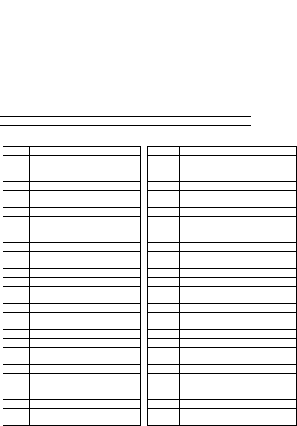
97874
SPRAY, OR
97877
GRANITE, OR
97877
SUMPTER, OR
98267
MARBLEMOUNT, WA
98283
NEWHALEM, WA
98283
ROCKPORT, WA
98288
GROTTO, WA
98288
SKYKOMISH, WA
98833
MAZAMA, WA
98833
WINTHROP, WA
98859
WAUCONDA, WA
98862
WINTHROP, WA
99140
KELLER, WA
99359
STARBUCK, WA
The following zip codes (ZONE E) will be subject to a $200.00 surcharge:
ZIP
CITY
ZIP
CITY
59062
OTTER, MT
94516
CANYON, CA
59225
FRAZER, MT
95223
ARNOLD, CA
59225
LUSTRE, MT
95223
BEAR VALLEY, CA
59311
ALZADA, MT
95223
CAMP CONNELL, CA
59318
BRUSETT, MT
95223
DORRINGTON, CA
59324
EKALAKA, MT
95224
AVERY, CA
59324
MILL IRON, MT
95226
CAMPO SECO, CA
59332
HAMMOND, MT
95226
VALLEY SPRINGS, CA
59345
POWDERVILLE, MT
95229
DOUGLAS FLAT, CA
73015
CARNEGIE, OK
95229
VALLECITO, CA
73021
COLONY, OK
95233
HATHAWAY PINES, CA
73024
CORN, OK
95246
MOUNTAIN RANCH, CA
73030
DAVIS, OK
95247
MURPHYS, CA
73032
DOUGHERTY, OK
95248
RAIL ROAD FLAT, CA
73041
GOTEBO, OK
95251
VALLECITO, CA
73058
MERIDIAN, OK
95310
COLUMBIA, CA
73062
MOUNTAIN VIEW, OK
95311
COULTERVILLE, CA
73096
WEATHERFORD, OK
95311
GREELEY HILL, CA
73425
COUNTYLINE, OK
95321
GROVELAND, CA
73435
FOX, OK
95321
MATHER, CA
73437
GRAHAM, OK
95325
HORNITOS, CA
73438
HEALDTON, OK
95329
LA GRANGE, CA
73442
LOCO, OK
95335
COLD SPRINGS, CA
73443
LONE GROVE, OK
95335
LONG BARN, CA
73444
HENNEPIN, OK
95346
MI WUK VILLAGE, CA
73447
MANNSVILLE, OK
95364
PINECREST, CA
73453
OVERBROOK, OK
95369
SNELLING, CA
73455
RAVIA, OK
95373
SONORA, CA
73456
RINGLING, OK
95373
STANDARD, CA
73458
SPRINGER, OK
95375
PINECREST, CA
73460
TISHOMINGO, OK
95375
STRAWBERRY, CA

73481
RATLIFF CITY, OK
95383
TWAIN HARTE, CA
73487
TATUMS, OK
95601
AMADOR CITY, CA
73488
TUSSY, OK
95638
HERALD, CA
73491
VELMA, OK
95646
KIRKWOOD, CA
73503
FORT STILL, OK
95646
PIONEER, CA
73503
LAWTON, OK
95654
JACKSON, CA
73533
DUNCAN, OK
95654
MARTELL, CA
73534
DUNCAN, OK
95665
PINE GROVE, CA
73536
DUNCAN, OK
95666
PIONEER, CA
73601
CLINTON, OK
95666
SILVER LAKE, CA
73620
ARAPAHO, OK
95669
PLYMOUTH, CA
73622
BESSIE, OK
95680
RYDE, CA
73624
BURNS FLAT, OK
95685
SUTTER CREEK, CA
73625
BUTLER, OK
95685
SUTTER HILL, CA
73626
CANUTE, OK
95686
THORNTON, CA
73628
CHEYENNE, OK
95689
VOLCANO, CA
73628
STRONG CITY, OK
95925
CHALLENGE, CA
73632
CORDELL, OK
96011
BIG BEND, CA
73638
CRAWFORD, OK
96014
CALLAHAN, CA
73639
CUSTER, OK
96023
DORRIS, CA
73639
CUSTER CITY, OK
96027
ETNA, CA
73641
DILL CITY, OK
96027
SAWYERS BAR, CA
73642
DURHAM, OK
96031
FORKS OF SALMON, CA
73644
ELK CITY, OK
96037
GREENVIEW, CA
73645
ERICK, OK
96039
HAPPY CAMP, CA
73646
FAY, OK
96041
HAYFORK, CA
73647
FOSS, OK
96041
PEANUT, CA
73648
ELK CITY, OK
96044
HORNBROOK, CA
73650
HAMMON, OK
96044
HILT, CA
73654
LEEDEY, OK
96049
REDDING, CA
73658
EAGLE CITY, OK
96050
KLAMATH RIVER, CA
73658
OAKWOOD, OK
96050
HORSE CREEK, CA
73659
PUTNAM, OK
96058
MACDOEL, CA
73660
REYDON, OK
96071
OLD STATION, CA
73661
ROCKY, OK
96076
PLANTINA, CA
73663
SEILING, OK
96076
WILDWOOD, CA
73666
SWEETWATER, OK
96085
SCOTT BAR, CA
73667
TALOGA, OK
96086
SEIAD VALLEY, CA
73668
TEXOLA, OK
96091
TRINITY CENTER, CA
73669
THOMAS, OK
96097
YREKA, CA
73706
ENID, OK
96116
LIKELY, CA
73716
ALINE, OK
96119
MADELINE, CA
73717
ALVA, OK
96123
RAVENDALE, CA
73717
AVARD, OK
96132
TERMO, CA
73717
CAPRON, OK
96134
NEWELL, CA
73718
AMES, OK
96134
TIONESTA, CA
73724
CANTON, OK
96134
TULELAKE, CA
73726
CARMEN, OK
97001
ANTELOPE, OR
73727
CARRIER, OK
97001
CLARNO, OR

73728
CHEROKEE, OK
97430
DEADWOOD, OR
73728
LAMBERT, OK
97430
GREENLEAF, OR
73729
CLEO SPRINGS, OK
97880
DALE, OR
73731
DACOMA, OK
97880
UKIAH, OR
73735
DRUMMOND, OK
98068
SNOQUALMIE PASS, WA
73737
FAIRVIEW, OK
98068
SNOQUALMIE, WA
73737
ORIENTA, OK
98236
CLINTON, WA
73738
GARBER, OK
98239
COUPEVILLE, WA
73739
GOLTRY, OK
98249
FREELAND, WA
73741
HELENA, OK
98253
GREENBANK, WA
73743
HILLSDALE, OK
98256
INDEX, WA
73746
HOPETON, OK
98260
LANGLEY, WA
73747
ISABELLA, OK
98277
OAK HARBOR, WA
73749
JET, OK
98278
OAK HARBOR, WA
73753
KREMLIN, OK
98278
WHIDBEY ISLAND NAS, WA
73754
LAHOMA, OK
98852
STEHEKIN, WA
73755
LONGDALE, OK
73760
MENO, OK
73763
OKEENE, OK
73768
RINGWOOD, OK
73770
SOUTHARD, OK
73801
WOODWARD, OK
73802
WOODWARD, OK
73832
ARNETT, OK
73832
HARMON, OK
73834
BUFFALO, OK
73834
SELMAN, OK
73835
CAMARGO, OK
73838
CHESTER, OK
73840
FARGO, OK
73841
FORT SUPPLY, OK
73842
FREEDOM, OK
73843
GAGE, OK
73844
GATE, OK
73844
KNOWLES, OK
73848
LAVERNE, OK
73848
LOGAN, OK
73851
MAY, OK
73852
MOORELAND, OK
73853
MUTUAL, OK
73855
ROSSTON, OK
73857
SHARON, OK
73858
SHATTUCK, OK
73859
VICI, OK
73860
WAYNOKA, OK
73901
ADAMS, OK
73931
BALKO, OK
73932
BEAVER, OK
73932
ELMWOOD, OK

73933
BOISE CITY, OK
73937
FELT, OK
73938
FORGAN, OK
73939
GOODWELL, OK
73942
GUYMON, OK
73944
HARDESTY, OK
73945
HOOKER, OK
73945
OPTIMA, OK
73946
KENTON, OK
73947
KEYES, OK
73949
TEXHOMA, OK
73950
BAKER, OK
73950
TURPIN, OK
73951
TYRONE, OK
74045
MARAMEC, OK
74056
BOWRING, OK
74056
PAWHUSKA, OK
74056
PEARSONIA, OK
74058
BLACKBURN, OK
74058
PAWNEE, OK
74058
SKEDEE, OK
74534
CENTRAHOMA, OK
74556
LEHIGH, OK
74630
BILLINGS, OK
74637
FAIRFAX, OK
74640
HUNTER, OK
74650
RALSTON, OK
74651
RED ROCK, OK
74825
ALLEN, OK
74836
CONNERVILLE, OK
74842
FITTSTOWN, OK
74843
FITZHUGH, OK
74856
MILL CREEK, OK
74871
HARDEN CITY, OK
74871
STONEWALL, OK
79003
ALLISON, TX
79005
BOOKER, TX
79024
DARROUZETT, TX
79034
FOLLETT, TX
79035
FRIONA, TX
79046
HIGGINS, TX
79056
LIPSCOMB, TX
79087
TEXLINE, TX
79095
WELLINGTON, TX
79201
CHILDRESS, TX
79201
KIRKLAND, TX
79201
NORTHFIELD, TX
79233
ESTELLINE, TX
79236
GUTHRIE, TX

79243
MCADOO, TX
79244
MATADOR, TX
79248
PADUCAH, TX
79256
ROARING SPRINGS, TX
79259
TELL, TX
79312
AMHERST, TX
79313
ANTON, TX
79316
BROWNFIELD, TX
79336
LEVELLAND, TX
79336
PETTIT, TX
79338
LEVELLAND, TX
79339
LITTLEFIELD, TX
79344
MAPLE, TX
79345
MEADOW, TX
79346
MORTON, TX
79355
PLAINS, TX
79356
POST, TX
79371
SUDAN, TX
79372
SUNDOWN, TX
79373
TAHOKA, TX
79381
WILSON, TX
79512
COLORADO CITY, TX
79738
GAIL, TX
79832
ALPINE, TX
79832
SUL ROSS, TX
79834
BIG BEND NATIONAL PARK, TX
80740
LINDON, CO
80746
PAOLI, CO
80750
SNYDER, CO
80757
LAST CHANCE, CO
80757
WOODROW, CO
80824
KIRK, CO
81653
SLATER, CO
82063
JELM, WY
82063
LARAMIE, WY
82222
LANCE CREEK, WY
82227
KEELINE, WY
82227
MANVILLE, WY
82229
SHAWNEE, WY
82242
VAN TASSELL, WY
82310
JEFFREY CITY, WY
82310
RAWLINS, WY
82321
BAGGS, WY
82323
DIXON, WY
82332
SAVERY, WY
82520
ATLANTIC CITY, WY
82520
ETHETE, WY
82520
LANDER, WY
82520
SOUTH PASS CITY, WY

82520
SWEETWATER STATION, WY
82725
RECLUSE, WY
83227
CLAYTON, ID
83278
STANLEY, ID
83278
SUNBEAM, ID
83612
COUNCIL, ID
83612
FRUITVALE, ID
83612
BEAR, ID
83612
CUPRUM, ID
83612
GOODRICH, ID
84533
BULLFROG, UT
84533
HALLS CROSSING, UT
84533
HITE, UT
84533
LAKE POWELL, UT
84533
TICABOO, UT
84741
BIG WATER, UT
84741
CANYON POINT, UT
84741
KANAB, UT
86022
FREDONIA, AZ
86022
JACOB LAKE, AZ
89001
ALAMO, NV
89001
RACHEL, NV
89010
DYER, NV
89045
CARVERS, NV
89045
ROUND MOUNTAIN, NV
89310
AUSTIN, NV
89426
PARADISE VALLEY, NV
93205
BODFISH, CA
93206
BUTTONWILLOW, CA
93207
CALIFORNIA HOT SPRINGS, CA
93208
CAMP NELSON, CA
93208
SPRINGVILLE, CA
93220
EDISON, CA
93224
FELLOWS, CA
93226
GLENNVILLE, CA
93237
KAWEAH, CA
93238
KERNVILLE, CA
93240
LAKE ISABELLA, CA
93240
MOUNTAIN MESA, CA
93241
LAMONT, CA
93243
GORMAN, CA
93243
LEBEC, CA
93249
LOST HILS, CA
93251
MCKITTRICK, CA
93252
MARICOPA, CA
93254
CUYAMA, CA
93254
NEW CUYAMA, CA
93255
ONYX, CA
93260
POSEY, CA

93262
SEQUOIA NATIONAL PARK, CA
93265
SPRINGVILLE, CA
93268
TAFT, CA
93271
THREE RIVERS, CA
93283
WELDON, CA
93285
WOFFORD HEIGHTS, CA
93287
WOODY, CA
93519
CANTIL, CA
93519
MOJAVE, CA
93527
INYOKERN, CA
93527
PEARSONVILLE, CA
93531
KEENE, CA
93633
GRANT COVE, CA
93633
KINGS CANYON NATIONAL PARK,
CA
93633
MIRAMONTE, CA
93633
WILSONIA, CA
93642
MONO HOT SPRINGS, CA
93642
SHAVER LAKE, CA
The following zip codes (ZONE G) will be subject to a $250.00 surcharge:
ZIP
CITY
28511
ATLANTIC, NC
28520
CEDAR ISLAND, NC
28524
DAVIS, NC
28528
GLOUCESTER, NC
28531
HARKERS ISLAND, NC
28577
SEALEVEL, NC
28579
SMYRNA, NC
28581
STACY, NC
28589
WILLISTON, NC
59524
DODSON, MT
59526
HARLEM, MT
59527
HAYS, MT
59528
HINGHAM, MT
59529
HOGELAND, MT
59532
KREMLIN, MT
59535
CHINOOK, MT
59535
LLOYD, MT
59544
WHITEWATER, MT
59546
ZORTMAN, MT
59547
ZURICH, MT
79251
QUAIL, TX
80545
RED FEATHER LAKES, CO
83610
CAMBRIDGE, ID

89414
GOLCONDA, NV
89414
MIDAS, NV
89421
MCDERMITT, NV
89425
OROVADA, NV
95915
BELDEN, CA
95915
OROVILLE, CA
97636
PAISLEY, OR
97722
BURNS, OR
97722
DIAMOND, OR
97823
CONDON, OR
98613
CENTERVILLE, WA
98628
KLICKITAT, WA
98635
LYLE, WA
The following zip codes (ZONE H) will be subject to a $275.00 surcharge:
ZIP
CITY
The following zip codes (ZONE I) will be subject to a $300.00 surcharge:
ZIP
CITY
ZIP
CITY
56711
ANGLE INLET, MN
97344
FALLS CITY, OR
59085
TWO DOT, MT
97620
ADEL, OR
59319
CAPITOL, MT
97637
PLUSH, OR
60666
AMF OHARE, IL
97721
PRINCETON, OR
65501
JADWIN, MO
97736
FRENCHGLEN, OR
73558
LAWTON, OK
97814
BAKER CITY, OR
73558
MEERS, OK
97814
BAKER, OR
79223
CEE VEE, TX
97814
KEATING, OR
79314
BLEDSOE, TX
97814
MEDICAL SPRINGS,
OR
79842
MARATHON, TX
97819
BRIDGEPORT, OR
80611
BRIGGSDALE, CO
97824
COVE, OR
80813
CRIPPLE CREEK, CO
97827
ELGIN OR
80827
LAKE GEORGE, CO
97828
ENTERPRISE OR
80827
TARRYALL, CO
97837
HEREFORD, OR
81050
LA JUNTA, CO
97840
OXBOW, OR
81050
TIMPAS, CO
97841
IMBLER OR
81052
LAMAR, CO
97842
IMNAHA, OR
81052
PROWERS, CO
97846
JOSEPH OR
81067
ROCKY FORD, CO
97857
LOSTINE, OR
81071
BRANDON, CO
97883
UNION, OR
81071
SHERIDAN LAKE, CO
97884
UNITY, OR
81071
TOWNER, CO
97885
WALLOWA, OR
81101
ALAMOSA, CO
97902
AROCK, OR
81101
WASHINGTON, CO
97903
BROGAN, OR

81101
GREAT DUNES
NATIONAL PARK, CO
97904
FREWSEY, OR
81102
ALAMOSA, CO
97905
DURKEE, OR
84329
PARK VALLEY, UT
97906
HARPER, OR
86052
FREDONIA, NV
97907
HUNTINGTON, OR
86052
NORTH RIM, NV
97908
IRONSIDE, OR
86435
SUPAI, AZ
97909
JAMIESON, OR
89830
MONTELLO, NV
97910
JORDAN VALLEY, OR
97910
ROME, OR
97911
JUNTURA, OR
97917
RIVERSIDE, OR
The following zip codes (ZONE K) will be subject to a $350.00 surcharge:
ZIP
CITY
83525
DIXIE, ID
83525
ELK CITY, ID
83604
BRUNEAU, ID
83604
GRASMERE, ID
83604
RIDDLE, ID
84026
FORT DUCHESNE, UT
*APPLICABLE TO MINE SITES
ONLY*
84026
OURAY, UT *APPLICABLE TO MINE
SITES ONLY*
84063
RANDLETT, UT *APPLICABLE TO
MINE SITES ONLY*
84078
VERNAL, UT *APPLICABLE TO
MINE SITES ONLY*
84542
WELLINGTON, UT *APPLICABLE
TO MINE SITES ONLY*
89301
CHERRY CREEK, NV *APPLICABLE
TO MINE SITES ONLY*
89301
CURRIE, NV *APPLICABLE TO
MINE SITES ONLY*
89301
ELY, NV *APPLICABLE TO MINE
SITES ONLY*
89315
ELY, NV *APPLICABLE TO MINE
SITES ONLY*
89316
EUREKA, NV *APPLICABLE TO
MINE SITES ONLY*
89319
RUTH, NV *APPLICABLE TO MINE
SITES ONLY*
89414
GOLCONDA, NV *APPLICABLE TO
MINE SITES ONLY*
89414
MIDAS, NV *APPLICABLE TO MINE
SITES ONLY*
89438
VALMY, NV *APPLICABLE TO MINE
SITES ONLY*
89801
ELKO, NV *APPLICABLE TO MINE
SITES ONLY*
89803
ELKO, NV *APPLICABLE TO MINE
SITES ONLY*

89820
BATTLE MOUNTAIN, NV
*APPLICABLE TO MINE SITES
ONLY*
89822
CARLIN, NV *APPLICABLE TO
MINE SITES ONLY*
89835
OASIS, NV *APPLICABLE TO MINE
SITES ONLY*
97751
PAULINA, OR
The following zip codes (ZONE L) will be subject to a $500.00 surcharge:
ZIP
CITY
ZIP
CITY
86544
TEEC NOS POS, AZ
88025
BUCKHORN, NM
86544
RED VALLEY, AZ
88028
CLIFF, NM
87009
CEDARVALE, NM
88038
GILA, NM
87011
CLAUNCH, NM
88039
GLENWOOD, NM
87012
COYOTE, NM
88039
MOGOLLON, NM
87017
GALLINA, NM
88051
MULE CREEK, NM
87018
COUNSELOR, NM
88055
REDROCK, NM
87024
JEMEZ PUEBLO, NM
88055
LORDSBURG, NM
87025
JEMEZ SPRINGS, NM
88318
CORONA, NM
87029
LINDRITH, NM
88321
ENCINO, NM
87029
OJITO, NM
88344
PINON, NM
87037
NAGEEZI, NM
88347
SACRAMENTO, NM
87041
PENA BLANCA, NM
88349
SUNSPOT, NM
87041
COCHITI PUEBLO, NM
88350
CLOUDCROFT, NM
87041
SILE, NM
88350
TIMBERON, NM
87044
PONDEROSA, NM
88353
VAUGHN, NM
87046
REGINA, NM
88354
WEED, NM
87052
SANOT DOMINGO PUEBLO,
NM
88410
AMISTAD, NM
87064
YOUNGSVILLE, NM
88410
HAYDEN, NM
87072
COCHITI PUEBLO, NM
88410
ROSEBUD, NM
87083
COCHITI LAKE, NM
88415
CLAYTON, NM
87310
BRIMHALL, NM
88415
BUEYEROS, NM
87310
GALLUP, NM
88415
STEAD, NM
87313
CROWNPOINT, NM
88416
CONCHAS DAM, NM
87315
FENCE LAKE, NM
88416
TUCUMCARI, NM
87325
TOHATCHI, NM
88419
FOLSOM, NM
87325
NASCHITTI, NM
88421
GARITA, NM
87328
NAVAJO, NM
88422
GLADSTONE, NM
87364
SHEEP SPRINGS, NM
88422
FARLEY, NM
87455
NEWCOMB, NM
88430
NARA VISTA, NM
87461
SANOSTEE, NM
88436
SEDAN, NM
87512
AMALIA, NM
88439
TREMENTINA, NM
87515
CANJILON, NM
89311
BAKER, NV
87516
CANONES, NM
89314
DUCKWATER, NV
87518
CEBOLLA, NM
89317
LUND, NV

87519
CERRO, NM
89825
CONTACT, NV
87524
COSTILLA, NM
89825
JACKPOT, NV
87539
LA MADERA, NM
89826
JARBRIDGE, NV
87551
LOS OJOS, NM
93204
AVENAL, CA
87551
RUTHERON, NM
97021
DUFUR, OR
87551
BRAZOS, NM
97021
FRIEND, OR
87575
TIERRA AMARILLA, NM
97033
KENT, OR
87575
ENSENADA, NM
97413
BLUE RIVER, OR
87583
VILLANUEVA, NM
97413
MCKENZIE BRIDGE,
OR
87711
ANTON CHICO, NM
97635
NEW PINE CREEK, OR
87724
LA LOMA, NM
98602
APPLETON, WA
87729
MIAMI, NM
98619
GLENWOOD, WA
87729
SPRINGER, NM
98650
TROUT LAKE, WA
87730
MILLS, NM
98670
KLICKITAT, WA
87733
MOSQUERO, NM
98670
WAHKIACUS, WA
87733
ALBERT, NM
99322
BICKLETON, WA
87746
SOLANO, NM
87749
UTE PARK, NM
87820
ARAGON, NM
87821
DATIL, NM
87821
HORSE SPRINGS, NM
87824
LUNA, NM
87825
MAGDALENA, NM
87825
ALAMO, NM
87827
PIE TOWN, NM
87829
QUEMADO, NM
87829
RED HILL, NM
87830
RESERVE, NM
The following zip codes (ZONE M) will be subject to a $1,000.00 surcharge:
EFFECTIVE AUGUST 1, 2024
ITEM 757-50
PICKUP AND DELIVERY SERVICE – HIGH COST SERVICE AREA
Shipments originating or destined to the following service areas will be subject to a per shipment surcharge specified for
each high cost service area shown below. These surcharges will be in addition to all other applicable rates and charges,
and will be added to the freight bill as a separate line item. The surcharges apply ONLY to shipments that are rated using
rates, other than the Current R+L Class Rates, and will be billed to and the responsibility of the party who is responsible
for payment of the line haul freight charges.
SAN FRANCISCO, CA (Downtown) – HIGH COST $35.00
ZIP CITY
84313 GROUSE CREEK, UT
97710 FIELDS, OR

ZIP
PRIMARY CITY
ZIP
PRIMARY CITY
94005
BRISBANE, CA
94101-94199
SAN FRANCISCO, CA
94014-94015
DALY CITY, CA
WASHINGTON, DC (METRO) – HIGH COST $50.00
ZIP
PRIMARY CITY
ZIP
PRIMARY CITY
20001-20099
WASHINGTON, DC
20745-20748
OXON HILL, MD
20190-20194
HERNDON & RESTON, VA
20782-20785
HYATTSVILLE, MD
20201-20599
WASHINGTON, DC
22201-22219
ARLINGTON, VA
20701-20737
ANNAPOLIS JUNCTION, MD
22301-22315
ALEXANDRIA, VA
CHICAGO, IL (Downtown) – HIGH COST $35.00
ZIP
PRIMARY CITY
ZIP
PRIMARY CITY
60601-60607
CHICAGO, IL
60661-60661
CHICAGO, IL
60610-60614
CHICAGO, IL
60664-60666
CHICAGO, IL
60622-60622
CHICAGO, IL
60669-60669
CHICAGO, IL
60647-60647
CHICAGO, IL
60671-60681
CHICAGO, IL
60654-60654
CHICAGO, IL
60684-60685
CHICAGO, IL
BOSTON, MA (Metro) – HIGH COST $35.00
ZIP
PRIMARY CITY
ZIP
PRIMARY CITY
02101-02137
BOSTON, MA
02445-02447
BROOKLINE, MA
02201-02227
BOSTON, MA
HOUSTON, TX (Metro) – HIGH COST $35.00
ZIP
PRIMARY CITY
ZIP
PRIMARY CITY
77001-77004
HOUSTON, TX
77019-77020
HOUSTON, TX
77007
HOUSTON, TX
77026
HOUSTON, TX
77009-77011
HOUSTON, TX
NOTE: Provisions of this item shall not be applicable when shipments are rated using R+L Carriers class rates effective
at time of shipment tendered.
EFFECTIVE FEBRUARY 17, 2020
ITEM 757-75
PICKUP AND DELIVERY SERVICE – COASTAL SERVICE AREA SURCHARGE
Shipments originating or destined to the following service areas will be subject to a per shipment surcharge of $21.00.
This surcharge will be in addition to all other applicable rates and charges, and will be added to the freight bill as a
separate line item. The surcharge will be billed to and the responsibility of the party who is responsible for payment of the
line haul freight charges.
ZIP
CITY
ZIP
CITY
94508
ANGWIN, CA
95467
HIDDEN VALLEY LAKE, CA
94515
CALISTOGA, CA
95468
POINT ARENA, CA
94559
NAPA, CA
95469
POTTER VALLEY, CA
94567
POPE VALLEY, CA
95470
REDWOOD VALLEY, CA

94573
RUTHERFORD, CA
95471
RIO NIDO, CA
94922
BODEGA, CA
95480
STEWARTS POINT, CA
94923
BODEGA BAY, CA
95482
UKIAH, CA
94924
BOLINAS, CA
95485
UPPER LAKE, CA
94924
DOGTOWN, CA
95486
SHERIDAN, CA
94925
CORTE MADERA, CA
95486
VILLA GRANDE, CA
94929
DILLON BEACH, CA
95488
WESTPORT, CA
94930
FAIRFAX, CA
95490
LONGVALE, CA
94937
INVERNESS, CA
95490
WILLITS, CA
94938
LAGUNITAS, CA
95493
UPPER LAKE, CA
94939
LARKSPUR, CA
95493
WITTER SPRINGS, CA
94940
MARSHALL, CA
95494
YORKVILLE, CA
94946
NICASIO, CA
95497
GUALALA, CA
94950
OLEMA, CA
95497
SEA RANCH, CA
94955
PETALUMA, CA
95497
THE SEA RANCH, CA
94956
POINT REYES, CA
95501
EUREKA, CA
94970
STINSON BEACH, CA
95502
EUREKA, CA
94971
TOMALES, CA
95503
EUREKA, CA
94972
VALLEY FORD, CA
95511
ALDEROINT, CA
94976
CORTE MADERA, CA
95514
BLOCKSBURG, CA
95410
ALBION, CA
95518
ARCATA, CA
95412
ANNAPOLIS, CA
95519
ARCATA, CA
95415
BOONVILLE, CA
95519
MCKINLEYVILLE, CA
95417
BRANSCOMB, CA
95521
ARCATA, CA
95417
LAYTONVILLE, CA
95521
MCKINLEYVILLE, CA
95418
CALPELLA, CA
95524
BAYSIDE, CA
95418
UKIAH, CA
95525
BLUE LAKE, CA
95419
CAMP MEEKER, CA
95526
BRIDGEVILLE, CA
95420
CASPAR, CA
95526
RUTH, CA
95420
FORT BRAGG, CA
95527
BURNT RANCH, CA
95421
CAZADERO, CA
95528
CARLOTTA, CA
95422
CLEARLAKE, CA
95531
CRESCENT CITY, CA
95423
CLEARLAKE OAKS, CA
95532
CRESCENT CITY, CA
95424
CLEARLAKE PARK, CA
95534
CUTTEN, CA
95425
ASTI, CA
95534
EUREKA, CA
95425
CLOVERDALE, CA
95536
FERNDALE, CA
95426
COBB, CA
95537
FIELDS LANDING, CA
95427
COMPTCHE, CA
95538
FORT DICK, CA
95428
COVELO, CA
95538
CRESCENT CITY, CA
95429
DOS RIOS, CA
95540
FORTUNA, CA
95429
WILLITS, CA
95542
GARBERVILLE, CA
95430
DUNCAN MILLS, CA
95543
GASQUET, CA
95432
ELK, CA
95545
HONEYDEW, CA

95435
FINLEY, CA
95546
HOOPA, CA
95436
FORESTVILLE, CA
95547
HYDESVILLE, CA
95436
MIRABEL PARK, CA
95548
KLAMATH, CA
95437
FORT BRAGG, CA
95549
KNEELAND, CA
95441
GEYSERVILLE, CA
95550
KORBEL, CA
95442
GLEN ELLEN, CA
95551
LOLETA, CA
95443
GLENHAVEN, CA
95552
MAD RIVER, CA
95444
GRATON, CA
95553
MIRANDA, CA
95445
GUALALA, CA
95554
MYERS FLAT, CA
95446
GUERNEVILLE, CA
95555
ORICK, CA
95449
HOPLAND, CA
95556
ORLEANS, CA
95450
FORT ROSS, CA
95558
PETROLIA, CA
95450
JENNER, CA
95559
PHILLIPSVILLE, CA
95451
KELSEYVILLE, CA
95560
REDWAY, CA
95453
LAKEPORT, CA
95562
RIO DELL, CA
95454
LAYTONVILLE, CA
95563
SALYER, CA
95456
LITTLE RIVER, CA
95564
SAMOA, CA
95457
LOWER LAKE, CA
95565
SCOTIA, CA
95458
LUCERNE, CA
95567
SMITH RIVER, CA
95459
MANCHESTER, CA
95568
SOMES BAR, CA
95460
MENDOCINA, CA
95569
REDCREST, CA
95461
LOCH LOMOND, CA
95570
WESTHAVEN, CA
95461
MIDDLETOWN, CA
95570
TRINIDAD, CA
95462
MONTE RIO, CA
95571
WEOTT, CA
95462
RUSSIAN RIVER, CA
95573
WILLOW CREEK, CA
95463
NAVARRO, CA
95585
LEGGETT, CA
95463
PHILO, CA
95587
PIERCY, CA
95464
NICE, CA
95589
WHITETHORN, CA
95465
OCCIDENTAL, CA
95595
ZENIA, CA
95466
PHILO, CA
EFFECTIVE SEPTEMBER 15, 2023
ITEM 769
PREPAYMENT OR GUARANTEE OF CHARGES
Except as provided, shipments will be accepted subject to the following provisions:
1) A prepaid shipment is one on which the charges for transportation service rendered at the request of the consignor,
including charges for any accessorial services performed at the request of the consignor are to be paid by the shipper.
2) A collect shipment is one which the charges for transportation service including accessorial services rendered at the
request of the consignee, or requested by the consignor for the consignee, are to be paid for by the consignee.
3) A shipment on which charges are to be paid by a party other than the consignor or consignee will be accepted
provided that the consignor has established credit with the carrier picking up the shipment at origin and guarantees to
pay the charges if the third party fails to do so within the time allowed under the credit regulations of the Federal
Highway Administration or state regulatory commission. Such a shipment will not be accepted if the consignor
executes Section 7 of the Bill of Lading.
4) If, in the judgment of the carrier picking-up a shipment at origin, the forced sale of the goods would not realize the total
charges due at destination, the shipment must be prepaid.

5) If a shipment is required by Section 4 hereof or by any provisions of this classification to be prepaid, it will be accepted
on a collect basis if the consignor has established credit with the carrier picking up the shipment at origin and the
consignor guarantees to pay the charges if the consignee fails to do so within the time allowed under the credit
regulations of the Federal Highway Administration or state regulatory commission. Such a shipment will not be
accepted as a collect shipment if the consignor executes section 7 of the Bill or Lading.
6) Freight charges must be prepaid on all shipments consigned to or care of Amusement Parks, Trade Shows,
Chautauguas, Fairs or Exhibitions.
7) All freight and accessorial charges on all shipments consigned to federal, state, county or local Governmental Bodies
or agencies, including schools, must be prepaid or guaranteed. (See Note A)
8) All freight and accessorial charges on all shipments of Salvage Parts or Materials must be prepaid or guaranteed.
NOTE A: Not applicable on shipments moving on Government Bills of Lading.
ITEM 770
PREPAYMENT OR COLLECTION OF FREIGHT CHARGES ON EXPORT SHIPMENTS
(See NOTE A)
All freight charges on shipments for export must be prepaid. Paragraph (2) of Item 769 shall not apply.
NOTE A: The provisions of this item will not apply on shipments moving on Government Bills of Lading.
ITEM 775
PRINCIPLES AND PRACTICES FOR THE INVESTIGATION AND DISPOSITION OF FAILURE TO MAKE PAYMENT OF
FREIGHT CHARGES
Failure to make payment of freight charges to subject carriers for services performed as a common carrier by subject
carriers, which subsequently results in legal action (such as collections) taken against the debtor, will be subject to the
following:
1. Forfeiture of all discounts, allowances, commodity rates, brokerage agreements, incentives or any other rate reductions
enjoyed by such debtor, if any, on all unpaid freight bills.
2. A penalty of 125% of the remaining freight bill amount due subject carriers after having added back any forfeitures as
described in Paragraph 1.
3. In addition to the provisions of Paragraphs 1 and 2, debtor will be responsible for attorney fees and/or court costs
associated with or as a result of any collection action.
ITEM 780
PROHIBITED OR RESTRICTED ARTICLES
Sec. 1: PROPERTY EXTRAORDINARY VALUE.
a) Unless otherwise provided, the following property will not be accepted for shipment nor as premiums accompanying
other articles:
Bank bills
Carbon Black
Currency, other than coin (See Note 1)
Deeds
Drafts
Firearms – assembled and unassembled
Jewelry, other than costume or novelty jewelry
Letters, with or without stamps affixed (See Note 2)
Museum exhibits or articles of antiquity (See Note 3)
Notes (bank)
Original works of art (See Note 4)
Postage Stamps
Precious Stones
Revenue Stamps
Valuable papers of any kind

NOTE 1: Monetary coins will not be accepted as premiums with other articles except as authorized in NMFC Item 049987.
NOTE 2: United States Mail will be accepted when the consignor and consignee are United States Post Offices.
NOTE 3: Except antique furniture subject to NMFC Item 100240 or numismatic exhibits subject to Item 63830.
NOTE 4: Except pictures or paintings subject to NMFC Items 100240 and 056165.
b) Articles of extraordinary value will not be accepted for shipment nor as premiums accompanying other articles.
Sec. 2: FREIGHT LIABLE TO DAMAGE OTHER FREIGHT OR EQUIPMENT.
Carriers are not obligated to receive freight liable to impregnate or otherwise damage other freight or carriers' equipment.
Such freight may be accepted and receipted for subject to delay for suitable equipment, or may, for lack of suitable
equipment, be refused.
Sec. 3: CIGARETTES AND TOBACCO PRODUCTS.
The following commodities will not be accepted for shipment: Any vaping products or accessories (including but not
limited to CBD and THC), unless approved by the FDA (cooking oils, etc.).
Cigarettes and tobacco products will be delivered to New York State only when shipped to a New York State (1) licensed
cigarette tax agent, wholesale dealer or registered retail dealer, (2) an export warehouse proprietor or an operator of a
customs bonded warehouse, or (3) person who is an officer, employee or agent of the United States government, New
York State or a department, agency, instrumentality or political subdivision of the United States or New York State, acting
in accordance with his or her official duties. Cigarettes and tobacco products will be delivered from New York State to
another state only when shipped from a New York State licensed cigarette tax agent or when a customer verifies that New
York State cigarette tax has been prepaid and pre-collected. The shipper is solely responsible for compliance with any
applicable federal, state and local laws and regulations, which may vary from state to state.
In the event one of these prohibited articles is inadvertently picked up, Carrier's maximum carrier cargo liability will be
limited to $0.10 per pound or a maximum of $500 per occurrence; whichever is less based of the weight of the lost or
damaged article. All values are in U.S. Dollars unless otherwise noted.
EFFECTIVE JUNE 1, 2023
ITEM 781
PROHIBITED OR RESTRICTED ARTICLES – TRANSBORDER
Prohibited:
• Alcohol/Spirits/Beer/Wine - licensing/excise issue
• Animals/Fish - mounted/stuffed/etc.
• Carbon Black - colorant in manufacturing
• Coins or Currency
• Collections (stamps, coin, cards, etc.)
• Dangerous Goods - cannot move Class 6; Class 2.3; or Class 1 (except 1.4 – acceptable)
• Firearms/Ammunition - licensing issue
• Hazardous Waste - in any class 1-9
• High Value Shipments - we do not offer increased valuation on Transborder shipments. Anything over $5/lb must
be removed from BOL before transit. Customers can get increased coverage through their tariff only.
• Human Remains/Ashes/Parts - cadavers for science, etc.
• Infectious Substances - class 6
• Jewelry/Precious Gems/Metals - Costume jewelry is acceptable as long as no declared value
• Live Plants in LTL quantity
• Marijuana plants/seeds/etc.
• Motor Vehicles - motorcycles, ATVs, Scooters, trailers, snowmobiles, cars, trucks, boats or any type of vehicle that
must adhere to US or Canadian DOT import/export requirements
• Negotiable Instruments - any document guaranteeing the payment of a specific amount of money, either on
demand, or at a set time. (i.e. Cheque)
• Nitrocellulose (guncotton) - class 3 or 4.1
• Tobacco or Tobacco Products - excise issue

Restricted:
• Artwork/Antiques/Statues - can be moved with zero declared value
• Explosives - we can only move 1.4 across the border
• Granite/marble/glass sheets - must be crated and able to stand on their own
• Liftgate/power tailgate service - cannot exceed rated capacity of lift gate; usually 2500 lbs (subject to
dimension restrictions as well)
• Personal Household Goods - can only move at shipper’s risk of loss or damage with no declared value.
(We cannot move used mattresses). A detailed breakdown of every item is required. Southbound must clear
on PAPS every time.
• Radioactive Materials (Class 7) - only move non-placard able amounts – when packaging is ‘excepted’
per 14.38 of the Regs – e.g. smoke detectors, survey equipment.
• Temperature Controlled - we only provide ‘protect from freezing’ service in the winter months;
we cannot provide ambient temperature service on LTL
• TIB, Carnet or E29B Shipments - advance notification and approval required through National
Transborder; cannot move across all gateways on all crossings and may require additional days
service; driver stop charges may apply
• Trade Show Shipments - only when moving to an offsite warehouse or staging area. We will
not deliver to convention locations
EFFECTIVE APRIL 1, 2024
ITEM 810
FREEZABLE PROTECTION
Carrier offers a limited protective service from October 1
st
through April 30
th
against freezing (32 degrees) that depends on
the availability of sufficient and proper equipment and the day of the week on which the shipment will move. Shipper must
contact the local service center to establish in advance whether the service is available. Carrier will use cargo heaters,
blankets, and other equipment as may be available at the local service centers. For this service, Carrier shall charge:
$3.70 per cwt, subject to a minimum charge of $87.90 per shipment.
If a customer has a negotiated rate less than $3.70 per cwt, subject to a minimum charge of $87.90 per shipment, Carrier’s
maximum liability will be $0.70 per pound.
Shipper must clearly mark specifically on the bill of lading: ‘PROTECT FROM FREEZING’
When such requirement is not shown on the bill of lading by the shipper, Carrier will not be liable for loss or damage resulting
from failure to furnish such protection.
Protect from freezing may be withdrawn at Carrier’s discretion wholly or on an individual basis. The carrier will not be
responsible for any damage to shipments containing commodities requiring protection from freezing if said damage is the
result of:
A Delay in delivery because of the need for a delivery appointment
B. Notification prior to delivery
C. Any other delay in delivery not directly attributable to negligence on the part of the carrier
D. If shipment is refused by the consignee
E. If shipper insists on a pickup when carrier has declared an embargo on freezable commodities.
F. BOL required temperature control above freezing.
EFFECTIVE AUGUST 1, 2024
ITEM 811
FREEZABLE EMBARGO GUARANTEED PICK-UP

When a pricing agreement addendum for Freezable embargo guaranteed pick-up is signed, freezables can be picked up
during embargo periods at an extra cost. Restrictions apply including but not limited to heater trailer availability and a
minimum 20’ of trailer loaded with LTL shipments. Only guarantees pickup and does not guarantee transit time or delivery
within a specified time.
For this service, Carrier shall charge:
$7.40 per cwt, subject to a minimum charge of $175.80 per shipment.
EFFECTIVE FEBRUARY 1, 2024
ITEM 820
RECONSIGNMENT
A request for the reconsignment of a shipment will be subject to the following definitions, conditions and charges:
1) DEFINITION OF RECONSIGNMENT:
For the purpose of this rule, the term "reconsignment" will be considered to mean:
a) A change in the name of the consignor or consignee.
b) A change in the place of delivery.
c) Relinquishment of shipment at point of origin (See Note 2).
2) CONDITIONS:
a) Requests for reconsignment must be made or confirmed in writing. The carrier must be satisfied that the party
making the request has the authority to do so. Conditional or qualified requests will not be accepted. Carrier will not
accept disposition instructions printed on the Bill of Lading, shipping order, shipping label or container as authority
to reship, return or reconsign a shipment.
b) Carrier will make diligent effort to execute a request for reconsignment, but will not be responsible if such service is
not affected.
c) All charges applicable to the shipment, whether accrued or accruing, must be paid or guaranteed to the satisfaction
of the carrier before reconsignment will be made.
d) Only entire shipments, not portions of shipments, may be reconsigned.
e) An order for reconsignment of a shipment moving under uniform order Bills of Lading will not be considered valid,
unless and until the original Bill of Lading is surrendered for cancellation, endorsed or exchanged.
f) Instructions for reconsignment of C.O.D. shipments will be accepted only from the consignor.
(3) CHARGES:
Reconsignment, as defined in Paragraph (1), will be subject to the following charges:
ITEM
RULE
UNIT OF
MEASURE
CHARGE
RATE
MINIMUM
CHARGE
MAXIMUM
CHARGE
820
RECONSIGNMENT
(A) Within the same original
delivery terminal
* Standard LTL =
Original charges from origin to
new destination plus the
reconsignment fee
Per
Shipment
Original adjusted
LTL
+ Reconsignment
fee
$4.00 CWT
$55.00
N/A
(B) Outside the original delivery
terminal
* Standard LTL =
Original charges from origin to
point of redirect
AND
New charges from point of
Per
Shipment
Original adjusted
LTL
&
New LTL shipment
+ Reconsignment
fee
$55.00
$55.00
$55.00

redirect to new destination plus
reconsignment fee
NOTE 1: The provisions of governing reconsignment will only apply when carrier receives the request for reconsignment:
(a) Change of destination is within same delivering terminal area.
(b) Change of destination is outside same delivering terminal area.
NOTE 2: Where a request is made by shipper, before a shipment has left carrier's terminal at point of origin, for return of
a shipment to the original place of shipment, or delivery thereof to another carrier at point of origin, or relinquish
possession thereof to shipper or to another carrier at carrier's terminal, such service, if performed, will be subject
to the applicable Pricing Agreement LTL rates from origin to terminal.
NOTE 3: Dock Pick Up – When consignee requests to pick up freight on the dock in lieu of the delivery address,
No additional fee will be added to the freight charge.
EFFECTIVE SEPTEMBER 15, 2023
ITEM 830
REDELIVERY
When a shipment is tendered for delivery and through no fault of the carrier such delivery cannot be accomplished, no
further delivery will be made except upon request.
Redelivery will be subject to the following provisions:
1. If redelivery is requested to the original consignee an additional charge will be made for the final delivery.
Subject to additional fuel surcharge.
2. All charges accruing under the provisions of this item must be paid or guaranteed to the satisfaction of the
carrier, by the party or parties requesting redelivery before the shipment is redelivered.
ITEM
RULE
UNIT OF
MEASURE
CHARGE
RATE
MINIMUM CHARGE
MAXIMUM
CHARGE
830
REDELIVERY
Per Shipment
Original charges
plus
redelivery fee
(Subject to
additional fuel
surcharge)
$4.00
CWT
$ 55 (Subject to
additional fuel
surcharge)
N/A
EFFECTIVE SEPTEMBER 15, 2023
ITEM 845
REFERENCE TO TARIFFS, CLASSIFICATIONS AND PORTIONS THEREOF
Where reference is made to tariffs, classifications or portions thereof such reference will include amendments to or
successive reissues of such tariffs, classifications or portions thereof.
ITEM 860
UNDELIVERED SHIPMENTS
(Return to Origin of Undelivered Shipments)
Undelivered shipments that are returned to the initial shipper will be subject to applicable rates and charges in effect from
the point of return on the date of return.

ITEM 880
TRUCK SEALING OR LOCKS
(Sealing of Trucks)
Except as otherwise provided in Item 470 (Control and Exclusive Use of Vehicle) or in individual rate items, all Seals or
Locks applied to vehicles may be removed at the option of the carrier over whose line such vehicle is moving, for the
purpose of adding or transferring freight for better utilization of equipment or for the purpose of inspection of lading,
stowing or equipment.
ITEM 882
SEGREGATING CHARGES
When shipments tendered for distribution are loaded according to sizes, brands, flavors and/or other distinguishing
characteristics, rather than by lots or units destined to each consignee, a segregating charge of 430 cents per 100
pounds, subject to a minimum charge of $133.40 per shipment sorted or segregated. This charge will be in addition to all
other applicable rates and charges.
EFFECTIVE SEPTEMBER 15, 2023
ITEM 883
SHIPMENTS TENDERED AS A TRUCKLOAD
(See Note A)
Except on shipments for which Exclusive Use of Vehicle is requested, when a shipment is tendered to carrier and Bill of
Lading is so marked "Tendered as a Truckload", the applicable TL rate will apply at actual or minimum weight, whichever
is greater, and the TL rate will not alternate with the LTL rate. Such shipments will be entitled to privileges normally
afforded in rules and regulations pertaining to TL shipments, and will not be governed by rules and regulations pertaining
to LTL shipments. When shipment is tendered to carrier, under Bill of Lading marked "Tendered as a Truckload", and
shipment has begun its movement to destination, corrected Bill of Lading will not be accepted to remove the TL
application.
NOTE A: Where there is more than one VOL or TL rate published, that VOL or TL rate and its accompanying minimum
weight (but not in excess of 40M) producing the highest charge will apply.
ITEM 892
SPECIAL SERVICES - QUOTATION OF ESTIMATED CHARGES
1. When carrier has furnished, either orally or in writing, an estimate of published tariff charges, such estimate will be
given on the basis of effective published tariff provisions as applies to those facts concerning shipments which are
made known to the carrier.
2. Estimates of freight charges are furnished as a convenience to shipping public and represent nothing more than an
approximation of freight charges which will NOT be binding on either carrier or shipper.
3. All transportation charges on a shipment will be assessed on basis of published tariff provisions legally in effect at time
of shipment as applied to commodity shipped and transportation and related services performed in connection
therewith and as governed by the Bill of Lading.
ITEM 900
STOPPING OF TRUCKLOAD SHIPMENTS FOR PARTIAL LOADING
AND/OR PARTIAL UNLOADING
Except as otherwise provided herein, shipments subject to truckload rates and truckload minimum weights, received from
one shipper at one point at one time for one consignee at one destination and covered by one Bill of Lading, may be
stopped for partial loading and/or partial unloading, (not both) subject to the following provisions:
1. Stop Offs Permitted:
(a) After initial pickup stop at origin and prior to final delivery stop at destination, a shipment may be stopped for the
purpose of picking up or delivering (not both) component parts of a single shipment at origin, at points en route to
destination, or at destination.

(b) Pickup or delivery service may be performed at additional loading or unloading sites at origin, destination or
intermediate stop off points within the continuous plant property or premises of the party receiving the service
provided the pickup or delivery sites are not intersected by more than one public thoroughfare. A vehicle transfer
charge of $290.20 will be assessed for each transfer of vehicle from one loading or unloading site to another.
Pickup or delivery service between loading or unloading site separated by more than one public thoroughfare will
be governed by other stop off provisions in this item.
2. Limitations:
(a) Except as provided in Paragraph 1 (b), each stop off is limited to one placement of the truck in accordance with
Item 750 (Pickup or Delivery Service).
(b) Stop offs for partial loading or partial unloading WILL NOT be permitted on shipments moving "COD", "Inbond", "To
Order", "Order Notify", "Order Care of", nor on which Section 7 of the Bill of Lading has been executed.
(c) The substitution of freight for that originally loaded or any exchange of contents at a point or place of stop off is
prohibited.
(d) All of the component parts of a shipment must be loaded and in transit before any stop is made for partial
unloading.
3. Stop Off Charges:
(a) The initial pickup and the final delivery stop are not subject to stop off charges.
(b) Except as provided in Paragraphs 1(b) and 3(a), each stop for either partial loading or partial unloading, but not
both on the same shipment, will be subject to a stop off charge of $290.20 per stop.
4. Line Haul Charges: Line Haul charges will be determined as follows:
(a) Shipment will be rated as if the entire shipment moved from each place where any portion of the shipment is picked
up to each place where any portion of the shipment is delivered and the highest of such charges will apply to the
entire shipment. In determining charges, apply rates in effect on date of shipment from point of origin.
(b) If the total distance from initial origin to final destination via the stop off point or points exceed 115 percent of the
shortest mileage from initial origin to final destination, that distance in excess of 115 percent will be charged for at
the rate of 730 cents per mile. All mileages shall be computed by use of otherwise applicable tariff provisions. The
greatest mileage between any point of loading and any point of unloading will determine initial origin and final
destination.
5. Prepayment of Charges:
All charges MUST BE PREPAID by consignor and only one freight bill will be issued for the entire shipment. However,
charges may be collected when they are guaranteed by the consignor and so noted on the Bill of Lading at time of
shipment. (Section 7 of Bill of Lading may NOT be executed!). All charges to be collected from the consignee at final
destination.
6. Failure to Deliver Stop Off Freight:
When Bill of Lading requires stop off to unload component part of the shipment and carrier is unable during business
hours to effect delivery of such freight at the point or place of stop off, that undelivered portion of such shipment shall
then be subject to rules and regulations governing unclaimed freight, storage and redelivery of freight, to the extent
that such services are applicable.
7. Marking or Tagging Shipments:
Except where shipment consists of identical packages or pieces, or where the various lots of freight comprising the
shipment are of such nature as to be easily identified and segregated, each piece or package in any shipment stopped
for partial unloading must be plainly and durably marked, stenciled or tagged by shipper in such manner that each lot
of freight intended for delivery at a particular point or place of stop off will be readily distinguishable from all other
freight in the shipment.
8. Stop Off Handled in Separate Vehicles:
For carrier's convenience, any portion of the shipment may be picked up, transported, or delivered, in separate trucks
and all portions of the shipment need not be transported through the stop off point or points.
9. Shipping Instructions:
a) Arrangements for any stop off service provided in this item must be made with the originating carrier before
shipment, or any portion thereof, is tendered for transportation.
b) The entire portion of shipment to be picked up must be available for pickup at time of tender.
c) The shipper must tender the part lots in the order required by the carrier.
d) The party or parties authorized and designated by the shipper to accept or tender freight at a point or place of stop
off may be the same or other than the billed consignee.
e) The Bill of Lading shall designate the following:
1) Stop off point or points and places;
2) The weight, quantities, marking and description of articles to be loaded or unloaded;
3) The name and address of the party authorized to tender freight or to accept freight for unloading at point or place
of stop off.
EFFECTIVE SEPTEMBER 15, 2023

ITEM 910
STORAGE
Freight held in carrier's possession by reason of an act or omission of the consignor or owner, or for customs clearance or
inspection, and through no fault of the carrier, will be considered stored immediately and will be subject to the following
provisions:
1. Storage charges on freight awaiting line haul transportation will begin at 7:00 AM, the day after freight is received by
carrier.
2. Storage charges on undelivered freight will begin at 7:00 AM the first business day after notice of arrival has been
given, except no charges under this item will be made when actual tender of delivery is made within 24 hours after
such notice of arrival has been given.
(a) The term "business day" as used in this item means Monday through Friday, excluding Holidays.
(b) When carrier has been given instructions at time of shipment or prior to giving notice of arrival, that consignee
will not accept freight for more than 24 hours, storage charges will begin at 7:00 AM the first business day after
arrival at carrier's destination terminal.
(c) When carrier notifies consignee at 11:59 AM or earlier on the day freight is ready to be delivered and the
consignee refuses to, or does not accept delivery on the day notified, storage charges as provided in Paragraph
4 of this item will begin from the time consignee was notified, and the provisions of Paragraph 2 of this item will
not apply on shipments subject to detention as provided in Item 502.
3. Freight, other than that provided in Paragraph 4, stored in carrier's possession, will be assessed a charge of 580
cents per 100 pounds or fraction thereof, subject to the following minimum and maximum charges:
MINIMUM CHARGES: $106.70 per shipment per each 24 hours, but not less than $106.70 per shipment.
MAXIMUM CHARGES:
PERIOD CHARGES
For the first 24 hours or
fraction thereof………………………………………$133.40 Per shipment or
For the second 24 hours or per vehicle if
fraction thereof………………………………………$200.80 more than one
For the third and each vehicle is used
succeeding 24 hours or to transport the
fraction thereof………………………………………$267.70 shipment.
4. Freight stored in carrier's possession which is subject to truckload rates or which is subject to Exclusive Use of Vehicle
or Capacity Load provisions (See Item 390 and Item 470), will be assessed the following charges:
PERIOD CHARGES
For the first 24 hours or
fraction thereof………………………………………$ 133.40 Per shipment or
For the second 24 hours or per vehicle if
fraction thereof………………………………………$200.80 more than one
For the third and each vehicle is used
succeeding 24 hours or to transport the
fraction thereof……………………………….……. $267.70 shipment.
5. Storage charges under this item will end when carrier is enabled to deliver or transport the freight as a result of action
by the consignee, consignor, owner or Customs Official.
6. Storage charges under this item will not apply on the day carrier places the freight in a public warehouse. When
carrier does place the freight in a public warehouse, the following charges will be assessed:
970 cents per 100 pounds, subject to a minimum charge per shipment of $94.10 and a maximum charge of $1,183.40
per shipment or per vehicle if more than one vehicle is used to transport the shipment.
EFFECTIVE SEPTEMBER 15, 2023
ITEM 940
TERMINAL AREAS, APPLICATION OF RATES FROM AND TO
(See Notes A and B)
1. INCORPORATED MUNICIPALITIES
Except as otherwise provided in this tariff or in tariffs governed by this tariff, rates and rules will apply from and to
points named and points and places within the corporate limits of that municipality and additionally from and to the
following points, places and areas:
a) All unincorporated areas within two miles of the corporate limits of the specified municipality if it has a population of
less than 2,500; within three miles if it has a population 2,500 or more, but less than 25,000; within four miles if it
has a population of 25,000 or more, but less than 100,000; and within five miles if it has a population of 100,000 or
more. Distances referred to are airline distances and populations are as reported by the last federal decennial
census.
b) All places in any other incorporated municipality any part of which is located within the limits described in sub-
paragraph (a) of this item.
c) All places in any other incorporated municipality which is wholly surrounded, or wholly surrounded except for a
water boundary, by any municipality included under the terms of sub-paragraph (b) of this item.
2. UNINCORPORATED COMMUNITIES
Except as otherwise provided in this tariff or in tariffs governed by this tariff, rates and rules will apply from and to
points named, and additionally from and to places and areas as follows:
d) All places within two and one-half miles by air line of the post office of the same name in such unincorporated
community if the community has a population of less than 2,500; within four miles if it has a population of 2,500 but
less than 25,000; and within five and one-half miles if it has a population of 25,000 or more. If the population of the
community is reported in the last federal decennial census, the population so reported will govern in applying this
sub-paragraph. If the community does not have a post office of the same name, distances will be measured from
the generally recognized business center.
e) All places in any incorporated municipality any part which is within the limits described in sub-paragraph (d) of this
item.
f) All points in any other incorporated municipality which is wholly surrounded, or wholly surround except for a water
boundary, by any municipality included under the terms of sub-paragraph (e) of this item.
NOTE A: The provisions of this item are not applicable in establishing rates from or to points from or to which rates (either
class or commodity) are specifically published, either in this tariff or in other tariffs on file.
NOTE B: If the place of collection or delivery lies within the pick-up and delivery limits of two or more points of origin or
destination, the rate applicable will be that from or to the points from or to which the lower or lowest rate is
provided.
ITEM 950
TERMINAL CHARGES AT PORTS
Unless otherwise provided, the rates and charges published in tariffs governed by this tariff do not include wharf age,
usage, loading or unloading charges, or any other port terminal charges at piers, wharves, dockside terminals or
warehouses, and carrier will not absorb said charges.
ITEM 955
THIRD PARTY BILLING (See Note)
When the shipper or consignee elect "Third Party Billing", this carrier will accept these conditions subject to the provisions
of all applicable rules and tariffs. However, the allowances, discounts or commodity rates published in tariffs governed by
this rules tariff WILL NOT APPLY when the "Third Party Billing" information is omitted or left off the Bill of Lading.
NOTE: Shipments made subject to the provisions of this item must be billed as "Prepaid".
ITEM 957
TOLLS-CHARGES
When there is no other access to a pick-up or delivery site except via a toll road or bridge the following charges will apply.
a) Pick-up Site:
Current toll charge will be added to all other lawful charges.
b) Delivery Site:
Current toll charge will be added to all other lawful charges.
ITEM 959
TRANSFER OF LADING
1. When shipments subject to truckload or volume rates cannot be picked up with the vehicle to be used in transporting
the shipments over the highway, and the carrier is required to render pickup service with a different vehicle, such
shipments will be subject to the charges in Paragraph 4, in addition to all other applicable charges. These charges will
be collected from the consignor.
2. When shipments subject to truckload rates cannot be delivered with the vehicle used in transporting the shipment over
the highway, the carrier will notify the consignee of this fact. If the consignee requests the carrier to render delivery
service with a different vehicle, such shipments will be subject to the charges in Paragraph 4 in addition to redelivery
charges when performed, and all other applicable charges. Unless the Bill of Lading is specifically endorsed to show
prepayment of these charges, they will be collected from the consignee.
3. When consignor or consignee requests that shipments subject to truckload rates be picked up or delivered to a vehicle
other than the vehicle used in transporting the shipment over the highway, the charges in Paragraph 4 will apply.
Unless Bill of Lading is specifically endorsed to show prepayment of these charges, they will be collected from the
party requesting the service.
4. Each vehicle required for original pickup and/or final delivery will be considered a separate transfer. The charge for the
weight on each vehicle will be 310 cents per 100 pounds subject to a minimum charge of $445.60.
EFFECTIVE SEPTEMBER 15, 2023
ITEM 985
VEHICLE FURNISHED BUT NOT USED
When carrier upon receipt of a request to pick up a truckload or volume shipment or to furnish a vehicle for the exclusive
use of a consignor, has dispatched a vehicle for such purpose and due to no disability, fault, or negligence on the part of
the carrier, vehicle is not used, a charge of $334.30 per day or fraction thereof, per vehicle, will be assessed against the
consignor making such request. Accrual of these charges will terminate when carrier is notified that vehicle will not be
used.
EFFECTIVE SEPTEMBER 15, 2023
ITEM 992
WEIGHT DETERMINATION OR VERIFICATION
1. The Carrier or Carrier’s agent shall have the right to take any action necessary to determine if the information on
the bill of lading is correct while in the custody of the carrier or carrier’s agent, including, but not limited to:
(a) Verification of gross shipment weights (a shipping carrier, container, package, pallet or platform
constitutes part of the gross weight).
(b) Collection of other sufficient evidence necessary to verify if the weight of shipment is correctly declared
on the Bill of Lading.
2. Only when the tendered weight on the Bill of Lading is found to be at least 50lbs less than the actual weight of the
shipment will the freight bill be corrected and freight charges assessed according to the corrected weight. If the
shipment and or handling unit(s) contain mixed commodities, the corrected weight will be charged at the
classification of the HIGHEST commodity shipped. Corrected weights will only affect density-based commodity
classifications on shipments with handling unit dimensions that were documented by the carrier thru physical
inspections or by Dimensioning Machinery.
3. When the reweigh of a shipment results in an increase to freight charges of at least $10.00, the correction will be
applied along with a $35.70 Reweigh Fee per shipment, or per vehicle if more than one vehicle is used to
transport the shipment. This charge will be in addition to all other charges and will not be subject to discounts.
4. When carrier is requested to use a certified public scale to reweigh any shipment or vehicle, the fee assessed to
the carrier will be advanced for payment to the party requesting the weight determination.
EFFECTIVE SEPTEMBER 15, 2023
ITEM 993

PRODUCT DISPLAY CLASSIFICATION
When shipments are tendered to carrier in which the shipping racks, pallets, stands or carriers conveying commodities are
also used as store display racks or stands, those shipments will be subject to the provisions under NMFC Item 57410.
The final Class will be based on the density of the shipment and it will be calculated from the extreme outside
measurements of the shipment. This rule will only apply when the shipping racks, pallets, stands or carriers are intended
to be used as store display racks or stands in conjunction with the commodity being shipped in or on said store display
racks or stands.
EFFECTIVE JULY 9, 2012.
ITEM 994
CLASSIFICATION OF EXEMPT COMMODITIES
Unless otherwise provided, the class rating for a commodity listed in STB NMF 100 series as EXEMPT, will be based
upon the following scale when the density in pounds per cubic foot is:
Density of shipment in
pounds per cubic foot
Shipment will be
rated at Class
Density of shipment in
pounds per cubic foot
Shipment will be
rated at Class
At Least
But Less Than
At Least
But Less Than
0.0
1.0
400
8.0
10.0
100
1.0
2.0
300
10.0
12.0
92.5
2.0
4.0
250
12.0
15.0
85
4.0
6.0
175
15.0 or greater
70
6.0
8.0
125
1. Shipper must show on bills of lading and shipping orders at time of shipment the actual density or density group. If the
actual density or density group is not shown and shipment is inadvertently accepted, charges will initially be assessed on
the basis of the class applicable to the lower density provided. Upon submission of satisfactory proof of a higher actual
density, freight charges will be adjusted to the basis of the class applicable to such density.
2. NMFC item 100240 sub 2 will be class 250.
3. Commodities subject to this item are limited to $1 per pound subject to a Maximum of $10,000 per occurrence.
EFFECTIVE NOVEMBER 1, 2022.
ITEM 995
DEFINITION OF CRATE
For purposes of Classification, a “Crate” will be defined as per the national Motor Freight Classification (NMFC) Rules
Item 245 Definition with the following exception:
1. Any surface of the commodity shipped, must be fully enclosed by sawn wood or structural panels or metal with no
apertures between, or members made of sawn wood or structural panels or metal combined with fiberboard, securely
nailed, bolted, screwed, riveted, welded, glued, dovetailed, or wired and stabled together, having sufficient strength to
hold the article packed therein so as to protect it from damage when handled or transported.
EFFECTIVE JULY 9, 2012.
ITEM 998
ZIP CODES
When this tariff makes reference to "Zip Codes", it shall mean the first three digits of the five digit zip code as shown in the
Zip Code Directory or the Zip Code Basing Tariff (See Item 100).

ITEM 1000
EXCEPTIONS TO GOVERNING CLASSIFICATIONS
CANCELLED EFFECTIVE AUGUST 1, 2011.
ITEM 1100
COMMODITY DESCRIPTIONS
(For Application, see Item 1000)
CANCELLED EFFECTIVE AUGUST 1, 2011.
ITEM 1200
COMMODITY DESCRIPTIONS
(For Application, see Item 1000)
CANCELLED EFFECTIVE AUGUST 1, 2011.
ITEM 1300
COMMODITY DESCRIPTIONS
(For Application, see Item 1000)
CANCELLED EFFECTIVE AUGUST 1, 2011.
ITEM 1400
COMMODITY DESCRIPTIONS
(For Application, see Item 1000)
CANCELLED EFFECTIVE AUGUST 1, 2011.
ITEM 1500
COMMODITY DESCRIPTIONS
(For Application, see Item 1000)
CANCELLED EFFECTIVE AUGUST 1, 2011.
ITEM 2020
COMMODITY LIST
(Applicable ONLY when specific reference is made hereto)
FOODSTUFFS GROUP, AND OTHER ARTICLES, VIZ.:
BAKERY GOODS GROUP, VIZ.:
Bakery Goods, NOI, not frozen
CANDY GROUP, VIZ.: (See Note A)
Candy or Confectionery, NOI
Chocolate Candy or Confectionery, NOI, or Milk Chocolate Candy or Confectionery, NOI
Chocolate (not candy or confectionery)
Coating, candy, chocolate, or ice cream (not candy or confectionery)
Popped Corn or Puffed Rice Confectionery, sugar or syrup coated
DAIRY PRODUCTS GROUP, VIZ.:
Cheese
Cheese Food
FOODSTUFFS GROUP, Etc. (Continued)
FEED GROUP, VIZ.:
Meat, fish or poultry, canned (Note B)
FOODSTUFFS GROUP, VIZ.:
Bean Dip (Bean Paste) with or without flavoring or seasoning ingredients
Beverage Preparations, NOI, liquid or dry
Beverage Preparations, cocoa compounds, in boxes or drums (Note B)
Beverages, flavored, NOI, (non-alcoholic), in bottles
Bouillon, cubes or granular
Bread, roll or cake, other than fruit cake
Cocoa, with or without sugar, or Cocoa Paste
Cocoa Butter
Coffee or Tea (instant), dry
Coffee, roasted, ground or not ground
Dessert Preparations, other than frozen, NOI
Dinner Ingredients
Dextrose and Sugar combined, granulated
Flavoring Compounds, NOI, dry, liquid or paste; or Bottlers Flavoring
Compounds, liquid
Fish or Shell Fish, cooked, smoked or preserved, NOI
Flour, edible, NOI
Food, prepared, NOI
Fruit, canned or preserved, in juice or syrup; or Fruit Jam, Paste or Sauces
Gelatin, NOI
Jams, Jellies or Preserves, edible, NOI
Macaroni, Noodles, Spaghetti or Vermicelli, dry, not cooked
Macaroni, Noodles, cooked, with or without cheese, meat, vegetables or other ingredients
Meat Substitutes, processed from vegetable or soybean products
Milk and Chocolate or Cocoa Compounds
Milk, Cream or Dry Milk Solids, Powdered
Milk Beverage, chocolate flavored, liquid
Milk or Cream Substitutes, other than milk, cream or milk solids, with or without premium
Mince Meat, in barrels or boxes
Mustard or mustard meal
Pickles, NOI
Popped Corn, Confectionery, other than in balls or pressed forms in fiberboard containers, in boxes (Note B)
Potatoes, cooked, powdered, diced, flaked, or sliced
Puddings
Sauces, Viz.:
Dressing, salad, liquid sauces, table, NOI
Soup Ingredients (Soup Mix)
Soup, other than frozen
Sugar, liquid, powdered, or granulated
Syrup, flavoring or fruit: or Cocoa Syrup
Tea
Tea Bags (Note B)
Vegetable Dinner Ingredients
Vegetables, freeze dried (Note B)
Vegetables, canned or preserved, NOI
Welsh Rarebit
FREIGHT, all kinds (Note B)
MEATS OR SHORTENING GROUP, VIZ.:
Meats, cooked, canned
Meats, cooked, with vegetable ingredients, NOI
NUTS, EDIBLE, VIZ.:
Nuts, edible, shelled, NOI (Nutmeats), in syrup
ROOTS OR SPICES, VIZ.:
Spices, NOI
NOTE A: APPLICABLE ONLY in mixed shipments with other articles named in this item.
NOTE B: The weight of the articles making reference to this Note must not exceed 10% of the weight on which charges
are assessed.
ITEM 2400
COMMODITY LIST
(Applicable ONLY when specific reference is made hereto)
PAINTS GROUP, AND OTHER ARTICLES, VIZ.:
ACIDS, VIZ.:
Acids, NOI:
Fumaric
Hydrocyanic, see Note NMFC Item 2082
Maleic or Maleic Anhydride, see note NMFC Item 2082
Pthatlic Anhydride or Isophtalic
BUILDING MATERIALS, MISCELLANEOUS, GROUP, subject to NMFC Item 33570, Viz.:
Sealer, asphalt pavement surface, containing coat tar, inert fillers and liquid vehicle
CHEMICALS GROUP, subject to NMFC Item 42600, Viz.:
Chemicals, NOI, see Notes, NMFC Items 42602 and 43942, Viz.:
In barrels, boxes, bags or in packages, subject to NMFC Notes 42602 & 60000
Isopropylidene Bisphenol
Resins, coal, tar or petroleum, or Resin Compounds, see Note, NMFC Item 46032, in multiple wall paper bags, cloth
bags, barrels or boxes or in packages
CLAY GROUP, subject to NMFC Item 47990, VIZ.:
Clay, NOI, crushed, ground or pulverized
PAINTS GROUP, subject to NMFC Item 149500, Viz.:
Aluminum or Bronze Powders or Flitters
Asphaltum or Coal Tar Paint or Varnish
Blackboard Coating (Liquid Slating)
Bleach, wood, liquid, NOI, see Note, NMFC Item 149572
Blue, ultramarine, forms, shapes, lumps or powdered
Caulking or Glazier's Compounds, NOI, other than foam, cellular or expanded plastic or rubber, see Note, NMFC Item
149612
Enamel, other than watch dial, see Note, NMFC Item 149672
Enamel, watch dial
Enamel, Whitening Compounds, NOI
Iron Ore, ground, dry
Kalsomine (Calcimine)
Lead, red, sublimed or white
Lead or Zinc compounds, see Note, NMFC Item 149812
Litharge, dry
Lithopone
Mortar Color, NOI
Orchre, dry
Paint or Varnish Driers, NOI
Paints, cold water
Paints, NOI, dry
Paints, Stains or varnished, NOI Bronzing Liquids, Lacquers, Shellacs or Wood Fillers, liquid or paste
Paints and Related Materials, Viz.:
Additives, paint preserving (Barium-borate Compound)
Color, Mortar
Compounds, paint, lacquer, varnish, gum, resin, plastic or adhesive increasing, reducing, removing, thickening or
thinning
Driers, paint or varnish
Fillers, wood
Lacquer
Liquids, bronzing
Oxide, zinc
Paints, Stains or Varnishes, NOI
Pigments, NOI
Plasticizers, paint, lacquer, varnish, gum, resin or plastic
Shellacs
Solvent, paint, lacquer, varnish, gum, resin, plastic, rubber or adhesive:
Dry, lump or powdered in five-ply paper bags, double bags, drums, kits, pails or boxes; or in solid mass in packages
Plasticizers, paint lacquer, varnish, gum resin, or plastic
Solvents, Paint, NOI, lacquer, varnish, gum, resin or plastic
Compounds, paint, lacquer, varnish, gum, resin or plastic increasing, reducing, removing, thickening or thinning
Putty
Rust Preventing Pipe Line Coating, asphaltum coal tar or pitch base, other than asphaltum or coal tar paint or varnish
Smalts, painters'
Solvent, spray paint, see Note, NMFC Item 150182
Titanium Pigments or Titanium Composite Pigments, dry
Whitewash, dry
Zinc Lead White
Zinc Oxide
Zinc Sulphide or Zinc Sulphide Composite Pigments, dry
PETROLEUM PRODUCTS GROUP, subject to NMFC Items 155122 and 155132, VIZ.:
Petroleum Oils, Greases and Related Products, Viz.:
Acid, naphthenic
Adhesive or Coating, air filtering element dust arresting
Alcohols, inedible fatty, NOI, also solidified in bags
Benzine
PLASTIC MATERIALS, OTHER THAN EXPANDED, GROUP, subject to NMFC Item 156100, Viz.:
Liquid, NOI
Titanium Dioxide, NOI
NOTE 1: Rates will also apply on the articles named Note 2 when in mixed shipments with articles named above
provided the total weight of the articles named in Notes 2 and 3 do not exceed 10% of the weight on which
charges are assessed. Weight in excess of 10% will be subject to the rates otherwise applicable.
NOTE 2: Adhesive Glues, NOI, see Notes, NMFC Items 4622, and 4624; in glass in barrels or boxes or in inner
containers other than collapsible tubes or glass in boxes.
ADVERTISING GROUP, subject to NMFC Item 4640, Viz.:
Advertising Matter as described in NMFC Items 4660 and 4680
Aprons, Bags other than traveling bags, Caps, Gloves, Hats, Head Visors, or Mats, Cloth, printed with
advertising Circulars, Books, Booklets, Leaflets, Pamphlets, Sheets or Price Lists, see Notes, NMFC Items
4742 and 4864
Displays, advertising, store or window, NOI, KDF, or single panels or sheets not folded.
BROOMS GROUP, subject to NMFC Item 32770, VIZ.:
Brushes, Viz.:
NOI, paint
Plastic bristle, paint
Wire bristle other than toilet, wood fibre bristle or vegetable fibre bristle
GYPSUM OR GYPSUM PRODUCTS GROUP, subject to NMFC Item 91850, VIZ.:
Plaster, calcined, patching, stucco or wall; Keene's Cement or Plaster of Paris
HARDWARE GROUP, subject to NMFC 92900, VIZ.:
Pans, iron or steel, NOI, other than cooking ware; plate or sheet
TOOLS, OR PARTS NAMED, subject to NMFC Item 183550, VIZ.:
Applicators, paint, hand roller type, with or without pads or covers
WOODENWARE GROUP, subject to NMFC Item 198340, VIZ.:
Paint Paddles
NOTE 3: Adhesives, NOI, see Notes NMFC Items 4622 and 4624
Buffing or Polishing Compounds, NOI, including Boat, Floor, Furniture or Vehicle Polish or Wax, see Note,
NMFC Item 33442
CAPS AND COVERS GROUP, subject to NMFC Item 40220, VIZ.:
Caps, NOI, other than formed from sheet plastic or plastic film, or without fasteners, for bottles, cans,
collapsible tubes, glasses, jars or jugs
CHEMICALS GROUP, subject to NMFC Item 42600, VIZ.:
Chemicals, NOI, released to a value not exceeding 50 cents per lb.
DRAWING INSTRUMENTS, OPTICAL GOODS OR SCIENTIFIC INSTRUMENTS,
subject to NMFC Item 57670, VIZ.:
Thermometers, advertising
Filters, NOI, other than filtering pads, padding, elements or media
HANDLES, subject to NMFC Item 92500, Viz.:
Wire (Wire Bails), NOI, with or without grips or handholds of the same or other material
HARDWARE GROUPS, subject to NMFC Item 92900, VIZ.:
Hardware, NOI, iron or steel
Spring Clips, bed springs frame or spring assembly
HOUSEHOLD UTENSILS GROUP, subject to NMFC Item 100500, VIZ.:
Can Openers, NOI
MACHINERY GROUP, subject to NMFC Item 114000, VIZ.:
Scales, NOI
Machinery or Machines, NOI, Viz.:
Agitators, mechanical, for mixing paint
Parts, NOI, machine or machinery other than cabinets or cabinet parts or other than tanks, iron or steel
Nozzles or Spouts, barrel, can or drum, lead or lead alloy or sheet steel and rubber or plastic combined with or
without caps
PETROLEUM PRODUCTS GROUP, subject to NMFC Item 155100, VIZ.:
Petroleum Oils, Greases and Related Products, Viz.:
Petroleum Oils, Greases and Related Products, Viz.:
Oil, lubricating
Squilgees (Squeegees), NOI
TOOLS OR PARTS NAMED, subject to NMFC Item 183550, VIZ.:
Knives, putty
ITEM 3100
GATOR FREIGHTWAYS, INC. MC-121569 – INTERSTATE
IRREGULAR ROUTES:
GENERAL COMMODITIES, except Classes A and B explosives and household goods, between points in the U.S.
(except AK and HI)
ITEM 3200
GREENWOOD MOTOR LINES, INC. MC-99074 – INTERSTATE
IRREGULAR ROUTES:
GENERAL COMMODITIES, except Classes A and B explosives and household goods and commodities in bulk,
between points in the U.S. (except AK and HI).
ITEM 3300
R & L TRANSFER, INC. MC 146892 – INTERSTATE
CERTIFICATE NO. MC-146892, Sub 15X
1) Such Commodities as are dealt in or used in retail hardware and department stores, between Louisville, KY, and
Wilmington and Cincinnati, OH, on the one hand, and on the other, points in WV, PA, OH and NY.
2) Such commodities as are dealt in or used by manufacturers and distributors of carpeting, between points in Floyd
Co., GA, and Wilmington, OH, on the one hand, and on the other, points in the United States.
3) General Commodities (except Classes A and B explosives), between points in OH, on the one hand, and, on the
other, points in the United States.
CERTIFICATE NO. MC-146892, Sub 19
General Commodities (except classes A and B Explosives and Household Goods) between points in the United States
(except AK and HI).
CERTIFICATE NO. MC-146892, Sub 20 (Permit) for information only
1) To operate as a contract carrier, by motor vehicle, in interstate or foreign commerce, over irregular routes,
transporting general A and B explosives; Poison A; liquefied compressed gas or materials as defined in Section
173.455; or hazardous substances transported in cargo tanks, portable tanks, or hopper type vehicles with capacities
in excess of 3,500 water gallons), between points in the U.S. (except AK and HI), under continuing contract(s) with
commercial shippers or receivers of such commodities.
