ILLAWARRA ESCARPMENT STRATEGIC MANAGEMENT PLAN 2015
Wollongong City Council

Illawarra Escarpment Strategic Management Plan 2015 2|Page
Acknowledgements
Wollongong City Council acknowledges that the Aboriginal people of the Dharawal, Wadi Wadi and
Eloura tribe are the original occupants of the Illawarra and the original custodians of the
environment. We understand the suffering and injustice that resulted from colonisation and that for
many Aboriginal people this continues today. Wollongong City Council recognises that the Illawarra
Escarpment and foothills have particular significance to local Aboriginal people.
This plan was prepared by Wollongong City Council in consultation with the NSW Department of
Planning & Environment, National Parks & Wildlife Service, NSW Trade & Investment – Division of
Resources & Energy and the Escarpment Planning Reference Group; comprising Councillors,
landholders, community members, community group representatives and local Aboriginal
representatives.
Wollongong City Council would particularly like to thank the Illawarra Escarpment Planning
Reference Group, comprising Councillors, landholders, community members, community group
representatives and local Aboriginal representatives, for their contribution and support for the
development of this updated plan.

Illawarra Escarpment Strategic Management Plan 2015 3|Page
Contents
Acknowledgements...............................................................................................................................................2
1 Executive Summary......................................................................................................................................7
1.1 Review...............................................................................................................................................7
1.2 Background .........................................................................................................................................7
1.3 Vision .................................................................................................................................................8
1.4 Escarpment Values ...............................................................................................................................8
1.5 Land Use Planning ................................................................................................................................8
1.6 Pressure State Response Model ............................................................................................................10
1.7 Illawarra Escarpment Action Plan ..........................................................................................................10
2 Introduction ..............................................................................................................................................12
2.1 Illawarra Escarpment Boundary.............................................................................................................13
2.2 History of the Illawarra Escarpment.......................................................................................................15
2.2.1 Aboriginal History .......................................................................................................................15
2.2.2 Recent History ...........................................................................................................................15
2.3 Vision ...............................................................................................................................................17
2.4 Objectives.........................................................................................................................................17
2.5 Principles ..........................................................................................................................................17
2.6 Role of Council...................................................................................................................................18
3 Background ..............................................................................................................................................19
3.1 Commission of Inquiry (1999) ...............................................................................................................19
3.1.1 Commission of Inquiry Findings .....................................................................................................19
3.2 Illawarra Escarpment Strategic Management Plan 2006............................................................................20
3.2.1 Management Structure................................................................................................................22
3.2.2 Management – Investigation and Planning Phase..............................................................................22
3.2.3 Management – On-ground Works...................................................................................................22

Illawarra Escarpment Strategic Management Plan 2015 4|Page
3.3 Illawarra Escarpment Land Use Review Strategy (2007)............................................................................23
3.4 Wollongong Local Environment Plan 2009 ...............................................................................................23
3.5 Farmborough Heights to Mount Kembla Concept Plan................................................................................23
3.6 Ownership.........................................................................................................................................24
3.6.1 Mining ......................................................................................................................................25
3.6.2 Farmland...................................................................................................................................25
3.6.3 Dedication of Land to Public Ownership ..........................................................................................26
3.6.4 Stewardship ..............................................................................................................................28
4 Escarpment Values.....................................................................................................................................29
4.1 Environmental Values ..........................................................................................................................29
4.1.1 Biodiversity ...............................................................................................................................29
4.1.2 Water.......................................................................................................................................29
4.2 Cultural values ...................................................................................................................................30
4.2.1 Scenic Value ..............................................................................................................................30
4.2.2 Aboriginal Heritage Value .............................................................................................................32
4.2.3 Non-Indigenous Heritage Value ......................................................................................................33
4.2.4 Recreational Value ......................................................................................................................35
4.3 Economic Value ..................................................................................................................................36
5 Land Use Planning......................................................................................................................................37
5.1 Planning Framework............................................................................................................................37
5.1.1 Strategic context........................................................................................................................37
5.1.2 Local Planning Controls................................................................................................................38
5.2 Desired Illawarra Escarpment Land Use ..................................................................................................39
5.2.1 E2 – Environmental Conservation Character Statement .....................................................................39
5.2.2 E3 – Environmental Management Character Statement .....................................................................40
5.2.3 E4 – Environmental Living Character Statement...............................................................................41
5.3 Planning Mechanisms ..........................................................................................................................42

Illawarra Escarpment Strategic Management Plan 2015 5|Page
5.3.1 Planning Agreements (PA) ............................................................................................................42
5.3.2 Conservation Agreements ............................................................................................................43
5.3.3 Heritage Management Plan...........................................................................................................44
5.3.4 Community Title.........................................................................................................................44
5.4 Constraints on Development.................................................................................................................44
5.4.1 Steepness .................................................................................................................................45
5.4.2 Land Stability ............................................................................................................................45
5.4.3 Conservation Significance ............................................................................................................45
5.4.4 Bush fire Risk ............................................................................................................................45
5.4.5 Visual Impact.............................................................................................................................45
5.4.6 Service Availability .....................................................................................................................46
5.5 Planning Proposal Requirements............................................................................................................46
5.5.2 Conservation Benefit...................................................................................................................47
5.5.3 Environmental Envelope ...............................................................................................................47
5.5.4 Assessment Criteria....................................................................................................................47
5.6 Development Assessment ....................................................................................................................49
6 Implementation..........................................................................................................................................50
6.1 Pressure ...........................................................................................................................................50
6.2 State................................................................................................................................................51
6.2.1 Current data ..............................................................................................................................52
6.3 Response ..........................................................................................................................................54
6.3.1 Environmental Management..........................................................................................................54
6.3.2 Cultural Management ..................................................................................................................60
6.3.3 Economic Management................................................................................................................63
6.3.4 Illawarra Escarpment Action Plan ..................................................................................................63
Bibliography ......................................................................................................................................................73
Appendix A – Current Status of Mines within the Study Area.....................................................................................76

Illawarra Escarpment Strategic Management Plan 2015 6|Page
Appendix B – Commission of Inquiry Recommendations .............................................................................................77
Appendix C – Status of Management Actions Identified in the Illawarra Escarpment Strategic Management Plan 2006 for
Investigation and Planning....................................................................................................................................82
Appendix D – Status of Management Actions Identified in the Illawarra Escarpment Strategic Management Plan 2006 for on-
ground work ......................................................................................................................................................84
Appendix E – Zones within the Illawarra Escarpment* ..............................................................................................85
Appendix F – Wollongong LEP 2009 Zones within the Illawarra Escarpment*................................................................92
List of Figures
Figure 1.1 Illawarra Escarpment Boundary as defined in Wollongong Local Environment Plan 2009. ..................................14
Figure 1.2 Moore St Austinmer showing ring barked trees .........................................................................................16
Figure 3.1. Map of the Illawarra Area National Parks managed reserve and Council land relative to the Illawarra Escarpment
boundary and the Wollongong Local Government Area. ..............................................................................................27
Figure 4.1. Map of visual precincts defined by the Visual Quality Assessment 2006. ......................................................31

Illawarra Escarpment Strategic Management Plan 2015 7|Page
1 ExecutiveSummary
1.1 Review
The Illawarra Escarpment Strategic Management Plan 2015 (IESMP 2015) has been prepared by
Wollongong City Council to update and replace the Illawarra Escarpment Strategic Management Plan
endorsed by the NSW Minister for Planning in 2006. The update reflects the results of additional studies
and changes made to land use zones in the Illawarra Escarpment associated with the development of the
Wollongong Local Environment Plan 2009. The updated plan focuses on the role of Wollongong City
Council in managing the Illawarra Escarpment in partnership with relevant government agencies and
landholders.
The review has been conducted by Wollongong City Council in consultation with the NSW Department of
Planning & Environment, National Parks & Wildlife Service, NSW Trade & Investment – Division of
Resources & Energy and the Escarpment Planning Reference Group; comprising Councillors, landholders,
community members, community group representatives and local Aboriginal representatives.
The IESMP 2015 is intended to maintain the conservation focus of the IESMP 2006 while reflecting the
results of additional studies and changes to planning instruments since 2006. Additional studies
integrated into the update include:
Strategic Weed Management Plan – Illawarra Escarpment 2006 (BES, 2006);
Illawarra Escarpment Heritage Assessment 2007 (Mayne-Wilson and Associates and Meredith
Walker Heritage Futures, in association with Godden Mackay Logan Pty Ltd, 2007);
Illawarra Escarpment Land Use Review Strategy 2007 (HLA-Envirosciences, 2007);
Aboriginal Heritage Study: Illawarra Escarpment 2008 (Australian Museum Business Services,
2008); and
Farmborough Heights to Mount Kembla Strategic Planning Study 2013 (GHD, 2013).
The updated IESMP 2015 maintains the key elements of the IESMP 2006 while bringing objectives,
principles, planning considerations and actions up to date with current frameworks, most notably, the
introduction of the Standard Instrument Local Environment Plan by the NSW Government in 2006 and
the gazettal of the Wollongong Local Environment Plan (LEP) 2009.
1.2 Background
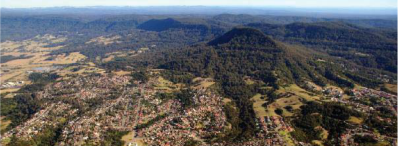
The Illawarra Escarpment is an iconic feature of the Illawarra region. It spans across public and private
tenures and has a complex history of use spanning tens of thousands of years; from Aboriginal occupation
through to a more recent history of agriculture, forestry, mining and residential use. Although in many
areas the escarpment appears as a somewhat homogenous green backdrop to Wollongong, the
escarpment is in fact a patchwork of pristine vegetation communities and more disturbed areas. The
escarpment has complex and enduring Indigenous and Non-Indigenous cultural heritage value. It is due to

Illawarra Escarpment Strategic Management Plan 2015 8|Page
the importance of this icon in the hearts of so many that its management must be considered with
appropriate care.
1.3 Vision
The IESMP 2015 is founded on the vision that the Illawarra Escarpment is an outstanding feature of the
Illawarra region providing a natural backdrop to the city as well as encompassing areas of high
conservation value and rich cultural heritage. The long term vision for this area is for these values to be
preserved and enhanced through public reserve or private stewardship.
1.4 EscarpmentValues
One of the objectives of the IESMP 2015 is to identify the environmental, cultural and economic values of
the escarpment and foothills requiring conservation. Through the Commission of Inquiry (1999) and the
development of the IESMP 2006, a broad range of values were identified as requiring preservation or
enhancement. Section 4 of this plan reviews these values in order to help guide improvement works on
the escarpment.
1.5 LandUsePlanning
One of the primary roles that Wollongong City Council fulfils in the management of the Illawarra
Escarpment is its land use planning function. Council has responsibility for developing the Wollongong
LEP, as well as assessing planning proposals and development applications within its local government
area. The Illawarra Escarpment is mapped in Wollongong LEP 2009 and is largely made up of
environmental zones E1 National Parks and Nature Reserves, E2 Environmental Conservation, E3
Environmental Management and E4 Environmental Living. A number of desired future outcomes have
been determined for these zones. Land use planning proposals in the escarpment will need to address
these desired future outcomes and a number of assessment criteria are presented in Section 5.5.4.
The IESMP 2006 mapped the Illawarra Escarpment based on its environmental attributes and which
identified areas as either Core Escarpment, Biophysical Support for Core, Landscape Support for Core and
Escarpment Interface.
Core Escarpment land as defined in the IESMP 2006 has the following values:
• all areas identified by DEC (2002) (bioregional assessment) as having primary conservation significance;
• all areas identified as having archaeological significance to European cultural heritage and identified as
being of state or regional heritage significance in the Wollongong LEP 1990 and the Illawarra REP (1986);
• 40m from the bank of all Category 1 streams identified by DIPNR (2004), plus a 10m buffer;
• all areas of escarpment face.
Biophysical Support for the Core Escarpment areas has the following values:
• all areas identified by DEC (2002) as being support for core areas,

Illawarra Escarpment Strategic Management Plan 2015 9|Page
• 20 m (at a minimum) from the ‘top of bank’ of Category 2 streams identified by DIPNR (2004) plus a 10
m buffer,
• all lands that have an unbroken boundary (ie. are surrounded) by Core Escarpment areas within the
study area.
Landscape Support for the Core Escarpment areas has the following values:
• all lands (at a minimum) within 10 m from the banks of Category 3 streams
identified by DIPNR (2004) plus a 10 m buffer,
• all lands identified as being within a floodway or flood prone area,
• all lands identified by DEC (2002) as being enhancement areas,
• all lands in the Illawarra escarpment unit having cultural landscape values identified in the 1981
Illawarra Regional Landscape and Environment Study at a level 5,
• all lands that have an unbroken boundary (that is are surrounded by) Biophysical Support areas within
the study area boundary.
Escarpment Interface areas have the following values:
• areas of prime crop and pasture lands identified in the Illawarra REP (1986),
• areas identified as not being suitable for urban expansion in the Illawarra REP or currently zoned for
urban use,
• land zoned 1 or 6a in the Wollongong LEP1990,
• land that is surrounded by landscape support within the study area boundary.
The IESMP 2006 proposed new zones for Wollongong LEP 1990 to reflect the values of these landscapes.
In 2006, the State government announced a standardised approach to the production of LEPs, where all
Councils in NSW would develop their local plans with common zoning definitions. This removed the ability
for the new zones, presented in IESMP 2006, to be implemented. Instead, the Illawarra Escarpment Land
Use Review Strategy 2007 applied the attribute mapping of IESMP 2006 to the Standard Instrument LEP
zones and recommended new zones consistent with the Standard Instrument. The Land Use Review
Strategy, along with public exhibition of the draft Wollongong LEP 2007 informed the development of
Wollongong LEP 2009, such that the attribute mapping conducted in 2006 was no longer required in the
IESMP 2015. Although the mapped escarpment attributes are not included in IESMP 2015, the
environmental attributes of the escarpment remain central to its strategic management. Any planning
proposals or Development Applications on the escarpment will need to undertake detailed mapping of
these values as a part of addressing the IESMP 2015.

Illawarra Escarpment Strategic Management Plan 2015 10 | Page
1.6 PressureStateResponseModel
The IESMP 2015 utilises a pressure state response model for managing the Illawarra Escarpment. This
model identifies the pressures or key threatening processes on an asset be it natural, cultural or
economic, then identifies the current state these assets are in and from these two elements a response is
determined to mitigate or minimise the threats to the asset.
A number of pressures have been identified as impacting on the escarpment, notably; mining, pest
animals, weeds, bush fire, land clearing/fragmentation, urban encroachment, high visual impact
development, agriculture, climate variability (weather extremes and seasonal variation) and unauthorised
access.
Measures of the state of the escarpment are limited by available technology and budget. Current data on
the state of the escarpment includes vegetation mapping, digital elevation and digital surface models,
visual quality assessments, landslip mapping and a heritage register.
The response element of the model occurs where Council’s normal operations impact on escarpment
management, such as in the case of Bush Fire management, and specifically with the range of actions
detailed in the Illawarra Escarpment Action Plan presented in Chapter 6.
1.7 IllawarraEscarpmentActionPlan
The action plan has been developed in order to assist Council to progress the objectives of the IESMP
2015 utilising available resources. The IESMP 2015 is considered a Supporting Document to Council’s
Integrated Planning and Reporting Framework. It is anticipated that the Action Plan will be utilised to
guide Council actions over the next five years and then be subject to review along with a future update to
the IESMP. Actions have been developed in three key themes:
• Community Capacity;
• Planning; and
• Governance.
The Community Capacity theme presents actions and strategies related to improving the level of
understanding and appreciation of the values of the Illawarra Escarpment. It is also recognised that
actions relevant to this theme may emerge from future landholder or general community proposals
presented to Council.
Community Capacity Objectives:
Increase understanding of escarpment values and management challenges.
Increase appreciation of the escarpment.
Develop skills and knowledge relevant to the ongoing management of the escarpment.
The Planning theme presents actions and strategies related to utilising the capacity of Council to
influence land use planning outcomes on the escarpment.

Illawarra Escarpment Strategic Management Plan 2015 11 | Page
Planning Objectives:
Improve Illawarra Escarpment land use planning.
Conserve Core Escarpment areas.
The Governance theme presents actions and strategies related to Council taking a leadership role in
preserving and enhancing the values of the Illawarra Escarpment. It includes actions related to improving
the evidence base for Council decisions on escarpment matters.
Governance Objectives:
Provide leadership on escarpment matters.
Develop the evidence base to help guide policy development and decision making.

Illawarra Escarpment Strategic Management Plan 2015 12 | Page
2Introduction
The Illawarra Escarpment is one of the most important landscape and cultural features of the Illawarra
region and has high aesthetic and environmental value to the Illawarra community. It has a deep and
complex cultural and spiritual significance for the Aboriginal community. Since 1788, the escarpment has
been viewed, chronologically as a constraint to be overcome, a resource to be exploited and an asset to
be preserved.
This plan was prepared by Wollongong City Council in consultation with the NSW Department of Planning
& Environment, National Parks & Wildlife Service, NSW Trade & Investment – Division of Resources &
Energy and the Escarpment Planning Reference Group; comprising Councillors, landholders, community
members, community group representatives and local Aboriginal representatives.
The plan is an updated version of the Illawarra Escarpment Strategic Management Plan 2006 (IESMP
2006) and has been informed by a number of studies which include:
Commission of Inquiry into the Long Term Planning and Management of the Illawarra Escarpment
(Simpson, 1999)
Bioregional Assessment (flora and fauna) Parts 1–3 (NSW National Parks and Wildlife Service,
2002b);
Riparian (Creek) Corridor Management Study (DIPNR, 2004);
Landslip maps – University of Wollongong and Wollongong City Council (Flentje, 2007);
Strategic Weed Management Plan (BES, 2006);
Strategic Management Plan for Historic Coal Mining Sites of the Illawarra (OHM Consultants,
2006);
Illawarra Escarpment Heritage Assessment (Mayne-Wilson and Associates and Meredith Walker
Heritage Futures, in association with Godden Mackay Logan Pty Ltd, 2007);
Illawarra Escarpment Land Use Review Strategy (HLA-Envirosciences, 2007);
Aboriginal Heritage Study: Illawarra Escarpment (Australian Museum Business Services, 2008);
Illawarra Biodiversity Strategy (Wollongong City Council, 2011);
Illawarra Regional Food Strategy (Wollongong City Council, 2013); and
Farmborough Heights to Mount Kembla Strategic Planning Study (GHD, 2013).
It also refers to studies that directly affect the planning and management of the escarpment, these
include:

Illawarra Escarpment Strategic Management Plan 2015 13 | Page
Illawarra Escarpment State Conservation Area: draft Plan of Management (NSW National Parks
and Wildlife Service, 2011)
Bush Fire Risk Management Plan (Illawarra Bush Fire Management Committee, 2008); and
Bushfire Asset Protection Zone Risk Management Study (BES, 2006).
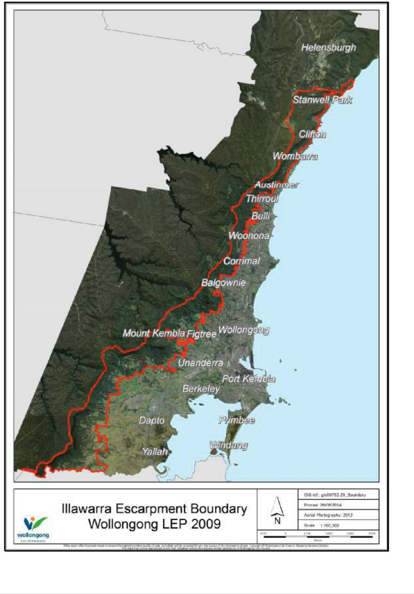
2.1 IllawarraEscarpmentBoundary
The Illawarra Escarpment forms a natural boundary and scenic backdrop to the Wollongong coastal plain.
Although the landform extends south beyond the boundary of Wollongong Local Government Area (LGA),
this management plan is limited to the Wollongong LGA.
It is difficult to define a boundary for the Illawarra Escarpment due to the variety of landscape features
that comprise the Illawarra Escarpment. The existence of residential development such as Mount Kembla
village in areas with escarpment landform characteristics further complicates the process. In particular, in
the north of the Wollongong LGA there is typically a steep transition from the escarpment and the coastal
plain, whereas the south has significant areas of rolling foothills comprising elevated benches of relatively
flat land. No single elevation represents where the coastal plain ends and the escarpment begins. The
boundary of the Illawarra Escarpment has been defined differently in:
The Illawarra Regional Environmental Plan (1986);
Commission of Inquiry into the Illawarra Escarpment and Coastal Plain (1999);
Illawarra Escarpment Strategic Management Plan (2006); and
Wollongong Local Environment Plan 2009.
For administrative purposes and to provide clarity, the most recent definition from the Wollongong LEP
2009 is used in this document. A map of the Illawarra Escarpment Study area is provided in Figure 1.1. As
discussed further in this document, escarpment values and considerations often extend beyond this
boundary, however, the Wollongong LEP 2009 boundary is the trigger used for consideration of Illawarra
Escarpment issues in land use planning proposals.
Illawarra Escarpment Strategic Management Plan 2015 14 | Page
Figure 1.1 Illawarra Escarpment Boundary as defined in Wollongong Local Environment Plan 2009.

Illawarra Escarpment Strategic Management Plan 2015 15 | Page
2.2 HistoryoftheIllawarraEscarpment
2.2.1 AboriginalHistory
The Aboriginal world view of the Dreaming differs from the linear historical perspective of Non-
Indigenous history. Traditional Aboriginal people view the land as an intrinsic part of their existence. As
such, the Illawarra Escarpment is not simply a landmark or area to shelter in or traverse, but an integral
part of their reality.
The Illawarra Escarpment is central to numerous dreaming stories that integrate the lores, customs and
protocols to which the Aboriginal peoples encompassed by the escarpment adhere. “Warra Bingi Nunda
Gurri” is the escarpment Dreaming. It includes all living things; it is as much about Aboriginal people as it
is about the plants, bird and animals of the escarpment. It embraces the seasons, spirituality and
teachings of Aboriginal culture. It is central to Aboriginal belonging.
Aboriginal people have occupied the Illawarra for at least 20,000 years. The Illawarra was well populated
before European contact due to the abundant natural resources of the escarpment and coastal plain. The
escarpment contains many important Aboriginal cultural sites associated with ceremonial practices and
gathering food and medicine (NPWS, 2003). Many of these are not yet documented (Australian Museum
Business Services, 2008).
The traditional Aboriginal clans of the Illawarra belonged to the Dharawal language group (Organ, 1997).
The settlement of the Illawarra, initially by escaped convicts, then through government land grants,
substantially displaced local Aboriginals from utilising the escarpment and coastal plain. Corroborees
were held in the area up until 1870. The escarpment provided opportunities for Aboriginal occupation
into the 20
th
century due to its steepness and vegetation making it unsuitable for cultivation by the
colonisers (Kass, 2010).
2.2.2 RecentHistory
Following European settlement, the escarpment has not always been so heavily vegetated. Many early
paintings and photographs of the escarpment show a region full of ringbarked trees and cleared
vegetation as mining and forestry harvested much of the vegetation (Figure 1.2). Therefore, a large
portion of the escarpment is in a state of regeneration from these extractive practices.
Mining and agricultural activities continue within the escarpment today. In recent years, the escarpment
has increasingly been under pressure for housing development. Although the Illawarra Escarpment is not
seen as an area suitable for urban release like the coastal plain, it remains highly attractive for residential
development. Once escarpment land is developed for housing, its potential to contribute to broader
cultural, environmental or scenic values is either removed or diminished. There is strong community
pressure on Council for there to be no further development of the escarpment for housing.
The community, various non-government organisations as well as a range of government agencies, have
all expressed concern for the preservation and conservation (of the natural and cultural resources) of the
escarpment over many years. The escarpment is a collective asset that must be planned for and
conserved by collective effort and commitment.

Illawarra Escarpment Strategic Management Plan 2015 16 | Page
The escarpment has ongoing cultural significance for the Illawarra Aboriginal community. Conservation of
escarpment land is of central importance to maintaining local Aboriginal cultural heritage.
Community concern for conservation of the escarpment arose alongside the development of
environmental awareness from the 1960s. More intensive involvement emerged with the establishment
of the Illawarra Escarpment Working Party (IEWP) in October 1990. The IEWP operated under the
leadership of Wollongong City Council with various members from 1990 to 1997.
Part of the role of the Illawarra Escarpment Working Party was to comment on rezoning proposals in the
Illawarra Escarpment. Examples of inappropriate development on the escarpment increased until
submissions regarding concern for the management and planning of the escarpment were made to the
NSW Minister for Urban Affairs and Planning on behalf of Wollongong City Council, as well as many
residents. These prompted the Minister to announce a ‘Commission of Inquiry into the Long Term
Planning and Management of the Illawarra Escarpment and Coastal Plain’. The Commission of Inquiry
(COI) began conducting hearings on 7 December 1998 and the final report was completed in May 1999.
In December 2000, the NSW Government announced its broad endorsement for implementing the
recommendations of the COI into ‘The Long Term Planning and Management of the Illawarra Escarpment’
(see section 3.1). Following the COI, a number of studies were undertaken and a public consultation
process guided the development of the Illawarra Escarpment Strategic Management Plan which was
endorsed by Council in 2005 and the NSW Minister for Planning in May 2006.
Figure 1.2 Moore St Austinmer showing ring barked trees

Illawarra Escarpment Strategic Management Plan 2015 17 | Page
2.3 Vision
This management plan is founded on the following vision for the escarpment:
The Illawarra Escarpment is an outstanding feature of the Illawarra region providing a natural backdrop
to the city as well as encompassing areas of high conservation value and rich cultural heritage. The long
term vision for this area is for these values to be preserved and enhanced through public reserve or
private stewardship.
2.4 Objectives
Theobjectivesof theIESMP2015areto:
1. identify the environmental, cultural and economic values of the escarpment and foothills
requiring conservation;
2. define the principles and strategic direction for protecting and enhancing escarpment values.
3. outline an action plan for Council to improve escarpment management.
2.5 Principles
The IESMP 2015 is based on a number of guiding principles that include:
the Aboriginal people are the original custodians of the environment;
the escarpment has important natural and cultural heritage values which need to be preserved;
some areas of the escarpment are in a degraded state and therefore require active management;
any development of the escarpment should result in an overall conservation improvement to the
escarpment;
private stewardship of escarpment land is required to protect and enhance escarpment values;
partnerships between land managers and government is required to improve the condition of the
escarpment;
all sectors of the community need to be engaged in asset management;
an adaptive management approach is required to ensure actions are effective;
the escarpment must be considered as a whole to avoid multiple small decisions leading to
negative cumulative impacts;
a long term strategic approach should be adopted; and
Ecologically Sustainable Development principles should be applied in managing the assets of the
escarpment*.

Illawarra Escarpment Strategic Management Plan 2015 18 | Page
*Ecological Sustainable Development (ESD) is defined by the National Strategy for ESD as:
Development that improves the total quality of life, both now and in the future, in a way that
maintains ecological processes on which life depends.
The ESD principles articulated for local governments, that underpin the definition of ESD include:
Precautionary principle – whereby lack of scientific certainty doesn’t prevent you taking
mitigating measures to prevent impact;
Intra and inter-generational equity – fairness and equal access to opportunities both in our
lifetimes and for future generations;
Environmental valuation – placing a value on the environmental resource;
Ecological integrity – protecting biological diversity and maintaining essential ecological processes
and life support systems;
Community consultation – the community should be consulted about the ecological, social and
economic considerations in decision making;
Continual improvement – there is an imperative to take immediate action to become more
sustainable; and
Integration – the effective integration of environmental, social and economic considerations in
decision making.
Many of these principles have been recurring themes throughout the Commission of Inquiry as well as
the various consultative forums. Commissioner Simpson discussed the precautionary principle a number
of times throughout his report and stressed the need to determine management options and priorities
according to this principle.
2.6 RoleofCouncil
Council has limited direct control of outcomes on the Illawarra Escarpment due to its minor status as a
land owner on the escarpment and the limitations of its legislative power. The primary managers of
escarpment land are the National Parks and Wildlife Service (approximately 29% of the escarpment), and
the many private landholders (approximately 60% of the escarpment).
The influence of Council on the Illawarra Escarpment is confined to its role in developing and
implementing local planning controls and working with land managers within the escarpment as well as
the broader community. The limited ability of Council to directly affect escarpment management is an
underlying assumption in the preparation of this plan.
Although Council is limited in its ability to directly control outcomes on the Illawarra Escarpment, the
content of this plan provide the basis for Council, land managers and the community to work in
partnership to maintain and improve the escarpment as a natural backdrop to the city, as well as
encompassing areas of high conservation value and rich cultural heritage.

Illawarra Escarpment Strategic Management Plan 2015 19 | Page
3Background
3.1 CommissionofInquiry(1999)
The Commission of Inquiry (COI) into the Long Term Planning and Management of the Illawarra
Escarpment was announced by the then Minister for Urban Affairs and Planning on 19 October 1998. The
terms of reference for the COI required the Commissioner to formulate and recommend appropriate and
long term land use planning, development control and land management measures to protect and
conserve the environment of the escarpment. Ancillary to this, the Commissioner was required to
recommend criteria for identifying land to form “core” and “non core” escarpment areas and to
recommend the appropriate ownership and management arrangements for such land.
Commissioner Simpson conducted the COI during December 1998 and January 1999. 118 parties made
written submissions to the inquiry, 58 parties made oral submissions in the primary sessions and 19
parties appeared in the submission in reply session.
In May 1999, the Commissioner released his written report. The report made 22 recommendations on
broad strategic planning, policy and environmental management issues. It also commented on specific
land use change and development proposals (see a précis of the COI recommendations in section 3.1.1).
The findings were critical of past approaches to planning and landuse management of the escarpment
and fringe escarpment land. The criticism was principally aimed at a lack of comprehensive constraints
mapping to underpin the Fair Trading Policy (FTP) and Rural Residential Policy (RRP). While these policies
recognised the need for, and indeed required rigorous constraints investigation with each proposal, the
COI found that these investigations should have occurred as part of the preparation of the policy rather
than on a site-by-site basis as had been the case.
The major recommendations of the COI were aimed at redressing this lack of baseline constraint
mapping. The Commissioner supported the fair trading concept as a means of acquiring environmentally
significant land. Protection and conservation of the escarpment through acquisition into public
ownership was seen by the Commissioner as a preferred option for future management. Both the
Commissioner in his report and the Minister in his announcement in support of the COI identified as a
priority, the creation of a regional park under the National Parks and Wildlife Act, 1974. However, neither
the Minister nor Commissioner addressed the issue of how the acquisition of this area would be
achieved. The issue of transition of escarpment land into public ownership remains a challenge, and is
considered further in this report.
3.1.1 CommissionofInquiryFindings
The Commissioner concluded that the management, planning, conservation and protection of the
escarpment should be as a single entity. It was concluded that the escarpment must be considered in a
total catchment management framework (including riparian land function, downstream hydrology and
flooding on the coastal plain). Similar planning principles should apply to the ecology, visual and heritage
significance. Simplistically, the visual backdrop of the escarpment requires the preservation of the tree
line in both the core and non–core escarpment land. The Commissioner’s findings detailed below

Illawarra Escarpment Strategic Management Plan 2015 20 | Page
contend that development must not be allowed to dominate the escarpment and that habitat and
biodiversity considerations are not limited or restricted to zoning boundaries.
The implementation of the Fair Trading Policy, despite the objectives of the zonings under the
Local Environment Plan, has resulted in increased intensity of development in environmentally
zoned 7(b) land.
The Rural Residential Policy and Fair Trading Policy are not explicit in providing an adequate guide
to the extent of development to emerge from these policies.
Wollongong City Council (WCC) has placed too much emphasis on conservation and securing of
Core Escarpment 7(a) lands into public ownership to the detriment (environmental and
conservation) of the environmentally zoned 7(b) land.
There has been a lack of ecological appraisal for the environmental capacity of environmentally
zoned 7(b) lands to accommodate the likely level of development as a result of the Fair Trading
Policy (FTP). Similarly, inadequate consideration has been given to the cumulative impact of
development in the environmentally zoned 7(b) land.
Consideration of upstream/downstream impacts of rezoning proposals has not occurred,
particularly as it relates to past mining activities, catchment management principles and coal
waste deposits and land stability.
The decision making of some rezoning lacked any understanding of ecological/biological
principles and the inter-relationship between Core Escarpment 7(a) and environmentally zoned
7(b) land, the escarpment and coastal plain.
There has been inadequate consultation with relevant State Government departments and the
community at initial stages of rezoning applications.
The State and Regional significance of the escarpment needs to be determined so a proper
assessment can be made of development impacts at the local and regional level.
The outcome of the constraint mapping studies may suggest that the majority of the escarpment
is unsuitable or incapable of further rural or residential development.
The present approach to environmental planning and management of the escarpment is
inadequate.
More detailed provisions are required in the Illawarra Regional Environmental Plan 1986
concerning management and conservation of the escarpment that should be directly related to
the principles of ESD.
3.2 IllawarraEscarpmentStrategicManagementPlan2006
Following the COI, a whole of government Project Coordination Team (PCT) comprising state government
agenciesandCouncilwasestablishedin2001.ThePCTwasledbythethenDepartmentofInfrastructure
Planning and Natural Resources. In order to engage the broader community, an Illawarra Escarpment

Illawarra Escarpment Strategic Management Plan 2015 21 | Page
Community Reference Group (IECRG) was established in October 2002. The IECRG reviewed the draft
IESMP between 9 August 2003 and 5 November 2003. The IECRG feedback reflected frustration that the
group had insufficient time to discuss the range of issues involved in the draft IESMP. The process of
developing the draft IESMP involved:
multiple meetings of the IECRG to discuss aspects of the draft plan;
three workshops conducted by CSIRO as part of the Social Study, these workshops focussed on
community perceptions of proposed land use changes;
consultation occurred with over 100 (mostly landholders) to inform the commission studies and
develop the framework for the draft plan.
The draft Illawarra Escarpment Strategic Management Plan was publically exhibited between February
and May 2004.
In response to the exhibition, 278 submissions were received on the draft IESMP, including a range of
views. Many submissions also suggested improvements to the Plan and requests for special consideration
with regard to certain properties.
Review of the submissions revealed a number of key issues that were consistently raised regarding:
The need for more funding for the escarpment;
The likely negative effect of the IESMP on escarpment land values;
The inequity of proposed zonings on land not developed prior to the Commission of Inquiry;
Confusion over existing use rights;
The need for financial compensation for landowners in the escarpment;
Criticism of the Tradeable Development Rights concept;
Inadequate time to consider the draft IESMP;
Inadequate consideration of bushfire management;
Incorrect mapping of escarpment values and boundary;
Objection to the concept of an Escarpment Regional Park – public ownership will lead to neglect;
and
Not all of the COI recommendations were addressed by the IESMP.
In May 2005, Council endorsed the Illawarra Escarpment Strategic Management Plan to be submitted to
the NSW Minister for Planning. The Minister endorsed the amended Illawarra Escarpment Strategic
Management Plan in May 2006.
Notable changes made between the Council endorsed draft and the adopted IESMP 2006 were:
Illawarra Escarpment Strategic Management Plan 2015 22 | Page
Management Structure – to be a committee of Council rather than a separate State Authority;
Where the IESMP overlaps the West Dapto Structure Plan, the West Dapto Structure Plan takes
precedence; and
The proposed Entitlement Transfer Scheme be removed from the IESMP.
3.2.1 ManagementStructure
The IESMP 2006 called for a Committee of Wollongong Council to manage the implementation of the
plan. The Escarpment Planning Reference Group was established by Council at its 26 March 2012
meeting. The reference group is made up of three Councillors, representatives of community groups,
individual community representatives, landholder representatives and Aboriginal representatives. The
reference group is supported by agency advisors from the NSW Department of Planning and
Environment, the Office of Environment and Heritage, Local Land Services and the National Parks and
Wildlife Service. The group meet bi-monthly to progress the implementation of the actions within IESMP
2006 and comment on relevant rezoning proposals. In 2014, the group has focussed on reviewing and
updating the IESMP. The group will continue to meet on an as needs basis.
3.2.2 Management–InvestigationandPlanningPhase
The management measures proposed by the IESMP 2006 were summarised as key actions in two phases.
The first phase was the investigation and planning phase. This consisted of studies to inform the
management of the Illawarra Escarpment and contribute further information to the revision of land use
zoning. The second phase consisted of on-ground works programs arising from the recommendations of
the studies. In some cases, the actions identified within the IESMP 2006 mirrored actions and/or
initiatives which had already been identified in other plans or which were required by legislation/agency
guidelines.
Several major studies were conducted as part of the Investigation and Planning Phase of the IESMP 2006:
Land Use Review Strategy (HLA-Envirosciences, 2007);
Aboriginal Heritage Study (Australian Museum Business Services, 2008);
Non-Indigenous Heritage Assessment (Mayne-Wilson and Associates and Meredith Walker
Heritage Futures, in association with Godden Mackay Logan Pty Ltd, 2007);
Strategic Weed Management Plan (BES, 2006);
Visual Quality Analysis (DSB Landscape Architects, 2006); and
Riparian Corridor Policy Study (HLA-Envirosciences, 2006).
Actions identified within the Investigation and Planning Phase of the IESMP 2006 are described in
Appendix C. This is to provide a snapshot of their status at the time of the preparation of this updated
plan.
3.2.3 Management–On-groundWorks
The on-ground works programs proposed by the IESMP 2006 are generally components of broader
Council management programs. Biodiversity, weed, riparian corridor, erosion, feral animal control,
heritage, bush fire, and asset management are all considered as part of Wollongong-wide Council

Illawarra Escarpment Strategic Management Plan 2015 23 | Page
programs. The level of on-ground works occurring in the Illawarra Escarpment is limited by the small
proportion of Council land located within the escarpment (approximately 5% of the escarpment study
area) and current operational budgets. Progress on the on-ground works phase is summarised in
Appendix D.
3.3 IllawarraEscarpmentLandUseReviewStrategy(2007)
Following the endorsement of the IESMP in May 2006, Wollongong City Council commissioned the
preparation of the Illawarra Escarpment Land Use Review Strategy (IELURS). The IELURS was completed
and endorsed by Council in August 2007.
The initial draft Wollongong LEP translated Wollongong LEP 1990 zones into their most appropriate
standard template zone. The IELURS reviewed these planning controls in the escarpment against the
objectives and attributes mapping of the IESMP 2006. It recommended zonings and additional clauses to
be exhibited as part of Draft Wollongong LEP 2007 and Draft West Dapto LEP 2006.
The IELURS reviewed the entire IESMP 2006 study area. For areas where extensive areas were mapped as
Core Escarpment or Biophysical Support for Core Escarpment, environmental zones were recommended
in favour of Rural Zones. The IELURS also developed additional analysis of the scenic and visual character
of the Illawarra Escarpment through a Visual Quality Analysis and provided additional information on
subjects such as bush fire management and built form to support the development of Wollongong
Development Control Plan (DCP) 2010 Chapter B6 Development in the Illawarra Escarpment.
The IELURS took into account the Strategic Weed Management Plan for the Illawarra Escarpment 2006,
and was undertaken concurrently with the Illawarra Escarpment Heritage Assessment Part II 2007 and the
Aboriginal Heritage Study 2008.
3.4 WollongongLocalEnvironmentPlan2009
The draft Wollongong LEP was exhibited between December 2008 and April 2009. The draft LEP included
zones recommended by the IELURS which was a supporting document to the exhibition. In consideration
of issues raised in submissions, Council revised some zonings and zone boundaries in the escarpment
from those recommended by the IELURS. The Wollongong LEP 2009 was endorsed by Council on 28 July
2009 and approved by the Minister for Planning on 26 February 2010.
3.5 FarmboroughHeightstoMountKemblaConceptPlan
In adopting the Illawarra Escarpment Land Use Review Strategy in 2007, Council resolved that the
Farmborough Heights to Mount Kembla precinct required a Master Plan to guide future zoning. In 2011,
the Department of Planning recognised the potential for appropriately scaled and located development in
the study area. Council resolved in 2012 to engage consultants to develop a Concept Plan for the area. In
December 2013 the Plan was endorsed by Council following public exhibition. The Department of
Planning endorsed the Plan in March 2014.
The Farmborough Heights to Mount Kembla Concept Plan was accompanied by a set of planning
principles consistent with the Illawarra Escarpment Strategic Management Plan. Following the exhibition
of the draft Plan, additional principles were endorsed by Council.

Illawarra Escarpment Strategic Management Plan 2015 24 | Page
The provision of limited residential development must be considered within the context of active
conservation and as a secondary outcome (COI);
Planning proposals must provide justification in terms of specific conservation initiatives
proposed to enhance the escarpment for the long term; and
A corridor of rural and bushland around the eastern approaches to Mt Kembla must be
maintained to provide a separation from Cordeaux Heights and to preserve the historic identity of
Mt Kembla Village.
Individuals within the study area are responsible for submitting planning proposals to Council. However,
these will be considered with regards to the Concept Plan and must demonstrate mechanisms by which
the rezoning will lead to an overall conservation improvement for the escarpment or foothills.
3.6 Ownership
The Illawarra Escarpment, as defined in this plan, contains approximately 2000 parcels of land in
approximately 1300 separate ownerships. The majority of the area is in private ownership, with 40.5% in
public ownership.
National Parks and Wildlife Service account for almost 29% of the escarpment area, with all other public
land owners combined making up the remaining 11%.
Table 2. Escarpment ownership.
Public Area Ha. Proportion
Private 5732.8 59.5%
National Parks and Wildlife Service 2784.6 28.9%
Wollongong City Council 446.2 4.6%
Water NSW 379.8 3.9%
Roads and Maritime Services 123.7 1.3%
Sydney Water Corporation 59.7 0.6%
State Rail Authority of NSW 45.9 0.5%
Rail Corp 43.8 0.5%
Land and Property Management Authority 20.2 0.2%
Department of Education 0.6 0.0%
TOTAL 9637.3

Illawarra Escarpment Strategic Management Plan 2015 25 | Page
3.6.1 Mining
Mining companies are significant landholders in the escarpment due to the long and ongoing history of
coal mining in the escarpment. There are currently three active mines within the study area. In the
financial year 2012–13, approximately 5,824,337 tonnes of coal was extracted from these mines.
Wongawilli Colliery – 496,851 tonnes Run of Mine coal
Russell Vale Colliery – 784,733 tonnes Run of Mine coal
Dendrobium Colliery – 4,542,753 tonnes Run of Mine coal
The Illawarra Escarpment State Conservation Area (IESCA) was established in 1980 following an initial
donation of land from Australian Iron and Steel Pty Ltd (now BHP Billiton). Mines that are no longer active
and have been rehabilitated are sometimes suitable for redevelopment. Since 2006, mine redevelopment
options in the escarpment have been considered in light of the objectives of the IESMP 2006.
A summary of the current status of mines within the study area is presented in Appendix A.
Mining has brought economic benefits to the Wollongong LGA. Mining companies currently contribute
towards the active management of the Illawarra Escarpment through weed, bush fire and pest
management. The Illawarra Escarpment State Conservation Area has also been established above mine
sites, where the surface is managed by the NPWS, but the underlying resources are owned by the coal
companies.
Current mining activity is largely regulated by the state government. Mining activities are monitored and
reviewed by the Illawarra Coal Mine Interagency Group, made up of representatives from the
Department of Trade & Investment, National Parks and Wildlife Service, Environmental Protection
Agency, Water NSW, Office of Environment and Heritage and Wollongong City Council. The group review
Mining Operations Plans and Annual Environmental Management Reports submitted by active mine
operations. Current mining operations are regulated to ensure that activities do not lead to significant
environmental impacts.
3.6.2 Farmland
Wollongong has a proud history of agriculture, with a particularly advanced dairy farming industry
existing for much of the 20
th
Century. With increased planned urban development in West Dapto, and
economic restructuring of the dairy sector, agricultural land use has progressively declined in
Wollongong.
Under Council’s Fair Trade and Rural Residential Policies, some landowners subdivided their land as a
means of transitioning from agricultural or rural use to residential use, in some cases, dedicating parcels
of land to Council to contribute to a future escarpment reserve. These policies were repealed following
the recommendations of the COI 1999, and Council has not re-instated these policies.
Following the repeal of the Fair Trade and Rural Residential Policies, some residents have expressed
frustration at no longer having a clear policy framework for developing former farmland for residential
purposes (West Dapto Rural Ratepayers Association, 2003).

Illawarra Escarpment Strategic Management Plan 2015 26 | Page
In the south of the Wollongong LGA, the landform of the escarpment is less steep than the northern
areas. Within this environment of hills and valleys between the coastal plain and the steep escarpment,
agricultural activities have historically been pursued. The nature of the landform in this area has made
land use planning more difficult and it has been considered as part of both the West Dapto Urban Release
Area and Illawarra Escarpment planning processes. As the rezoning and development of West Dapto
progresses, the interface between the escarpment and West Dapto will need to be carefully managed.
There is growing evidence of the importance of local food production for food security and health. In
many instances across the world and even as close as the south coast of NSW, food is being produced on
relatively small lots in proximity to local markets. The potential for small scale, diversified, regenerative
food production to form a part of the future management of the escarpment foothills has not been
closely examined as yet.
3.6.3 DedicationofLandtoPublicOwnership
The conservation of the Illawarra Escarpment in a continuous reserve has been mooted since 1971
(Natural Heritage Society Report). A primary motivation for the Fair Trading Policy was the transfer of
core escarpment land into public ownership. This theme was again reflected in the COI 1999 which called
for core escarpment land to be dedicated to the creation of a National Park.
The history of land dedication is complex, with the Illawarra State Conservation Area retaining the rights
for underground mining. The current extent of National Parks managed reserve in the Wollongong Local
Government Area is shown in Figure 2. Also, some parcels of land dedicated under the now defunct Fair
Trade Policy were not accepted as part of the reserve system by NPWS due to their condition or isolation
from the broader reserve. These parcels are retained in Council ownership with a view to future
integration into National Parks Reserve.
Although an increase in the continuity and extent of the Illawarra Escarpment State Conservation Area is
desirable to aid the conservation and management of high conservation land, Council cannot dictate this
process. Dedication of land to National Parks reserve is considered by NPWS on a case-by-case basis. All
proposals for dedication of land to append the Illawarra State Conservation Area are reviewed by the
Office of Environment and Heritage.

Illawarra Escarpment Strategic Management Plan 2015 27 | Page
Figure 3.1. Map of the Illawarra Area National Parks managed reserve and Council land relative to the
Illawarra Escarpment boundary and the Wollongong Local Government Area.

Illawarra Escarpment Strategic Management Plan 2015 28 | Page
3.6.4 Stewardship
In 2006, the Illawarra Escarpment Strategic Management Plan (IESMP 2006) acknowledged that a broader
concept of an escarpment ‘park’ must be considered where dedication to reserve was not the only means
of conserving the escarpment. It suggested voluntary conservation agreements and a range of financial
and non-financial incentives could be used to encourage management consistent with the principles
applied to managing National Parks reserves.
Since the endorsement of the IESMP in 2006, Council has focussed primarily on the development of Local
Environment Plan zones on the Illawarra Escarpment. The long term process of Council working with
landowners to support and encourage conservation activities on the escarpment outside of normal
planning functions is yet to occur. This updated IESMP 2015 endeavours to develop this capacity through
actions detailed in Chapter 6.

Illawarra Escarpment Strategic Management Plan 2015 29 | Page
4EscarpmentValues
One of the primary objectives of the IESMP 2015 is to identify the environmental, cultural and economic
values of the escarpment and foothills requiring conservation. Through the COI and the IESMP 2006, a
broad range of values have been identified as requiring preservation. This section reviews the range of
values to be considered in escarpment management. Over time, and with increased knowledge of the
escarpment, these values will be further refined and measured.
4.1 Environmenta lValues
4.1.1 Biodiversity
TheIllawarraEscarpmentissituatedwithintheSydneyBioregionwhichextendsfromNewcastleinthe
north, to Batemans Bay in the south (NSW National Parks and Wildlife Service, 2002a). Many plants
within the escarpment are at the limits of their northern or southern extent leading to a high biodiversity
as these subregional communities overlap. The escarpment is unique within this bioregion due to its
dramatic form, climate and geology. With high rainfall, fertile soil and warm temperatures, it supports
many vegetation communities restricted to the Illawarra region, in particular, extensive rainforests (NSW
National Parks and Wildlife Service, 2002a).
Biodiversity Values to be Preserved or Enhanced
Natural ecosystem function;
Connectivity – moist forest escarpment linkage, Yallah Calderwood linkage, plateau forest
woodland/heathland linkage;
Vegetated buffers – high conservation value ecosystems require vegetated buffers to reduce
edge effects;
Healthy systems to support food production;
High air quality associated with ecosystem services;
Genetic diversity for resilience to climate change;
Carbon sequestering; and
Rare and endangered species, communities, habitats and populations.
4.1.2 Water
There is very little documented evidence of the location of groundwater and aquifers within the Illawarra
Escarpment. Despite this lack of detail, underground water supplies are likely to be integral to the survival
of sensitive vegetation communities such as rainforests and above the escarpment, swamplands. Also,
activities within the escarpment such as mining and agriculture are likely to be modifying downstream
water quality and quantity.

Illawarra Escarpment Strategic Management Plan 2015 30 | Page
In particular, current and past mining activities are likely to be modifying groundwater and surface water
quality and quantity. Contamination/pollution of surface water such as creeks and streams from domestic
and other human presence, mine tailings and disposal, particularly where they have entered streams
following mining operations are all processes that can negatively affect water values.
Streams and creeks are important features linking the escarpment to the coastal plain and ocean.
Management of water quality and quantity is important for maintaining the health of these waterways
and their receiving systems.
Improved knowledge of water values and processes affecting water such as the location of water storage
areas, source pollutants and stream modifications is required to guide management options.
Water Related Values to be Preserved or Enhanced
Natural ecosystem function;
Water quality – for human use or ecological function;
Reduction of bed and bank erosion;
Reduced risk of flooding;
Enhancement of riparian vegetation and reliant ecosystems;
Natural water supply to dependent ecosystems; and
Visual quality – waterfalls, streams and pools, cultural heritage.
4.2 Culturalvalues
The physical prominence of the escarpment has profoundly influenced the history of the Wollongong LGA
and continues to be an integral part of the City’s sense of place (Mayne-Wilson and Associates and
Meredith Walker Heritage Futures, in association with Godden Mackay Logan Pty Ltd, 2007). It has
historical, present and future cultural value to the city as well as being an important repository of natural
and cultural heritage. The relationship between people and the escarpment is highly complex (Macquarie,
2013). For the purposes of this plan, several key areas of cultural value are highlighted and discussed.
4.2.1 ScenicValue
There has been no formal comparison of the Illawarra Escarpment with other places. However, there are
strong parallels between the escarpment, its history of use, proximity of urban development and public
appreciation and the foreshore of Sydney Harbour and parts of the Blue Mountains (Mayne-Wilson and
Associates and Meredith Walker Heritage Futures, in association with Godden Mackay Logan Pty Ltd,
2003). Similar to Sydney Harbour and the Blue Mountains, the escarpment has strong cultural and
natural heritage value.
The visual quality of the escarpment is generally regarded as exceptional or very high (HLA-
Envirosciences, 2007). A Visual Quality Analysis of Escarpment Scenic Values undertaken on behalf of

Illawarra Escarpment Strategic Management Plan 2015 31 | Page
Council in 2006 identified several precincts of distinctive character with varying levels of visual value
(Figure 4.1).
Figure 4.1. Map of visual precincts defined by the Visual Quality Assessment 2006.

Illawarra Escarpment Strategic Management Plan 2015 32 | Page
Table 3. The visual value of ten precincts within the escarpment study area. Landform scarcity refers to
whether the landform is unique (H), repetitive (M) or common (L). Vegetation significance refers to the
aesthetic importance and integrity of the precinct and the built environment features measure the
degree to which the built form adds or subtracts from these aesthetic values.
Precinct Landform Scarcity
Vegetation
Significance
Built Environment
Features
Marshall Mount H H M
–
H
West Dapto Bowl M
–
HH L
–
M
The Heights L L L
Mount Kembla M
–
HH M
–
H
Mount Keira H H H
Balgownie H H M
–
L
Coastal Ridges M H M
Cliff Coast H H M
–
H
Stanwell H H M
–
H
Maddens Plains H H M
–
L
From this precinct based analysis it is evident that visual values vary amongst sub-sections of the
escarpment. This must be kept in mind when assessing the relative impact of proposals on scenic value.
These issues are discussed in more detail within the visual assessment report (DSB Landscape Architects,
2006).
Scenic Values to be Preserved or Enhanced
Escarpment as a vegetated backdrop to Wollongong coastal plain;
Escarpment ridges, spurs, valleys and creeks;
Scenic rural interface between the vegetated escarpment and urban development; and
Opportunity for dramatic lookouts over the coastal plain.
4.2.2 AboriginalHeritageValue
The Aboriginal Heritage Study completed for Council in 2008 identified that the Illawarra Escarpment
contains places of cultural heritage significance to the local Aboriginal community, as well as Aboriginal
cultural heritage sites of all degrees of archaeological and cultural significance (Australian Museum
Business Services, 2008). The study highlighted that due to the inaccessibility of many areas of the

Illawarra Escarpment Strategic Management Plan 2015 33 | Page
escarpment, a large number of Aboriginal cultural heritage sites are likely to exist, but are not as yet
recorded. The study also pointed to the fact that Aboriginal heritage extends beyond physical evidence of
occupation.
Consistent with the Office of Environment and Heritage Aboriginal Heritage Guidelines, there are two
types of Aboriginal significance: social significance and archaeological significance (Office of Environment
and Heritage, 2011). Social significance refers to the importance of a site or feature to the local Aboriginal
community, whereas archaeological significance refers to the importance of a site or object to the
understanding of previous human behaviour.
The Aboriginal Heritage Study 2008 identified the Wodi Wodi track leading from the escarpment to
Sandon Point in Bulli as being of particular cultural importance to local Aboriginals (Australian Museum
Business Services, 2008). The lower section of this track is generally known as the Throsby track.
The archaeological significance of sites within the Illawarra Escarpment can only be determined by
individual assessment. It should be noted, however, that the high levels of historical disturbance
associated with forestry, agriculture and mining mean any remaining archaeological sites are likely to be
significant.
Central to the management recommendations of the report is the need to include consultation with the
local Aboriginal community in escarpment matters, from strategic planning through to on-ground works.
Aboriginal Heritage Values to be Preserved or Enhanced
Sites of social significance;
Escarpment ridges, spurs, valleys and creeks;
Evidence of previous Aboriginal occupation; and
Local cultural knowledge and connection with the escarpment.
4.2.3 Non-IndigenousHeritageValue
The Heritage Study completed for Council in 2007 identified the escarpment’s high natural values and
exceptional scenic qualities which provide a most distinctive sense of place and provides a unifying
feature and symbol of the Illawarra region (Mayne-Wilson and Associates and Meredith Walker Heritage
Futures, in association with Godden Mackay Logan Pty Ltd, 2007). Most importantly, the study recognises
that the escarpment is a ‘cultural landscape’ in that it has been modified over time and acquired cultural
significance for the community.
The study identified nine themes:
Theme Evidence Significance
1. Escarpment as a place
to negotiate: contact,
travel, roads and
Tracks,paths,roads,stone
abutments, culverts, surveyors
marks, rail lines, rail viaducts,
Major cultural resource for
understanding and appreciating
the escarpment, including

Illawarra Escarpment Strategic Management Plan 2015 34 | Page
settlement camp sites. views from it.
2. A place to live and work
Sites of shacks, huts, miners’
cottages, mine managers’
houses, workers
accommodation, roads to and
from work, schools, halls,
churches, cemeteries,
memorials.
Provides evidence of changes in
dwellings and the way in which
people lived.
3. Production
–
Timber,
agriculture, dairy and
mining
Tracks, former mills, flying
foxes, saw pits, marked trees,
remainsofcuttrees,structures
made from local timber; fields,
dairies, milking sheds,
plantings, fence lines, dams;
collieries, infrastructure
between mines and the coast,
airshafts, powder magazines,
core sample sheds, mine
portals, mine offices and
gardens, mine accommodation.
Tangible link with history of
early settlement and utilisation
of the escarpment as a
resource. Mine sites are
integral to understanding the
patterns of urban settlement
and the social fabric of many
communities.
4. Exploration, science,
leisure and tourism
Tourist roads, walking tracks,
lookouts, tourist centres,
kiosks, restaurants, tourist
accommodation, creative
works, places reserved for
scenic and natural value.
Demonstrates the strong and
enduring relationship between
the escarpment’s natural
qualities and its popularity as a
place to visit.
5. Escarpment as a scenic
backdrop and
inspiration
Lookouts and viewpoints where
the escarpment is visible.
Provides evidence of the
importance of the escarpment
as an aesthetic feature of the
Illawarra.
6. Conservation and
environmentalism
Land acquired for conservation,
land regenerated since the
second half of the 20
th
Century.
Evidence of the natural and
scenic importance of the
escarpment.
7. Development of Lower
Slopes
Old buildings, roads, remnant
trees, dams and infrastructure.
Evidence of previous land use
and occupation of the lower
slopes of the escarpment.
8. Utilities
–
Water and
electricity
Water tanks, electricity
stanchions
Evidence of the purposeful
location of utilities to suit the
urban development of

Illawarra Escarpment Strategic Management Plan 2015 35 | Page
Wollongong.
9. Defence Tank traps
Tangible evidence of the
concerns for land defence
during WWII.
Non-Indigenous Heritage Values to be Preserved or Enhanced
Sites of cultural significance;
Artefacts representative of the history of landuse on the escarpment;
Evidence of previous occupation of the escarpment; and
Local historical knowledge and connection with the escarpment.
4.2.4 RecreationalValue
The escarpment is highly attractive for a number of recreational uses; bushwalking, bird watching,
mountain biking, hunting and trail bike riding amongst the most popular. With each of these activities
there are benefits and potential impacts on the environment and risks to safety. Hunting and trail bike
riding are restricted to private properties with appropriate licences and permission.
Despite the demand for access to the escarpment, a comprehensive approach to managing these
interests across all tenures is yet to emerge. Although it is beyond the scope of this management plan to
comprehensively address the issue of competing recreational demands across multiple tenures, a number
of values are presented to guide their consideration in lieu of a more comprehensive plan.
National Parks and Wildlife Service manage recreational values within their reserve according to the
National Parks and Wildlife Service Plan of Management for the Illawarra Escarpment State Conservation
Area 1987. Walking track development is guided by the Draft Masterplan for Walking Tracks and
Associated Facilities 2005 (Epacris Environmental Consultants, 2005). These plans outline a number of
desired outcomes and management responses that could potentially guide the management of the
escarpment more broadly if private landholders were supportive of their implementation.
There is community interest in an extensive Illawarra Escarpment Walking Track extending from Stanwell
Park to Macquarie Pass and link with further trails to the south of Wollongong. Further support from all
levels of government is required to realise an Illawarra Escarpment Walking Track. The Illawarra Region of
Councils conducted preliminary work on identifying a route from Stanwell Park through to the
Shoalhaven River in the early 1990s. Extensive private ownership of land along this route and a lack of
investment have hindered the implementation of this long distance walk, but planning and development
of walking tracks within NPWS managed estate continues. Council is supporting the NPWS implement
their walking tracks through integration of ‘off park’ infrastructure supportive of their network such as
the Grand Escarpment Walk.

Illawarra Escarpment Strategic Management Plan 2015 36 | Page
Recreational Values to be Preserved or Enhanced
Escarpment as a destination for ecologically sensitive recreation;
Escarpment is accessible for a variety of mobility levels; and
Escarpment as a place for solitude and reflection.
4.3 EconomicValue
Current productive use of the escarpment includes coal mining, ecotourism development and agriculture.
Economic investment in the escarpment landscape can be generated by some forms of development
where there are special provisions for improvement of the cultural and environmental values of the site.
Due to the special conservation significance of the Illawarra Escarpment, economic benefits must be
complementary to positive environmental and cultural outcomes.
Although productive use of land is essential to drive investment in the active management of the
Illawarra Escarpment, the environmental and cultural values (Sections 4.1–4.2) take precedence over its
economic exploitation due to its significance. It is important that land use planning decisions protect the
escarpment by not degrading its cultural and environmental values for economic gain.
Economic Values to be Preserved or Enhanced
Areas capable of supporting local employment including tourism;
Areas capable of supporting food production; and
Residential development which enhances the environmental, scenic and cultural values of
the escarpment.

Illawarra Escarpment Strategic Management Plan 2015 37 | Page
5LandUsePlanning
One of the primary roles that Wollongong City Council fulfils in the management of the Illawarra
Escarpment is its land use planning function. Council has responsibility for developing the Wollongong
Local Environmental Plan as well as assessing planning proposals and development applications within its
local government area. Although the primary land use planning analysis has been completed for Illawarra
Escarpment land, Council is approached from time to time with planning proposals to modify what land
use is permissible within an existing zone, or to modify the existing zoning to a new zone. The land use
planning section of this strategy is intended to help guide the preparation of planning proposals within
the Illawarra Escarpment.
The existing planning framework, including current strategic documents and Wollongong LEP zones
present within the Illawarra Escarpment are addressed in Section 5.1. Sections 5.2–5.5 outline factors to
be considered in the development of a planning proposal for Illawarra Escarpment Land. Section 5.2
provides Character Statements and Desired Future Outcomes for the primary escarpment zones. These
character statements and desired future outcomes are supplementary to the Standard Instrument
objectives for these zones and relate to the special nature of the Illawarra Escarpment. A range of
planning mechanisms suitable for consideration in a planning proposal is presented in Section 5.3. The
key constraints relevant for escarpment land are outlined in Section 5.4. Specific requirements of
planning proposals are listed in Section 5.5.
Land use planning on the Illawarra Escarpment is focused on achieving the ongoing conservation and
enhancement of the Illawarra Escarpment. The Illawarra Escarpment is not seen as an area appropriate
for meeting demands for urban growth. Planning proposals on the escarpment need to focus on the
conservation outcome proposed for the escarpment and demonstrate how changes will provide an
overall improvement to the environmental and cultural values of the Illawarra Escarpment as outlined
within this plan.
5.1 PlanningFramework
The current zoning applying to escarpment land in Wollongong LEP 2009 is considered reflective of the
escarpment attributes developed in the IESMP 2006. This is due to the work completed by the Illawarra
Escarpment Land Use Review Strategy 2007 in applying the attribute mapping of IESMP 2006 to the
Standard Instrument LEP zones. The Illawarra Escarpment Land Use Review Strategy 2007 along with
public exhibition of the draft Wollongong LEP 2007, has informed the development of Wollongong LEP
2009. The Illawarra Escarpment is mapped in Wollongong LEP 2009 and is largely made up of
environmental zones E1 – National Parks and Nature Reserves, E2 – Environmental Conservation, E3 –
Environmental Management and E4 – Environmental Living (Table 4).
5.1.1 Strategiccontext
The IESMP 2015 has been developed in the context of the following strategic documents (specific actions
are mentioned where possible):

Illawarra Escarpment Strategic Management Plan 2015 38 | Page
Illawarra Regional Strategy (NSW Department of Planning, 2007)– Wollongong City Council will
incorporate the planning controls recommended in the Illawarra Strategic Management Plan into
its local environmental plan. [Note: completed in 2010 with the notification of the Wollongong
LEP 2009 – discussed below];
Illawarra/South Coast Regional Action Plan (NSW Department of Premier & Cabinet, 2012) –
Protect our local environment and community;
Southern Rivers Catchment Action Plan 2013–23 (Southern Rivers CMA, 2013). Objective: Health
and integrity of natural habitats supports people and the environment;
Illawarra Natural Resource Management ActionPlan 2010(SouthernRiversCMA,2010);
Wollongong City Council Delivery Program 2012–17 (Wollongong City Council, 2014) 1.1.4.2 –
Implement priority actions from the Illawarra Escarpment Strategic Management Plan;
Illawarra Biodiversity Strategy 2011 (Wollongong City Council, 2011);
Illawarra Regional Food Strategy 2013 (Wollongong City Council, 2013); and
Riparian Corridor Management Study (DIPNR, 2004).
5.1.2 LocalPlanningControls
The Wollongong Local Environment Plan 2009 is currently the relevant environmental planning
instrument for the Illawarra Escarpment. Details of the relevant zones and permissible uses at the time of
publication are summarised in Appendix E for easy reference. The most current version of the
Wollongong Local Environmental Plan can be found at
www.legislation.nsw.gov.au .
5.1.2.1 CurrentZoneswithintheIllawarraEscarpment
Table 4 summarises the area in hectares and the total proportion of the Illawarra Escarpment made up of
the various Wollongong LEP 2009 zones at the time of the preparation of this document. It shows that the
majority of the escarpment is made up of environmental zones.
Table 4. Area of Wollongong LEP 2009 zones within the escarpment plan area.
Zone Name Area ha Proportion
E1 National Parks and Nature Reserves 2768 27%
E2 Environmental Conservation 3976 39%
E3 Environmental Management 1836 18%
E4 Environmental Living 244 2%
RE1 Public Recreation 52 1%
RE2 Private Recreation 80 1%
RU1 Primary Production 154 2%
RU2 Rural Landscape 638 6%
SP2 Infrastructure 346 4%

Illawarra Escarpment Strategic Management Plan 2015 39 | Page
5.2 DesiredIllawarraEscarpmentLandUse
The following section provides further detail on the character and desired future outcome of E2, E3 and
E4 land use zones within the escarpment. These are provided primarily to guide the future zoning of land,
although the statements also provide guidance to the desired management of existing zones. These
environmental zones are considered the most appropriate for future land use on the escarpment.
Planning proposals within the escarpment should be utilising these zones in all but exceptional cases. The
E1 National Parks and Nature Reserves zone is not included as it can only apply to lands managed by the
NPWS.
The Character Statements and Desired Future Outcomes are provided to help guide the preparation of
planning proposals for Illawarra Escarpment land. The Character Statements and Desired Future
Outcomes provide a broad indication of the characteristics of the zone as well as the expectations for its
management. The following descriptions should be used to guide the choice of land use zone and
management activities proposed to occur over the subject escarpment land in a planning proposal.
The Core Escarpment, Biophysical Support for Core, Landscape Support for Core and Escarpment
Interface attributes developed in IESMP 2006 underlie the Character Statements and Desired Future
Outcomes (refer to Section 1.5 for definitions). However, Council has not depicted the attribute mapping
of IESMP 2006 in this plan in acknowledgement that more detailed and current mapping would be
generated prior to the consideration of any rezoning on the escarpment.
5.2.1 E2–EnvironmentalConservationCharacterStatement
Theprincipalobjectiveofthiszoneistoprotect,manageandrestoreareasofhighecological,scientific,
cultural or aesthetic values. In the context of the Illawarra Escarpment, this means conserving Core
Escarpment and Foothills land avoiding development that degrade these values. The Core Escarpment
lands should be managed for conservation purposes as either freehold title (privately owned) or under
some form of public reserve. The land that is currently freehold and which will remain so should be able
to provide, where possible, a conservation buffer to the existing reserves such as the Illawarra
Escarpment State Conservation Area within the escarpment and foothills. Cleared or degraded land which
is of cultural or scenic value may also be included in this zone where the intention is for this land to be
utilised for conservation of these values.
New dwelling houses are not permitted in this zone, although existing use rights may enable lawfully
existing dwellings to be demolished and redeveloped, and additions and alterations to be made subject to
the normal Development Application process.
Lands applicable to this zone are recognised as potentially having valuable community appeal for
ecotourism, heritage and recreational type activities. Ecotourism is not currently a permissible use within
Wollongong LEP 2009, however, some ecotourism and recreational type activities including the
establishment of walking trails, informal picnicking and camping areas or heritage interpretation areas
are considered potentially suitable for this zone. Ecotourism type activities would need to follow
principles such as no native vegetation clearing, utilising existing infrastructure (eg. roads, water supply),
nil or positive impact on biodiversity, and nil or negligible visual intrusion and adequate bush fire
protection.

Illawarra Escarpment Strategic Management Plan 2015 40 | Page
5.2.1.1 DesiredFutureOutcomes
Land use which protects and enhances escarpment lands which have special conservation,
cultural and historical, aesthetic or scenic qualities;
Active management to enhance watercourses and their riparian buffer areas;
Active management to conserve areas that contain high biodiversity values including land
mapped by OEH as ‘Primary’ or ‘Support for Primary’ or are identified as Endangered Ecological
Communities or poorly or inadequately conserved vegetation communities in the 2002
Bioregional Assessment of the Illawarra Escarpment and Coastal Plain (NSW National Parks and
Wildlife Service, 2002c);
Conservation of natural habitats for native plants and animals within the escarpment lands;
Conservation of areas that comprise high visual or cultural amenity eg. cliff faces, ridges and
spurs;
Enhancement of environmental and/or ecological corridors; and
Provision of opportunities for public appreciation of the escarpment environment and its cultural
heritage where conservation is not compromised.
5.2.2 E3–EnvironmentalManagementCharacterStatement
Land within an E3 Environmental Management Zone has significant escarpment attributes, although it is
likely to be affected by disturbance from previous land use. It may be affected by weed infestation and
the fragmentation of remnant vegetation. There is strong likelihood that this land contains sites of
Aboriginal significance, particularly along riparian zones, ridge tops and spurs. It is considered that these
lands provide an important ‘buffer’ to the integrity of the Core Escarpment lands and therefore need to
be planned and managed to ensure that the ‘buffer’ status is maintained and enhanced, whilst at the
same time provide for, where appropriate, residential development or productive use.
The E3 lands are characterised by high elevations, a mixture of cleared and vegetated areas and existing
rural uses. These lands have generally been mapped in locations that are between high conservation
value lands and lands outside the study area such as the West Dapto release areas or existing
development.
The key defining characteristics of these lands are their environmental and visual significance. E3
Environmental Management lands allow for development including environmentally appropriate
residential development, agricultural pursuits, local food production, ecotourism and recreation, but only
as a secondary consideration to conservation (as previously articulated in the COI (Simpson, 1999)). New
dwelling houses are permitted in the E3 Environmental Management zone, subject to complying with a
range of controls including the Minimum Lot Size requirement.
5.2.2.1 DesiredFutureOutcomes
Ecological enhancement of disturbed areas;

Illawarra Escarpment Strategic Management Plan 2015 41 | Page
Secure, long term financial mechanisms for ensuring ongoing management and enhancement of
escarpment values;
Vegetated (local native species) areas provide linkages between the coastal plain and the high
conservation value lands of the escarpment;
Vegetated (local native species) areas provide habitat to support Core Escarpment areas and
adjoining conservation lands;
Lot size increases and density decreases along the gradient from urban lands to conservation
areas, whereby a rural residential type development occurs towards, but not within, the Core
Escarpment areas;
Tourism development that do not degrade the biodiversity, visual or cultural values of the land or
increase the bush fire risk;
Dwelling houses that leads to a neutral or beneficial effect on the biodiversity, visual and cultural
values of the escarpment through appropriate siting of development and active enhancement of
escarpment values;
Residents contribute to the protection and enhancement of conservation areas, visual amenity
and cultural values of adjoining lands;
Tourism and recreation development allows enjoyment of the high conservation attributes and
cultural values of the escarpment without reducing those values;
Agricultural activities have a neutral or beneficial effect on the biodiversity, visual and cultural
values of the land and do not degrade the high conservation values of adjoining lands; and
Residents actively contribute to the management of pest and weed species, rehabilitation of
native vegetation in previously cleared areas outside the APZ, and rehabilitation of riparian
corridors.
5.2.3 E4–EnvironmentalLivingCharacterStatement
There are some areas of existing cleared land that although in close proximity to Core Escarpment, are of
sufficient size and have existing infrastructure to support some level of development to drive a better
conservation outcome of the land. These areas are large enough and sufficiently cleared that detrimental
impacts on escarpment values would not likely result from residential or other sympathetic development,
including but not limited to; no loss of native vegetation for APZ implementation, no decrease in the
visual amenity of the escarpment, the ability to manage on site effluent and the provision of sufficient
access (without the need to remove native vegetation). Importantly, Council would need to be satisfied
that the planning proposal involving the zoning of land to E4 would ensure the ongoing improvement of
escarpment values overall and particularly on Core Escarpment land.
5.2.3.1 DesiredFutureOutcomes
Ecological enhancement of disturbed areas;

Illawarra Escarpment Strategic Management Plan 2015 42 | Page
Secure, long term financial mechanisms for ensuring ongoing management and enhancement of
escarpment values;
Low density housing or tourism development that does not degrade the biodiversity, visual or
cultural values of the land or increase the bush fire risk;
Housing that leads to a neutral or beneficial effect on the biodiversity, visual and cultural values
of the escarpment through appropriate siting of development and active enhancement of
escarpment values;
Residents contribute to the protection and enhancement of conservation areas, visual amenity
and cultural values of adjoining escarpment lands;
Tourism and recreation development allows enjoyment of the high conservation attributes and
cultural values of the escarpment without reducing those values;
Agricultural activities have a neutral or beneficial effect on the biodiversity, visual and cultural
values of the land and do not degrade the high conservation values of adjoining lands; and
Residents actively contribute to the management of pest and weed species, rehabilitation of
native vegetation in previously cleared areas outside the APZ, and rehabilitation of riparian
corridors.
5.3 PlanningMechanisms
A variety of planning mechanisms exist for ensuring improved outcomes for the Illawarra Escarpment
result from any additional development. Which mechanisms are most appropriate will need to be
negotiated with Council and relevant state government agencies on a case by case basis. Below are
descriptions of some of the relevant planning mechanisms available to achieve improved environmental
outcomes on the Illawarra Escarpment. For guidance on the preparation of a planning proposal, see
section 5.5.
5.3.1 PlanningAgreements(PA)
Where Council considers a planning proposal has appropriate merit and contributes to achieving the
desired conservation outcomes of this plan, a Planning Agreement can be established with Council to
ensure that the agreed approach is carried through to the development assessment phase. A Planning
Agreement will contain the findings of studies associated with the proposal and commitments from the
developer including any conservation agreements. Due to the high cost of preparing a Planning
Agreement, it is anticipated that a planning proposal will make a commitment to preparing such an
Agreement following a successful Gateway determination.
Section 93F of the Environmental Planning and Assessment Act 1979 (Division 7.5 of Planning Act 2013)
defines the conditions for a Planning Agreement. A planning agreement is an agreement between one or
more public authorities and a person (the developer) under which the developer is required to dedicate
land free of cost, pay money, carry out public works or provide any other material public benefit (or any
combination of them) towards:

Illawarra Escarpment Strategic Management Plan 2015 43 | Page
..(d) the conservation or enhancement of the natural environment of the State.
5.3.2 ConservationAgreements
Where escarpment land remains in private ownership and an improved conservation outcome is desired,
a BioBanking Agreement or similar mechanism may be the best way of ensuring that the land is actively
managed into the future. A range of legal agreements to guarantee the future conservation of land are
presented below.
5.3.2.1 BioBankingAgreement
BioBanking is a market-based offsetting program administered by the Office of Environment and
Heritage. A BioBanking agreement provides a high level of permanent legal protection for conservation
on a property. BioBanking credit arrangements are established with a dedicated funding plan designed
around a site specific management plan. The agreement is registered on the property title and remains
on the land with a change of ownership. A number of sites within the Wollongong LGA are in the process
of establishing BioBanking Agreements. BioBanking is currently the preferred mechanism for the securing
of conservation on escarpment land.
5.3.2.2 ConservationAgreement(CA)
A CA (administered by the Office of Environment and Heritage) provides a high level of permanent legal
protection for conservation on a property. It is registered on the property title and remains on the land
with a change of ownership.
Currently one CA exists in the Wollongong LGA in Farmborough Heights, to protect Illawarra Subtropical
Rainforest and Cynanchum elegans.
5.3.2.3 TrustAgreement
A Trust Agreement is a legally binding agreement between a landowner and the Nature Conservation
Trust. A Trust Agreement provides a high level of permanent legal protection for conservation on a
property. It is registered on the property title and remains on the land with a change of ownership.
Currently no Trust Agreements exist in the Wollongong Local Government Area.
5.3.2.4 ConservationPropertyVegetationPlan(PVP)
A PVP is a legally binding agreement between the land owner and the Local Land Services Authority that
describes how the native vegetation on the property is to be managed. A PVP runs with land for the
duration of the plan, and can be registered on the land title. A PVP provides a moderate level of legal
protection for conservation, but a high level of legal protection for conservation if the PVP is requested to
be in perpetuity. Currently no PVPs have been entered into in the Wollongong LGA.
5.3.2.5 WildlifeRefuge
A wildlife refuge (administered by the Office of Environment and Heritage) provides a moderate level of
permanent legal protection for conservation on a property and is registered on the property title.

Illawarra Escarpment Strategic Management Plan 2015 44 | Page
Wildlife refuges may contain remnant native vegetation as well as habitat provided by wildlife corridors,
windbreaks, woodlots or farm dams. Currently, no wildlife refuges exist in the Wollongong LGA.
5.3.2.6 Property Registration with the Office of Environment and
Heritage(OEH)
A landowner registers their property with OEH, to be managed for conservation. This is not legally
binding, and does not change the property’s legal status. Two property registration schemes are available
in New South Wales – Land for Wildlife and Conserve Wildlife. Land for Wildlife operates on a regional
level. In Conserve Wildlife, landholders register their properties with OEH by purchasing a ‘Conserve
Wildlife’ sign. Currently, no registered Land for Wildlife properties exist in the Wollongong LGA. Currently,
a small number of registered Conserve Wildlife properties exist in the Wollongong LGA.
5.3.3 HeritageManagementPlan
Planning proposals within the Illawarra Escarpment will require a preliminary assessment of any potential
heritage values on the site. This assessment should be prepared by a qualified heritage consultant and
consider the heritage values described in sections 4.2.2 and 4.2.3.
If the proposal impacts on the heritage values of the site, a heritage management plan may be required.
Depending on the nature of the proposal, the detailed heritage management plan may be prepared
following a successful Gateway determination.
It is expected that a heritage management plan will:
Define the heritage values to be managed;
Define any curtilage required around heritage objects and mitigation measures;
Adopt an integrated approach toward management of cultural and natural heritage;
Recognise heritage management in the overall planning and management of the site;
Increase the understanding of heritage values on the site;
Recognise the associations between the community and the escarpment; local Aboriginals,
landowners, neighbours and visitors; and
Contribute to the whole of government planning for escarpment cultural heritage conservation
and management, including the working with the Office of Environment and Heritage.
5.3.4 CommunityTitle
Community title is a legal agreement whereby the ownership of common land may be shared across a
number of lots. In order to demonstrate the ongoing conservation and enhancement of escarpment land,
a planning proposal may outline a community title agreement to apply to a future subdivision.
5.4 ConstraintsonDevelopment
The Illawarra Escarpment contains large areas of land which are unsuitable for many forms of
development due to steepness, land instability, conservation significance, bush fire risk, visual
prominence and remoteness from services. These factors need to be considered in assessing the merits of

Illawarra Escarpment Strategic Management Plan 2015 45 | Page
planning proposals within the Illawarra Escarpment. It is important to note that areas not constrained by
one of the factors listed below are not necessarily automatically considered suitable for development.
5.4.1 Steepness
Due to the natural form of the escarpment, many areas have a slope exceeding 25 degrees. The
steepness of the landform has historically been a major barrier to development and continues to affect
large areas of the escarpment.
5.4.2 LandStability
Evidence of landslip and other forms of land instability are common on the escarpment. Over 500
landslides have been recorded in the Wollongong University Landslide Inventory. Significant landslip
events have occurred in the northern suburbs such as the Thirroul Primary School landslide of 1950.
Various attempts have been made to better understand land stability risk to help guide land suitability
assessments. However, Council generally requires site specific assessments of geotechnical risk in order
to exclude areas of high landslip risk from development.
5.4.3 ConservationSignificance
Vegetation on the escarpment may have value in terms of its biological significance as representative of
rare or endangered species or communities, but also vegetation may be important for habitat or
migration purposes for native fauna. Additionally, vegetation on the escarpment has conservation
significance due to its Aboriginal cultural significance or scenic landscape value. For these reasons,
remnant native vegetation is a major constraint on additional development of the escarpment.
Another important element for conservation identified in the Commission of Inquiry was riparian
corridors. The IESMP 2006 encouraged the protection of watercourses for the purpose of wildlife
movement, habitat, land stability and water quality. These areas also often correspond with areas of
Aboriginal heritage significance.
5.4.4 BushfireRisk
Approximately 97% of the escarpment plan area is declared bush fire prone, triggering consideration
under the Rural Fires Act 1997. The potential bush fire risk of the escarpment was demonstrated in 1968
when the Illawarra Escarpment experienced a devastating bush fire event in which 31 homes were lost.
Development should be located in areas which do not require the clearing of native vegetation to
establish Asset Protection Zones. Also, development should be located where there is sufficient access
and egress for residents and emergency vehicles.
5.4.5 VisualImpact
The visual impact of development is an important constraint given the level of scenic value of the
escarpment. A methodology for consideration of visual impact is outlined in the Wollongong DCP 2009
and in greater detail within the Visual Quality Assessment undertaken as part of the Illawarra Escarpment
Land Use Review Strategy (DSB Landscape Architects, 2006).

Illawarra Escarpment Strategic Management Plan 2015 46 | Page
5.4.6 ServiceAvailability
Sites without access to town water, sewer or power can potentially impact on the environmental values
of the escarpment through pollution or the need to bring in service to service the development. Careful
consideration must be given to the balance of benefit versus impact of allowing development in the more
remote areas of the escarpment.
5.5 PlanningProposalRequirements
For detailed guidance on the preparation of planning proposals, please refer to “A guide to preparing
planning proposals” (Department of Planning and Infrastructure, 2012). The following requirements are
provided to guide the preparation of planning proposals within the Illawarra Escarpment.
Although the complexity of proposals may vary, as a minimum, Council requires reports addressing the
possible impacts of the proposal on:
1. The Visual Quality of the Illawarra Escarpment and its precincts;
2. Bush fire Hazard and associated vegetation management;
3. Heritage values of the site;
4. Geotechnical stability of the site; and
5. Biodiversity.
All studies will need to be integrated in order for Council to consider the proposal holistically. For
example, the bush fire, geotechnical and heritage management requirements will need to be considered
as part of the biodiversity and visual assessments of the proposal.
Further, the planning proposal should provide evidence of how the environmental and cultural values of
the escarpment will be conserved and enhanced through the proposal.
The consideration of planning proposals by Council will focus on assessing:
1. The basic planning viability of the proposal;
2. the conservation benefit of the proposal; and
3. The visual benefit of the proposal.
In weighing the merits of a proposal, additional questions should be considered:
Are conservation measures short or long term?
Is any improvement likely to be maintained?
Is there a possibility of a change of use subsequent to approval which is contrary to
achieving the benefits of the proposal?

Illawarra Escarpment Strategic Management Plan 2015 47 | Page
5.5.2 ConservationBenefit
Planning proposals should identify conservation measures that are lasting. Examples of lasting
conservation measures include the dedication of land to the National Parks and Wildlife Service or a
Biobanking Agreement ensuring ongoing funding of conservation works on escarpment land. A
Vegetation Management Plan alone will in most cases not be sufficient to demonstrate a conservation
benefit.
5.5.3 EnvironmentalEnvelope
The approach of planning escarpment land use based on the existing landscape attributes of the land that
was developed in the IESMP 2006 was further refined by the Illawarra Escarpment Land Use Review
Strategy 2007 (HLA-Envirosciences, 2007). The Illawarra Escarpment Land Use Review Strategy utilised an
approach to land capacity assessment based around an environmental envelope (environmental
footprint) over the land, which was determined by reference to environmental constraints such as; size
(and length) of area currently cleared relative to slope, angle of viewline, ridgelines, cultural heritage
items, visual analysis, potential supplementary planting, access (transport corridors), width of clearing
(interruption to canopy), bush fire risk, riparian corridors, services (on site detention etc.), water cycle
management and stability matters (HLA-Envirosciences, 2007).
This approach allowed an environmental envelope to be set. An indicative development form could be
determined by the potential developer with reference to density, siting and design principles and a
subdivision could be proposed. This approach encourages the siting of a development to achieve minimal
visual impact, while reflecting the natural attributes of the escarpment and to be in harmony with its
surroundings. This method reflects an approach where the landscape features determine subdivision
capacity and where development is secondary to the improvement of escarpment values. The method
involves a greater consideration of the preservation and enhancement of natural and cultural values than
a standard constraints analysis methodology as may be applied in an urban release area context. The
environmental envelope methodology should be applied as a foundation to planning proposals within the
Illawarra Escarpment.
5.5.4 AssessmentCriteria
In addition to the basic requirements of the Department of Planning and Environment, for a planning
proposal within the Illawarra Escarpment area to be supported by Council for Gateway determination, it
must satisfactorily address the following criteria:
Site Analysis
1
Demonstrate the environmental envelope methodology (Section 5.5.3) has been applied to the
site.
2
Where the site is adjacent to existing urban development, increase lot size and reduce density of
development closer to the escarpment.
3 Riparian corridors are to be applied consistent with the recommendations contained within the
Riparian Corridor Management Study (Department of Infrastructure Planning and Natural

Illawarra Escarpment Strategic Management Plan 2015 48 | Page
Resources, 2004). Office of Water guidelines for riparian corridors on water
f
ront land are not
relevant due to the Illawarra Escarpment not being an urban release area.
4 The clearing of native vegetation on the escarpment is to be avoided. This includes; for the
location of a dwelling site, provision of services, access, on-site effluent management,
infrastructure or for the implementation of bush fire controls including Asset Protection Zones
(APZs). Where minor native vegetation removal is required, it needs to be justified in terms of
significant improved outcomes for the environmental and cultural values of the Illawarra
Escarpment (Sections 4.1–4.2).
5 Retain the rural atmosphere of the escarpment through avoiding visible development and
maintaining low development density. Where higher densities are required to achieve
conservation and enhancement of the escarpment, dwellings need to be hidden and clustered to
avoid degrading the visual quality of the escarpment.
6 Where possible, avoid creating additional lot boundaries through existing native vegetation or
riparian areas.
Conservation
7 Contributes to the improved management of escarpment lands through permanent, legally
binding mechanisms (Section 5.3).
8 Conserve, improve and where possible extend existing vegetation on the site. This may include
conservation and improvement of vegetation of relatively low biodiversity value in order to
provide a buffer to nearby high biodiversity escarpment land such as that mapped as ‘Primary’ in
the NPWS Bioregional Assessment of the Illawarra Escarpment and Coastal Plain 2002 (NSW
National Parks and Wildlife Service, 2002c).
9 Conserve, improve and where possible extend existing vegetation to provide for increased
connectivity and enhance existing vegetation corridors such as mapped in the Illawarra
Biodiversity Strategy 2011.
10 Protect, maintain and enhance flora and fauna species and vegetation communities of the
Illawarra Escarpment.
11 Describe how the escarpment values of the site will be improved in terms of specific and secure
conservation initiatives and outcomes that will enhance the Illawarra Escarpment for the long
term.
Heritage
12 A report must be submitted to Council assessing Aboriginal and Non-Indigenous heritage values on
the site due to the heritage significance of the Illawarra Escarpment (Section 5.3.3). A separate
report may be required for consideration of Aboriginal and Non-Indigenous cultural heritage.
Visual
13 A visual impact assessment must be prepared consistent with the methodology presented in the
Visual Quality Analysis of the Illawarra Escarpment 2006 (DSB Landscape Architects, 2006).

Illawarra Escarpment Strategic Management Plan 2015 49 | Page
14 Locate proposed development with full consideration of its visual context within a precinct.
Proposals should conserve or enhance the scenic attributes of its precinct.
15 Promote a pattern of land use sympathetic to the valuable escarpment landscape, protecting
ridges, spurs, valleys and creeks.
16 No residential or infrastructure development on visually significant or prominent ridgelines –
ridgelines should be managed for conservation, visual and biodiversity outcomes. Vegetated ridges
should separate suburbs.
17 Development opportunities should be considered where there is nil, or only a localised visual
impact, not visible from the broader urban areas.
18 Allow for public access to views of exceptionally high scenic value or cultural significance.
Bush fire
19 A bush fire assessment must be submitted consistent with the Planning for Bush Fire Protection
2006 (Rural Fire Service, 2006).
20 Bush fire assessments must consider the possible effects of the 10/50 Vegetation Clearing Code on
vegetation.
Geotechnical
21 A geotechnical assessment must be submitted due to the known geotechnical instability of the
Illawarra Escarpment.
22 Where revegetation is required to improve the stability of high geotechnical risk areas, plant local
native vegetation associated with the vegetation type present on the site.
2 Avoid the exposure of development to areas of instability or geotechnical risk.
5.6 DevelopmentAssessment
In addition to Planning Proposals, Council is required to assess Development Applications for new
development in the Illawarra Escarpment, including new or replacement dwelling houses, tourist
developments, agriculture and recreation facilities. Council also comments on Major Project Applications
exhibited by the State for mining operations.
In the assessment of Development Applications, Council assesses the application against:
The Wollongong LEP 2009 – including land use definition, zoning, lot size and clause 7.8 Illawarra
Escarpment area conservation;
The Wollongong DCP 2009 – various chapters including B6 Development in the Illawarra
Escarpment;
Any relevant State Environmental Planning Policy, state policy or guidelines; and
The Illawarra Escarpment Strategic Management Plan 2015.

Illawarra Escarpment Strategic Management Plan 2015 50 | Page
6 Implementation
The IESMP 2015 utilises a pressure state response model of managing the Illawarra Escarpment. This
model identifies the pressures or key threatening processes on an asset be it natural, cultural or
economic, then identifies the current state of these assets and from these two elements, a response is
determined to mitigate or minimise the threats to the asset.
6.1 Pressure
Pressures on the escarpment include:
Activity/Process Pressure
Mining Disruption of underground water movement
Pollution of air, land and water
Clearing of vegetation for mine operations
Subsidence
Increased land instability
Pest Animals Browsing of native vegetation
Spread of weeds
Competition with native herbivores
Erosion
Weeds Competition with native plants
Disruption of fauna movement
Increased fire hazard
Bush fire Burn regimes may preference certain vegetation types
Increased erosion after fire
Vegetation clearing associated with hazard reduction
Land clearing/fragmentation Reduction in biodiversity through clearing
Increased fragmentation leading to increased edge
effects such as weeds
Increased need for further clearing or modification of
vegetation for asset protection zone/infrastructure

Illawarra Escarpment Strategic Management Plan 2015 51 | Page
maintenance
Increased opportunities for spread of weeds
Urban encroachment/increased
residential development of the
escarpment
Increased prevalence of domestic animals in natural
areas
Dumping
Unauthorised fires
Pollution of waterways through herbicides, pesticides
and fertilisers
Weed dispersal through garden escapees
Reduced infiltration of water due to hard surfaces
High visual impact development Reduction in scenic value of the escarpment
Agriculture Nitrification of watercourses from fertilisers
Chemical and pesticide contamination
Water extraction
Weed dispersal from pasture
Disruption of sensitive native vegetation through grazing
Faecal contamination of watercourses from livestock
Climate variability (weather
extremes and seasonal variation)
Increased risk of severe fire
Increased stress on biodiversity
Unauthorised access Nuisance to landowners
Risks from unauthorised activities such as hunting and
dirt bike riding
Damage to property
Erosion
Damage and distress to livestock
6.2 State
Monitoring of the state of the Illawarra Escarpment is a significant challenge given the extent of the area
involved and the large level of private ownership within the escarpment. The state of the escarpment

Illawarra Escarpment Strategic Management Plan 2015 52 | Page
must be measured using data which is either existing, or readily attained. The approach outlined below
utilises currently available technology and methodologies to measure changes in the condition of the
escarpment.
6.2.1 Currentdata
6.2.1.1 MappingLayers
Several mapping layers were developed in association with the preparation of the IESMP 2006. Most
significantly, the Bioregional Assessment conducted by the National Parks and Wildlife Service in 2002
generated a comprehensive vegetation map, as well as fauna modelling and a conservation assessment
combining these two datasets. The 2002 Bioregional Assessment of the Illawarra Escarpment and Coastal
Plain examined biodiversity values in three phases;
Part I – vegetation study,
Part II – fauna study, and
Part III – conservation assessment.
Although the 2002 study is now more than a decade old, it continues to underpin Council’s consideration
of biodiversity values on the escarpment. Council commissioned a validation study of the 2002 NPWS
mapping in 2006. This study found a high level of agreement with the 2002 study. Although vegetation
condition is in a constant state of change, the 2002 study continues to provide an accurate representation
of biodiversity values on the escarpment. Additional mapping has been conducted by the Office of
Environment and Heritage (OEH) in the north of the Wollongong local government area, and Council
officers and consultants have contributed to updating the vegetation mapping over time. The most recent
vegetation map update occurred in 2014.
The Illawarra Biodiversity Strategy 2011 identified areas of High Conservation Value and Very High
Conservation Value in the escarpment. This mapping was based on a regional level vegetation map
generated as part of the South Coast Inventory of Vegetation Index (SCIVI) mapping project conducted by
OEH in 2010. Although this mapping is of a coarser resolution than the 2002 Bioregional Assessment
which focussed on the Wollongong Local Government Area, it contains vegetation community
classifications which are consistent from Sydney down to the Victorian border.
In addition to these layers, Council has captured aerial photography over much of the escarpment in
2006, 2009, 2011 and 2012. Due to the focus of Council on managing the coastal plain and escarpment
foothills, aerial photography has increasingly been restricted to these areas, omitting much of the
western areas of the escarpment (largely under catchment protection).
Since 2006, Council has also acquired LiDAR Digital Elevation Models (DEMs) over much of Wollongong.
LiDAR DEMs provide highly accurate representation of elevation. The newly acquired DEMs have been
valuable in more accurately locating drainage lines and watercourses, key constraints for escarpment
planning.

Illawarra Escarpment Strategic Management Plan 2015 53 | Page
LiDAR also has the capacity to deliver information on vegetation structure. The State Government has
developed a program of digital image capture for the Sydney Conurbation which is scheduled to deliver
high resolution aerial photography to Council on an annual basis. The latest dataset was generated from
flights undertaken in 2013. Future image capture is planned to integrate LiDAR data with capture leading
to the potential for annual monitoring of vegetation structure over some areas of the escarpment.
6.2.1.2 VisualQualityAssessment
Results from the Visual Quality Analysis 2007 provide a benchmark of the visual quality of the ten
precincts within the escarpment study area. Replication of aspects of this methodology will allow for
monitoring of performance against this benchmark.
6.2.1.3 HeritageRegister
The mapping of heritage is complex when the full range of values is considered. A mapping layer of
heritage areas is necessarily a simplification, however, can be used as a tool for reviewing key sites or
assets. Council is currently reviewing its heritage register. It is anticipated that additional heritage items
will be added to the register as part of this review and subsequent work.
The Heritage Assessments conducted between 2003 and 2008 contain detailed records of heritage items
and natural heritage values in the escarpment. These items are included in the current review of the
heritage register and are anticipated to form a component of the ongoing monitoring of the state of
heritage items on the escarpment.
6.2.1.4 CurrentConditionofVegetation
Vegetation condition has been mapped as part of the Bioregional Assessment conducted in 2001. Further
work on mapping vegetation condition occurred in 2006. This work found condition measures to be
generally consistent with the previous mapping. Due to the generally slow nature of condition change
within vegetation communities, and due to the high cost of accurately measuring this change, it is not
feasible to comprehensively audit vegetation condition across the study area. A more targeted approach
is required.
Monitor sites where improvement of vegetation condition was part of the consent for rezoning or
development.
Monitor sites of particularly high conservation value where a threat may be present (e.g. deer).
Consider long term monitoring sites as indicators of general condition change associated with
climate and key threatening processes.
6.2.1.5 VisualAmenity
The visual quality of the ten precincts within the study area was assessed as part of the Illawarra
Escarpment Land Use Review in 2007. This work forms a baseline for periodic review of visual amenity.
Periodic (every 5 years) reassessment of visual amenity consistent with the Visual Quality Analysis
conducted in 2007.

Illawarra Escarpment Strategic Management Plan 2015 54 | Page
Documentation of views from key locations to monitor change.
6.3 Response
Although Council’s direct influence on the state of the escarpment is limited by its small level of land
ownership in the escarpment and existing legislative powers, a range of actions have been identified to
be implemented in response to the pressures on the escarpment in Section 6.3.4.
6.3.1 EnvironmentalManagement
6.3.1.1 BiodiversityConservation
Council’s efforts at addressing weed management and biodiversity enhancement are primarily focussed
on the coastal plain. Private biodiversity conservation efforts are likely to emerge from planning
proposals on the escarpment given the clear planning direction in this regard.
6.3.1.2 WeedManagement
The proliferation of weeds in disturbed areas of the escarpment is a major management challenge for the
Illawarra Escarpment. The occupier of escarpment land (whether public or private) has responsibilities for
addressing weed management and the failure to address weed issues can result in penalties under the
Noxious Weeds Act 1993.
The national approach to weed management is outlined in the seven guiding principles of the National
Weed Strategy:
Weed management is an essential and integral part of the sustainable management of natural
resource for the benefit of the economy, the environment, human health and amenity;
Combating weed problems is a shared responsibility that requires all parties to have a clear
understanding of their roles;
Good science underpins the effective development, monitoring and review of weed management
strategies;
Prioritisation of and investment in weed management must be informed by a risk management
approach;
Prevention and early intervention are the most cost-effective techniques for managing weeds;
Weed management requires coordination among all levels of government in partnership with
industry, land and water managers and the community, regardless of tenure; and
Building capacity across government, industry, land and water managers and the community is
fundamental to effective weed management (National Resource Management Ministerial
Council, 2007).
The Noxious Weeds Act 1993 classifies weeds as:

Illawarra Escarpment Strategic Management Plan 2015 55 | Page
Class 1
State
Prohibited
Weeds
Plants that pose a potentially serious threat to primary production or the
environment and are not present in the State or are present only to a limited
extent.
Class 2
Regionally
Prohibited
Weeds
Plants that pose a potentially serious threat to primary production or the
environment of a region to which the order applies and are not present in the
region or are present only to a limited extent.
Class 3
Regionally
Controlled
Weeds
Plants that pose a serious threat to primary production or the environment of
an area to which the order applies, are not widely distributed in the area and
are likely to spread in the area or to another area.
Class 4
Locally
Controlled
Weeds
Plants that pose a threat to primary production, the environment or human
health, are widely distributed in an area to which the order applies and are
likely to spread in the area or to another area.
Class 5
Restricted
Plants
Plants that are likely, by their sale or the sale of their seeds or movement
within the State or an area of the State, to spread in the State or outside the
State.
The primary means for Council to address weed management at a landscape scale is through the Illawarra
District Noxious Weeds Authority (IDNWA). Wollongong, Shellharbour and Kiama Councils established the
IDNWA in 1992, as a means of better managing noxious weeds across the three local government areas.
The IDNWA is responsible for undertaking weed control measures on Council and some Crown land as
well as working with private landholders to manage weeds across the landscape. The IDNWA has the
authority to direct landowners to undertake weed control when necessary.
The IDNWA prioritises the eradication or control of new and emerging high risk weed species (Class 1 and
2 species as defined by the Noxious Weeds Act 1993). Class 3 noxious weeds are given the second highest
priority. Control of class 3 noxious weeds aims to contain the spread and reduce the area and impact of
these weeds. Widespread and common weeds (class 4) are prioritised according to where control
benefits will be greatest and where the IDNWA has the resources to adequately address the weed issue.
Council conducts weed management as part of its management of natural areas, utilising contractors and
supporting Bushcare volunteers. However, these natural area sites are generally located outside of the
IESMP 2015 area.
Table 5. The Strategic Weed Management Plan for the Illawarra Escarpment 2006 identified strategies
and actions for addressing weed management on the escarpment. These actions have been refined by
the Illawarra District Noxious Weeds Authority and are listed below.
Strategy Actions
Manage weeds through land use
planning
Establish when weed management can be considered ‘exempt
development’.

Illawarra Escarpment Strategic Management Plan 2015 56 | Page
Integrate weed management into environmental management
plans and land management agreements.
Identify opportunities to initiate appropriate land use change as
part of the management of weeds.
Prevent the establishment of new
weed species –
Undertake a risk assessment process to identify and manage high
risk species and pathways
Raise public understanding of high risk weed species
Implement eradication and enforcement programs
Establish hygiene protocols to reduce the spread of weeds
Develop and implement early detection capacity
Reduce disturbance and regenerate disturbed sites
Integrate pest control efforts with weed management
Restrict the sale of high risk weed species
Eradicate or contain new and
emerging high risk weed species
Undertake surveillance programs for high risk species and
implement eradication or containment programs
Increase the capacity of landholders to recognise and report new
weed incursions
Develop rapid response plans
Monitor the effectiveness of eradication or containment programs
Effectively manage widespread
weeds
Identify where widespread weeds are having greatest impact and
prioritise management efforts based on impacts
Implement weed control at priority locations – management
programs to be prioritised to give greatest benefit
Support cooperative programs that use integrated management
across all tenures
Undertake best practice weed control
Monitor effectiveness of management programs and adapt as
required

Illawarra Escarpment Strategic Management Plan 2015 57 | Page
6.3.1.3 PestManagement
Following from an action in the IESMP 2006, Council developed a Vertebrate Pest Animal Management
Policy in 2010. A range of pest species are considered under this policy. Deer have been identified as a
significant pest species on escarpment land. In 2011, Council supported the establishment of the
Northern Illawarra Wild Deer Management Program (NIWDMP), and in 2013, a draft Regional Deer
Management Strategy. The NIWDMP is coordinated by the South East Local Land Services and involves
the landscape wide control of deer utilising professional pest controllers. The program is scheduled to
operate until 2015, with maintenance control involving landowner and reduced contractor management
to occur on an ongoing basis. The program has been successful at reducing deer populations and impacts
within the program target areas.
Deer are considered a game species in NSW. This means there are currently no mechanisms for obliging
landowners to control deer. Despite this legal status, wild deer have been shown to be causing a negative
impact on escarpment vegetation through herbivory, notably in the Illawarra Subtropical Rainforest
vegetation community. Deer have also been causing economic and social impacts in Wollongong, such as
damage to property and safety risk to motorists. These impacts contributed to the assessment of deer as
a Priority Pest Species for Wollongong requiring a Pest Management Plan to be developed and
implemented.
The Pest Management Plan for Deer is updated annually and the actions reviewed by the Council’s Pest
Animal Advisory Group consisting of representatives of NSW Police, RSPCA, Animal Welfare League,
National Parks, Local Land Services and Water NSW.
Other vertebrate pest species affecting biodiversity in the Illawarra Escarpment include foxes and feral
cats. Council is yet to produce pest management plans for these species although it is anticipated that
these plans will be developed over coming years. Council continues to support the Animal Welfare League
to implement feral cat management in the Wollongong LGA.
6.3.1.4 RiparianCorridorManagement
In 2004 Council endorsed the Riparian Corridor Management Strategy produced by the (then)
Department of Infrastructure Planning and Natural Resources. This plan underlies Council’s consideration
of riparian management and buffer widths. Additional to this strategy, Local Land Services provides
incentives for rural landholders to improve riparian condition.
6.3.1.5 BushfireManagement
The potential for extensive property loss along the escarpment is high as all parts of the urban - bushland
interface are vulnerable to bush fire attack. Major fires have occurred within the Wollongong LGA in
September 1939, October 1968, November 1980, January 1994, December 1997 and December 2001.
These fires have all coincided with extended drought periods and extreme fire weather and burnt
extensive areas both below and on top of the escarpment.
The NSW Rural Fires Act 1997 places strict obligations for bush fire management on all land owners in
NSW. Prevention of the ignition or spread of wildfire is the responsibility of all public and private land
owners, regardless of the size of their property holding.

Illawarra Escarpment Strategic Management Plan 2015 58 | Page
Strategic and emergency bush fire management in the Wollongong local government area is co-ordinated
by the Wollongong Bush Fire Management Committee. This committee comprises representatives from
the major land management agencies within Wollongong, such as Wollongong City Council, NSW National
Parks and Wildlife Service, Water NSW, Integral Energy, Rail Corp, several private landholders, NSW Rural
Fire Service and NSW Fire Brigades, Illawarra District Police Rescue as well as volunteer representatives
from the Nature Conservation Council and the Rural Fire Service.
The current Wollongong Bush fire Risk Management Plan (BRMP) was developed by the Committee in
September August 2008, in accordance with the NSW Rural Fires Act 1997. The aim of the BFRMP is to
provide for the co-ordinated prevention and mitigation of wildfire for the protection of life, property and
the environment. The BFRMP is a strategic document which:
identifies the level of bush fire risk across the Wollongong LGA;
identifies strategies which will be implemented to manage the bush fire risks identified; and
identifies the land managers responsible for implementing the BFRMP.
Reducing the risk for bush fire events generally involves actions such as:
o preparing the interface to withstand the expected fire intensities through establishment
and maintenance of Asset Protection Zones and upgrading building construction;
o preventing or reducing the risk of fires reaching the interface through broad area fuel
management, improved fire detection and systems; and
o minimising the impact of fire on life, property and the environment through broad area
fuel management, improved resident and fire fighter response and resident evacuation
procedures.
6.3.1.5.1 BushFireHazardReductionWorks
In August 2003 the NSW Rural Fire Service introduced a streamlined process for the approval of hazard
reduction works undertaken within Asset Protection Zones (APZs) and Strategic Fire Advantage Zones
(SFAZs).
A range of environmental laws exist to regulate hazard reduction. Previously, carrying out hazard
reduction works required the consideration of up to 22 pieces of legislation and approvals from several
different authorities. The current Environmental Assessment Code for Hazard Reduction considers the
effects clearing and burning can have on threatened species, soil, water, native and riparian vegetation,
Aboriginal and Non-Indigenous Cultural Heritage and locally significant sites. The code also considers the
effects of smoke pollution. Applications for hazard reduction by private landholders are assessed by staff
from the Rural Fire Service. Successful applicants are issued with a Hazard Reduction Certificate which is
valid for 12 months. The Certificate describes the nature of the approved works and applies conditions
which must be complied with during the completion of the works.

Illawarra Escarpment Strategic Management Plan 2015 59 | Page
Strategic Fire Advantage Zones (SFAZs) include land that is mapped or described as such in the
Wollongong Bush Fire Risk Management Plan or land within 500m of an APZ. The purposes of SFAZs are
to:
provide fuel reduced areas which enable the protection of assets by fire fighters when APZs are
not in place;
complement APZs where these do not provide adequate protection; and
provide strategically located fuel reduced areas to reduce the vulnerability of assets which are
susceptible to fire.
The types of works which can be approved under the Environmental Assessment Code within SFAZs
include:
(a) mechanical work for the maintenance of existing fire breaks. (This does not cover the removal of
native vegetation, including regrowth vegetation older than 10 years);
(b) prescribed burning.
Computer modelling has identified an APZ varying between 20m and 70m for the 282km of the interface.
Site specific assessment of the interface is required to identify APZ requirements (eg. dimensions of the
APZ and adoption of ancillary measures).
The modelled APZ is divided into broad manageable segments based on similar risk. There are a total of
45 segments with each being given a priority ranking to guide land managers and relevant authorities in
the order in which detailed site assessment and APZ implementation should occur. These segments have
been selected to contain areas of similar:
Potential fire intensity resulting from a fire under extreme fire weather conditions averaged over
the segment;
proximity to historic fire paths or historical fire damage;
length of downhill vegetated slopes from development;
whether downslope or upslope occur adjacent to the development and the nature of the
vegetation on these slopes;
potential for impact by converging fire,
accessibility and egress;
adequacy of existing APZ;
number of buildings and potential occupants;
localities and characteristics that enable survey, consultation and implementation works and to
occur at a similar time; and

Illawarra Escarpment Strategic Management Plan 2015 60 | Page
time since last fire in adjoining bushland.
In areas of existing urban development, education and awareness are critical issues in ensuring an
effective APZ is implemented and in managing the threat of Bush Fire. Education and awareness of the
risks and appropriate responses will be required to ensure landowners are aware of the risk of living in an
urban/bushland interface, are aware of the options available to them in adopting the various mitigative
responses to the threat of fire such as the removal of hazards around the asset, use of sprinkler systems,
ensuring sufficient water supply and pressure, use of radiant heat barriers, providing an inner protection
area and are making sure residents are aware of appropriate response procedures and evacuation routes.
The management of Asset Protection Zones has the potential to undermine the biodiversity and visual
values of the Illawarra Escarpment. APZs need to occur in adequately sized existing cleared areas that are
not targeted for biodiversity enhancement. The location of APZs within existing cleared areas is discussed
in more detail in Section 5 of this plan.
6.3.1.5.2 10/50VegetationClearingCode
In August 2014, the Rural Fires Amendment (Vegetation Clearing) Bill 2014 was enacted to provide for the
clearing of trees within 10 metres of a dwelling and underlying vegetation (other than trees), such as
shrubs, within 50 metres of a dwelling if their property is within the designated 10/50 vegetation clearing
entitlement area. Briefly, the application of the 10/50 Vegetation Clearing Code of Practice specifies a
number of restrictions and limitations. It is the responsibility of the landowner to understand these as
part of the self-assessment process including:
Provisions to manage soil erosion and landslip risks;
Protection of riparian buffer zones;
Protection of Aboriginal and other cultural heritage;
Protection of vegetation where a legal obligation exists to preserve that vegetation by an
agreement made under several different Acts such as the National Parks and Wildlife Act 1974,
Threatened Species Conservation Act 1995 and the Native Vegetation Act 2003; and
A requirement for an assessment and approval under the Commonwealth Environment
Protection and Biodiversity Conservation Act 1999 for a Matter of National Environmental
Significance.
The code is applicable to all properties within the Illawarra Escarpment as defined by Wollongong LEP
2009. While the code does not establish an obligation to remove vegetation, there is a significant risk that
the scenic and ecological values of the escarpment could be diminished by its implementation. The code
is currently under review by the NSW Government.
6.3.2 CulturalManagement
Council has limited capacity to directly influence cultural values towards the Illawarra Escarpment. The
primary means by which Council can influence these values is through facilitation of community planning
and education. Council’s role in regulating development influences the degree to which existing cultural
values are preserved or enhanced.

Illawarra Escarpment Strategic Management Plan 2015 61 | Page
6.3.2.1 ScenicManagement
The primary mechanism for Council’s management of scenic values on the escarpment is through its land
use planning and development control functions. Council considers visual impacts on the escarpment as a
component of the assessment of planning proposals and development applications.
The high value of the escarpment as a visual backdrop ensures that proposals are required to minimise or
avoid visual impacts on the escarpment. The Wollongong DCP 2009 Chapter B6 Development in the
Illawarra Escarpment contains details on how this is achieved at the development control level.
Monitoring and review of visual quality is discussed in Section 5.4 of this plan.
6.3.2.2 AboriginalHeritage
Aboriginal heritage on the escarpment is primarily managed through the development control function of
Council. The Office of Environment and Heritage regulates the management of Aboriginal heritage and
maintains a register of information about Aboriginal objects and places of significance. Council
administers the Aboriginal Reference Group which provides advice to Council on planning matters related
to the Aboriginal community.
6.3.2.3 Non–IndigenousHeritageManagement
The Illawarra Escarpment Heritage Assessment 2007 provided recommendations on improved
management of heritage in the escarpment. Many of the recommendations related to improvements
Council could make to its management which would enhance the preservation of cultural heritage.
Integrate cultural heritage in the consideration of escarpment planning matters, production of
interpretive material and monitoring of escarpment condition;
Improve record keeping of heritage items and related materials;
Fund community research into the escarpment’s cultural and natural heritage;
Support community involvement in escarpment research;
Create interpretive materials and experiences to encourage understanding of escarpment values;
and
Improve collaboration with government agencies as well as the University of Wollongong and
community groups.
The recommendations are being considered in the Heritage Review which is currently underway in
consultation with the Heritage Advisory Committee.
6.3.2.4 RecreationalUses
The Illawarra Escarpment is an attractive environment for a number of recreational uses including
bushwalking, mountain biking, trail bike riding and hunting. Many attempts have been made to improve
the recreational opportunities on the escarpment through the development of a connected network of

Illawarra Escarpment Strategic Management Plan 2015 62 | Page
trails and lookouts. Due to the cost of construction, the complexity of managing multiple ownership and
the physical constraints of the land, progress on these plans has been gradual.
6.3.2.4.1 Bushwalking
The primary agency responsible for planning access to the escarpment is the National Parks and Wildlife
Service. Council is working with the NPWS to ensure appropriate linkages are provided with walks within
the Illawarra Escarpment State Conservation Area (IESCA). Destination Wollongong plays an important
role in coordination and promotion of the Illawarra Escarpment and associated attractions. Council has
the potential to help NPWS and Destination Wollongong implement their plans for improved access and
appreciation of the escarpment through facilitating a multi-agency working group and through building
appropriate links to the IESCA.
In order to improve the experience of the escarpment for residents, visitors and landowners, further
investment in a formalised network of trails and access points is desirable. Council is in a position to
facilitate the implementation of current plans through consultation with stakeholders and through the
provision of facilities where appropriate. The fundamental assumption underlying the desire for improved
escarpment access is that it will lead to a greater appreciation of the natural and cultural heritage of the
Illawarra Escarpment, enhance the value the community places on its conservation and reduce the
negative impacts of informal access. All proposals should address these aims.
6.3.2.4.2 MountainBiking
No formal routes for mountain biking currently exist within the escarpment although some fire trails
within the Illawarra Escarpment State Conservation Area can be legally accessed by mountain bikes. Due
to the strong potential for environmental damage and conflict between mountain bike users and walkers,
it is imperative that a planned approach to facilitating mountain biking be implemented in areas where
the two uses coincide.
6.3.2.4.3 TrailBikes
The use of trail bikes on the escarpment is not consistent with the conservation objectives of this plan
due to the impacts of trail bikes on plants, soil and amenity of the escarpment. Public trail bike access to
the Illawarra Escarpment is generally prohibited.
In some cases, private land owners may give permission to riders to access their land. Council is not
aware of the extent of private agreements for trail bike access. Council is aware of private land owners
struggling with the impacts of trail bike riders illegally riding on their land.
The negative impacts of trail bike riding can be minimised through the use of custom designed facilities
such as the Mount Kembla Dirt Bike Complex. The Wollongong Motorcycle Club operates the Mount
Kembla Dirt Bike Complex in Mount Kembla. Unlicensed riders can legally ride in the escarpment within
this complex. To ride on public roads riders must have a licence and have a registered bike. Riders must
be over 18 years of age to apply for a licence.

Illawarra Escarpment Strategic Management Plan 2015 63 | Page
6.3.3 EconomicManagement
Economic development of the escarpment is managed through assessment of planning proposals and
development applications. Wollongong Council’s Economic Development Strategy 2013–2023 considers
the Illawarra Escarpment as a natural asset and tourist attraction.
6.3.4 IllawarraEscarpmentActionPlan
This action plan has been developed in order to assist Council to progress the objectives of the plan
utilising available resources. The IESMP 2015 is considered a Supporting Document to Council’s
Integrated Planning and Reporting Framework. It is anticipated that the Action Plan will be utilised to
guide Council actions over the next five years and then be subject to review along with a future update to
the IESMP. Actions have been developed in three key themes:
Community Capacity;
Planning; and
Governance.
6.3.4.1 Theme1–CommunityCapacity(C)
This theme presents actions and strategies related to improving the level of understanding and
appreciation of the values of the Illawarra Escarpment. It is also recognised that actions relevant to this
theme may emerge from landholder or general community proposals presented to Council over time.
CommunityCapacityObjectives
C1 – Increase understanding of escarpment values and management challenges.
C2 – Increase appreciation of the escarpment.
C3 – Develop skills and knowledge relevant to the ongoing management of the escarpment.
6.3.4.2 Theme2–Planning(P)
This theme presents actions and strategies related to utilising the capacity of Council to influence land
use planning outcomes on the escarpment.
PlanningObjectives
P1 – Improve Illawarra Escarpment land use planning.
P2 – Conserve Core Escarpment areas.
6.3.4.3 Theme3–Governance(G)
This theme presents actions and strategies related to Council taking a leadership role in preserving and
enhancing the values of the Illawarra Escarpment. It includes actions related to improving the evidence
base for Council decisions on escarpment matters.

Illawarra Escarpment Strategic Management Plan 2015 64 | Page
GovernanceObjectives
G1 – Provide leadership on escarpment matters.
G2 – Develop the evidence base to help guide policy development and decision making.
Table 6. Definition of terms used in the Action Plan tables.
Theme Broad description of the relevant focus area.
Objective What is the strategy trying to achieve?
Strategy Broad description of the work area.
Action Specific activity related to implementing the strategy.
Priority Determined by an assessment of effort relative to impact.
1= LowEffort/HighImpact
2 = High Effort/High Impact
3 = Low Effort/Low Impact
4=HighEffort/LowImpact
Status Current: Council is implementing this action.
Previous: Work has occurred on this action, but is not currently occurring.
Planned: Scheduled to occur in the future
Not Scheduled: Not yet included in scheduling.
Council Role
Leader: Council taking lead role in developing and implementing the
action.
Owner/Manager: Council owns or manages assets relevant to achieving
the action.
Regulator: Council has a regulatory role related to the action.
Information Provider: Council has a function in distributing information
relevant to the action.
Advocate: Council has a function in advocating to other levels of
government or the community on the action.
Initiator/Facilitator: Council assists by bringing stakeholders together to

Illawarra Escarpment Strategic Management Plan 2015 65 | Page
achieve the action.
Service Provider: Council implements works to directly achieve the action.
Partner: Council contributes funding or in kind support for the
implementation of an action.
Timeframe Ongoing: To be delivered on an annual basis as part of Council business.
Short Term: To be commenced within 3 years, subject to available
resources.
Long Term: Commencing later than 3 years, subject to available
resources.

Illawarra Escarpment Strategic Management Plan 2015 66 | Page
Community Capacity (C)
OBJECTIVE C1 Increase Understanding of Escarpment Values and Management Challenges
Strategy # Action Priority Timeframe Council Role
C1.1 Improve
Understanding of
Escarpment Values
1.1.1 Conduct mapping exercise with land owners to depict areas of natural
or cultural significance.
2 Short Term Initiator/Facilit
ator
1.1.2 Conduct mapping exercise with community members to depict areas
of natural or cultural significance.
2 Short Term Initiator/Facilit
ator
1.1.3 Consult with recreational clubs on current uses of the escarpment. 2 Short Term Initiator/Facilit
ator
C1.2 Support and Promote
Research into the Illawarra
Escarpment
1.2.1 Identify opportunities for attracting funding for research of
escarpment values.
3 Long Term Initiator/Facilit
ator
1.2.2 Support University students and staff in implementing research
related to the Illawarra Escarpment.
3 Short Term Initiator/Facilit
ator
C1.3 Improve
Understanding of
Escarpment Land
Management Challenges
1.3.1 Survey land owners to establish key land management challenges on
the escarpment
3 Short Term Initiator/Facilit
ator
1.3.2 Research approaches to addressing similar challenges in other
localities
3ShortTermLeader
1.3.3 Map land management issues. 2 Short Term Leader

Illawarra Escarpment Strategic Management Plan 2015 67 | Page
OBJECTIVE C2 Increase Appreciation of the Escarpment
Strategy # Action Priority Timeframe Council Role
C2.1 Promote the value of
the Illawarra Escarpment
2.1.1 Collate and publicise information on escarpment attractions 1 Short Term Information
Provider
2.1.2 Support events promoting Illawarra Escarpment values 2 Long Term Initiator/Facilit
ator
2.1.3 Promote the Illawarra Escarpment to key potential users 1 Short Term Information
Provider
C2.2 Facilitate land
management initiatives and
stewardship
2.2.1 Support land managers implementing effective land management
approaches
2 Long Term Initiator/Facilit
ator
2.2.2 Promote innovative approaches amongst escarpment land managers 2 Long Term Information
Provider
2.2.3 Facilitate networks to implement local solutions to land management
issues
2 Long Term Initiator/Facilit
ator
2.2.4 Investigate partnership opportunities with Landcare, small farms
network or similar.
Long Term Initiator/Facilit
ator
C2.3 Increase landholder
understanding of Council
and government policies
related to escarpment land
use
2.3.1 Provide workshops addressing key policies affecting landowners. 3 Long Term Initiator/Facilit
ator

Illawarra Escarpment Strategic Management Plan 2015 68 | Page
OBJECTIVE C3 Develop Skills and Knowledge Relevant to the Ongoing Management of the Escarpment
Strategy # Action Priority Timeframe Council Role
C3.1 Community
Education/Stewardship
3.1.1 Develop resources on escarpment history and cultural significance. 3 Short Term Initiator/Facilit
ator
3.1.2 Promote the establishment of Bushcare sites on suitable escarpment
land.
3 Long Term Initiator/Facilit
ator
3.1.3 Promote training courses in land management, conservation and
invasive species management.
2 Long Term Information
Provider

Illawarra Escarpment Strategic Management Plan 2015 69 | Page
Planning (P)
OBJECTIVE P1 Improve Illawarra Escarpment Land Use Planning
Strategy # Action Priority Timeframe Council Role
P1.1 Better Understand
Land Use in the
Escarpment
1.1.1 Investigate current land use activities occurring within the escarpment. 2 Short Term Initiator/Facilit
ator
1.1.2 Identify opportunities for planning changes to improve escarpment
outcomes.
2 Long Term Initiator/Facilit
ator
P1.2 Improve the
Process for
Consideration of
Planning Proposals
1.2.1 Provide resources to encourage planning proposals to address escarpment
values.
1 Short Term Information
Provider
1.2.2 Provide support to strategic planners in the consideration of planning
proposals in the escarpment.
1 Short Term Information
Provider
1.2.4 Support the Escarpment Planning Reference Group to provide feedback on
planning proposals.
1 Short Term Initiator/
Facilitator
P1.3 Integrate West
Dapto and Escarpment
Planning
1.3.1 Ensure escarpment values are considered in the neighbourhood planning of
West Dapto.
1 Short Term Leader

Illawarra Escarpment Strategic Management Plan 2015 70 | Page
P1.4 Improve the
Consideration of
Development
Applications in the
escarpment.
1.4.1 Revise Development Control Plan Chapters relevant to escarpment
development.
1 Long Term Leader
OBJECTIVE P2 Conserve Core Escarpment Areas
Strategy # Action Priority Timeframe Council Role
P2.1 Extend Illawarra
Escarpment State
Conservation Area
2.1.1 Create a priority map of land most suitable for inclusion in the Illawarra
Escarpment State Conservation Area.
2 Short Term Initiator/Facilit
ator
2.1.2 Work with NPWS and OEH to facilitate landowner dedication of suitable
escarpment land to NPWS, guided by the identification of priority areas
within BioMap.
3 Long Term Initiator/Facilit
ator
2.2.1 Assist in establishing a multi-agency working party to progress the
implementation of the NPWS Draft Masterplan for Walking Tracks and
Associated Facilities.
2 Short Term Initiator/Facilit
ator
P2.2 Support the
development of an
Illawarra Escarpment
Walking Track.
2.2.2 Lobby for state government support for an Illawarra Escarpment Walking
Track
1 Short Term Initiator/Facilit
ator

Illawarra Escarpment Strategic Management Plan 2015 71 | Page
Governance (G)
OBJECTIVE G1 Provide Leadership on Escarpment Matters
Strategy # Action Priority Timeframe Council Role
G1.1 Ensure Escarpment Matters are
Considered in the Development of
Plans and Strategies
1.1.1 Contribute to the development of local and regional plans 1 Short Term Initiator/Facilitato
r
G.1.2 Monitor the implementation of
the Illawarra Escarpment Strategic
Management Plan 2015
1.1.2 Council, in consultation with the Escarpment Planning
Reference Group will review the implementation of IESMP
2015.
1 Short Term Leader
OBJECTIVE G2 Develop the Evidence Base to Help Guide Policy Development and Decision Making.
Strategy # Action Priority Timeframe Council Role
G2.1 Monitor escarpment condition 2.1.1 Review current data sources for assessing escarpment
condition.
3 Short Term Leader
2.1.2 Identify potential long term vegetation monitoring plots. 3 Short Term Leader
2.1.3 Establish long term vegetation monitoring plots 3 Long Term Initiator/Facilitato
r
2.1.4 Refine and apply the visual assessment methodology to track
visual quality.
2 Short Term Leader

Illawarra Escarpment Strategic Management Plan 2015 72 | Page
G2.2 Review environmental outcomes
from previous planning decisions
2.2.1 Review the outcome of escarpment sites developed following
the approval Wollongong LEP 2009.
2LongTermLeader

Illawarra Escarpment Strategic Management Plan 2015 73 | Page
Bibliography
Australian Museum Business Services. (2008). Aboriginal Heritage Study: Illawarra Escarpment.
Wollongong City Council.
BES. (2006). Bushfire Asset Protection Zone Risk Management Study. Wollongong City Council.
BES. (2006). Illawarra Escarpment Strategic Weed Management Plan - Wollongong Local
Government Area. Wollongong City Council.
Department of Infrastructure Planning and Natural Resources. (2004). Riparian Corridor
Management Study.
Department of Planning and Infrastructure. (2012). A guide to preparing planning proposals. State of
NSW.
DIPNR. (2004). Riparian Corridor Management Study. Department of Infrastructure Planning and
Natural Resources.
DSB Landscape Architects. (2006). Illawarra Escarpment Visual Quality Analysis of Escarpment Scenic
Values. Wollongong City Council.
Epacris Environmental Consultants. (2005). Illawarra Escarpment State Conservation Area Draft
Masterplan for Walking Tracks and Associated Facilities. NSW National Parks and Wildlife
Service.
Flentje, P. P. (2007). Landslide susceptibility and landslide hazard zoning in Wollongong. Proceedings
of the 10th Australia New Zealand Conference on Geomechanics, (pp. 392-397). Brisbane.
GHD. (2013). Farmborough Heights to Mount Kembla Strategic Planning Study. Wollongong City
Council.
HLA-Envirosciences. (2006). Wollongong City Council Riparian Policy: Issues, Stakeholder Comments
and Support Information. Wollongong City Council.
HLA-Envirosciences. (2007). Illawarra Escarpment Land Use Review Strategy. Wollongong City
Council.
Illawarra Bush Fire Management Committee. (2008). Bush Fire Risk Management Plan. NSW Rural
Fire Service.
Kass, T. (2010). A Thematic History of the City of Wollongong. Wollongong City Council.
Macquarie, P. C. (2013). Valuing landscape, performing landscape: A case study of the Illawarra
Escarpment. Wollongong: University of Wollongong.
Mayne-Wilson and Associates and Meredith Walker Heritage Futures, in association with Godden
Mackay Logan Pty Ltd. (2003). Preliminary Heritage Assessment.

Illawarra Escarpment Strategic Management Plan 2015 74 | Page
Mayne-Wilson and Associates and Meredith Walker Heritage Futures, in association with Godden
Mackay Logan Pty Ltd. (2007). Illawarra Escarpment Heritage Assessment.
National Resource Management Ministerial Council. (2007). Australian Weeds Strategy - A national
strategy for weed management in Australia.
NPWS. (2003). Illawarra Escarpment State Conservation Area Issues Paper. NSW National Parks and
Wildlife Service.
NSW Department of Planning. (2007). Illawarra Regional Strategy: 2006 - 31. The State of NSW.
NSW Department of Premier & Cabinet. (2012). Illawarra/South Coast Regional Action Plan. NSW
Department of Premier & Cabinet.
NSW National Parks and Wildlife Service. (2002a). Wollongong Local Government Area Bioregional
Assessment Study (Part I): Native Vegetation of the Illawarra Escarpment and Coastal Plain.
NSW National Parks and Wildlife Service.
NSW National Parks and Wildlife Service. (2002b). Wollongong Local Government Area Bioregional
Assessment (Part II): Fauna of the Illawarra Escarpment, Coastal Plain and Plateau. NSW
National Parks and Wildlife Service.
NSW National Parks and Wildlife Service. (2002c). Wollongong Local Government Area Bioregional
Assessment (Part III): Conservation Assessment Identifying Areas of National, State and
Bioregional Significance for Biodiversity within Wollongong LGA. NSW National Parks and
Wildlife Service.
NSW National Parks and Wildlife Service. (2011). Illawarra State Conservation Area Draft Plan of
Management. NSW National Parks and Wildlife Service.
NSW Rural Fire Services. (2006). Bush Fire Environmental Assessment Code for New South Wales.
NSW Rural Fire Service.
Office of Environment and Heritage. (2011). Guide to investigating, assessing and reporting on
Aboriginal cultural heritage in NSW. NSW Office of Environment and Heritage, Department
of Premier and Cabinet.
OHM Consultants. (2006). Strategic Management Plan for Historic Coal Mining Sites of the Illawarra.
Wollongong City Council.
Organ, M. a. (1997). Illawarra Aborigines. In J. a. Hagan, A History of Wollongong (pp. 7-22).
University of Wollongong Press.
Rural Fire Service. (2006). Planning for Bush Fire Protection. State of NSW.
Simpson, W. (1999). Commission of Inquiry into the Long Term Planning and Management of the
Illawarra Escarpment. Office of Commission of Inquiry.

Illawarra Escarpment Strategic Management Plan 2015 75 | Page
Southern Rivers CMA. (2010). Illawarra Natural Resource Management Action Plan. Southern Rivers
Catchment Managment Authority.
Southern Rivers CMA. (2013). Southern Rivers Catchment Action Plan 2013 - 2023. State of NSW.
West Dapto Rural Ratepayers Association. (2003). West Dapto 1958 Onwards, a reference for future
management Vol 1. in conjunction with Southern Escarpment Environment Protection
Association.
Wollongong City Council. (2011). Illawarra Biodiversity Strategy. Wollongong City Council.
Wollongong City Council. (2013). Illawarra Regional Food Strategy. Wollongong City Council.
Wollongong City Council. (2014). Delivery Program 2012 - 17. Wollongong City Council.

Illawarra Escarpment Strategic Management Plan 2015 76 | Page
AppendixA–CurrentStatusofMineswithintheStudyArea
At March 2014:
Mine Site Status
Maddens Plains
–
Emplacement Area Use ceased
Coalcliff
–
Illawarra Coal and Coke Rehabilitated site
Excelsior No. 2
–
Thirroul Inactive
–
requires rehabilitation
Old Bulli
–
Bulli Rehabilitated
–
rezoned
–
future road
Russel Vale Colliery
–
Bellambi Active
Corrimal Colliery
–
Tarrawanna
Rehabilitated site
–
privately owned land DA
approved 2009 for a dwelling house, balance of
land transferred to NPWS.
Kemira
–
Mount Keira Rehabilitated
Dendrobium Colliery
–
Mount Kembla Active
Wongawilli Colliery
–
Wongawilli Active
Avon (Huntley)
–
West Dapto Rehabilitated site.
Northcliff
–
Appin Road
Closed
–
Rehabilitation to be progressed in
coming years.
Port Kembla No. 2
–
Farmborough Heights Rehabilitated site

Illawarra Escarpment Strategic Management Plan 2015 77 | Page
AppendixB–CommissionofInquiryRecommendations
The following table summarises the Commission of Inquiry recommendations and provides a brief
update on the status of recommendations. For the original wording, please refer to the Commission
of Inquiry document.
No. Commission of Inquiry Recommendation Status
1 A “Wollongong Land Use Constraints Study” be undertaken:
a) Eight individual catchment management plans
b) A bio-regional assessment of the flora and fauna
c) A native vegetation management plan pursuant of NVC
Act 1997
d) Riparian and Green Corridor Plan
e) Update of Land Stability Maps
f) Mapping of past and present mining areas, waste dump
areas and associated drainage features
g) Water quality monitoring of the upper catchment of Lake
Illawarra
h) Bush Fire hazard management strategy
a) Catchment
Management Plan
produced by LLS.
b) Completed 2002
c) Not completed due to
the repeal of NVC Act
1997
d) RCMS completed 2004
e) Completed
f) Heritage study of mine
sites completed. No
detail on drainage.
g) Not undertaken
h) Superseded by Bush
Fire Risk Management
Plan 2008
2
Above studies should be complementary and undertaken
simultaneously
Timing of studies was
subject to available
resources.
3 The land use constraints study should be coordinated by DUAP
Attributes Mapping
completed 2004
WCC coordinated IELURS
2007
4
An Illawarra Escarpment Management Plan should be prepared
by Council in consultation with relevant government agencies
and the community.
Completed 2006

Illawarra Escarpment Strategic Management Plan 2015 78 | Page
5
Council must consider the COI and associated findings in
determining development or rezoning applications. The following
principles should apply:
a) No further residential development west of existing
approved development on Dam Rd, Morrison Ave and
Buttenshaw Dr between Wombarra and Austinmer, and
between Bulli and Mount Pleasant.
b) Any proposal to intensify approved development on land
with stability problems should be rejected.
c) A moratorium on development in the area zoned 7b
between Scarborough and Austinmer, including the site
of Middle Heights Estate Trust, should be imposed until a
comprehensive geotechnical and drainage assessment of
the area is completed and suitable development areas
that would not adversely impact on developments
upslope and downslope, particularly the integrity of the
railway embankment are identified.
d) The principle of decreasing permissible development as
proximity to core escarpment land increases should be
applied
e) A management committee be established, chaired and
serviced by DUAP to prepare an environmental
management plan for all State government owned lands
and review development or work proposed on public
land in the escarpment.
f) A joint Council (Shellharbour and Wollongong City
Councils) study for Calderwood Valley should be carried
out prior to determination of applications for rural
residential development in the area.
g) Council’s compensatory excavation policy be
discontinued. Minimum set back of 40m from the top of
bank should apply to all developments in the
escarpment.
h) A conservation assessment and rehabilitation plan should
be prepared in consultation with NPWS to accompany a
rezoning application if dedication of land to the public is
involved.
a) Complete
b) Risk based approach
adopted. Geotechnical
risk is one factor
considered in land
capability assessment.
c) Some development has
occurredinthisareain
accordance with LEP
1990. LEP 2009 has
zoned this land E2.
d) This principle has been
adopted by Council.
e) Minister for Planning
did not support this
recommendation in
2006.
f) Subject to subsequent
rezoning studies.
g) Not adopted by Council.
h) NPWS negotiates
condition and
management outcomes
on a case by case basis.

Illawarra Escarpment Strategic Management Plan 2015 79 | Page
6 Core Escarpment should include:
a) Areas of high visual, scenic and landscape quality;
b) Areas of known or potential land instability;
c) Areas of high conservation value;
d) Existing native vegetation with ecosystem value;
e) Generally undisturbed riparian areas to at least 40m from
the top of the creek bank; and
f) Land offering opportunity for tourism, recreation and
scientific research.
The criteria were adopted
by the IESMP 2006 in
determining the
Escarpment Attribute
Mapping.
7 Specific sites to be zoned 7a
a) The proposed subdivision site at Bendeena Gardens
b) The area northeast of Princes Highway, Maddens Plains
c) The western site adjacent to the railway line at Coalcliff
d) All undeveloped land west of Dam Road, Morrison
Avenue and Buttenshaw Drive between Wombarra and
Austinmer.
e) The western part of the area below Bulli Pass at Thirroul
f) Site west of Joanne Street, Woonona Heights
g) Area west of Brissendon Close, Tarrawanna, south east of
the State Recreation Area.
h) Two site adjacent to Mount Ousley Road
i) Site east of the Girl Guides Camp, Mount Keira.
j) Site east of Harry Graham Drive, Mount Kembla.
k) Site adjacent to the Moss Vale/Unanderra railway line
Sites to be zoned 7a following cessation of mining and site
rehabilitation
a) Bellambi Colliery site, located between Woonona and
Russel Vale
b) Kemira Colliery site
a) Completed (E2)
b) Completed (E2)
c) Still zoned RU1
d) To some extent
complete: E3 or E2
e) Completed (E2)
f) To some extent
complete: E3 or E2
g) Completed (E2)
h) To some extent
complete: E3 or E2
i) To some extent
complete: E4 or E2
j) Not Completed: Zoned
E3
k) Completed (E2)

Illawarra Escarpment Strategic Management Plan 2015 80 | Page
c) Mount Kembla Colliery site located at the northeastern
arm of the upper catchment of Brandy and Water Creek.
a) To some extent
complete: E3 or E2
b) Completed (E2)
c) To some extent
complete: RU1,E3 or E2
8
Illawarra Escarpment Regional Park be established pursuant of
NP&W Act 1974 as a long term goal. The park should include all
lands recommended to be zoned 7a from this report and
associated subsequent studies.
Not Completed
9
Land transferred to public ownership should be transferred to
the Minister for the Environment until such time as a regional
park can be declared under the NP&W Act 1974.
Not Completed
10 Non-core escarpment land should be zoned 7b
a) Site south of intersection of the Freeway and Princes
Highway
b) Area south of Koloona Ave
c) The Western Suburbs Leagues Club site except on the
knoll just south of O’Briens Road and the ridge just north
of Cordeaux Road in the eastern portion of the site
where 1 (non-urban) is appropriate.
d) The valley of Brandy and Water Creek.
e) The area between Mt Kembla and Farmborough Heights.
f) Land east of the site adjacent to the Moss
Vale/Unanderra railway line.
a) Completed (E3)
b) To some extent
complete: E4 or E2
c) Redgum Ridge
Development
d) Completed
e) Subject to Farmborough
Heights to Mt Kembla
Concept Plan
f) Subject to Farmborough
Heights to Mt Kembla
Concept Plan
11
A moratorium on application of FTP and RRP should be imposed
pending the outcomes of further studies recommended in this
COI.
Completed
12
During the moratorium, development control can be processed in
accordance with LEP 1990 and the recommendations of this COI.
Completed
13
The sub-region between Mount Ousley Road and Calderwood
Valley should be assigned priority in the Wollongong Land Use
Constraints Study.
Completed 2007

Illawarra Escarpment Strategic Management Plan 2015 81 | Page
a) The sub-region should be examined to identify areas
suitable for fair trading with a minimum exchange ratio
of 8ha per additional entitlement.
b) An environmental study to identify areas that are
suitable for rural residential development with regard to
the principles outlined in this COI. This study should form
the basis for the preparation of a new draft LEP for these
areas.
14
The above studies should be complimentary and carried out
simultaneously.
Completed 2007
15
Adjacent landowners, government agencies and neighbourhood
committees should be advised when a fair trade proposal is
submitted to Council for initial assessment.
Fair Trade Policy not re-
enacted.
16
A Bush Fire consultative committee be established and chaired by
RFS with community, volunteer and Council representatives.
Superseded by Bush Fire
Committee established by
RFS Act 1998.
17
The state government should accept a share of the financial
responsibility for acquisition and maintenance of the
recommended “regional park”.
No state government
funding has been provided
for acquisition of core
escarpment land.
18
WCC request exclusion from Schedule 1 or the Native
Conservation Act 1997.
The Native Conservation
Act 1997 was repealed and
replaced with the Native
Vegetation Act 2003.
19
State Rail to monitor the Scarborough drainage tunnel to
determine its effectiveness for protecting residents.
Not known.
20
Council to reassess the appropriateness of 2a zoning in Clifton
School Parade, Clifton
Zoned R2 in LEP 2009
21 Council review the need for 2a, 2a1 and 7c zonings
Zonings rationalised under
LEP 2009 to R2 and E4.
22
Council and government agencies to promote voluntary
conservation agreements and property agreements to protect
escarpment land.
Not implemented

Illawarra Escarpment Strategic Management Plan 2015 82 | Page
AppendixC–StatusofManagementActionsIdentifiedintheIllawarra
Escarpment Strategic Management Plan 2006 for Investigation and
Planning
Escarpment Plan Key
Action
Plan/Strategy Responsibility Status
Biodiversity Action
Plans
Illawarra Biodiversity
Strategy
WCC, SCC, KMC,
LLS, OEH
Completed 2011.
Implementation of
actions ongoing.
Weed Action Plans
Illawarra Escarpment
Strategic Weed
Management Plan
WCC, Illawarra
District Noxious
Weeds Authority,
LLS
Completed 2006.
Implementation of
actions ongoing.
Riparian Corridor
Management Plans
Wollongong Riparian
Corridor Study
WCC
Completed 2006.
Implementation of
actions ongoing.
Draft Riparian DCP WCC, DEP Completed 2008
Wollongong DCP 2009
–
Ch.
E23 Riparian Land
Management
WCC Completed 2009
Erosion Control Plan WCC, DEP
Not Undertaken
–
considered on a
catchment basis
through Floodplain
Risk Management
Plans and Issues based
projects
Ecotourism Strategy
WCC, DEP,
Destination
Wollongong
Not Undertaken
–
no
provision for
ecotourism in the
Wollongong LEP 2009.
Pest and Feral
Abatement Plans
Vertebrate Pest Animal
Management Policy
Pest Management Plan:
–Deer
WCC, NPWS, LLS,
SCA, RSPCA,
Animal Welfare
League, NSW
Police.
Completed 2010.
Implementation of
actions ongoing.

Illawarra Escarpment Strategic Management Plan 2015 83 | Page
–
Rabbits
– Indian Myna Birds
Heritage Management
Plans
Illawarra Escarpment
Heritage Assessment Part I
WCC, NPWS Completed 2005
Illawarra Escarpment
Heritage Assessment Part II
WCC, NPWS Completed 2007
Indigenous Heritage
Assessment
WCC, NPWS Completed 2008
Voluntary
Conservation
Agreement Program
WCC, DEP, OEH
Not undertaken
–
conservation
agreements
administered by State
Government
Authorities.
Bush Fire Precinct
Plans
Wollongong Bush Fire APZ
Study
WCC, RFS
Study complete. Asset
Protection Zones
Implemented.
Maintenance ongoing.
Agricultural
Sustainability Study
Department of
Agriculture
Not Undertaken
Facility Maintenance
and Upgrade Strategy
Asset Management Plans WCC Underway

Illawarra Escarpment Strategic Management Plan 2015 84 | Page
AppendixD–StatusofManagementActionsIdentifiedintheIllawarra
EscarpmentStrategicManagementPlan2006foron-groundwork
Escarpment Plan
Key Action
On-ground Work Responsibility Status
Biodiversity
Enhancement
Re-vegetation and rehabilitation
works
WCC, LLS
Occurring
outside of
escarpment
area
Weed
Management
Re-vegetation and rehabilitation
works
APZ management - FiReady
Illawarra Noxious Weeds
Authority works
WCC, Illawarra
Noxious Weeds
Authority, LLS,RFS,
Private Landowners
Underway
Riparian Corridor
Rehabilitation
Re-vegetation and rehabilitation
works
WCC, LLS
Occurring
outside of
escarpment
area
Erosion Control
Re-vegetation, rehabilitation and
engineering works
WCC Project based
Ecotourism
WCC, DEP,
Destination
Wollongong
Not Proceeded
With
Feral Animal
Control
Pest control works:
Northern Illawarra Wild Deer
Management Program
LLS, WCC Underway
Heritage
Management
Site specific management WCC, OEH Project based
Bush Fire
Management
Asset Protection Zone
management - FiReady
WCC, RFS
FiReady
Program
established.
Facility
Maintenance and
Upgrade
Asset Management System
implementation
WCC Underway

Illawarra Escarpment Strategic Management Plan 2015 85 | Page
AppendixE–ZoneswithintheIllawarraEscarpment*
*The following table of zones is provided for easy reference and is accurate at September 2014. For
themostuptodateinformationconsult
http://www.legislation.nsw.gov.au/ and browse ‘EPIs in
force,’ look for Wollongong.
Zone Name Objectives
Permitted
without
consent
Permitted with
consent
Prohibited
E1
National Parks
and Nature
Reserves
• To enable the
management and
appropriate use
of land that is
reserved under
the National
Parks and
Wildlife Act
1974 or that is
acquired under
Part 11 of that
Act.
•Toenableuses
authorised under
the National
Parks and
Wildlife Act
1974.
• To identify land
that is to be
reserved under
the National
Parks and
Wildlife Act
1974 and to
protect the
environmental
significance of
that land.
Uses
authorised
under the
National
Parks and
Wildlife Act
1974
Nil
Any development
not specified in
column 3 or 4.
E2
Environmental • To protect,
manage and
Nil
Environmental
facilities;
Business
premises; Hotel

Illawarra Escarpment Strategic Management Plan 2015 86 | Page
Zone Name Objectives
Permitted
without
consent
Permitted with
consent
Prohibited
Conservation
restore areas of
high ecological,
scientific, cultural
or aesthetic
values.
•Toprevent
development
that could
destroy, damage
or otherwise
have an adverse
effect on those
values.
•Toretainand
enhance the
visual and scenic
qualities of the
Illawarra
Escarpment.
• To maintain the
quality of the
water supply for
Sydney and the
Illawarra by
protecting land
forming part of
the Sydney
drinking water
catchment
(within the
meaning of State
Environmental
Planning Policy
(Sydney
Drinking Water
Catchment)
2011) to enable
the management
Environment
protection works;
Extensive
agriculture;
Recreation areas
or motel
accommodation;
Industries; Multi
dwelling housing;
Recreation
facilities (major);
Residential flat
buildings;
Restricted
premises; Retail
premises; Seniors
housing; Service
stations;
Warehouse or
distribution
centres; Any
development not
specified in
column 3 or 4.

Illawarra Escarpment Strategic Management Plan 2015 87 | Page
Zone Name Objectives
Permitted
without
consent
Permitted with
consent
Prohibited
and appropriate
use of the land
by the Sydney
Catchment
Authority.
E3
Environmental
Management
•Toprotect,
manage and
restore areas
with special
ecological,
scientific, cultural
or aesthetic
values.
•Toprovidefor
a limited range of
development
that does not
have an adverse
effect on those
values.
Home
occupations
Animal boarding
or training
establishments;
Bed and breakfast
accommodation;
Building
identification
signs; Business
identification
signs; Community
facilities; Dwelling
houses;
Environmental
facilities;
Environmental
protection works;
Extensive
agriculture; Farm
buildings; Farm
stay
accommodation;
Forestry; Home-
based child care;
Recreation areas;
Roads; Secondary
dwellings
Industries; Multi
dwelling housing;
Residential flat
buildings; Retail
premises; Seniors
housing; Service
stations;
Warehouse or
distribution
centres; Any
development not
specified in
column 3 or 4.
E4
Environmental
Living
•Toprovidefor
low-impact
residential
development in
areas with
special
ecological,
scientific or
Building
identification
signs; Home
occupations
Bed and breakfast
accommodation;
Business
identification
signs; Community
facilities; Dwelling
houses;
Environmental
Industries; Service
stations;
Warehouse or
distribution
centres; Any
development not
specified in

Illawarra Escarpment Strategic Management Plan 2015 88 | Page
Zone Name Objectives
Permitted
without
consent
Permitted with
consent
Prohibited
aesthetic values.
• To ensure that
residential
development
does not have an
adverse effect on
those values.
facilities;
Environmental
protection works;
Home-based child
care; Recreation
areas; Roads;
Secondary
dwellings
column 3 or 4.
RU1
Primary
Production
•Toencourage
sustainable
primary industry
production by
maintaining and
enhancing the
natural resource
base.
•Toencourage
diversity in
primary industry
enterprises and
systems
appropriate for
the area.
• To minimise
the
fragmentation
and alienation of
resource lands.
• To minimise
conflict between
land uses within
this zone and
land uses within
adjoining zones.
Building
identification
signs;
Extensive
agriculture;
Home
occupations
Agricultural
produce
industries;
Agriculture;
Animal boarding
or training
establishments;
Business
identification
signs; Dwelling
houses;
Environmental
protection works;
Extractive
industries; Farm
buildings;
Forestry;
Intensive
livestock
agriculture;
Intensive plant
agriculture; Open
cut mining;
Roads; Roadside
stalls
Any development
not specified in
column 3 or 4.
RU2
Rural
Landscape
•Toencourage
sustainable
primary industry
Extensive
agriculture;
Home
Agricultural
produce
industries;
Any development
not specified in

Illawarra Escarpment Strategic Management Plan 2015 89 | Page
Zone Name Objectives
Permitted
without
consent
Permitted with
consent
Prohibited
production by
maintaining and
enhancing the
natural resource
base.
• To maintain the
rural landscape
character of the
land.
•Toprovidefor
arangeof
compatible land
uses, including
extensive
agriculture.
•Toencourage
the retention,
management or
restoration of
native
vegetation.
occupations;
Roadside
stalls
Agriculture;
Animal boarding
or training
establishments;
Bed and breakfast
accommodation;
Child care
centres;
Community
facilities;
Crematoria;
Dwelling houses;
Environmental
facilities;
Environmental
protection works;
Farm buildings;
Farm stay
accommodation;
Forestry;
Helipads; Home-
based child care;
Hospitals; Places
of public worship;
Recreation areas;
Recreation
facilities
(outdoor);
Respite day care
centres; Roads;
Rural supplies;
Secondary
dwellings;
Signage;
Veterinary
hospitals
column 3 or 4.
clause 4.1 Minimum subdivision lot size

Illawarra Escarpment Strategic Management Plan 2015 90 | Page
clause 4.2A Erection of dwelling house on land in certain rural and environmental protection
zones
clause 5.10 - Heritage conservation & listing of Illawarra Escarpment as a landscape item,
plus specific heritage items
clause 7.8 Illawarra Escarpment area conservation, plus map
Wollongong DCP 2009 Chapter B6 Development in the Illawarra Escarpment

Illawarra Escarpment Strategic Management Plan 2015 91 | Page
This Page is Intentionally Left Blank

Illawarra Escarpment Strategic Management Plan 2015 92 | Page
AppendixF–WollongongLEP2009ZoneswithintheIllawarraEscarpment*
*The following maps of zones within the Illawarra Escarpment are provided for easy reference and are accurate at September 2014. For the most up to date information consult http://www.legislation.nsw.gov.au/ and browse ‘EPIs in
force,’ look for Wollongong.

Illawarra Escarpment Strategic Management Plan 2015 93 | Page
This Page is Intentionally Left Blank

Illawarra Escarpment Strategic Management Plan 2015 94 | Page

Illawarra Escarpment Strategic Management Plan 2015 95 | Page
This Page is Intentionally Left Blank

Illawarra Escarpment Strategic Management Plan 2015 96 | Page

Illawarra Escarpment Strategic Management Plan 2015 97 | Page
This Page is Intentionally Left Blank

Illawarra Escarpment Strategic Management Plan 2015 98 | Page

Comparison of Key Changes between Illawarra Escarpment Strategic Management Plan 2006 and the draft Illawarra Escarpment Strategic
Management Plan 2014
Section IESMP 2006 draft IESMP 2014 Comment
Vision Protect, conserve and manage the environmental
values and assets of the Illawarra Escarpment
consistent with the principles of Ecologically
Sustainable Development
The Illawarra Escarpment is an outstanding feature
of the Illawarra region providing a natural
backdrop to the city as well as encompassing areas
of high conservation value and rich cultural
heritage. The long term vision for this area is for
these values to be preserved and enhanced
through public reserve or private stewardship.
New vision reflects the primary values
identified in the plan. It encompasses
both public reserve and private
stewardship.
Objectives • identify important environmentally significant
areas of the escarpment and foothills;
assess the existing land-use zones within the
escarpment and identify changes to the zoning
regime to align conservation requirements and
land-use zones;
• provide a framework for consistency in applying
WCC land use planning policies to current and
future public and private land use;
• identify voluntary land management options for
all land tenures consistent with the conservation
values;
• outline potential implementation strategies to
facilitate partnerships between public and private
land holdings with respect to voluntary
management options; and
• discuss possible conservation incentives to
encourage conservation outcomes.
1. identify the environmental, cultural and
economic values of the escarpment and foothills
requiring conservation; 2. define the principles and
strategic direction for protecting and enhancing
escarpment values; 3. outline an action plan for
Council to improve escarpment management.
New objectives reflect the focus of
IESMP 2014.
Attachment 2 - IESMP 2015 Page 1

Comparison of Key Changes between Illawarra Escarpment Strategic Management Plan 2006 and the draft Illawarra Escarpment Strategic
Management Plan 2014
Section IESMP 2006 draft IESMP 2014 Comment
Principles • the Aboriginal people were the original
custodians of the environment;
• the importance of the escarpment for it’s natural
and cultural heritage;
• the recognition that the asset is in a degraded
state and therefore continual improvement is
required;
• the need to develop and maintain partnerships
to achieve outcomes;
• the importance of engaging all sectors of the
community in asset management;
• the need for an adaptive management approach
to provide flexibility and assessment of
effectiveness of actions;
• the need to consider and manage cumulative
impacts - where individual disturbance has the
potential to act as one to create a cumulative
impact, which may be greater than the sum of the
individual actions (disturbance or impacts);
• the importance of a strategic approach; and
• the need for embracing ESD principles in
managing the assets of the escarpment.
• the Aboriginal people are the original custodians
of the environment;
• the escarpment has important natural and
cultural heritage values which need to be
preserved;
• some areas of the escarpment are in a degraded
state and therefore require active management;
• any development of the escarpment should
result in an overall conservation improvement to
the escarpment;
• private stewardship of escarpment land is
required to protect and enhance escarpment
values;
• partnerships between land managers and
government is required to improve the condition
of the escarpment;
• all sectors of the community need to be engaged
in asset management;
• an adaptive management approach is required to
ensure actions are effective;
• the escarpment must be considered as a whole
to avoid multiple small decisions leading to
negative cumulative impacts;
• a long term strategic approach should be
adopted; and
• Ecologically Sustainable Development principles
should be applied in managing the assets of the
*
Re-worded for consistency and ease of
use. Wording slightly modified by EPRG.
The Need for a
new integrated
approach
Statement of the need for a more integrated
approach to planning and managing the
escarpment
Integrated into Principles
Attachment 2 - IESMP 2015 Page 2

Comparison of Key Changes between Illawarra Escarpment Strategic Management Plan 2006 and the draft Illawarra Escarpment Strategic
Management Plan 2014
Section IESMP 2006 draft IESMP 2014 Comment
Existing Plans
Legislation,
Strategies and
Policies
Mention that plans exist at various levels; local,
regional, state and national.
Moved to Planning section with additional detail
about currently relevant plans and strategies.
Role of Council nil New section clarifying limitation of Council's
powers on the escarpment.
This was required given the clear
direction from State Government that
coordination of escarpment
management is the responsibility of
Council.
Commission of
Inquiry
Background on COI 1999 Largely the same.
IESMP 2006 nil New section looking at IESMP 2006, its
implementation and exhibition.
Strategic
Framework
Pressure State Response Model Moved to Implementation section The new Implementation section is
based on this structure of stating
pressures, measuring the state of the
escarpment and developing actions to
respond to priority areas.
Exhibition and
Submissions
Very brief section on exhibition Integrated into IESMP 2006 section Further discussion on the key points
arising from exhibition.
Illawarra
Escarpment Land
Use Review 2007
nil New section on IELURS 2007 and its findings
Wollongong LEP
2009
nil New section on the development of Wollongong
LEP 2009
Farmborough
Heights to
Mount Kembla
Concept Plan
nil New section on the Farmborough Heights study
Attachment 2 - IESMP 2015 Page 3

Comparison of Key Changes between Illawarra Escarpment Strategic Management Plan 2006 and the draft Illawarra Escarpment Strategic
Management Plan 2014
Section IESMP 2006 draft IESMP 2014 Comment
Ownership nil New section looking at public versus private
ownership within the escarpment
This is to clarify the important issue of
how little land Council owns in the
escarpment and the high proportion of
private ownership.
Mining Section relating to the establishment of Illawarra
Coal Mine Interagency Group
Statement on current mining activity within the
escarpment and Illawarra Coal Mine Interagency
Group
Farmland nil Statement on agricultural land within the
escarpment
Represents some of the views
expressed to Council from rural
residents of the escarpment.
Dedication of
land to public
ownership
nil Discussion of the issue of dedication of land to
public reserve on the escarpment
Points out that NPWS has the final say
on whether to include land in Illawarra
Escarpment State Conservation Area.
Stewardship nil Flagging of the continuation of the approach
introduced in IESMP 2006 of encouraging private
stewardship of the escarpment.
Clarification of the word stewardship
mentioned in the vision.
Threatening
Processes
List of threatening processes Moved to Implementation section as the
"Pressure" part of the Pressure State Response
model
Escarpment
Attributes
Description of areas mapped as Core, Biophysical
Support for Core, Landscape Support for Core and
Escarpment Interface
Replaced by new section on Escarpment Values -
Environmental, Social and Economic
Attributes mapping was largely to
inform LEP 2009 which has now been
completed.
Existing Land Use
Zonings
LEP 1990 zones LEP 2009 zones (moved to Appendix)
Proposed New
Land Use Zones
10a, 10b, 10c etc based on core, biophysical
support for Core…
Replaced by new Planning section defining the
desired future outcomes for current land use
zones within the escarpment.
Attachment 2 - IESMP 2015 Page 4

Comparison of Key Changes between Illawarra Escarpment Strategic Management Plan 2006 and the draft Illawarra Escarpment Strategic
Management Plan 2014
Section IESMP 2006 draft IESMP 2014 Comment
Land Use Review
-
Strategy/Master
Planning for
developable land
Flagging that an additional study would inform the
new LEP zones.
This study was completed in 2007, the new LEP in
2009. Outcomes of this study are presented as
part of the Planning section.
Special
Provisions
New provisions to be added to LEP 1990 New provisions are integrated into LEP 2009
Development
Rights and
Existing Use
Rights
Statement on existing use rights and loss of
development rights
No longer required given that changes to land use
zones are not required in IESMP 2014
Theissueof existinguserightsisnot
relevant as draft Illawarra Escarpment
Strategic Management Plan 2014 does
not propose to change land use.
The Moratorium Statement on when the moratorium will be lifted No longer relevant. Moratorium lifted in 2009.
Special Sites Discussion of certain sites within the escarpment
which are subject to trusts and leases
No longer relevant. Integrated into broader
approach.
Clearing of
Vegetation
Statement about the hopes of IESMP for state
legislation to support restrictions on the clearing of
native vegetation
Vegetation clearing discussed as part of Planning
section.
Ecotourism Highlights the ecotourism potential of the
escarpment
Not included due to Ecotourism not being a part of
LEP 2009. Discussion of Ecotourism is in the
context of development in Planning section.
Wollongong LEP 2009 does not include
eco-tourism as a use. The draft IESMP
2014 focusses on the planning
principles relevant to a broad range of
developments, not just eco-tourism.
Attachment 2 - IESMP 2015 Page 5

Comparison of Key Changes between Illawarra Escarpment Strategic Management Plan 2006 and the draft Illawarra Escarpment Strategic
Management Plan 2014
Section IESMP 2006 draft IESMP 2014 Comment
Managing
Natural and
Cultural Heritage
Resources
Discussion of various values to be enhanced Moved to Values section Less discussion of theory as this weighs
down the document and is best sourced
elsewhere.
Biodiversity Discussion of biodiversity and best approach for
enhancing biodiversity.
Moved to Values section Less discussion of theory as this weighs
down the document and is best sourced
elsewhere.
Pest
Management
Discussion of pest management Moved to Implementation section Less discussion of theory as this weighs
down the document and is best sourced
elsewhere.
Weed
management
Discussion of weed management Moved to Implementation section with specific
mention of the Illawarra District Noxious Weeds
Authority
Less discussion of theory as this weighs
down the document and is best sourced
elsewhere.
Water
Management
Discussion of water management Moved to Values section Less discussion of theory as this weighs
down the document and is best sourced
elsewhere.
Riparian Land
Management
Discussion of Riparian Land Management Moved to Implementation section Less discussion of theory as this weighs
down the document and is best sourced
elsewhere.
Bushfire
Management
Discussion of Bushfire Management Moved to Implementation section Less discussion of theory as this weighs
down the document and is best sourced
elsewhere.
Soil
Management
General principles of soil management Not discussed. Soil management is a component of
other management activities and is standard
practice.
Cultural and
Heritage Assets
Discussion of Heritage principles Moved to Values section and Implementation
section.
Integrates the recommendations from
the Heritage studies from 2007 and
2008.
Attachment 2 - IESMP 2015 Page 6

Comparison of Key Changes between Illawarra Escarpment Strategic Management Plan 2006 and the draft Illawarra Escarpment Strategic
Management Plan 2014
Section IESMP 2006 draft IESMP 2014 Comment
Primary
Production
Sustainability
Discussion of farming principles. Promise to
conduct Agricultural Sustainability Study.
Moved to Background section Agricultural sustainability study never
occurred. No funding is currently
available to conduct this study.
Summary
Management
Table of Investigation and Planning Phase and On-
ground Works Phase
Replaced by Action Plan Action Plan focusses on actions able to
be implemented by Council or by others
with Council facilitation.
Management
Structure
A committee of Council Escarpment Planning Reference Group.
Attachment 2 - IESMP 2015 Page 7

1
Submissions in Reply for the draft IESMP 2014
Submission
Number
Organisation Submission Change
to Report
(Y/N)
Response to Comment
1 Resident Congratulations on finally getting this plan on to public exhibition. I hope it is formally adopted by Council soon. Well done. N Noted.
2 Resident Reminding Council that private landowners do more to look after the escarpment values than public owners. An
escarpment park is not the answer. Please advise if there are any changes further restricting private landowners.
N The IESMP 2015 has a vision for the
conservation of the escarpment through public
reserve or private stewardship.
Additional development restrictions are not
proposed as part of the IESMP 2015.
3 Illawarra Coal BHP Billiton Illawarra Coal(BHPBIC) is a significant land holder on the Illawarra Escarpment. In addition, BHPBIC has
donated land to the NPWS that now comprises approximately half of the Illawarra Escarpment State Conservation Area.
Illawarra Coal is concerned about the manner in which mining is portrayed in this draft. For examples, Sections 3.6.1, 4.1.2
and 6.1 describe negative impacts (or sometimes speculate on potential impacts) associated with past or current mining
activities. In light of the current management of land owned by BHPBIC and the environmental performance of our
operations (primarily Dendrobium Mine), our contribution to the Regional Deer Program, bushfire and weed management,
and the donation of land for conservation purposes, Illawarra Coal requests that the treatment of mining in the Illawarra
Escarpment Strategic Management Plan provide better balance in relation to its place and function within the escarpment.
Y The sections of the draft IESMP 2014 related to
mining have been revised in consultation with
Officers from the NSW Trade & Investment,
Division of Resources & Energy, Environmental
Sustainability Unit and the Escarpment Planning
Reference Group.
4 Illawarra
District
Noxious
Weeds
Authority
Comments from the Illawarra District Noxious Weeds Authority relate to Section 6.3.1.2 Weed Management. It is
suggested Table 5 be updated to better reflect the Goals and Objectives of the NSW Invasive Species Plan, NSW Biosecurity
Strategy and impending legislative changes under the Biosecurity Act. Many of the Actions are currently being
implemented by the IDNWA under Regional Weed Action program funding. Further comment on page 54 reinforces the
prioritisation of weed programs according to risk. I hope these comments are beneficial in the development of the plan.
Y These detailed changes were integrated into the
revised IESMP 2015.
5 Resident As our land backs on to the now well established Edgewood Estate I do wonder who has to clear and maintain the riparian
corridor at the back of our land? Many years ago the Brick Works were very diligent and had a clear area behind our back
fences; unfortunately this is no more. I know I am making an individualised comment on one block but wonder how many
other residents are in this situation.
N Operational matter which has been referred to
the relevant section for response.
6 Resident The concern I have in regards to the escarpment and its management is the impact of both domestic and feral cats on
biodiversity - particularly birds, small mammals and frogs. I would like to see mention of cats in the section relating to
pests in the escarpment. I would also like to see a strategy added to the final section that identified how Council would
reduce the impact of cats on the biodiversity of the escarpment, for example night curfews or total bans on allowing
domestic cats to roam freely. Also some mention of a feral cat eradication plan. Thank you.
Y Section 6.3.1.3 of the IESMP 2015 was amended
to refer to feral cats in the discussion of pest
animals on the escarpment. Feral cats are
considered as part of Council's Vertebrate Pest
Animal Management Policy and although
Council supports the Animal Welfare League to
trap feral cats, they are not currently considered
a priority pest for Council and therefore do not
have a pest management plan.
7 Resident 1.All of the requirements to satisfy (bushfire, geotech, flood, etc reports) are becoming too onerous for people to
renovate/build in the escarpment areas - reports are overpriced, yet council and reporting companies seem to control it.
The process should be more clear-cut and information shared, rather than every individual householder needing to pay so
much for the same/similar information/reports. 2. It would be good if council began some program to encourage/support
landowners/households to eradicate noxious weeds such as lantana, bitou bush, etc. although Bushcare groups work on
this, they are still spread via creeks, mulching etc., - if instructions and systemic sprays were subsidised, more
householders would take an role on their properties. 3. Mt. Keira lookout should be retained as a community-use space,
N Workshops addressing key policies affecting
landowners are included in the Escarpment
Action Plan Chapter 6 of the IESMP 2015.
Council is preparing a Plan of Management for
Mt Keira which will guide future use of the site.
The Plan of Management will consider IESMP
2015.

2
Submission
Number
Organisation Submission Change
to Report
(Y/N)
Response to Comment
with facilities and kiosk, but not overrun with a function venue, as happened these last years before the road was closed
for repairs.
8 Resident I'm writing to specifically address the lack of information regarding the potential benefits versus perceived risks associated
with mountain biking in the draft plan. Despite there being a brief reference to mountain biking in the "Implementation"
section of the plan (section 6.3.2.4.2, Pg 59), no serious consideration is given to this rapidly growing and hugely beneficial
recreational activity. Local Initiatives: Destination Wollongong is currently undertaking a separate investigation and
strategic planning process for an international standard mountain bike park, located on Mt Keira. This concept, which is
part of a broader plan to develop Mt Keira as an "Adventure Playground", is already garnering broad support from council,
state government members and local community groups, such as the Wollongong Mountain Bike Club, as a deeper
understanding of the significant socio-economic benefits are revealed. Precedents: There are numerous similar projects
around the nation and internationally that clearly demonstrate the huge economic and social benefits of this sport, while
simultaneously managing to preserve and often enhance the conservational aspects of the land that they're constructed
on. Trail parks in Thredbo, Mt Buller, Mt Stromlo and, closer to home, Mt Annan, Manly Dam and the Lower Blue
Mountains amply demonstrate the increasing popularity of this sport and the significant tourism benefits that it brings to
the host communities. Across the Tasman, Rotorua and Queenstown are both home to purpose-built mountain bike parks
that generate tens of millions of dollars in tourism for their respective communities each year. Sustainability: NPWS has
developed their own "Sustainable Mountain Biking Strategy" in recognition of mountain biking's rapidly increasingly
popularity. Their vision is "excellence in mountain biking is a normal part of recreation management in NSW national parks
and reserves, where high quality mountain biking experiences are provided in an ecologically and socially sustainable
manner across the landscape" (NPWS Sustainable Mountain Bike Strategy, Pg 2, Section 1.3). The document goes on to say
that "the NPWS will promote cycle access to and through designated NPWS parks" (Pg 3, Section 1.5).
There have already been a number of projects in the Sydney basin area that NPWS have undertaken in cooperation with
councils, local clubs and professional trail building companies (building to international trail construction standards) that
have resulted in a win-win outcome for all stakeholders. Examples of these are Lower Blue Mountains - Glenbrook, Bantry
Bay, Hornsby and Manly Dam. In co ncert with NPWS, international and national mountain biking bodies (International
Mountain Biking Association - IMBA & Mountain Biking Australia - MTBA) continue to educate and advocate for
environmentally sustainable trails, destroying the myth that the sport causes environmental damage. In fact, more often
than not, the converse is true. Social & Economic Benefits: Cities and towns that have adopted a pro-active approach to
developing mountain bike parks are reaping multiple benefits from their foresight. There is significant data available
showing the huge growth in tourism brought about by mountain biking. Interestingly, mountain biking attracts a large
proportion of 40-50 year olds, across a wide demographic of the community, leading many to refer to it as the new 'golf'.
The implication is that this group typically has a substantial disposable income which is spent on everything from bicycling
equipment to meals, accommodation and airfares, while partaking in the sport. Mountain biking is also a healthy, family-
friendly sport with significant appeal across all age groups. It promotes fitness and sound social values, as families ride the
trails together. International Events: Cairns and Mt Stromlo have both hosted international mountain biking events in
recent years, attracting thousands of visitors and international attention to their respective regions. With the popularity of
the sport continuing to grow each year and an ever increasing number of major events being staged as a result of that
growth, Wollongong is well placed to become Australia's premier mountain biking venue and capture a large proportion of
that market. Its proximity to the country's most populous city and busiest international gateway give it unique advantages
N Noted. Mountain biking is identified as a
management issue in the IESMP 2015. Council is
working with NPWS and other landholders on
identifying appropriate land for recreational
mountain biking.

3
Submission
Number
Organisation Submission Change
to Report
(Y/N)
Response to Comment
over any other location in the country. Wollongong's rare and fortunate topography further enhance its appeal to event
organisers, as it already provides easy access to the city, with ample accommodation, restaurants and transport
infrastructure in place. Summary: Wollongong has a unique opportunity presented to it in the form of its incredible
escarpment. There's no doubt that it is a valuable jewel in the city's crown and it should be carefully managed and
protected. Equally, through the sustainable development of an international standard mountain bike park on Mt Keira, the
region could greatly benefit from substantial socio-economic growth for many generations to come.
9 Resident Under section 5 - Land Use Planning - The IESMP (table 4) identified 9 zones within the escarpment plan area. Whilst the
Wollongong LEP 2009 defines these zones and permissible uses the IESMP provides further detail on the intent of the
zones within the escarpment in order to guide the consideration of DAs and planning proposals. In doing so however, the
IESMP only provides further detail in relation to zones E2, E3 and E4. No further detail is provided in relation to the
remaining 6 zones within the escarpment which collectively make up 40% of the escarpment area. Further details on these
zones, particularly rural landscape/primary production would be beneficial. Appendix B - COI recommendations - 5F - Joint
study for Calderwood Valley should be carried out prior to determination of applications for Rural Residential
development. Status -subject to subsequent rezoning studies. Given the COI recommendations were handed down in May
1999 (15 years ago) when will the rezoning study be undertaken in the Calderwood Valley to give landowners some
certainty with their land. This point should be progressed in the IESMP.
N Zones E2, E3 and E4 make up the vast majority
of zoning on the escarpment. Table 4 in the
IESMP 2015 shows 86% of the zoning on the
escarpment is E1, E2, E3 or E4. E1 zone is NPWS
which is guided by their plan of management.
The Calderwood Valley was not included in the
Yallah-Marshall Mount Rezoning process and is
not currently scheduled for rezoning
consideration.
10 Roads and
Maritime
Services
Roads and Maritime Services (RMS) has reviewed the draft plan and notes the plan provides development constraints for
areas which are considered unsuitable for some forms of development. However, the plan will not impact current
Wollongong LEP 2009 zonings or introduce any new development restrictions. RMS notes all future planning proposals and
development applications will continue to be assessed on a case by case basis with consideration to the plan and RMS will
continue to have the opportunity to provide comment on developments likely to impact the classified road network. RMS
considers the plan is unlikely to have a significant effect on the classified road network and RMS does not have any further
specific comments or concerns on the draft plan.
N Noted.
11 Resident I have lived at the top of Bulli for the past 36 years, when Old Bulli Mine was operating and eventually closed down a few
years ago. The property was then purchased by BHP Billiton who submitted a plan to develop the land for housing.
Fortunately this was not passed by Local Government and eventually (about 6 years ago) became the property of the Main
Roads Board who have looked after it very well by clearing the land behind my property and that of my neighbours
constantly. I hope and trust that the IESMP 2014 Draft will be permanent and the escarpment will remain without further
development.
NNoted.
12 Resident Like to add some concerns with the Strategic Plan of our escarpment. 1) there is no proper drainage water goes
everywhere. 2) Old houses, lots of them, do not have septics. This kills our plants and the soil keeps them damp, that make
the trees get rotten and tend to just fall. 3) The roads should be kept more clear. 4) Lots of just vacant land, have so much
undergrowth that make the environment not only not healthy but a nice bushfire. For others that do not live in the
northern Illawarra find an empty no fence. A nice place to throw their rubbish like old cars etc. Cokeworks Road and
Morrison Avenue, Buttenshaw Drive the footpath is such a mess no fences people tend to throw there rubbish on private
land. Graffiti so where there is plenty of landthereisalwaysdrugsgrowing as well.
N Noted.
13 NSW Office
of
Environment
and Heritage
and the NSW
National
We have reviewed the draft Plan and provide detailed comments from both OEH and the NSW National Parks and Wildlife
Service (NPWS). Overall, we understand the review has been undertaken to reflect the additional studies undertaken since
2006. However the revised IESMP 2014 contains lengthy historical detail, some of which pre-dates the 2006 IESMP, and we
feel the document loses the clarity of key messages because of this. This may be improved by more clearly articulating the
changes in the draft IESMP 2014 that have changed since the 2006 IESMP, or by moving some of the history to the back of
the Plan. It is unclear whether the revised IESMP intends to provide a basis for Council to co-ordinate joint stakeholder
Y The IESMP 2015 is approximately 25% shorter
than the IESMP 2006. Other feedback has been
integrated into the IESMP 2015, notably chapter
5 related to planning and the action plan in
chapter 6.

4
Submission
Number
Organisation Submission Change
to Report
(Y/N)
Response to Comment
Parks and
Wildlife
Service
actions, or whether it only intends to specify Council's role in the management of escarpment values. Whilst Section 2.4
does state that it is intended to be an action plan for Council, we feel that this should be more clearly stated upfront in the
Executive Summary of the revised IESMP. The draft IESMP 2014 acknowledges Council's limited role in active management
of escarpment land. However, the action plan currently assigns many actions to Council as a 'leader'. It is our view that
Council is better placed to be a 'facilitator' or 'partner' in some of the actions, for example, actions that relate to
management or extension of the State Conservation Area. We recommend that actions requiring Council to play a co-
ordination or partnerships role be recognised in the action plan, with a clear recognition of other key stakeholders against
the relevant actions. We recognise that the most effective outcome of the Illawarra Escarpment Strategic Management
Plan (IESMP 2006) to date has been improved co-ordination of on-ground management actions. For example, the Local
Land Service and Council co-ordination of deer control efforts has been very successful in achieving on-ground results. We
recommend that a focus on joint initiatives of this nature would lead to improved management of escarpment lands.
However, if the draft IESMP does not intend to co-ordinate such joint management, clarification on where this
responsibility sits would be recommended.
1. If the intent of the revised IESMP is to define Council's role in managing escarpment values, rather than co-ordinating
multiple stakeholders, then this should be clearly stated upfront into the document. 2. The Illawarra Biodiversity Study
should be referenced as the Illawarra Biodiversity Strategy 2011. 2.6 Given the limited amount of land directly managed by
Council on the escarpment, the Draft IESMP should acknowledge the key role played by the NSW National Parks and
Wildlife Service and other key land holders in managing the escarpment lands. 4.2.4. A correction is requested to clarify
that the management of Illawarra Escarpment State Conservation Area is subject to the adopted Plan of Management
(1989), not the Draft Plan of Management. The Walking Tracks Master Plan is guiding the development of walking tracks,
not recreation, within the reserve. Support from all levels of government for the implementation of the Walking Tracks
Master Plan needs to be strengthened. 5.1 The Illawarra Biodiversity Study should be referenced as the Illawarra
Biodiversity Strategy 2011. 5.2.2.1 The 3rd bullet point should be amended to "Low density housing or tourism
development that will not degrade the biodiversity, visual or cultural values of the land." 5.2.2.1 The 4th bullet point
should also include reference to "neutral or beneficial effect not the biodiversity, visual and cultural values of the land".
5,2,2,1 The 3rd bullet point should reference the source of the mapping of 'primary' and 'support for primary' lands.
5.2.3.1 The 2nd bullet point suggests 'financial mechanisms for ensuring ongoing management and enhancement of
escarpment values'. This is more critical within E3 zones, due to the increased biodiversity constraints within E3. This goal
should be copied, or moved to the objectives of the E3 zone. 5.2.3.1 The 4th bullet point should also include reference to
'neutral or beneficial effect not he biodiversity, visual and cultural values of the land.
5.3.2 Voluntary Conservation Agreements are now referred to as 'Conservation Agreements'. Please find further
information at:
http://www.environment.nsw.gov.au/cpp/ConservationAgreements.htm 5.3.2.2 in the context of the
various conservation agreements. It is worth adding that BioBanking agreements are established with a dedicated funding
plan designed around a site specific management plan. It is for this reason that they are the preferred conservation
agreement for private land on the escarpment. We recommend it be highlighted that BioBanking agreements are the
preferred mechanism for securing conservation agreements on escarpment lands. (Please also note that OEH will only
negotiate (voluntary) Conservation Agreements in exceptional circumstances). 5.5.2 Point 27 should clarify what
'appropriate' vegetation is. It is recommended that local native species associated with native vegetation types on site
would constitute appropriate vegetation. 6.3.1.5.1 Bushfire management - Management of asset protection zones is one

5
Submission
Number
Organisation Submission Change
to Report
(Y/N)
Response to Comment
of the major land use conflicts arising from any development on escarpment land.
While there may be potential for some degraded sites to facilitate some forms of development, if the asset protection
zones are not contained to existing cleared areas they have potential to have significant impacts on biodiversity values.
This chapter currently contains no clear guidance on how asset protection zones should be managed on escarpment lands.
It is recommended that a clear statement be retained (as per page 29 of the current IESMP 2006) to continue the approach
that "Potential development will need to be planned, considering any potential requirement for a bushfire asset protection
zone as no clearing will be approved for the purposes of establishing an asset protection zone. Therefore, any new
development will need to occur in an adequately sized existing cleared area that is not targeted for biodiversity
enhancement'. 6.3.4 Action Plan - The action plan sets out an ambitious schedule of actions with Council as the 'leader'.
We recommend that the Action Plan acknowledge that many of the leadership roles currently identified for Council are
shared by all authorities with planning, governance and management responsibilities on the escarpment (OEH, NPWS, LLS,
SCA, ILALC, DoPE, DII). Collaboration/co-ordinated management functions of the Escarpment Planning Reference Group
need to be more clearly expressed. The action plan should clearly identify the roles of other authorities/stakeholder's in
implementing IESMP 2014. Ideally, this should be worked through in consultation with key joint stakeholders. For example,
it is appropriate for many actions that Council perform a 'partner' or 'support' role with other key stakeholder such as
NPWS or OEH for actions relating to: * Identification of potential additions to NPWS reserves * Identification, recording
and research of areas of natural/cultural importance * Consulting with users regarding use and development of
escarpment * Promoting understanding of escarpment values * Facilitating land management networks, other initiatives
and stewardship * Increase awareness/understanding of government policies * Seeking opportunities for funding *
Identification and management of unauthorised uses * Promotion of escarpment values and attractions. You may consider
amending Action 2.1.2 to "Work with NPWS and OEH to facilitate landowner dedication of suitable escarpment land to
NPWS, guided by the identification of priority areas with BioMap".
While there may be potential for some degraded sites to facilitate some forms of development, if the asset protection
zones are not contained to existing cleared areas they have potential to have significant impacts on biodiversity values.
This chapter currently contains no clear guidance on how asset protection zones should be managed on escarpment lands.
It is recommended that a clear statement be retained (as per page 29 of the current IESMP 2006) to continue the approach
that "Potential development will need to be planned, considering any potential requirement for a bushfire asset protection
zone as no clearing will be approved for the purposes of establishing an asset protection zone. Therefore, any new
development will need to occur in an adequately sized existing cleared area that is not targeted for biodiversity
enhancement'. 6.3.4 Action Plan - The action plan sets out an ambitious schedule of actions with Council as the 'leader'.
We recommend that the Action Plan acknowledge that many of the leadership roles currently identified for Council are
shared by all authorities with planning, governance and management responsibilities on the escarpment (OEH, NPWS, LLS,
SCA, ILALC, DoPE, DII). Collaboration/co-ordinated management functions of the Escarpment Planning Reference Group
need to be more clearly expressed. The action plan should clearly identify the roles of other authorities/stakeholder's in
implementing IESMP 2014. Ideally, this should be worked through in consultation with key joint stakeholders. For example,
it is appropriate for many actions that Council perform a 'partner' or 'support' role with other key stakeholder such as
NPWS or OEH for actions relating to: * Identification of potential additions to NPWS reserves * Identification, recording
and research of areas of natural/cultural importance * Consulting with users regarding use and development of
escarpment * Promoting understanding of escarpment values * Facilitating land management networks, other initiatives
and stewardship * Increase awareness/understanding of government policies * Seeking opportunities for funding *
Identification and management of unauthorised uses * Promotion of escarpment values and attractions. You may consider

6
Submission
Number
Organisation Submission Change
to Report
(Y/N)
Response to Comment
amending Action 2.1.2 to "Work with NPWS and OEH to facilitate landowner dedication of suitable escarpment land to
NPWS, guided by the identification of priority areas with BioMap".
14 Sydney
Catchment
Authority
The Sydney Catchment Authority (SCA) makes the following comments on the draft IESMP 2014. As noted in the draft Plan,
the area defined as 'Illawarra Escarpment' includes parts of, and is adjacent to, the eastern parts of the Metropolitan and
Woronora Special Areas, categorised as Schedule 1 lands under the Sydney Water Catchment Management Act 1999.
Schedule 1 Special Areas form the primary buffer around water storages and protects drinking water quality and the
ecological integrity of the water supply catchments. Development and activities in these areas is restricted, and they are
managed as 'closed catchments' with public access restricted to protect drinking water quality. As a land owner and
manager within and adjacent to the Illawarra Escarpment, the SCA has an interest in protecting and conserving the natural
and cultural values of the Escarpment, and any management responses potentially impacting drinking water catchments or
SCA operations. The SCA currently undertakes a range of land management activities including pest species management,
fire management, erosion control and management of unauthorised access. In undertaking these activities, the SCA works
cooperatively with other stakeholders, including the National Parks and Wildlife Service (NPWS) with whom it jointly
managers land under the Special Areas Strategic Plan of Management.
The SCA notes that the draft IESMP 2014 is a review and update of the 2006 Illawarra Escarpment Strategic Management
Plan, and its objectives are to identify the values of the escarpment, define the principles and strategic direction for
protecting and enhancing escarpment values, and outline actions for Wollongong City Council relating to escarpment
management. The SCA supports the revision and update of the Illawarra Escarpment Strategic Management Plan, and
notes that the 2014 document provides a clear summary and explanation of the numerous policies, plans, strategies and
mechanisms by which the Escarpment is managed - by Council and by other stakeholders. The SCA notes that the draft
IESMP 2014 does not introduce new initiatives for management of the Escarpment, but provides a review and update of
the status and progress of existing initiatives, with a particular focus on the role of Wollongong City Council. The draft
IESMP 2014 does not propose any new actions or responsibilities for the SCA, and the SCA has identified no adverse
impacts on the Special Areas or water catchment values arising from the objectives or management actions proposed
within the draft IESMP 2014. As a result the SCA has no comment or request for alterations to make on the draft Plan. The
SCA will continue to be engaged with Wollongong City Council and other stakeholders, as appropriate, into the
management of the Metropolitan and Woronora Special Areas within the Wollongong local government area.
N Noted.
15 Executor
Estate
We agree with the desire to properly set out criteria which may be used to assess future planning proposals. However, we
have some concerns with Section 5.5 (Development Control Framework) of the draft Plan, as follows: 1. This Section states
that it applies to "proposals" which we understand to be planning proposals and not development applications (these
terms are separately used in Section 5.2). 2. If it is intended to apply the assessment criteria in Section 5.5.2 to
development applications (for example, to land zoned E4), we would submit that some of the assessment criteria are not
appropriate for the following reasons:
a) Section 5.5.2 does not distinguish between land zoned E2 and E4 located within the Illawarra Escarpment Area. The
same controls would be proposed within the Development Control Framework Section 5.5 to land zoned for
Environmental Conservation to land already zoned for Environmental Living (located further down in the foothills). (b) We
would submit that the level of control should be different, given the difference in the physical character, topography and
location of the differently zoned land. Section 5.2.3 recognises this. (c) Section 5.5.1 of the draft Plan states that
development should be secondary to the improvement of escarpment values. This provision does assume that
development is not permitted. This objective may conflict with Clause 7.8 of the Wollongong LEP 2009 and acts to possibly
sterilise land that otherwise would be suited for development. (d) In light of the critical shortage of land for housing, this
Y Chapter 5 has been improved to clearly focus on
the requirements for planning proposals on the
escarpment rather than Development
Applications which are guided by the
Development Control Plan for the Illawarra
Escarpment.

7
Submission
Number
Organisation Submission Change
to Report
(Y/N)
Response to Comment
would not be good public policy and may amount to a de facto resumption of the land if applied to land zoned E4. (e)
Similarly, if applied to development applications, some of the assessment criteria in section 5.5.2 do not reflect and are
inconsistent with clause 7.8(3) of the Wollongong LEP 2009. Clause 7.8(3) refers to the location of development "to
minimise any adverse impact on the natural features and environment of the Illawarra Escarpment" and to incorporate on
the land "conservation and rehabilitation measures to enhance the Illawarra Escarpment". (f) Criteria 3, 7, 8, 12 and 13 of
Section 5.5.2 do not appear to be consistent with this and may act to limit or even prohibit development in some areas if
they are applied to land already zoned for Environmental Living. We respectfully submit that these provisions clearly state
that they only apply to planning proposals and not to development applications for land already zoned E4.
16 Resident Escarpment Property Owner. The responsibility of managing such a unique property is vast and varied, covering dozens of
quite differing issues. My suggestion is simply a network of similar old mine site owners to share knowledge. My request to
WCC is to create a database of mine sites in private ownership and share that with these owners. This would establish a
network of likeminded people and from this should come improved results. 2. This property provides a seal road access to
the lower escarpment firetrail. This road is private property but I allow the many hundreds of hikers and pushbike riders
free access. I would like to have WCCs opinion - Is this the correct thing to do? Am I at risk of legal actions? Thank you.
N The IESMP 2015 contains actions related to
improved understanding and knowledge sharing
between Council and landowners. Legal issues
regarding access need to be investigated by the
landowner.

1
Changes to the draft IESMP 2014 made post exhibition
IESMP 2015
Section
Original Text draft IESMP 201
4
New Text draft IESMP 2015 Rationale
Title (and
throughout)
draft Illawarra Escarpment Strategic Management Plan 201
4
Illawarra Escarpment Strategic Management Plan 2015 Final version.
Acknowledgements Wollongong City Council acknowledges that the Aboriginal people of the Dharawal, Wadi
Wadi and Eloura tribe are the original occupants of the Illawarra and the original
custodians of the environment. We understand the suffering and injustice that resulted
from colonisation and that for many Aboriginal people this continues today. Wollongong
City Council recognises that the Illawarra Escarpment and foothills have particular
significance to local Aboriginal people.
This plan was prepared by Wollongong City Council in consultation with the NSW
Department of Planning & Environment, National Parks & Wildlife Service, NSW Trade &
Investment–Division of Resources & Energy and the Escarpment Planning Reference
Group; comprising Councillors, landholders, community members, community group
representatives and local Aboriginal representatives.
Wollongong City Council would particularly like to thank the Illawarra Escarpment
Planning Reference Group, comprising Councillors, landholders, community members,
community group representatives and local Aboriginal representatives, for their
contribution and support for the development of this updated plan.
Acknowledgement section
was required. The
acknowledgementtextis
based on the IESMP 2006.
List of Figures List of Figures
Figure 1.1 Illawarra Escarpment Boundary as defined in Wollongong Local Environment
Plan 2009.
Figure 1.2 Moore St Austinmer showing ring barked trees
Figure 3.1. Map of the Illawarra Area National Parks managed reserve and Council land
relative to the Illawarra Escarpment boundary and the Wollongong Local Government
Area.
Figure 4.1. Map of visual precincts defined by the Visual Quality Assessment 2006.
Executive Summar
y
1.1 The updated plan focuses on the role of Wollongong City Council in managing the
Illawarra Escarpment in partnership with relevant government agencies and landholders.
Additional sentence to
emphasise the role of
Council as a partner in
escarpment management
(following feedback from
OEH).
Additional references for
studies were also added.
1.2 European cultural heritage Non-Indigenous cultural heritage Term changed based on
feedback from WCC
Heritage Officer.
1.4 Most notable of these values are biodiversity, heritage and scenic
values
Section 4 of this plan reviews these values in order to help guide future improvement
works on the escarpment.
Explanation of the role of
Chapter 4.

2
IESMP 2015
Section
Original Text draft IESMP 201
4
New Text draft IESMP 2015 Rationale
1.5 Land use planning proposals in the escarpment will need to address these desired future
outcomes and a number of assessment criteria are presented in Section 5.5.4.
Emphasis on the role of
Chapter 5 in guiding
planning proposals.
The IESMP 2006 mapped Core,…. The IESMP 2006 mapped the Illawarra Escarpment based on its environmental attributes
and which identified areas as either Core Escarpment, Biophysical Support for Core,
Landscape Support for Core and Escarpment Interface.
Core Escarpment land as defined in the IESMP 2006 has the following values:
• all areas identified by DEC (2002) (bioregional assessment) as having primary
conservation significance;
• all areas identified as having archaeological significance to European cultural heritage
and identified as being of state or regional heritage significance in the Wollongong LEP
1990 and the Illawarra REP (1986);
• 40m from the bank of all Category 1 streams identified by DIPNR (2004), plus a 10m
buffer;
• all areas of escarpment face.
Biophysical Support for the Core Escarpment areas have the following values:
• all areas identified by DEC (2002) as being support for core areas,
• 20 m (at a minimum) from the ‘top of bank’ of Category 2 streams identified by DIPNR
(2004) plus a 10 m buffer,
• all lands that have an unbroken boundary (ie. are surrounded) by Core Escarpment
areas within the study area.
Landscape Support for the Core Escarpment areas have the following values:
• all lands (at a minimum) within 10 m from the banks of Category 3 streams
identified by DIPNR (2004) plus a 10 m buffer,
• all lands identified as being within a floodway or flood prone area,
• all lands identified by DEC (2002) as being enhancement areas,
• all lands in the Illawarra escarpment unit having cultural landscape values identified in
the 1981 Illawarra Regional Landscape and Environment Study at a level 5,
• all lands that have an unbroken boundary (that is are surrounded by) Biophysical
Support areas within the study area boundary.
Escarpment Interface areas have the following values:
• areas of prime crop and pasture lands identified in the Illawarra REP (1986),
• areas identified as not being suitable for urban expansion in the Illawarra REP or
currently zoned for urban use,
• land zoned 1 or 6a in the Wollongong LEP1990,
• land that is surrounded by landscape support within the study area boundary.
Additional detail on the
attribute mapping process
and the definition of each
attribute.

3
IESMP 2015
Section
Original Text draft IESMP 201
4
New Text draft IESMP 2015 Rationale
Although the mapped escarpment attributes are not included in IESMP 2015, the
environmental attributes of the escarpment remain central to its strategic management.
Any planning proposals or Development Applications on the escarpment will need to
undertake detailed mapping of these values as a part of addressing the IESMP 2015.
Further clarity on the issue
of mapping of escarpment
attributes.
1.7 The IESMP 2015 is considered a Supporting Document to Council’s Integrated Planning
and Reporting Framework. It is anticipated that the Action Plan will be utilised to guide
Council actions over the next five years and then be subject to review along with a future
update to the IESMP.
Wording reflects Council's
approach to Supporting
Documents within the
Integrated Planning and
Reporting Framework.
2 This plan was prepared by Wollongong City Council in consultation with the NSW
Department of Planning & Environment, National Parks & Wildlife Service, NSW Trade &
Investment–Division of Resources & Energy and the Escarpment Planning Reference
Group; comprising Councillors, landholders, community members, community group
representatives and local Aboriginal representatives.
Updated departmental
names.
2.1 Defining a boundary for the Illawarra Escarpment has proved
problematic due to the variety of landscape features that are
identified as being escarpment and the existence of established
residential development in the escarpment. In particular, in the
north of the Wollongong LGA there is typically a steep transition
from the escarpment and the coastal plain whereas the south has
significant areas of rolling foothills comprising elevated benches
of relatively flat land. No single elevation represents where the
coastal plain ends and the escarpment begins. Several boundaries
have been used to define the escarpment
It is difficult to define a boundary for the Illawarra Escarpment due to the variety of
landscape features that comprise the Illawarra Escarpment. The existence of residential
development such as Mount Kembla village in areas with escarpment landform
characteristics further complicates the process. In particular, in the north of the
Wollongong LGA there is typically a steep transition from the escarpment and the coastal
plain, whereas the south has significant areas of rolling foothills comprising elevated
benches of relatively flat land. No single elevation represents where the coastal plain ends
and the escarpment begin. The boundary of the Illawarra Escarpment has been defined
differently in:
Editorial change for clarity.
2.6 Council has limited direct control of outcomes on the Illawarra
Escarpment due to its minor status as a land owner on the
escarpment and the limitations of its legislative power. The
primary influence of Council on the Illawarra Escarpment is its
role in developing and implementing local planning controls.
Beyond land use planning, Council has the capacity to work with
land owners within the escarpment as well as the broader
community to achieve the vision of this escarpment management
plan.
Council has limited direct control of outcomes on the Illawarra Escarpment due to its
minor status as a land owner on the escarpment and the limitations of its legislative
power. The primary managers of escarpment land are the National Parks and Wildlife
Service (approximately 29% of the escarpment), and the many private landholders
(approximately 60% of the escarpment).
Additional text to provide
better explanation of the
role of Council in
escarpment management.
The influence of Council on the Illawarra Escarpment is confined to its role in developing
and implementing local planning controls and working with land managers within the
escarpment as well as the broader community. The limited ability of Council to directly
affect escarpment management is an underlying assumption in the preparation of this
plan.
Although Council is limited in its ability to directly control outcomes on the Illawarra
Escarpment, the content of this plan provide the basis for Council, land managers and the
community to work in partnership to maintain and improve the escarpment as a natural
backdrop to the city, as well as encompassing areas of high conservation value and rich

4
IESMP 2015
Section
Original Text draft IESMP 201
4
New Text draft IESMP 2015 Rationale
cultural heritage.
3.2 presentations on the escarpment plan at each Neighbourhood
Committee (10) during the development of the draft escarpment
plan; presentations to the Urban Development Institute of
Australia and the West Dapto Rural Ratepayers Association;
workshops (3) conducted by WCC in the north, centre and south
of the City; workshops (3) independently facilitated in the north,
centre and south of the City; two (2) letters were sent by Council
to all escarpment landholders during the exhibition period; the
first informing them of the existence of the plan, the second
identifying the main issues addressed in the plan and redressing
some of the misinformation spread with the community
(particularly in the northern suburbs); three (3) public meetings
were attended by Council staff and discussions were held with
the community at these meetings; over 30 site meetings were
held with landholders; meetings were held with stakeholders
including: Rural Ratepayers (11), UDIA (4), Forbes Rigby (4),
landholders (35) and BHP (3);the media coverage of the
development and exhibition of the draft plan was exhaustive,
with stories in all media forms, TV, Radio and Newspaper (over 30
stories);‘listening posts’ were staffed and a vale display prepared
summarising the plan at major shopping centres throughout the
city during the draft plan exhibition period; and State ministers
were briefed on 5 occasions.
Deleted Deleted based on the
feedback that the draft
contained too much
background information.
3.2.1 The group has focussed on reviewing and updating the IESMP in
2014.
In 2014, the group has focussed on reviewing and updating the IESMP. The group will
continue to meet on an as needs basis.
The EPRG has moved away
from the bi–monthly
meeting schedule following
the development of IESMP
2015.
3.3 Table 1. Initial translation of Wollongong LEP 1990 zones to the
new standard template.
Deleted Not necessary.
3.6.1 Mines that are no longer active and have been rehabilitated are
sometimes suitable for redevelopment. Since 2006, mine
redevelopment options in the escarpment have been considered
in light of the objectives of the IESMP 2006.
The Illawarra Escarpment State Conservation Area (IESCA) was established in 1980
following an initial donation of land from Australian Iron and Steel Pty Ltd (now BHP
Billiton). Mines that are no longer active and have been rehabilitated are sometimes
suitable for redevelopment. Since 2006, mine redevelopment options in the escarpment
have been considered in light of the objectives of the IESMP 2006.
Changed based on feedback
from Illawarra Coal and
consultation with state
government agencies.
Although mining has brought significant economic benefit to the
Wollongong LGA, the mining of coal has also involved the
generation of waste material and as yet unknown impacts on
underground water quality and quantity on the escarpment. The
legacy of mining activities remains a management issue for the
escarpment.
Mining has brought economic benefits to the Wollongong LGA. Mining companies
currently contribute towards the active management of the Illawarra Escarpment through
weed, bush fire and pest management. The Illawarra Escarpment State Conservation Area
has also been established above mine sites, where the surface is managed by the NPWS,
but the underlying resources are owned by the coal companies.
Current mining activity is largely regulated by the state government. Additional text for clarity.

5
IESMP 2015
Section
Original Text draft IESMP 201
4
New Text draft IESMP 2015 Rationale
Current mining operations are regulated to ensure that activities do not lead to significant
environmental impacts.
3.6.2 Most recently, planning of West Dapto has taken precedence
over the escarpment where the study areas have overlapped,
although visual and ecological constraints have been integrated
into the consideration of West Dapto zonings and controls.
As the rezoning and development of West Dapto progresses, the interface between the
escarpment and West Dapto will need to be carefully managed.
Reflects the focus of
escarpment planning in the
West Dapto periphery.
4.2.4 Further support from all levels of government is required to realise an Illawarra
Escarpment Walking Track.
Additional text reflecting
developments in Council's
approach to the Illawarra
Escarpment Walking Track
4.3 It is important that land use planning decisions protect the future
potential economic value of the escarpment by not degrading its
cultural and environmental values.
Although productive use of land is essential to drive investment in the active management
of the Illawarra Escarpment, the environmental and cultural values (Sections 4.1–4.2) take
precedence over its economic exploitation due to its significance. It is important that land
use planning decisions protect the escarpment by not degrading its cultural and
environmental values for economic gain.
Additional text for clarity.
5 The Illawarra Escarpment is mapped in Wollongong LEP 2009 and
is largely made up of environmental zones E1–National Parks and
Nature Reserves, E2–Environmental Conservation, E3–
Environmental Management and E4–Environmental Living.
Although the primary land use planning analysis has been completed for Illawarra
Escarpment land, Council is approached from time to time with planning proposals to
modify what land use is permissible within an existing zone, or to modify the existing
zoning to a new zone. The land use planning section of this strategy is intended to help
guide the preparation of planning proposals within the Illawarra Escarpment.
Better context for the
planning section.
A number of desired future outcomes have been determined for
these zones. These outcomes reflect the values described as Core,
Biophysical Support for Core, Landscape Support for Core and
Escarpment Interface developed in IESMP 2006. The Illawarra
Escarpment Land Use Review Strategy 2007 applied the attribute
mapping of IESMP 2006 to the Standard Instrument LEP zones.
This study along with public exhibition of the draft Wollongong
LEP 2007 informed the development of Wollongong LEP 2009
such that the current zoning is reflective of the escarpment
attributes developed in the previous IESMP
The existing planning framework, including current strategic documents and Wollongong
LEP zones present within the Illawarra Escarpment are addressed in Section 5.1. Sections
5.2–5.5 outline factors to be considered in the development of a planning proposal for
Illawarra Escarpment Land. Section 5.2 provides Character Statements and Desired Future
Outcomes for the primary escarpment zones. These character statements and desired
future outcomes are supplementary to the Standard Instrument objectives for these
zones and relate to the special nature of the Illawarra Escarpment. A range of planning
mechanisms suitable for consideration in a planning proposal is presented in Section 5.3.
The key constraints relevant for escarpment land are outlined in Section 5.4. Specific
requirements of planning proposals are listed in Section 5.5.
Better outline of the
structure of Chapter 5.
Land use planning on the Illawarra Escarpment is focused on achieving the ongoing
conservation and enhancement of the Illawarra Escarpment. The Illawarra Escarpment is
not seen as an area appropriate for meeting demands for urban growth. Planning
proposals on the escarpment need to focus on the conservation outcome proposed for
the escarpment and demonstrate how changes will provide an overall improvement to
the environmental and cultural values of the Illawarra Escarpment as outlined within this
plan.
Better context for the
planning section.
5.1 The Illawarra Escarpment is mapped in Wollongong LEP 2009 and
is largely made up of environmental zones E1–National Parks and
Nature Reserves, E2–Environmental Conservation, E3–
The current zoning applying to escarpment land in Wollongong LEP 2009 is considered
reflective of the escarpment attributes developed in the IESMP 2006. This is due to the
work completed by the Illawarra Escarpment Land Use Review Strategy 2007 in applying
Text has been moved from
Section 5 to Section 5.1 and
has been reworded for

6
IESMP 2015
Section
Original Text draft IESMP 201
4
New Text draft IESMP 2015 Rationale
Environmental Management and E4
–
Environmental Living.
A number of desired future outcomes have been determined for
these zones. These outcomes reflect the values described as Core,
Biophysical Support for Core, Landscape Support for Core and
Escarpment Interface developed in IESMP 2006. The Illawarra
Escarpment Land Use Review Strategy 2007 applied the attribute
mapping of IESMP 2006 to the Standard Instrument LEP zones.
This study along with public exhibition of the draft Wollongong
LEP 2007 informed the development of Wollongong LEP 2009
such that the current zoning is reflective of the escarpment
attributes developed in the previous IESMP.
the attribute mapping of IESMP 2006 to the Standard Instrument LEP zones. The Illawarra
Escarpment Land Use Review Strategy 2007 along with public exhibition of the draft
Wollongong LEP 2007, has informed the development of Wollongong LEP 2009. The
Illawarra Escarpment is mapped in Wollongong LEP 2009 and is largely made up of
environmental zones E1–National Parks and Nature Reserves, E2–Environmental
Conservation, E3–Environmental Management and E4–Environmental Living (Table 4).
clarity.
5.1.1 The IESMP 2015 has been developed in the context of the following strategic documents
(specific actions are mentioned where possible):
Additional context.
Illawarra Regional Strategy (NSW Department of Planning, 2007) - Wollongong City
Council will incorporate the planning controls recommended in the Illawarra Strategic
Management Plan into its local environmental plan. [Note: completed in 2010 with the
notification of the Wollongong LEP 2009 - discussed below];
Omission from original
draft.
Illawarra/South Coast Regional Action Plan (2012)
–
Protect our
local environment and community
Illawarra/South Coast Regional Action Plan (NSW Department of Premier & Cabinet,
2012)–Protect our local environment and community;
Reference update.
Wollongong 2022
–
Annual Plan (2014
–
15)
–
strategy 1.1.4
–
Annual
deliverable “review the Illawarra Escarpment Strategic
Management Plan”
Wollongong City Council Delivery Program 2012
–
17 (Wollongong City Council, 2014)
1.1.4.2–Implement priority actions from the Illawarra Escarpment Strategic Management
Plan;
Reference update.
Riparian Corridor Management Study (DIPNR, 2004). Omission from original
draft.
5.1.2 The Wollongong Local Environment Plan 2009 is the relevant
environmental planning instrument for the Illawarra Escarpment.
Details of the relevant zones and permissible uses are
summarised in Appendix E.
The Wollongong Local Environment Plan 2009 is currently the relevant environmental
planning instrument for the Illawarra Escarpment. Details of the relevant zones and
permissible uses at the time of publication are summarised in Appendix E for easy
reference. The most current version of the Wollongong Local Environmental Plan can be
found at www.legislation.nsw.gov.au
Slight rewording for clarity.
5.1.2.1 Table 4 summarises the area in hectares and the total proportion of the Illawarra
Escarpment made up of the various Wollongong LEP 2009 zones at the time of the
preparation of this document. It shows that the majority of the escarpment is made up of
environmental zones.
Additional detail to explain
the table.
5.2 Illawarra Escarpment Land Use Desired Illawarra Escarpment Land Use Slight rewording for clarity.
The Wollongong LEP 2009 defines the zones and permissible uses
for land within the Illawarra Escarpment area. The following
section provides further detail on the intention of zones within
the escarpment in order to guide the consideration of
development applications and planning proposals over this land.
The following section provides further detail on the character and desired future outcome
of E2, E3 and E4 land use zones within the escarpment. These are provided primarily to
guide the future zoning of land, although the statements also provide guidance to the
desired management of existing zones. These environmental zones are considered the
most appropriate for future land use on the escarpment. Planning proposals within the
escarpment should be utilising these zones in all but exceptional cases. The E1 National
Parks and Nature Reserves zone is not included as it can only apply to lands managed by

7
IESMP 2015
Section
Original Text draft IESMP 201
4
New Text draft IESMP 2015 Rationale
the NPWS.
The Character Statements and Desired Future Outcomes are provided to help guide the
preparation of planning proposals for Illawarra Escarpment land. The Character
Statements and Desired Future Outcomes provide a broad indication of the characteristics
of the zone as well as the expectations for its management. The following descriptions
should be used to guide the choice of land use zone and management activities proposed
to occur over the subject escarpment land in a planning proposal.
The Core Escarpment, Biophysical Support for Core, Landscape Support for Core and
Escarpment Interface attributes developed in IESMP 2006 underlie the Character
Statements and Desired Future Outcomes (refer to Section 1.5 for definitions). However,
Council has not depicted the attribute mapping of IESMP 2006 in this plan in
acknowledgement that more detailed and current mapping would be generated prior to
the consideration of any rezoning on the escarpment.
Additional context.
5.2.1 E2
–
Environmental Conservation E2
–
Environmental Conservation Character Statement Slight rewording for clarity.
The principal objective of this zone is to conserve core
escarpment and foothills land limiting further development of
new dwellings. The Core escarpment lands should be managed
for conservation purposes as either freehold title (privately
owned) or under some form of protected area network or public
reserve. The land that is currently freehold and which will remain
so should be able to provide, where possible, a conservation
buffer to the existing reserves such as the Illawarra Escarpment
State Conservation Area within the escarpment and foothills.
Cleared or degraded land which is of cultural or scenic value may
also be included in this zone where the intention is for this land to
be utilised for conservation.
The principal objective of this zone is to protect, manage and restore areas of high
ecological, scientific, cultural or aesthetic values. In the context of the Illawarra
Escarpment, this means conserving Core Escarpment and Foothills land avoiding
development that degrade these values. The Core Escarpment lands should be managed
for conservation purposes as either freehold title (privately owned) or under some form
of public reserve. The land that is currently freehold and which will remain so should be
able to provide, where possible, a conservation buffer to the existing reserves such as the
Illawarra Escarpment State Conservation Area within the escarpment and foothills.
Cleared or degraded land which is of cultural or scenic value may also be included in this
zone where the intention is for this land to be utilised for conservation of these values.
Additional context.
Importantly, within this zone, existing use rights enable lawfully
existing dwellings to be demolished and redeveloped, and
additions and alterations to be made subject to the normal
Development Application process.
New dwelling houses are not permitted in this zone, although existing use rights may
enable lawfully existing dwellings to be demolished and redeveloped, and additions and
alterationstobemadesubjecttothenormalDevelopmentApplicationprocess.
Additional context.
Ecotourism type activities would need to follow principles such as
no native vegetation clearing, utilising existing infrastructure (eg.
roads, water supply), nil or positive impact on biodiversity, and nil
or negligible visual intrusion and bushfire protection.
Ecotourism type activities would need to follow principles such as no native vegetation
clearing, utilising existing infrastructure (eg. roads, water supply), nil or positive impact on
biodiversity, and nil or negligible visual intrusion and adequate bush fire protection.
Slight rewording for clarity.
5.2.1.1 Active management to enhance Category 1 & 2 watercourses and
their buffer areas;
Active management to enhance watercourses and their riparian buffer areas; Slight rewording for clarity.
Active management to conserve areas that contain high Active management to conserve areas that contain high biodiversity values including land Reflection of feedback from

8
IESMP 2015
Section
Original Text draft IESMP 201
4
New Text draft IESMP 2015 Rationale
biodiversity values including land mapped by OEH as Primary or
Support for Primary or are identified as Endangered Ecological
Communities or poorly or inadequately conserved vegetation
communities;
mapped by OEH as 'Primary' or 'Support for Primary' or are identified as Endangered
Ecological Communities or poorly or inadequately conserved vegetation communities in
the 2002 Bioregional Assessment of the Illawarra Escarpment and Coastal Plain (NSW
National Parks and Wildlife Service, 2002c);
OEH.
Provision of natural habitats for native plants and animals within
the escarpment lands;
Conservation of natural habitats for native plants and animals within the escarpment
lands;
Slight rewording for clarity.
Land use conserves areas that comprise high visual or cultural
amenity eg. cliff faces, ridges and spurs;
Conservation of areas that comprise high visual or cultural amenity eg. cliff faces, ridges
and spurs;
Slight rewording for clarity.
Land use enhances environmental and/or ecological corridors;
and
Enhancement of environmental and/or ecological corridors; and Slight rewording for clarity.
Provide for public appreciation of the escarpment environment
and its cultural heritage where conservation is not compromised.
Provision of opportunities for public appreciation of the esca
r
pment environment and its
cultural heritage where conservation is not compromised.
Slight rewording for clarity.
5.2.2 E3
–
Environmental Management E3
–
Environmental Management Character Statement Slight rewording for clarity.
Land within E3 Environmental Management Zone has significant
escarpment attributes although it is likely to be affected by
disturbance typical of previous clearing such as weed infestation
and the fragmentation of remnant vegetation. There is strong
likelihood that this land contains sites of Aboriginal significance,
particularly along riparian zones, ridge tops and spurs. It is
considered that these lands provide an important ‘buffer’ to the
integrity of the high conservation value lands and therefore need
to be planned and managed to ensure that the ‘buffer’ status is
maintained and enhanced, whilst at the same time provide for,
where appropriate, residential development or productive use.
Land within an E3 Environmental Management Zone has significant escarpment
attributes, although it is likely to be affected by disturbance from previous land use. It
may be affected by weed infestation and the fragmentation of remnant vegetation. There
is strong likelihood that this land contains sites of Aboriginal significance, particularly
along riparian zones, ridge tops and spurs. It is considered that these lands provide an
important 'buffer' to the integrity of the Core Escarpment lands and therefore need to be
planned and managed to ensure that the 'buffer' status is maintained and enhanced,
whilst at the same time provide for, where appropriate, residential development or
productive use.
Slight rewording for clarity.
5.2.2.1 Ecological enhancement of disturbed areas Reflection of the feedback
of EPRG.
Secure, long term financial mechanisms for ensuring ongoing management and
enhancement of escarpment values;
land use provides a linkage between the coastal plain and the
high conservation value lands of the escarpment
Vegetated (local native species) areas provide linkages between the coastal plain and the
high conservation value lands of the escarpment;
Slight rewording for clarity.
Vegetated (local native species) areas provide habitat to support Core Escarpment areas
and adjoining conservation lands;
Reflection of the feedback
of EPRG.
lot size increases and density decreases along the gradient from
urban lands to conservation areas, whereby a rural residential
type development occurs towards the Core Escarpment areas
Lot size increases and density decreases along the gradient from urban lands to
conservation areas, whereby a rural residential type development occurs towards, but not
within, the Core Escarpment areas;
Slight rewording for clarity.

9
IESMP 2015
Section
Original Text draft IESMP 201
4
New Text draft IESMP 2015 Rationale
low density housing or tourism development that does not
interfere with the visual or cultural values of the land or increase
the bushfire risk
Tourism development that do not degrade the biodiversity, visual or cultural values of the
land or increase the bush fire risk;
Slight rewording for clarity.
housing allows a neutral or beneficial effect on the visual and
cultural values of the land
Dwelling houses that leads to a neutral or beneficial effect on the biodiversity, visual and
cultural values of the escarpment through appropriate siting of development and active
enhancement of escarpment values;
Slight rewording for clarity.
continuation of existing agricultural activities that have a neutral
or beneficial effect on the visual and cultural values of the land
and do not interfere with the high conservation values of
adjoining lands
Agricultural activities have a neutral or beneficial effect on the biodiversity, visual and
cultural values of the land and do not degrade the high conservation values of adjoining
lands;
Slight rewording for clarity.
actively contribute to the management of pest and weed species,
rehabilitation of native vegetation in previously cleared areas
outside the APZ, and rehabilitation of riparian corridors
Residents actively contribute to the management of pest and weed species, rehabilitation
of native vegetation in previously cleared areas outside the APZ, and rehabilitation of
riparian corridors.
Slight rewording for clarity.
5.2.3 E4
–
Environmental Living E4
–
Environmental Living Character Statement Slight rewording for clarity.
Importantly too, consent would not be issued until a Planning
Agreement including an environmental management plan for the
remainder of the core land on the property or properties affected
was developed and approved by the appropriate authority and
that conservation agreements were established for the ongoing
preservation and revegetation of the nearby core land
Importantly, Council would need to be satisfied that the planning proposal involving the
zoning of land to E4 would ensure the ongoing improvement of escarpment values overall
and particularly on Core Escarpment land.
Reflects internal feedback
from Strategic Planning
section.
5.2.3.1 financial mechanisms for ensuring ongoing management and
enhancement of escarpment values
Secure, long term financial mechanisms for ensuring ongoing management and
enhancement of escarpment values;
Reflection of feedback from
EPRG.
a low density of housing or tourism development that does not
interfere with the visual or cultural values of the land or increase
the bushfire risk
Low density housing or tourism development that does not degrade the biodiversity,
visual or cultural values of the land or increase the bush fire risk;
Slight rewording for clarity.
housing that allows a neutral or beneficial effect on the visual and
cultural values of the land
Housing that leads to a neutral or beneficial effect on the biodiversity, visual and cultural
values of the escarpment through appropriate siting of development and active
enhancement of escarpment values;
Reflection of feedback from
EPRG.
residents contribute to the protection and enhancement of the
high conservation attributes, visual amenity and cultural values of
adjoining lands
Residents contribute to the protection and enhancement of conservation areas, visual
amenity and cultural values of adjoining escarpment lands;
Slight rewording for clarity.
tourism and recreation that allows enjoyment of the high
conservation attributes and cultural values of the escarpment
without reducing those values
Tourism and recreation development allows enjoyment of the high conservation
attributes and cultural values of the escarpment without reducing those values;
Slight rewording for clarity.

10
IESMP 2015
Section
Original Text draft IESMP 201
4
New Text draft IESMP 2015 Rationale
agricultural activities that have a neutral or beneficial effect on
the visual and cultural values of the land and do not interfere
with the high conservation values of adjoining lands
Agricultural activities have a neutral or beneficial effect on the biodiversity, visual and
cultural values of the land and do not degrade the high conservation values of adjoining
lands;
Slight rewording for clarity.
Residents actively contribute to the management of pest and weed species, rehabilitation
of native vegetation in previously cleared areas outside the APZ, and rehabilitation of
riparian corridors.
Reflects internal feedback
from Strategic Planning
section
5.3 A variety of planning mechanisms exist for ensuring improved outcomes for the Illawarra
Escarpment result from any additional development. Which mechanisms are most
appropriate will need to be negotiated with Council and relevant state government
agencies on a case by case basis. Below are descriptions of some of the relevant planning
mechanisms available to achieve improved environmental outcomes on the Illawarra
Escarpment. For guidance on the preparation of a planning proposal, see section 5.5.
Reflects internal feedback
from Strategic Planning
section.
5.3.1 Planning Agreements (PA)
Where a proposal contributes to achieving the desired outcomes
of this plan, a Planning Agreement can be established with
Council to ensure that the agreed approach is carried through to
the development assessment phase. A Planning Agreement will
contain the findings of studies associated with the proposal and
associated commitments from the developer.
Planning Agreements (PA)
Where Council considers a planning proposal has appropriate merit and contributes to
achieving the desired conservation outcomes of this plan, a Planning Agreement can be
established with Council to ensure that the agreed approach is carried through to the
development assessment phase. A Planning Agreement will contain the findings of studies
associated with the proposal and commitments from the developer including any
conservation agreements. Due to the high cost of preparing a Planning Agreement, it is
anticipated that a planning proposal will make a commitment to preparing such an
Agreement following a successful Gateway determination.
Reflection of feedback from
OEH.
The consideration of such agreements should be undertaken with
a strong emphasis on assessing:
Moved to a later section in
Chapter 5.
1. the conservation benefit of proposal; and
2. The visual benefit of proposal.
In weighting the merits of a proposal, additional questions should
be considered:
· Are conservation measures short or long term?
· Is any improvement likely to be maintained?
· Is there a possibility of a change of use subsequent to approval
which is contrary to achieving the benefits of the proposal?
5.3.2 Where high conservation value land remains in private
ownership, conservation of escarpment land should be legally
ensured through a Voluntary Conservation Agreement or similar
mechanism. A range of legal agreements exist to guarantee the
future conservation of land.
Where escarpment land remains in private ownership and an improved conservation
outcome is desired, a BioBanking Agreement or similar mechanism may be the best way
of ensuring that the land is actively managed into the future. A range of legal agreements
to guarantee the future conservation of land are presented below.
Reflection of feedback from
OEH.
5.3.2.1 BioBanking Credit Site
BioBanking is a market–based offsetting program administered by
the Office of Environment and Heritage. A BioBanking credit site
BioBanking Agreement
BioBanking is a market–based offsetting program administered by the Office of
Environment and Heritage. A BioBanking agreement provides a high level of permanent
Reflection of feedback from
OEH. Has been moved from
Section 5.3.2.3 to Section
5.3.2.1.

11
IESMP 2015
Section
Original Text draft IESMP 201
4
New Text draft IESMP 2015 Rationale
provides a high level of permanent legal protection for
conservation on a property. BioBanking credit arrangements are
registered on the property title and remains on the land with a
change of ownership. A number of sites within the Wollongong
LGA are in the process of BioBanking
legal protection for conservation on a property. BioBanking credit arrangements are
established with a dedicated funding plan designed around a site specific management
plan. The agreement is registered on the property title and remains on the land with a
change of ownership. A number of sites within the Wollongong LGA are in the process of
establishing BioBanking Agreements. BioBanking is currently the preferred mechanism for
the securing of conservation on escarpment land.
5.3.3 Heritage Management Heritage Management Plan
Planning proposals within the Illawarra Escarpment will require a preliminary assessment
of any potential heritage values on the site. This assessment should be prepared by a
qualified heritage consultant and consider the heritage values described in sections 4.2.2
and 4.2.3.
If the proposal impacts on the heritage values of the site, a heritage management plan
may be required. Depending on the nature of the proposal, the detailed heritage
management plan may be prepared following a successful Gateway determination.
Reflects internal feedback
from Heritage Officer.
From a management perspective and in an attempt to sustain the
importance and significance of the escarpment, it is important to:
It is expected that a heritage management plan will:
• Define the heritage values to be managed;
• Define any curtilage required around heritage objects and mitigation measures;
Slight rewording for clarity.
Reflects internal feedback
from Heritage Officer.
• adopt an integrated approach toward management of cultural
and natural heritage
• Adopt an integrated approach toward management of cultural and natural heritage;
• recognise heritage management in planning and management • Recognise heritage management in the overall planning and management of the site;
• better understand heritage values • Increase the understanding of heritage values on the site;
• recognise the associations between the community and the
escarpment; local Aboriginals, landowners, neighbours and
visitors
• Recognise the associations between the community and the escarpment; local
Aboriginals, landowners, neighbours and visitors; and
• continue whole of government planning for escarpment cultural
heritage conservation and management, including the working
with the Office of Environment and Heritage
• Contribute to the whole of government planning for escarpment cultural heritage
conservation and management, including the working with the Office of Environment and
Heritage.
5.3.4 Community Title New section to address an
omission from the original
draft.
Community title is a legal agreement whereby the ownership of common land may be
shared across a number of lots. In order to demonstrate the ongoing conservation and
enhancement of escarpment land, a planning proposal may outline a community title
agreement to apply to a future subdivision.
5.4 These factors need to be considered in assessing the merits of
planning proposals within the escarpment plan area
These factors need to be considered in assessing the merits of planning proposals within
the Illawarra Escarpment. It is important to note that areas not constrained by one of the
factors listed below are not necessarily automatically considered suitable for
development.
Slight rewording for clarity.
5.4.4 Development must be located in areas which do not require the
clearing of native vegetation to establish Asset Protection Zones
Development should be located in areas which do not require the clearing of native
vegetation to establish Asset Protection Zones.
Reflects internal feedback
from Strategic Planning

12
IESMP 2015
Section
Original Text draft IESMP 201
4
New Text draft IESMP 2015 Rationale
section.
5.4.6 Sites without access to town water, sewer or power can
potentially impact on the environmental values of the
escarpment through pollution
Sites without access to town water, sewer or power can potentially impact on the
environmental values of the escarpment through pollution or the need to bring in service
to service the development
Slight rewording for clarity.
5.5 Planning Proposal Requirements
For detailed guidance on the preparation of planning proposals, please refer to “A guide
to preparing planning proposals” (Department of Planning and Infrastructure, 2012). The
following requirements are provided to guide the preparation of planning proposals
within the Illawarra Escarpment.
Although the complexity of proposals may vary, as a minimum, Council requires reports
addressing the possible impacts of the proposal on:
1. The Visual Quality of the Illawarra Escarpment and its precincts;
2. Bush fire Hazard and associated vegetation management;
3. Heritage values of the site;
4. Geotechnical stability of the site; and
5. Biodiversity.
Moved from previous
location in the document.
All studies will need to be integrated in order for Council to consider the proposal
holistically. For example, the bush fire, geotechnical and heritage management
requirements will need to be considered as part of the biodiversity and visual assessments
of the proposal.
Further, the planning proposal should provide evidence of how the environmental and
cultural values of the escarpment will be conserved and enhanced through the proposal.
The consideration of planning proposals by Council will focus on assessing:
1. The basic planning viability of the proposal;
2. the conservation benefit of the proposal; and
3. The visual benefit of the proposal.
In weighing the merits of a proposal, additional questions should be considered:
• Are conservation measures short or long term?
• Is any improvement likely to be maintained?
• Is there a possibility of a change of use subsequent to approval which is contrary to
achieving the benefits of the proposal?
5.5.2 5.5.2 Conservation Benefit
Planning proposals should identify conservation measures that are lasting. Examples of
lasting conservation measures include the dedication of land to the National Parks and
Wildlife Service or a Biobanking Agreement ensuring ongoing funding of conservation
works on escarpment land. A Vegetation Management Plan alone will in most cases not
New section reflecting the
feedback of EPRG.

13
IESMP 2015
Section
Original Text draft IESMP 201
4
New Text draft IESMP 2015 Rationale
be sufficient to demonstrate a conservation benefit.
5.5.3 The Illawarra Escarpment Land Use Review Study utilised an
approach to land capacity assessment based around an
environmental envelope (environmental footprint) over the land,
which was determined by reference to environmental constraints
such as; size (and length) of area currently cleared relative to
slope, angle of view line, ridgelines, cultural heritage items, visual
analysis, potential supplementary planting, access (transport
corridors), width of clearing (interruption to canopy), bushfire
risk, riparian corridors, services (on site detention etc.), water
cycle management, stability matters to name but a few.
The approach of planning escarpment land use based on the existing landscape attributes
of the land that was developed in the IESMP 2006 was further refined by the Illawarra
Escarpment Land Use Review Strategy 2007 (HLA–Envirosciences, 2007). The Illawarra
Escarpment Land Use Review Strategy utilised an approach to land capacity assessment
based around an environmental envelope (environmental footprint) over the land, which
was determined by reference to environmental constraints such as; size (and length) of
area currently cleared relative to slope, angle of view line, ridgelines, cultural heritage
items, visual analysis, potential supplementary planting, access (transport corridors),
width of clearing (interruption to canopy), bush fire risk, riparian corridors, services (on
site detention etc.), water cycle management and stability matters (HLA–Envirosciences,
2007).
Slight rewording for clarity.
Section 5.5.1 Environmental
Envelope now Section 5.5.3.
. The method involves a greater consideration of the preservation and enhancement of
natural and cultural values than a standard constraints analysis methodology as may be
applied in an urban release area context. The environmental envelope methodology
should be applied as a foundation to planning proposals within the Illawarra Escarpment.
Additional text for clarity.
5.5.4 For a proposal within the Illawarra Escarpment area to be
considered by Council, it must address the following criteria
In addition to the basic requirements of the Department of Planning and Environment, for
a planning proposal within the Illawarra Escarpment area to be supported by Council for
Gateway determination, it must satisfactorily address the following criteria:
Section 5.5.2 Assessment
Criteria is now Section
5.5.4. Slight rewording for
clarity.
1. Demonstrate the environmental envelope methodology (Section 5.5.2) has been
applied to the site.
Reflects internal feedback
from Strategic Planning
section.
1. A gradation and increasing lot size and reduced density from
high density urban development to no development from east to
west.
2. Where the site is adjacent to existing urban development, increase lot size and reduce
density of development closer to the escarpment.
Slight rewording for clarity.
2. Riparian corridors are to be applied consistent with the
recommendations contained within the Riparian Corridor
Management Study (Department of Infrastructure Planning and
Natural Resources, 2004).
3. Riparian corridors are to be applied consistent with the recommendations contained
within the Riparian Corridor Management Study (Department of Infrastructure Planning
and Natural Resources, 2004). Office of Water guidelines for riparian corridors on
waterfront land is not relevant due to the Illawarra Escarpment not being an urban
release area.
Reflects internal feedback
from Environment Planning
section.
3. No clearing of native vegetation for the location of a dwelling
site, provision of services/infrastructure or for the
implementation of bushfire controls/location of Asset Protection
Zones (APZs).
4. The clearing of native vegetation on the escarpment is to be avoided. This includes; for
the location of a dwelling site, provision of services, access, on–site effluent management,
infrastructure or for the implementation of bush fire controls including Asset Protection
Zones (APZs). Where minor native vegetation removal is required, it needs to be justified
in terms of significant improved outcomes for the environmental and cultural values of
the Illawarra Escarpment (Sections 4.1–4.2).
Reflects internal feedback
from Strategic Planning
section.
4. No overt increase in the density of development so as to retain
rural atmosphere (dwellings to be hidden or clustered).
5. Retain the rural atmosphere of the escarpment through avoiding visible development
and maintaining low development density. Where higher densities are required to achieve
conservation and enhancement of the escarpment, dwellings need to be hidden and

14
IESMP 2015
Section
Original Text draft IESMP 201
4
New Text draft IESMP 2015 Rationale
clusteredto avoiddegradingthevisualqualityoftheescarpment.
6. Where possible, avoid creating additional lot boundaries through existing native
vegetation or riparian areas.
Reflection of feedback from
EPRG.
8. Development needs to contribute to the improved
management of adjoining high conservation value lands through
permanent, legally binding mechanisms.
7. Contributes to the improved management of escarpment lands through permanent,
legally binding mechanisms (Section 5.3).
Re
f
lection of feedback from
EPRG.
9. Provide vegetated buffers to adjoining high conservation value
land
8. Conserve, improve and where possible extend existing vegetation on the site. This may
include conservation and improvement of vegetation of relatively low biodiversity value in
order to provide a buffer to nearby high biodiversity escarpment land such as that
mapped as ‘Primary’ in the NPWS Bioregional Assessment of the Illawarra Escarpment and
Coastal Plain 2002 (NSW National Parks and Wildlife Service, 2002c).
Reflection of feedback from
OEH.
10. Provide for increased connectivity of vegetation and enhance
existing vegetation corridors
9. Conserve, improve and where possible extend existing vegetation to provide for
increased connectivity and enhance existing vegetation corridors such as mapped in the
Illawarra Biodiversity Strategy 2011.
Reflects internal feedback
from Environment Planning
section.
11. Protect, maintain and enhance flora and fauna species and
habitats of importance
10. Protect, maintain and enhance flora and fauna species and vegetation communities of
the Illawarra Escarpment.
Slight rewording for clarity.
13. Provide justification for development in terms of specific
conservation initiatives proposed to enhance the escarpment for
the long term.
11. Describe how the escarpment values of the site will be improved in terms of specific
and secure conservation initiatives and outcomes that will enhance the Illawarra
Escarpment for the long term.
Reflection of feedback from
EPRG.
14. Aboriginal and European heritage must be investigated for all
sites within the escarpment
12. A report must be submitted to Council assessing Aboriginal and Non-Indigenous
heritage values on the site due to the heritage significance of the Illawarra Escarpment
(Section 5.3.3). A separate report may be required for consideration of Aboriginal and
Non-Indigenous cultural heritage.
Reflects internal feedback
from Heritage Officer.
15. Where a heritage site is to be affected, development may be
acceptable if it allows its preservation in situ, or where this is
impractical, its investigation and recording.
Deleted as this detail is
dealt with previously in
Section 5.3.3.
16. Development will only be acceptable in areas of
archaeological potential if proper evaluation of the archaeological
implications of the proposed development has been undertaken
and taken into account.
13. A visual impact assessment must be prepared consistent with the methodology
presented in the Visual Quality Analysis of the Illawarra Escarpment 2006 (DSB Landscape
Architects, 2006).
Reflects internal feedback
from Strategic Planning
section.
17. Locate development with full consideration of its visual 14. Locate proposed development with full consideration of its visual context within a Slight rewording for clarity.

15
IESMP 2015
Section
Original Text draft IESMP 201
4
New Text draft IESMP 2015 Rationale
context within a precinct. Proposals should conserve or enhance
the scenic attributes of its precinct
precinct. Proposals should conserve or enhance the scenic attributes of its precinct.
22. Subdivision on bushfire prone land must be designed to site
future dwellings away from ridge tops and other steeply sloping
land (>15%). This is especially relevant to upslope lands, within
saddles or narrow ridge crests.
19. A bush fire assessment must be submitted consistent with the Planning for Bush Fire
Protection 2006 (Rural Fire Service, 2006).
Reflects internal feedback
from Strategic Planning
section.
23. Subdivisions should provide an efficient and safe road
network which minimises potential bottlenecks and provides for
satisfactory access and manoeuvring of fire fighting vehicles.
Deleted due to these issues
being covered by Planning
for Bush Fire Protection
2006.
24. Demonstrate there are sufficient water resources for
domestic and firefighting purposes.
26. Avoid isolated development at risk from unstoppable
bushfires.
20. Bush fire assessments must consider the possible effects of the 10/50 Vegetation
Clearing Code on vegetation.
Reflection of feedback from
OEH.
21. A geotechnical assessment must be submitted due to the known geotechnical
instability of the Illawarra Escarpment.
Reflects internal feedback
from Strategic Planning
section.
27. Plant appropriate vegetation to improve the stability of high
geotechnical risk areas.
22. Where revegetation is required to improve the stability of high geotechnical risk areas,
plant local native vegetation associated with the vegetation type present on the site.
25. Limit exposure where possible to bushfire hazard and limit
development in areas of instability or geotechnical risk.
23. Avoid the exposure of development to areas of instability or geotechnical risk. Reflects internal feedback
from Environment Planning
section.
5.6 5.6 Development Assessment
In addition to Planning Proposals, Council is required to assess Development Applications
for new development in the Illawarra Escarpment, including new or replacement dwelling
houses, tourist developments, agriculture and recreation facilities. Council also
comments on Major Project Applications exhibited by the State for mining operations.
Additional section to clarify
the difference between
planning proposals and DA
considerations.
In the assessment of Development Applications, Council assesses the application against:
• The Wollongong LEP 2009
–
including land use definition, zoning, lot size and clause 7.8
Illawarra Escarpment area conservation;
• The Wollongong DCP 2009
–
various chapters including B6 Development in the Illawarra
Escarpment;
• Any relevant State Environmental Planning Policy, state policy or guidelines; and
The Illawarra Escarpment Strategic Management Plan 2015.

16
IESMP 2015
Section
Original Text draft IESMP 201
4
New Text draft IESMP 2015 Rationale
6.2.1.3 The Heritage Assessments conducted between 2003 and 2008 contain detailed records of
heritage items and natural heritage values in the escarpment. These items are included in
the current review of the heritage register and are anticipated to form a component of
the ongoing monitoring of the state of heritage items on the escarpment.
Text from the Heritage
Register and Heritage
Sections has been
combined into Section
6.2.1.3.
6.3 Although Council’s direct influence on the state of the
escarpment is limited by our small level of land ownership in the
escarpment, existing legislative powers and budget, a range of
actions have been identified to be implemented in response to
the pressures on the escarpment.
Although Council’s direct influence on the state of the escarpment is limited by its small
level of land ownership in the escarpment and existing legislative powers, a range of
actions have been identified to be implemented in response to the pressures on the
escarpment in Section 6.3.4.
Slight rewording for clarity.
6.3.1.2 The proliferation of weeds in disturbed areas of the escarpment is
a major management challenge for the Illawarra Escarpment. The
National Weed Strategy is based on seven guiding principles:
The proliferation of weeds in disturbed areas of the escarpment is a major management
challenge for the Illawarra Escarpment. The occupier of escarpment land (whether public
or private) has responsibilities for addressing weed management and the failure to
address weed issues can result in penalties under the Noxious Weeds Act 2003.
The national approach to weed management is outlined in the seven guiding principles of
the National Weed Strategy:
Reflection of feedback from
the Illawarra District
Noxious Weeds Authority.
6 .3.1.2.1 Illawarra District Noxious Weeds Authority
Wollongong, Shellharbour and Kiama Councils established the
Illawarra District Noxious Weeds Authority (IDNWA) in 1992 as a
means of better managing noxious weeds across the three local
government areas. The IDNWA is responsible for undertaking
weed control measures on Council and some Crown land as well
as working with private landholders to manage weeds across the
landscape. The IDNWA has the authority to direct private
landowners to undertake weed control when necessary.
The IDNWA is Council’s primary mechanism for addressing weed
issues at a landscape level, however, the IDNWA prioritises
control of noxious weeds. Many weeds which negatively affect
the escarpment are not listed as noxious. It is a major challenge
for Council to address these weeds due to the cost of control and
the difficulty in attracting external funding for control.
The Noxious Weeds Act 1993 classifies weeds as:
Class 1 State Prohibited Weeds Plants that pose a potentially serious threat to primary
production or the environment and are not present in the State or are present only to a
limited extent.
Class 2 Regionally Prohibited Weeds Plants that pose a potentially serious threat to
primary production or the environment of a region to which the order applies and are not
present in the region or are present only to a limited extent.
Class 3 Regionally Controlled Weeds Plants that pose a serious threat to primary
production or the environment of an area to which the order applies, are not widely
distributed in the area and are likely to spread in the area or to another area.
Class 4 Locally Controlled Weeds Plants that pose a threat to primary production, the
environment or human health, are widely distributed in an area to which the order
applies and are likely to spread in the area or to another area.
Class 5 Restricted Plant that is likely, by their sale or the sale of their seeds or movement
within the State or an area of the State, to spread in the State or outside the State.
Section 6.3.1.2.1 heading
removed and new text
incorporated into 6.3.1.2 as
a reflection of feedback
from the Illawarra District
Noxious Weeds Authority.
The primary means for Council to address weed management at a landscape scale is
through the Illawarra District Noxious Weeds Authority (IDNWA). Wollongong,
Shellharbour and Kiama Councils established the IDNWA in 1992, as a means of better
managing noxious weeds across the three local government areas. The IDNWA is
responsible for undertaking weed control measures on Council and some Crown land as
well as working with private landholders to manage weeds across the landscape. The
IDNWA has the authority to direct landowners to undertake weed control when
necessary.

17
IESMP 2015
Section
Original Text draft IESMP 201
4
New Text draft IESMP 2015 Rationale
The IDNWA prioritises the eradication or control of new and emerging high risk weed
species (Class 1 and 2 species as defined by the Noxious Weeds Act 1993). Class 3 noxious
weeds are given the second highest priority. Control of class 3 noxious weeds aims to
contain the spread and reduce the area and impact of these weeds. Widespread and
common weeds (class 4) are prioritised according to where control benefits will be
greatest and the where the IDNWA has the resources to adequately address the weed
issue.
Council conducts weed management as part of its management of natural areas, utilising
contractors and supporting Bushcare volunteers. However, these natural area sites are
generally located outside of the IESMP2015 area.
Managing weeds through land use planning Establish when weed
management can be considered ‘exempt development’. Integrate
weed management into environmental management plans and
land management agreements. Priorities for weed management
Implement weed control at priority locations within the Illawarra
Escarpment Prevention of weeds Reduce disturbance Integrate
pest control efforts Implement regeneration programs on burnt
land Integrate weed management in mine rehabilitation Restrict
the sale of invasive weeds Raise public understanding of weed
species. Establish hygiene protocols to reduce the spread of
weeds. Managing existing infestations Assess the impact and
extent of weeds Determine priorities Conduct best practice weed
control Monitor and evaluate weed control
Table 5. The Strategic Weed Management Plan for the Illawarra Escarpment 2006
identified strategies and actions for addressing weed management on the escarpment.
These actions have been refined by the Illawarra District Noxious Weeds Authority and
are listed below.
New table added as a
reflection of feedback from
the Illawarra District
Noxious Weeds Authority.
6.3.1.3 Following from an action in the IESMP 2006, Council developed a Vertebrate Pest Animal
Management Policy in 2010. A range of pest species are considered under this policy.
Deer have been identified as a significant pest species on escarpment land. In 2011,
Council supported the establishment of the Northern Illawarra Wild Deer Management
Program (NIWDMP), and in 2013, a draft Regional Deer Management Strategy. The
NIWDMP is coordinated by the South East Local Land Services and involves the landscape
wide control of deer utilising professional pest controllers. The program is scheduled to
operate until 2015, with maintenance control involving landowner and reduced
contractor management to occur on an ongoing basis. The program has been successful at
reducing deer populations and impacts within the program target areas.
Updated based on latest
pest management
information.
Other vertebrate pest species affecting biodiversity in the Illawarra Escarpment include
foxes and feral cats. Council is yet to produce pest management plans for these species
although it is anticipated that these plans will be developed over coming years. Council
continues to support the Animal Welfare League to implement feral cat management in
the Wollongong LGA.
Extra mention of feral cats
following exhibition
feedback.
6.3.1.5.1 The management of Asset Protection Zones has the potential to undermine the Reflection of feedback from

18
IESMP 2015
Section
Original Text draft IESMP 201
4
New Text draft IESMP 2015 Rationale
biodiversity and visual values of the Illawarra Escarpment. APZs need to occur in
adequately sized existing cleared areas that are not targeted for biodiversity
enhancement. The location of APZs within existing cleared areas is discussed in more
detail in Section 5 of this plan.
OEH.
6.3.4 This action plan has been developed in order to assist Council to
progress the objectives of the plan utilising available resources. It
is anticipated that the Action Plan will be utilised to guide Council
actions over the next five years and then be subject to review
along with a future update to the IESMP. Actions have been
developed in three key themes:
This action plan has been developed in order to assist Council to progress the objectives
of the plan utilising available resources. The IESMP 2015 is considered a Supporting
Document to Council’s Integrated Planning and Reporting Framework. It is anticipated
that the Action Plan will be utilised to guide Council actions over the next five years and
then be subject to review along with a future update to the IESMP. Actions have been
developed in three key themes:
Additional text included to
reflect of Council policy on
Supporting Documents.
Various Various Actions Change from 'Leader' to 'Initiator/Facilitator’. OEH feedback about the
role of Council.
