
Beyond Boundaries
A Surveyor General Branch Series: 4 helpful guides
Canada Lands in Google Earth
2. User’s Guide – an overlay providing an
integrated view of boundaries and parcels
in Google Earth
For information regarding reproduction rights, contact Natural Resources Canada at
nrcan.copyright.droitdauteur@nrcan-rncan.canada.ca.
Cat. No. M124-9/2-2020E-PDF
ISSN 978-0-660-34622-9
© Her Majesty the Queen in Right of Canada, as represented by the Minister of Natural Resources, 2022
Aussi disponible en français sous le titre : Les terres du Canada dans Google Earth : 2. Guide de l’utilisateur –
Couche superposée donnant une vue globale des limites et des parcelles dans Google Earth
Beyond Boundaries
A Surveyor General Branch Series: 4 helpful guides
Canada Lands in Google Earth
2. User’s Guide – an overlay providing an integrated view
of boundaries and parcels in Google Earth

April 2022 | Version 4
TABLE OF CONTENTS
Which tool should you use? 05
Overview 08
Getting started 11
Using Google Earth 13
How to search 15
How to read your results 18
Search results tips 20
Search examples 22
Ldkjafldja
Help 27
Glossary 28
Ldkjafldja

April 2022 | Version 4
5
CLSS Canada Lands In Google Earth
WHICH TOOL SHOULD YOU USE?
There are four methods of conducting searches for Canada Lands Survey Records (CLSR). These
include:
CLSS Map Browser – an interactive, map-based plan and parcel
search tool
Canada Lands in Google Earth – an overlay providing an integrated
view of boundaries and parcels in Google Earth
Survey Plan Search – a text-based search tool for all current and
historical records
Survey Project Search – a text-based search tool for in-progress
survey projects
The following pages will help you determine which tool to use to find the information you seek.

April 2022 | Version 4
6
CLSS Canada Lands In Google Earth
WHICH TOOL SHOULD YOU USE?
If I know the lot number I am looking for?
The Map Browser Search tool and the keyword search of the Survey Plan
Search tool allows searching for a lot or a parcel number. See
example in the Map Browser Help Manual on page 24.
If I have a plan number?
The Survey Plan Search tool is the easiest way to find a survey plan if
you know the plan number. See example 2 of the Survey Plan Search
Help Manual on page 16.
If I know exactly where to look on a map to find the information I
need?
Google Earth and the Map Browser allow you to navigate to the
parcel or to the area you are looking for. Note that Google Earth only
shows the most up-to-date parcels. See example 1 of the Google
Earth Help Manual on page 22.
If I want to find one or more active or inactive parcels
using only the Canada Lands name ?
Depending on the input and the type of search, all tools would
work except Google Earth that only shows the most up-to-date
parcels. See the example in the Map Browser (page 24), the
example 1 in the Survey Plan Search (page 14) and example 2 in
the Survey Project Search (page 15) Help Manuals.

April 2022 | Version 4
7
CLSS Canada Lands In Google Earth
If I want to see the most recent parcels over an aerial
photograph?
Google Earth is the only tool that allows for viewing the parcels over
aerial imagery. See "How to Search" of the Google Earth Help Manual
on page 15.
If I have a project number from the Canada Lands Survey
System?
If you know the project number, the Survey Project Search tool
allows to find any open and/or closed projects. See example 2 of
the Survey Project Search Help Manual on page 15.
If I know the name of the land surveyor?
Surveys by a Canada Lands Surveyor can be found using the
Surveyor field of the Survey Plan Search and the Survey Project
Search tools. See "How to use Survey Project Search" of the
Survey Project Search Help Manual on page 10.
If I am looking for a parcel designated for a specific use (road,
park, school, etc.) ?
Using the Survey Plan Search or the Survey Project Search tools, it is
possible to do a keyword search. See example 3 of the Survey Plan
Search Help Manual on page 18.
If I am looking for a specific type of document or a specific
type of survey plan (condominium, mineral claim, right of
ways) ?
Using the Survey Plan Search tool, it is possible to filter the results
according to the type of documents or the purpose of the survey. See
"How to use Survey Plan Search" of the Survey Plan Search Help
Manual on page 10.

April 2022 | Version 4
8
CLSS Canada Lands In Google Earth
OVERVIEW
Canada Lands include the Yukon, Northwest Territories and Nunavut; more than 3,100 Indian
Reserves; Canada's National and Historic Parks; and Canada's offshore area.
The Canada Lands Survey System (CLSS) provides the framework for defining, marking, and
describing the boundaries of Canada Lands.
Survey records are the legal survey documents (plans, field notes, reports, diaries).
Survey plans, information on surveys in progress and geospatial representations of parcels of
Canada Lands are all accessible online.
This guide focuses on Canada Lands in Google Earth.
Canada Lands in Google Earth allows you to see the cadastral fabric or latest surveys and
administrative boundaries of Reserves, National Parks and territories over Google Earth imagery,
and to find the plans relating to those parcels.
TIP:
Canada Lands in Google Earth is a good way to quickly reference plans
relating to current parcels. The tool also allows users to zoom in close
to areas they are interested in.

April 2022 | Version 4
9
CLSS Canada Lands In Google Earth
INFORMATION FOR LAND ADMINISTRATORS
Survey systems provide land administrators with the location and size of parcels of land, allowing
them to manage property rights.
Survey plans and cadastral datasets for geographical information systems (GIS) are available to
support land administrators with interests in Canada Lands.
The survey plans define boundaries, while the cadastral datasets are amalgamations of all the
parcel and plan information. The cadastral dataset is a valuable tool to support planning and
management, but should not be used for defining boundaries.
Survey plans on Canada Lands are recorded in the Canada Lands Survey Records, which are
updated regularly and reflect the most recent recorded survey information.
TIP:
For definitions of unfamiliar terms, refer to the glossary on page 28.

April 2022 | Version 4
10
CLSS Canada Lands In Google Earth
BEFORE YOU BEGIN
Browser Requirements: The CLSS Map Browser is designed to work in various web browsers and
no plugins are required to access the application. However, other data accessible through the
browser, such as survey plans, requires the use of third-party applications to view the plan
images.
JavaScript must be enabled.
The DjVu browser plug-in (Opens in new window) is required to view DjVu files.
Disclaimer:
Canada Lands Digital Cadastral Data provides the cadastral parcel framework for specified Canada
Lands. It can be used to view the administrative boundaries and cadastral parcels within Indian
Reserves, National Parks and the territories. By using this data, it is important to understand and
accept that the data is not to be used for defining boundaries. Administrative decisions should be
based on legal documents and survey plans.
TIP:
KMZ stands for Keyhole Markup language Zipped. It is a compressed version of
a KML (Keyhole Markup Language) file, which is the file format that Google
Earth uses to store information. The Canada Lands KMZ allows for image
overlays in Google Earth, as well as other KML readers.

April 2022 | Version 4
11
CLSS Canada Lands In Google Earth
GETTING STARTED
Install Google Earth Pro
1. Download Google Earth Pro. https://www.google.com/earth/versions/#download-pro
2. Double-click the file and follow the installation process.
3. To open Google Earth Pro, click Start > Programs > Google Earth Pro. Then, click Google
Earth Pro.
Download the Canada Lands KMZ file from the link on the CLSS page.
Open the CLSS Canada Lands in Google Earth English version using a web browser of your
choice: Microsoft Edge, Google’s Google Chrome, or the Mozilla Foundation’s Firefox, using
this link:
https://www.nrcan.gc.ca/maps-tools-and-publications/maps/canada-lands-surveys/tools-
applications-canada-lands-surveys/11094#c2
From this page you can download the Canada Lands Overlay by clicking where indicated
below.
C li c k
April 2022 | Version 4
12
CLSS Canada Lands In Google Earth
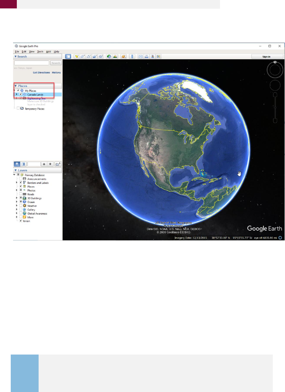
Drag the downloaded file into My Places in the menu on the left-side of the Google Earth screen.
This ensures that Canada Lands dataset will be available to you the next time you open Google
Earth. It will not need to be downloaded again. The next time you open Google Earth from your
desktop, the Canada Lands information will be available there.
Data is always current because you download a link to the data that gets automatically updated.
Canada Lands will be added to My Places in Google Earth and will remain active and up-to-date
until you delete the KMZ file.
TIP:
The KMZ file is designed to work best with Google Earth 4.2 or later versions,
but the format is also compatible with Google Maps, Google Maps for Mobile,
Microsoft Virtual Earth, and NASA's World Wind.

April 2022 | Version 4
13
CLSS Canada Lands In Google Earth
USING GOOGLE EARTH
How to Navigate
The navigation controls are in the upper right corner of the map and fade when you are not
using them.
To show navigation controls, move the mouse over the right corner of the map.
If you do not see the navigation controls, in the top menus, click View > Show
Navigation > Automatically.
Show or hide the compass: In the top menu, click View > Show Navigation.
• Use look (top of the controls) to look around from one vantage point.
• Click and drag the ring to rotate the views.
• Use move (center of the controls) to move down, up, right, or left.
• Use the zoom slider to zoom in or out (+ to zoom in, - to zoom out).

April 2022 | Version 4
14
CLSS Canada Lands In Google Earth
What you will see
In most cases, Canada Lands in KMZ format have four levels of detail:
1. A general point location of the Canada Land for viewing at large extents
2. Zooming in on the point will load the administrative boundaries
3. Zooming in further will transition the display to parcel level data
4. Clicking on the place marks at the centre of each parcel will display and link to further
cadastral information.

April 2022 | Version 4
15
CLSS Canada Lands In Google Earth
HOW TO SEARCH
Do not use this
Search tool as it
searches on
Google and not
within the Canada
Lands KMZ file.
Select
province
or
territory
Find
Canada
Land
name in
dropdown
list or type
name
here
To search:
1. Select the province or territory from the list of options.
2. Type the Canada Land name or select from the dropdown list, and then double-click on
the desired option from the list that appears.

April 2022 | Version 4
16
CLSS Canada Lands In Google Earth
Your result will look like this:
TIP:
Push the R button on the keyboard every time you zoom or move, to get
a bird’s eye view instead of a perspective or rotated view.

April 2022 | Version 4
17
CLSS Canada Lands In Google Earth
Hover your mouse over the lots to have the names appear (Parcel designators), and then click on the
name, which will show the CLSS information in a popout window.
Hover
mouse
over the
lots to
have the
names
appear

April 2022 | Version 4
18
CLSS Canada Lands In Google Earth
HOW TO READ YOUR RESULTS
Click on the link for
English to open the
Survey Plan Details
window where the
plan can be
downloaded.
Download Digital
Cadastral Data
(See page 20)
This links to Map
Browser, zooming
to the relevant
parcel.
In the Canada Lands KMZ Overlay, when zoomed in to the parcel level data, clicking on the
centre place mark will display:
• Description — Describes the type of parcel, such as LAND PARCEL, MINERAL CLAIM,
EASEMENT, etc.
• NRCan PIN — The unique identification number created by NRCan for each parcel.
• Parcel Designator — Name of the Land Parcel shown on legal survey documents, which
usually includes the lot number.
• Plan Number — Click on the link for English to open the Survey Plan Details window
where the plan can be downloaded.
• Administrative Area — The Canada Land administrative area, this parcel is associated
with (Reserve, National Park, etc.)
• Download Digital Cadastral Data link (See page 20).
• Interactive Map — A link to Map Browser, which once selected will zoom to the
relevant parcel after a few moments.

April 2022 | Version 4
19
CLSS Canada Lands In Google Earth
Clicking the English link takes you to the Survey Plan Search tool. See the Survey Plan Search
guide for more information.
To return, click the Back to Google Earth button.

April 2022 | Version 4
20
CLSS Canada Lands In Google Earth
SEARCH RESULTS TIPS
Trouble viewing land parcels
If you are having difficulty
viewing the land parcels,
turn off the Terrain Layer,
which makes Google Earth
3D and sometimes
interferes with the lines.
Accessing FTP links from Google Earth
The “Download Digital Cadastral Data” links in Canada Lands in Google Earth point to an FTP
site. Default security settings in Google Earth do not allow users to open these links directly
from the application.
To access the data, copy
the Download Digital
Cadastral Data links into a
web browser address bar
by right-clicking the link
and selecting Copy Link.

21
CLSS Canada Lands In Google Earth
April 2022 | Version 4
Settings in Google Earth can also be changed to allow the opening of FTP links. These changes
should only be made if you agree with the security impact to your computer. From the menus,
select Tools > Options and select the “General” tab. Next, check the options Display > “Show web
results in external browser” and Placemark balloons > “Allow access to local files and personal
data.”

April 2022 | Version 4
22
CLSS Canada Lands In Google Earth
SEARCH EXAMPLES
EXAMPLE 1: If you are looking for a certain lot, you can navigate to the lot if you know
where it is located. This allows you to find specific information about the lot, such as the Plan
Number.
This example uses
Kitselas Reserve No 1, but
there are other reserves
for Kitselas First Nation
(Chimdimash 2 and
Chimdimash 2A).
Select British Columbia,
and then begin typing
the name of the Reserve.
A list of options will be
provided. Select Kitselas
Reserve from the list,
and double click.
TIP:
Keep in mind that a First Nation might have multiple reserves.

April 2022 | Version 4
23
CLSS Canada Lands In Google Earth
The search produces this result:
Hover mouse over the lots to have the names appear, or zoom in closer to find the specific lot
you are looking for.

April 2022 | Version 4
24
CLSS Canada Lands In Google Earth
SEARCH EXAMPLES
EXAMPLE 2: If you are looking for lot 106 on Mistawasis Reserve No. 103 but you do not know
where it is located, you can expand the dropdown list of Mistawasis Reserve No. 103 and scroll
down to lot number 106 within the layer Land_Parcel__Parcelle_de_terre. Double-click to
zoom on the parcel and to open the information page for lot 106.
Select Saskatchewan, and
then begin typing the
name of the Reserve. A list
of options will be
provided. Select
Mistawasis IR 103 from the
list, and double click.

April 2022 | Version 4
25
CLSS Canada Lands In Google Earth
The search produces this result:

April 2022 | Version 4
26
CLSS Canada Lands In Google Earth
Then type the number of the lot you
are looking for. The parcels
corresponding to 106 will be displayed
successively. Double-click to zoom on
the parcel and to open the lot 106
information page.
TIP:
When you become comfortable with Canada Lands in Google Earth you can use the
many tools of Google Earth. For more information, select Help Resources under the
Help tab.

April 2022 | Version 4
27
CLSS Canada Lands In Google Earth
HELP
To access Google Earth online help, go to:
https://support.google.com/earth/?hl=#topic=7364880
NEED MORE HELP?
For terms and abbreviations please refer to the glossary.
For help with survey plans, please refer to the National Standards for the Survey of Canada Lands
and the Interdepartmental and Intergovernmental Agreements.
For any other information, contact your Surveyor General Branch Regional Office:
• Alberta Regional Office
• Atlantic Regional Office
• British Columbia Regional Office
• Manitoba Regional Office
• Northwest Territories Regional Office
• Nunavut Regional Office
• Ontario Regional Office
• Quebec Regional Office
• Saskatchewan Regional Office
• Yukon Regional Office

April 2022 | Version 4
28
CLSS Canada Lands In Google Earth
GLOSSARY
Administrative Area
The spatial extents of a jurisdiction created by combining all the associated parcels
together. These areas are generally Indian Reserves, Indian Lands, Settlement Lands,
National Parks, and Territorial Parks.
Administrative Plan
A plan created for administrative purposes and prepared under Section 31 of the
Canada Lands Surveys Act. They are used for defining boundaries or parcels and they
are approved by the Surveyor General before being recorded in the CLSR.
Air Space Parcel Survey
An air space parcel survey is a survey that describes a volume of space. Examples
include underground tunnels, bridges, and overhead walkways. Air space parcel
boundaries are independent of physical structures, and are defined by plane or
curved surfaces that have three-dimensional coordinates.
Allotment
The process by which an individual or a group receives lawful possession of reserve
land from the Band, the First Nation Council, or any other body entitled to assign land.
Artificial Boundary
An invisible boundary defined by a straight line, a circular curve of known radius,
or, in rare cases, a spiral curve. A rectangular parcel is usually formed by
artificial boundaries.
Boundary
Boundaries of parcels are ubiquitous. They exist in the field only and are created by
agreements between people. All peoples across all cultures mark the boundaries of
their parcels on the ground or in the air. These boundaries can serve economic, social
or security purposes. A boundary can be defined using artificial lines or natural
elements such rivers or ridge lines. On Canada Lands, only a Canada Lands Surveyor
can make the connection between the description of the land as presented on a
survey plan and the boundary itself in the field.
Boundary Surveys
Regulated expertise that incorporates technical, procedural and legal aspects related
to determining, describing and demarcating property and administrative
boundaries. Also referred to as Land Surveys, Cadastral Surveys, and Legal Surveys.
Cadastral dataset
Cadastral dataset, also known as digital cadastral data or survey fabric are
amalgamations of all the parcels and plan information. This amalgamation can
be used to support planning and management, but should not be used for
defining boundaries.
Cadastral Surveys
Regulated expertise that incorporates technical, procedural and legal aspects
related to determining, describing and demarcating property and administrative
boundaries. Also referred to as Boundary Surveys, Land Surveys, and Legal Surveys.
Canada Land
As defined in Section 24 of the Canada Lands Surveys Act, Canada Lands include the
Yukon, Northwest Territories and Nunavut; over 3100 Reserves; Canada's National
Parks; and Canada's offshore area.

29
April 2022 | Version 4
CLSS Canada Lands In Google Earth
Canada Lands in
Google Earth
Canada Lands in Google Earth is an overlay providing an integrated view of
boundaries and parcels in Google Earth.
Canada Lands Survey
Records (CLSR)
The Canada Lands Survey Records is a registry of legal survey documents and
contains survey plans, field notes, diaries, reports and other documents to
support property rights on Canada Lands.
Canada Lands Survey
The Canada Lands Survey System (CLSS) provides the framework and infrastructure
for defining, demarcating and describing boundaries of Canada Lands and of private
System (CLSS)
lands in the North.
Canada Lands Surveyor
Surveyors who hold a commission under Section 49 of the Canada Lands Surveyors
Act apply mathematics, property law and use of the latest measurement technology
(CLS)
to create parcels of land and establish property boundaries on Canada Lands.
The Canada Lands Survey System Map Browser is an interactive, map-based plan and
CLSS Map Browser
parcel search tool.
Community
Refers to rural and northern communities of the territories or in the provinces in
the Canada Lands Survey System.
A compiled plan is a plan of parcels or boundaries produced using survey field note
information of records in the CLSR, as well as incorporating that information shown
Compiled Plan
on plans registered in a provincial or territorial Land Titles office. Compiled plans are
a means to create parcels from a reliable survey fabric.
The objective of a condominium survey or condominium plan is to divide property
into parts to be owned individually (called “units”) and parts to be owned in common
Condominium Surveys
(called “common property” or “common elements”. For example, on a condominium
plan, a building can be defined by reference to floors, walls, and ceilings.
Control surveys provide horizontal and vertical positions of points or monuments to
Control Surveys
which other surveys are adjusted.
A system that is used to calculate, map or locate the position of objects, for example
Coordinates
geographic coordinates in degrees of latitude and longitude or Universal Transverse
Mercator (UTM) projected coordinates in metres.
Refers to Cree and Naskapi communities in northern Quebec in the Canada Lands
Cree-Naskapi
Survey System.
Digital cadastral data, also known as cadastral dataset or survey fabric are
amalgamations of all the parcels and plan information. This amalgamation can
Digital cadastral data
be used to support planning and management, but should not be used for
defining boundaries.
A non-exclusive, limited right affecting real property allowing one party to cross or
Easement
use another party’s land for specific purposes.

April 2022 | Version 4
30
CLSS Canada Lands In Google Earth
Explanatory Plan
An Explanatory Plan is a plan prepared from information found on plans and field
notes recorded in the Canada Lands Survey Records (CLSR), and is not based upon any
new field survey. An Explanatory Plan is used to define the boundaries of short-term
or non-exclusive interests such as short-term leases, utility easements, access roads
or right-of-ways, and First Nation surrender or designation votes.
Field Book
Surveyors use field books to record data and make notes while they are in the field.
Some of this field book information is shown on the survey plan and/or field notes
submitted to the Surveyor General.
Field Notes
Field notes are the synthesis of the data collected in the field during the execution
of the survey. Field notes of survey prepared by a surveyor and submitted to the
Surveyor General are filed in the CLSR in accordance with Section 18 of the
Canada Lands Surveys Act. Field notes can be included in a survey plan or not.
First Nation
In the Canada Lands Survey System, First Nations may refer to a band or a community
that is associated with one or more Indian reserves.
Indian Reserve
Tract of land set aside under the Indian Act or treaty agreements for the exclusive use
of a First Nation. A reserve can be held in common between different First Nations.
Indigenous Services
Canada (ISC)
ISC works and supports Indigenous peoples in assuming control of the delivery
of services at the pace and in the ways they choose, including access and
maintenance to land tenure systems such as the Indian Land Registry System (ILRS)
and the First Nations Land Registry System (FNLRS) to record property interests in
First Nations lands.
Internal Boundary
Internal boundaries mark the limits of the parcels inside a jurisdictional area, for
examples the internal boundaries of a First Nation reserve.
Jurisdictional
Boundary
With regard to land, a jurisdictional boundary is a boundary between two domains
that have separate jurisdictions over land administration. For surveys of Canada
Lands, jurisdictional boundaries include the boundaries of Indian Reserves, National
Parks, and Settlement Lands in the territories. The boundary of a road vested in a
province through an Indian Reserve or National Park is a jurisdictional boundary.
Keyword
Allows searching with keywords in the Canada Lands Survey System. The keyword
search only applies to documents title and description.
Land Description
A description of the extent and location of a parcel defined using survey plans or
any other documents.
Land Registry
A land registry is a set of records that anyone can search to find out what ownership,
leases, permits and other interests may apply to a parcel of land.
Land Surveys
Regulated expertise that incorporates technical, procedural and legal aspects
related to determining, describing and demarcating property and administrative
boundaries. Also referred to as Boundary Surveys, Cadastral Surveys, and
Legal Surveys.

April 2022 | Version 4
31
CLSS Canada Lands In Google Earth
Legal Surveys
Regulated expertise that incorporates technical, procedural and legal aspects
related to determining, describing and demarcating property and administrative
boundaries. Also refer to as Boundary Surveys, Land Surveys, and Cadastral Surveys.
Lot
Normally one of a series of parcels comprising a subdivision of a townsite used
to define the extent of land ownership or other exclusive use of land.
Mapping Product
Maps and plans other than survey plans can be registered in the Canada Lands Survey
System. Such mapping products do not create boundaries.
Mineral Claim Surveys
Surveys whose purpose is to define boundaries of subsurface interest for lease
purposes in the Yukon, Northwest Territories and Nunavut.
Municipal Boundary
In the Canada Lands Survey System, refers to official extent of the community
boundary as defined by territorial legislation.
National Park
In the Canada Lands Survey System, refers to Canada's National Parks included in
Canada Lands definition.
Natural Boundary
A boundary defined by a natural feature, such as a water boundary, a watershed line,
or a ridge line.
Not Applicable
The Not applicable filter can be used to search for items such as : Cancelled plans,
Compiled plans – Where field notes only, Diaries, Sketches, NTS Map sheets, Display
posters, Some Legal descriptions, Reports (non-survey), Mapping products, etc.
Official Plan
A plan confirmed by the Surveyor General under Section 29 of the Canada
Lands Surveys Act. Boundaries defined by the monuments shown on the Official
Plan become the true boundary lines. This type of plan is generally used for
jurisdictional boundaries.
Oil and Gas Wells
and Facilities
Limited right areas representing the spatial extent of an oil and gas well site
or facilities.
Oil and Gas
Right of way
See Right-of-Way.
Parcel
An area of land, usually surveyed, regardless of dimensions, that is capable of
being used to define the extent of land ownership or other exclusive use of land.
It includes, but is not limited to, lots, blocks, subdivisions, roads, highways,
rights-of ways, condominium units, air space parcels, etc. A parcel has defined
limits, known as boundaries.
Parcel Designator
The name of the Land Parcel shown on legal survey documents, which usually
includes the lot number.

April 2022 | Version 4
32
CLSS Canada Lands In Google Earth
Parcel Identification
Number (PIN)
Unique numbers (usually 7 to 9 digits) automatically generated by the survey system
and the land registry system for a parcel based on the land description. Different PIN
numbers can be assigned to a parcel, for example a Natural Resources Canada PIN in
the Canada Lands Survey System and a Indigenous Services Canada PIN in the Indian
Land Registry System. The parcels may also have been assigned an existing PIN, the
same number in both systems.
Plan
See Survey Plan.
Plan and Field Notes
Survey plan and field notes combined under one plan.
Plan Number
Number given to the plan in the Canada Lands Survey System. This number can be a
Canada Lands Survey Records plan (for example 106523 CLSR) or a Regional Survey
plan (for example 5233 RSQ in the province of Quebec).
Project Number
Project number issued by the Surveyor General Branch is made of the year, the
operating area and a sequential number (for example, 201912052, opened in
Saskatchewan in 2019).
Protected Area
Protected lands as a result of the public interest or common good. In the Canada
Lands Survey System, these areas can include habitat, wilderness areas and other
special management areas.
Quad
A division of land used in the territories and defined by the National Topographic
System (NTS) Quads sheets, which divide areas in a systematic pattern and allows
parcels to be given a unique Parcel Identifier in the Canada Lands Survey System.
Reference and
Index Document
Reference and Index Documents are used for documents that are not survey
documents. For the most part, they will be documents prepared for a client or for
internal office use, which could have the purpose of assisting with planning or
depicting various situational information. For example, index maps could be used by
office staff to track instruments and land transfers on a reserve. Mapping prepared
for requests and projects would also fall into this category as these items would be
recorded in the CLSR at that time.
Registration Plan
A Registration Plan is a type of administrative plan. The registration plan is no longer a
product used since 2015. It is a graphical description of the boundaries prepared from
information contained in existing documents, field notes of survey, controlled aerial
photographs or maps and from information found in land transaction documents.
Related Plan
Allows searching with a plan number to find all the plans or documents associated
with it.
Report
See Survey Report.
Right-of-Way
A parcel, corridor, or other physical tract of land used for the passage of people,
vehicles, or materials such as oil and gas, electricity, telecommunications, or water.
Road and Railroad
Allows searching for surveys whose purpose is to create roads or railroads in the
Canada Lands Survey System.

April 2022 | Version 4
33
CLSS Canada Lands In Google Earth
Settlement
Land Claim
Allows searching in the Canada Lands Survey System for survey documents related to
lands transferred to aboriginal groups in accordance with the provisions of land claim
settlement legislation as well as lands created under Comprehensive Land Claims
Process that do not or will not have Indian Reserve status under the Indian Act.
Site Plan
Plan showing the property “as it is built” or “as-built” at a particular point in time.
Subdivision
Action of dividing a piece of land into two or more parcels or lots. Within the Canada
Lands Survey System, subdivisions are used in the Yukon to identify parcels of land.
Survey Fabric
Survey fabric, also known as cadastral fabric, cadastral datasets or digital cadastral
data are amalgamations of all the parcels and plan information. This amalgamation
can be used to support planning and management, but should not be used for
defining boundaries.
Survey Plan
A plan that defines boundaries and parcels of land. A survey plan is used to describe
one or more parcels. There are different types of Canada Lands survey plans:
administrative plans, compiled plans, explanatory plans, official plans and
registration plans.
Survey Plan Search
The Survey Plan Search is a text-based search tool for all current and historical
records in the Canada Lands Survey System.
Survey Project Search
The Survey Project Search is a text-based search tool for in-progress survey projects
in the Canada Lands Survey System.
Survey Records
In the Canada Lands Survey System, survey records are the legal survey documents
(plans, field notes, reports, etc.).
Survey Report
In the Canada Lands Survey System, a survey report is used when more information
or documentation is required than that shown on the submitted plans and/or
field notes.
Survey Sketch
Drawing or plan which purpose is to present a sketch of an area. Some sketches are
recorded in the CLSS but are not approved or confirmed by the Surveyor General.
Surveyor
The surveyor makes the connection between the description of the land as presented
on paper or in the digital world and the reality in the field.
Surveyor General
Branch (SGB)
The Surveyor General Branch includes the Surveyor General and his employees. The
Surveyor General has the legal responsibility, subject to the direction of the Minister of
Natural Resources, to manage all surveys on Canada Lands and to maintain all the
original plans, journals, field notes and other documents connected with those surveys.

April 2022 | Version 4
34
CLSS Canada Lands In Google Earth
Surveyor General
Branch Regional Office
The regional structure of SGB allows to be responsive to the needs of people working
with the Canada Lands Survey System. To contact your Surveyor General Branch
Regional Office :
• Alberta Regional Office
• Atlantic Regional Office
• British Columbia Regional Office
• Manitoba Regional Office
• Northwest Territories Regional Office
• Nunavut Regional Office
• Ontario Regional Office
• Quebec Regional Office
• Saskatchewan Regional Office
• Yukon Regional Office
Surveys In Progress
Survey work currently underway.
Township
A land division system used in Canada that divides up the lands into sections of one
square mile on township plans. The Canada Lands Survey System allows searching for
township information throughout the prairie provinces.
Water Boundary
A boundary of an upland parcel bounded by a body of water. It can be the water’s
edge, the vegetation edge, the mean high water mark (MHWM), the ordinary high
water mark (OHWM), the mean low water mark (MLWM), or ad medium filum (amf).
Zoning and Land Use
Allows searching for surveys whose purpose is to create zoning and land use in the
Canada Lands Survey System.
