

Contents
Summary 2
Introduction 3
Vessel tracking analysis 4
Unidentified vessels and vessels without authorization by SPRFMO 6
AIS misuse and irregularities 6
Support vessels: Transshipment and bunkering 8
Encounters and loitering events 8
Port State analysis 11
Dark fleet 11
VIIRS image analysis 11
Historic links to IUU fishing reports 14
Conclusions 15
Annex 1 - Caveats & disclaimer 16
1

Summary
Global Fishing Watch in support of coastal States in Latin America seeks to improve transparency
for the squid fleet operating in the Southeast Pacific by generating a series of periodic reports on
the fleet’s activity in 2021. The reports review the spatial and temporal distribution of the fleet, along
with fishing effort, encounters, loitering events and port visits. The analysis also aims to identify
possible dark vessels—vessels that do not publicly broadcast their location or appear in public
monitoring systems.
The following are key highlights from October 1-31, 2021:
● The squid fleet operated on the high seas, averaging a distance of 150 nautical miles off of
Peru’s exclusive economic zone.
● All vessels identified on AIS that were found operating inside the Convention Area were
matched to the South Pacific Regional Fisheries Organisation's (SPRFMO) register of
authorized vessels.
● Three squid vessels were using multiple Maritime Mobile Service Identity numbers while
transiting and fishing in the Southeast Pacific Ocean.
● The analysis of fishing activity revealed no fishing activity within the banned area designated
under China’s voluntary fishing moratorium (see area workspace here).
Number of vessels active in the area
● 374 unique MMSI
● 20 fish carriers
● 4 bunker vessels (tankers)
Main area of vessel activity
High seas adjacent to Peru
Total number of fishing days
8,697
Carrier vessel encounter events
350
Carrier vessel loitering events
471
Port visits
9
Average distance from Peru’s EEZ
150 nautical miles
2

Situation Report: Southeast Pacific Distant
Water Squid Fleet, October 2021
Introduction
The jumbo flying squid (Dosidicus gigas) is the most abundant cephalopod species in the
Southeastern Pacific Ocean and one of the most important cephalopod fisheries in the world
(Ibáñez et al., 2015). The range of this species extends from southern Chile to the North American
coast (FishSource), falling within the remit of the South Pacific Regional Fisheries Management
Organisation (SPRFMO), where it is the second largest fishery of this intergovernmental
management body. This species is of clear socio-economic importance, both commercially on the
high seas within the SPRFMO area and within the exclusive economic zones (EEZ) of Chile and
Peru, as well as for small-scale fishers—in particular, Peru, where the squid fishery constitutes the
largest artisanal fishery.
Using our public data and machine learning, Global Fishing Watch is investigating the activity of the
squid fleet for October 1-31, 2021. Our analysis draws on a combination of sources of information:
1. Automatic identification system (AIS):
AIS transmits a ship’s position so that other ship operators are aware of its position. The
International Maritime Organization (IMO) and other management bodies require large ships,
including many commercial fishing vessels, to broadcast their position with AIS in order to
avoid collisions.
2. Visible infrared imaging radiometer suite (VIIRS):
The Suomi National Polar-orbiting Partnership (NPP) satellite has a sensor with a spatial
resolution of approximately 0.74 square kilometers, capable of detecting low light signals
from the Earth. Called VIIRS, it is able to detect fishing vessels that use bright lights to attract
target species to the surface such as the squid fishery in the eastern equatorial Pacific.
3. SPRFMO registry
According to the CMM 05, Record of Vessels, the SPRFMO Commission established a
register of fishing vessels which are authorized to fish in the SPRFMO Convention Area.
The analysis focuses on the area of interest (AOI) described below (Figure 1) during October 1-31,
2021. This area was selected based on historic activity of the squid fleet in the region, in particular
along Peru and Ecuador’s (Galápagos) EEZ and an area on the equator about 1,500 nautical miles
west of the Ecuadorian Galápagos’ EEZ.
3

Figure 1: Area of Interest within the Southeast Pacific Ocean
© 2021 Global Fishing Watch
Vessel tracking analysis
Using AIS data and the Global Fishing Watch fishing effort algorithm for night time squid fishing
1
a
total of 374 unique Maritime Mobile Service Identification (MMSI) numbers completed an estimated
8,697 total days of fishing
2
over October (Figure 2). The status of the top 10 vessels detected in the
AOI is summarized in Table 1. The number of AIS messages received per vessel operating inside the
AOI in October varied significantly, ranging between 6-29,556 transmissions received.
2
This study considered a “fishing day” as any 24-hour period where the Global Fishing Watch algorithm detected at
least one hour of movements that were consistent with night time squid jigging.
1
Global Fishing Watch has developed algorithms to automatically detect different types of fishing activity from vessel
tracking data. Kroodsma, D. et al, 2018. Tracking the global footprint of fisheries. Science, 359 (6378), pp.904-908.
4

Table 1: 10 Most Active Squid Fishing Vessels Operating in the Southeast Pacific, October 2021
Note: Click to see the full list of vessels
3
Vessel name
IMO
Fishing days
4
AIS positions
Flag state
FU YUAN YU 7669
9900069
6
29556
China
HONGPU31
9907043
28
26769
China
LU RONG YUAN YU 277
8786569
NA
26460
China
LURONGYUANYU539
9831646
5
26456
China
LURONGYUANYU538
9831634
6
26047
China
HUA YING 208
9840611
31
26019
China
NINGTAI28
9870135
31
25920
China
JIADE56
9912189
29
25877
China
LURONGYUANYU582
9871983
29
25692
China
SHUNZHOU817
8776538
31
25122
China
© 2021 Global Fishing Watch
Figure 2: AIS-Detected Squid Vessel Activity, October 2021
© 2021 Global Fishing Watch
4
This study considered a “fishing day” as any 24 hour period where the Global Fishing Watch algorithm detected at least
one hour of movements that were consistent with night time squid jigging.
3
Full list of fishing vessels.
5

Red points in the figure above represent the last detected position of each fishing vessel. The blue
lines represent the track of the vessels from October 2021. Figure 2 shows the AIS tracking data of
squid vessels mostly situated at an average distance of 150 nautical miles off of Peru.
Figure 3: AIS-Detected Squid Fishing Effort, October 2021
© 2021 Global Fishing Watch
Unidentified vessels and vessels unmatched to a SPRFMO authorization
AIS did not identify a single active vessel inside the SPRFMO Convention Area that could not be
matched with an authorization to fish.
AIS misuse and irregularities
Table 2 shows three squid vessels that demonstrate AIS irregularities by broadcasting with multiple
MMSI Identity numbers while transiting and fishing in the Southeast Pacific Ocean. Whether the
discrepancies in MMSI numbers reflect different broadcasting devices, or are due to satellite signal
detection error or human error at the point of handling the AIS device, is unknown. The true reason
behind vessels operating with multiple AIS devices with different MMSI and identity information is
6

unclear; however, this highlights a real challenge in the monitoring, control, and surveillance of these
vessels from remotely observed data.
Table 2: Vessels Associated with AIS Misuse and Irregularities
Vessel name
MMSI
Callsign
IMO
Flag state
AIS positions
HAN YI 78
412402273
BZ4VB
8776239
China
665
412420273
China
2,128
LURONGYUANYU701
412336833
BZYM2
9870783
China
16,750
412990998
China
56
SHUNZE805
412420535
BZ4VO
8779994
China
241
412549176
China
666
© 2021 Global Fishing Watch
Figure 4: Vessel Using Two MMSI Numbers
© 2021 Global Fishing Watch
7

Support vessels: Transshipment and bunkering
Based on AIS data, 24 support vessels—20 fish carriers and 4 bunker vessels—were operating within
the AOI during October, 2021.
Table 3: 10 Most Active Support Vessels Operating in the Southeast Pacific Ocean
Note: Click to see the full list of vessels.
MMSI
Vessel name
Flag state
Type
356470000
ANGEL101
Panama
Tanker
356802000
ANGEL106
Panama
Fish carrier
351383000
CHENGHANG
Panama
Fish carrier
412440781
FU YUAN YU YUN 992
China
Fish carrier
412440687
FUYUANYUYUN995
China
Fish carrier
374610000
HAI FENG 678
Panama
Fish carrier
356514000
HAIFENG618
Panama
Fish carrier
373039000
HAIFENG688
Panama
Fish carrier
374198000
HAIFENG718
Panama
Fish carrier
371596000
HAIGONGYOU303
Panama
Tanker
© 2021 Global Fishing Watch
Encounters and loitering events
Encounters and loitering events by support vessels occurred in areas where the fishing vessels were
concentrated in October. Figure 6 shows the distribution of encounters and Figure 7 the distribution
of loitering events by support vessels. Each point represents a possible transshipment and loitering
event. See also Global Fishing Watch Map - carrier vessel encounter analysis workspace.
Twenty-four non-fishing vessels had a total of 350 encounters and 471 loitering events (Table 4) in
the Southeast Pacific Ocean during October 2021. Non-fishing vessels were flagged to China,
Liberia and Panama, which accounted for 8.2 percent, 14.9 percent and 76.9 percent of encounters,
respectively and 13.8 percent, 20.2 percent and 66 percent of loitering events, respectively.
Table 4: Summary of Encounters and Loitering Events by Flag State
Flag state
Vessel class
Number of vessels
Total encounter events
Total loitering events
Panama
Fish carrier
13
204
250
China
Fish carrier
6
29
65
Panama
Tanker
3
65
61
Liberia
Fish carrier
1
35
47
Liberia
Tanker
1
17
48
Total
All
24
350
471
© 2021 Global Fishing Watch
8
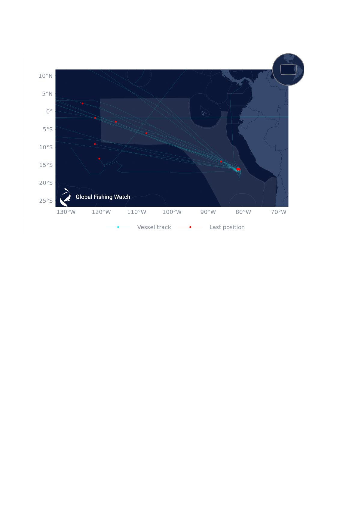
Figure 5: Last Detected Position of Support Vessels
Note: Red points represent the last detected position of each fish carrier and tanker. The blue lines represent their tracks
during October 2021.
© 2021 Global Fishing Watch
9

Figure 6: Distribution of Encounters by Support Vessels With Squid Vessels
© 2021 Global Fishing Watch
Figure 7: Distribution of Loitering Events by Support Vessels
© 2021 Global Fishing Watch
10

Port visits
A total of nine port visits by carriers and tankers were identified using AIS between October 1-31,
2021. Support vessels visited ports in three countries: China, Peru, and the Republic of Korea (Table
5).
Table 5: Summary of Port visits by Fishing Vessels and Non-Fishing Vessels
Port
Flag State
Number of port visits
Callao
Peru
5
Busan
Republic of Korea
3
Zhoushan
China
1
© 2021 Global Fishing Watch
Dark Fleet
VIIRS image analysis
The Suomi National Polar-orbiting Partnership satellite has a sensor with a spatial resolution of
approximately 0.74 square kilometers, capable of detecting low light signals from the Earth.
Commonly referred to as VIIRS, this satellite cano detect fishing vessels that use bright lights to
attract target species to the surface such as the squid fishery in the eastern equatorial Pacific.
The analysis of AIS data shows no distant water vessels operating within any of the coastal States’
waters inside the AOI during October 2021. VIIRS vessel detections were used to identify potential
nighttime fishing incursions into the EEZs by large industrial squid vessels to supplement the AIS
analysis. No suspicious VIIRS detections were identified during October inside any coastal States’
EEZs.
According to the VIIRS daily detections from October 2021(Figures 8 and 9) the squid fleet was
concentrated on the high seas off Peru’s EEZ; the same pattern was detected with AIS data (Figure
2).
11

Figure 8: Daily VIIRS Detections, October 2021
Note:
Area A represents the high seas adjacent to Galápagos; Area B represents the Equatorial Pacific high seas; Area C
represents the high seas adjacent to Peru.
© 2021 Global Fishing Watch
Figure 9 shows the number of VIIRS detections as a bar graph for three areas of the study’s AOI.
The bars are split by whether or not detections were matched directly to AIS. The line graph overlaid
represents the daily count of squid vessels transmitting on AIS. If the bars were greater than the line
chart, it would indicate the existence of a “dark fleet’—vessels that are not transmitting AIS data.
During the month of October, the bars were consistently less than the daily AIS count of squid
vessels across these three regions, suggesting a high proportion of the fleet is using AIS.
The increase of daily VIIRS detections inside the high seas area adjacent to Peru’s EEZ mainly
corresponded to the squid fleet’s movement toward Peru's EEZ, as previously described with VIIRS
and AIS information.
12

Figure 9: Daily Count of VIIRS Detections and AIS
Note: HS refers to high seas
© 2021 Global Fishing Watch
13

Historic links to IUU fishing reports
Five squid fishing vessels identified as active in the AOI during October 2021 had prior records that
were associated with illegal, unreported and unregulated (IUU) fishing events. These vessels are
described in Table 6.
Figure 10: AIS Tracks of Vessels with Historical Links to IUU Fishing Reports
© 2021 Global Fishing Watch
Table 6: SPRFMO-Authorized Vessels with Historical Links to IUU Fishing
Vessel Name
MMSI
IMO
Flag
state
Type of
fishery
SPRFMO List
2020
Date
Media
report
AIS positions
October
2021
NING TAI 717
(ex RUN DA 608)
412549269
8778770
China
Squid
Authorised
1/10/2018
Peru
2,784
JING YUAN 626
412331089
9784568
China
Squid
Authorized
2/21/2018
Argentina
8,101
HUA XIANG 801
412421062
9822695
China
Squid
Authorized
3/19/2020
Argentina
806
LU RONG YUAN YU
688
412331078
8775883
China
Squid
Authorized
5/01/2020
Argentina
400
LU RONG YUAN YU
668
412549383
8775871
China
Squid
Authorised
4/28/2020
Argentina
19,060
© 2021 Global Fishing Watch
14

Conclusions
The analysis identified five vessels with previous IUU-related historic events. Furthermore, three
vessels were identified to be using two MMSI numbers between October 1-31, 2021. These findings
can help alert port States to conduct appropriate inspections.
AIS data can increase the transparency of the squid fishery in the Southeast Pacific Ocean and can
be used by flag and coastal States to support monitoring, control, and surveillance. It is
recommended that States cross-check AIS data with reported information from fishing and carrier
vessels to help ensure vessels are correctly authorized and reporting catch in line with SPRFMO’s
conservation and management measures.
15

Annex 1 - Caveats & Disclaimer
Published in October 2021 by Global Fishing Watch. Any reproduction in full or part of this
publication must be in accordance with the rules below, and mention the title and credit the
above-mentioned publisher as the copyright owner.
Reproduction of this publication for resale or other commercial purposes is prohibited without prior
written permission. Reproduction of the photos for any purpose is subject to Global Fishing Watch’s
prior written permission.
The designations employed in this publication and the presentation of material therein do not imply
the expression of any opinion whatsoever on the part of Global Fishing Watch concerning the legal
status of any country, area, or territory or of its authorities.
AIS provides the only open source monitoring tool for high seas fishing. AIS relies on voluntary
transmission and is restricted to the vessels which have AIS devices installed and operating, making
the data records incomplete. An additional source of uncertainty in AIS-based data relates to poor
satellite reception, in areas with high vessel traffic, such as the South China Sea and English
Channel. That said, the reception is generally good in the focal area of this report, however, the
boats operating within the squid fishery often use Class B AIS transponders that broadcast at a
lower rate when the vessels move slower than two knots. The majority of squid vessels fish by
drifting with the currents
5
at a speed less than two knots, therefore the AIS messages received by
these vessels and estimates surrounding their AIS-based fishing effort will be conservative.
Nevertheless, in the absence of any other information, these data can be used to characterize the
spatial extent and relative activity of the squid fleet in the area. This report was completed by
manual review of AIS data and may differ to the information displayed in our automated public map
or carrier vessel portal.
“Encounters” are identified when AIS data indicates that two vessels may have conducted a
transshipment, based on the movements of the two vessels. Global Fishing Watch identifies
encounters from AIS data as locations where two vessels, a carrier and fishing vessel, were within
500 meters for at least two hours and traveling at a median speed less than 2 knots, while at least
10 kilometers from a coastal anchorage.
“Loitering Events” occur when a single vessel exhibits behavior indicative of a potential encounter
event. Loitering is estimated using AIS data, including vessel speed, duration in a given location, and
distance from shore. Loitering occurs when a carrier vessel travels at average speed of < 2 knots,
while at least an average of 20 nautical miles from shore. It is possible that loitering events do not
indicate a potential transshipment, but another event in which a vessel may remain fairly steady,
including maintenance or waiting outside of port for permission to dock.
5
Taconet, M., Kroodsma, D., & Fernandes, J.A. 2019. Global Atlas of AIS-based fishing activity - Challenges and
opportunities. Rome, FAO. page 352. http://www.fao.org/3/ca7012en/CA7012EN.pdf.
16

17
